Darby Bushes

Wood, Forest in Huntingdonshire Huntingdonshire

England

Darby Bushes

Woodland north of Conington
Woodland north of Conington Credit: Jonathan Thacker

Darby Bushes is a small woodland area located in Huntingdonshire, a historic county in the east of England. Nestled within the beautiful countryside, this forested region offers a tranquil escape from the hustle and bustle of urban life.

Covering an area of approximately 50 acres, Darby Bushes is characterized by its dense growth of trees, predominantly consisting of oak, birch, and beech. The woodland floor is adorned with a rich carpet of wildflowers, creating a picturesque and vibrant landscape during the spring and summer months.

The forest is intersected by several winding footpaths, providing visitors with the opportunity to explore its natural wonders. As you wander through the woods, you may encounter a variety of wildlife, including squirrels, rabbits, and various species of birds. The peaceful atmosphere and abundance of flora and fauna make Darby Bushes an ideal spot for nature lovers and birdwatchers.

In addition to its natural beauty, Darby Bushes also holds historical significance. The forest has been a part of the local landscape for centuries and is steeped in folklore and legends. The area was once used for hunting by the nobility, and remnants of old hunting lodges can still be found scattered throughout the woods.

Today, Darby Bushes is a popular destination for outdoor enthusiasts, offering opportunities for walking, hiking, and picnicking. Whether you are seeking a quiet retreat or an adventure in nature, Darby Bushes provides a serene and enchanting environment for all to enjoy.

If you have any feedback on the listing, please let us know in the comments section below.

Darby Bushes Images

Images are sourced within 2km of 52.476677/-0.26643289 or Grid Reference TL1787. Thanks to Geograph Open Source API. All images are credited.

Woodland north of Conington
Former taxiway, RAF Glatton RAF Glatton opened as a USAF base in 1943. It closed in 1948 <span class="nowrap"><a title="https://en.wikipedia.org/wiki/RAF_Glatton" rel="nofollow ugc noopener" href="https://en.wikipedia.org/wiki/RAF_Glatton">Link</a><img style="margin-left:2px;" alt="External link" title="External link - shift click to open in new window" src="https://s1.geograph.org.uk/img/external.png" width="10" height="10"/></span>
Despite its short life it has had a major impact on the surroundings of Conington with many roads clearly having originally been part of the base. Concrete beneath the tarmac is the giveaway.
Former taxiway, RAF Glatton
RAF Glatton opened as a USAF base in 1943. It closed in 1948 LinkExternal link Despite its short life it has had a major impact on the surroundings of Conington with many roads clearly having originally been part of the base. Concrete beneath the tarmac is the giveaway.
Church Street, Holme
Tree lined track off Glatton Lane Not a public right of way.
Tree lined track off Glatton Lane
Not a public right of way.
Old roadway at Conington
Horses and sheep, Conington
Track towards Moor Close Spinney, Conington
Track and Moor Close Spinney, Conington
Cut through a wheat field, Conington
Stubble field at Conington Looking towards Home Farm.
Stubble field at Conington
Looking towards Home Farm.
Stubble field at Holme The buildings of Peterborough Business Airport in the distance.
Stubble field at Holme
The buildings of Peterborough Business Airport in the distance.
Holme Church of England Primary School
St Giles' church, Holme Designed in 1862 by Edward Browning <span class="nowrap"><a title="https://en.wikipedia.org/wiki/Edward_Browning" rel="nofollow ugc noopener" href="https://en.wikipedia.org/wiki/Edward_Browning">Link</a><img style="margin-left:2px;" alt="External link" title="External link - shift click to open in new window" src="https://s1.geograph.org.uk/img/external.png" width="10" height="10"/></span> partly using old materials <span class="nowrap"><a title="https://historicengland.org.uk/listing/the-list/list-entry/1215533?section=official-list-entry" rel="nofollow ugc noopener" href="https://historicengland.org.uk/listing/the-list/list-entry/1215533?section=official-list-entry">Link</a><img style="margin-left:2px;" alt="External link" title="External link - shift click to open in new window" src="https://s1.geograph.org.uk/img/external.png" width="10" height="10"/></span>
St Giles' church, Holme
Designed in 1862 by Edward Browning LinkExternal link partly using old materials LinkExternal link
Roadside trees, Glatton Lane
A1(M) southbound, south of Stilton The A1 is the longest numbered road in the UK at 410 miles long. It connects London with Edinburgh, via the east of England. 
For much of its path it follows the Great North Road the old coaching route between London and Edinburgh. Several sections of the route are classified as motorway A1(M). The modern A1 bypasses the towns the Great North Road passed through and is dual carriageway for most of its route through England.
A1(M) southbound, south of Stilton
The A1 is the longest numbered road in the UK at 410 miles long. It connects London with Edinburgh, via the east of England. For much of its path it follows the Great North Road the old coaching route between London and Edinburgh. Several sections of the route are classified as motorway A1(M). The modern A1 bypasses the towns the Great North Road passed through and is dual carriageway for most of its route through England.
Peterborough Business Airport
Glatton Ways Bridge, A1(M) The A1 is the longest numbered road in the UK at 410 miles long. It connects London with Edinburgh, via the east of England. 
For much of its path it follows the Great North Road the old coaching route between London and Edinburgh. Several sections of the route are classified as motorway A1(M). The modern A1 bypasses the towns the Great North Road passed through and is dual carriageway for most of its route through England.
Glatton Ways Bridge, A1(M)
The A1 is the longest numbered road in the UK at 410 miles long. It connects London with Edinburgh, via the east of England. For much of its path it follows the Great North Road the old coaching route between London and Edinburgh. Several sections of the route are classified as motorway A1(M). The modern A1 bypasses the towns the Great North Road passed through and is dual carriageway for most of its route through England.
A1(M), northbound The A1 is the longest numbered road in the UK at 410 miles long. It connects London with Edinburgh, via the east of England. 
For much of its path it follows the Great North Road the old coaching route between London and Edinburgh. Several sections of the route are classified as motorway A1(M). The modern A1 bypasses the towns the Great North Road passed through and is dual carriageway for most of its route through England.
A1(M), northbound
The A1 is the longest numbered road in the UK at 410 miles long. It connects London with Edinburgh, via the east of England. For much of its path it follows the Great North Road the old coaching route between London and Edinburgh. Several sections of the route are classified as motorway A1(M). The modern A1 bypasses the towns the Great North Road passed through and is dual carriageway for most of its route through England.
Show me another place!

Darby Bushes is located at Grid Ref: TL1787 (Lat: 52.476677, Lng: -0.26643289)

Administrative County: Cambridgeshire

District: Huntingdonshire

Police Authority: Cambridgeshire

What 3 Words

///equivocal.confident.fluffed. Near Stilton, Cambridgeshire

Related Wikis

Holme, Cambridgeshire

Holme is a village and civil parish in Cambridgeshire, England. Holme lies approximately 7 miles (11 km) south of Peterborough, near Conington and Yaxley...

Peterborough Business Airport

Peterborough Business Airport (ICAO: EGSF) is a privately owned airfield in the English county of Cambridgeshire near the villages of Holme and Conington...
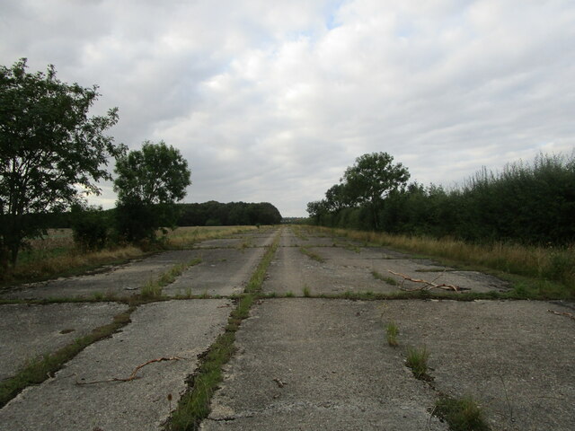
RAF Glatton

Royal Air Force Glatton or more simply RAF Glatton is a former Royal Air Force station located 10 miles (16 km) north of Huntingdon, Cambridgeshire, England...

Battle of the Holme

The Battle of the Holme took place in East Anglia on 13 December 902 where the Anglo-Saxon men of Wessex and Kent fought against the Danelaw and East Anglian...
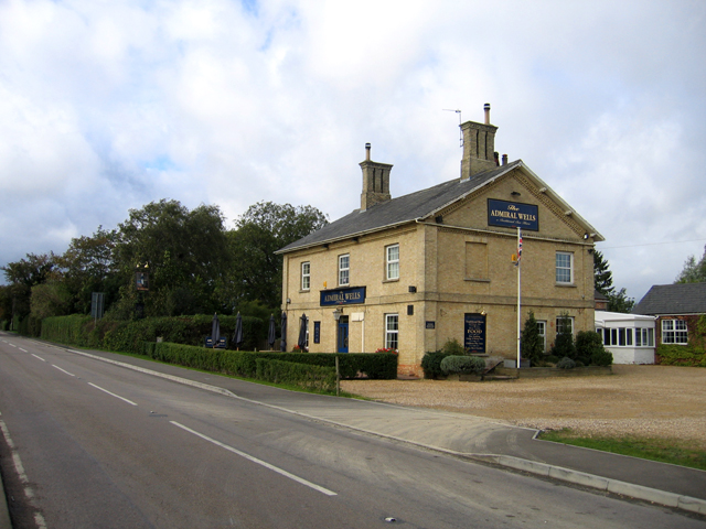
Admiral Wells

The Admiral Wells is a public house in Holme, Huntingdonshire, now in Cambridgeshire. Nearby Holme Fen is 2.75 metres (9.0 feet) below sea level, and the...

Holme railway station (Cambridgeshire)

Holme railway station is a former station in Holme, Cambridgeshire. == History == The first section of the Great Northern Railway (GNR) - that from Louth...

All Saints Church, Conington

All Saints Church is a redundant Anglican church in the village of Conington in the Huntingdonshire district of Cambridgeshire, England. It is recorded...

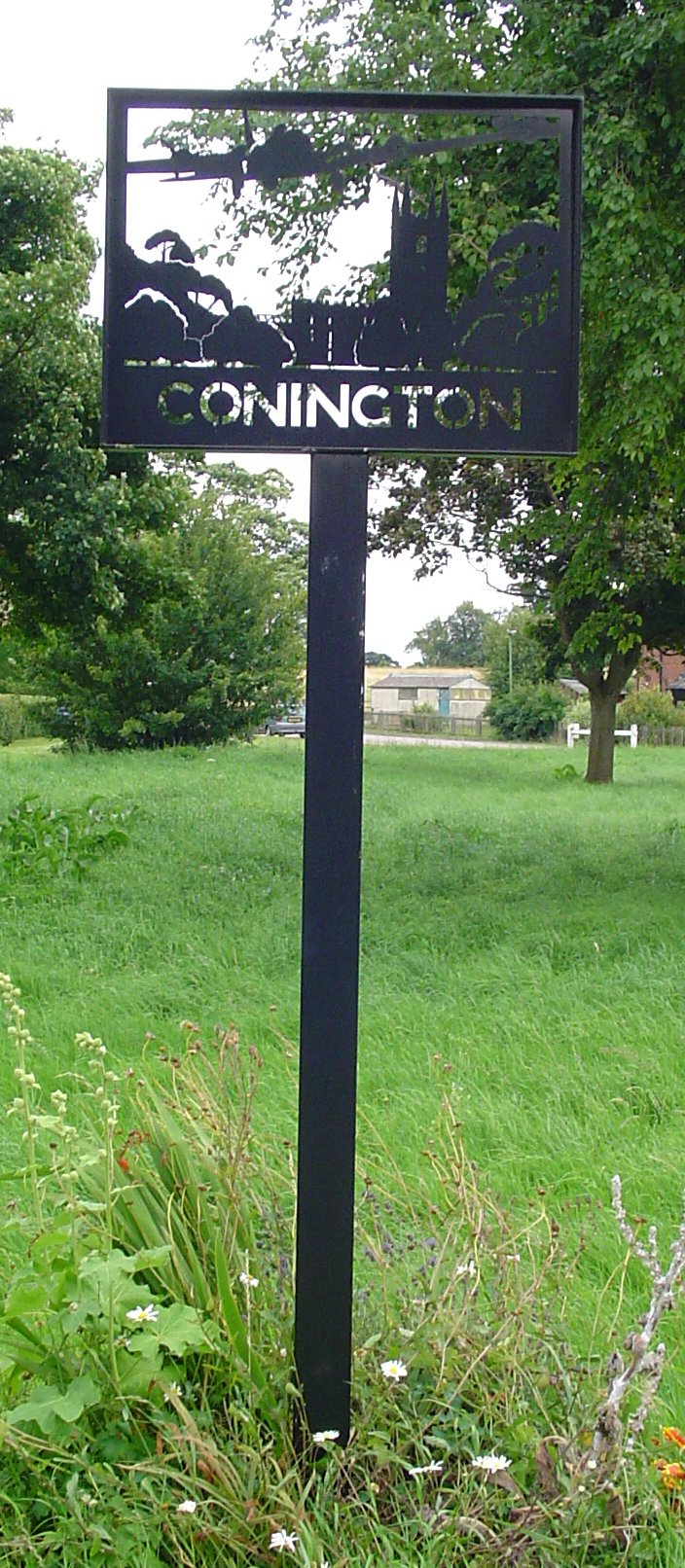
Conington, Huntingdonshire

Conington (Conington All Saints, or "Conington-juxta-Petriburg") is an English village and civil parish in the Cambridgeshire district of Huntingdonshire...

Have you been to Darby Bushes?

Leave your review of Darby Bushes below (or comments, questions and feedback).