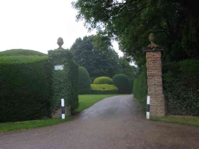
Bill's Wood

Wood, Forest in Hertfordshire St. Albans

England

Bill's Wood

The Green Man, Sandridge
The Green Man, Sandridge Credit: David Howard

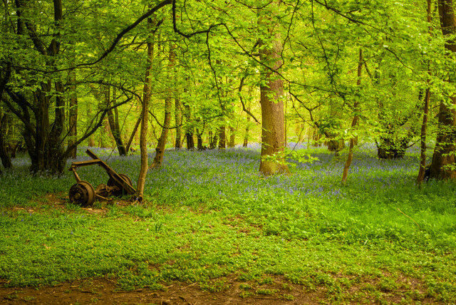
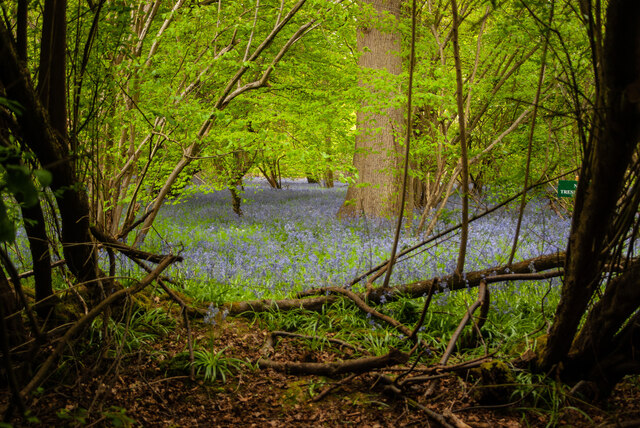
Bill's Wood is a charming woodland located in Hertfordshire, England. Covering an area of approximately 100 acres, this enchanting forest is a haven for nature enthusiasts and outdoor lovers alike. It is situated near the village of Hertford and is easily accessible from nearby towns and cities.

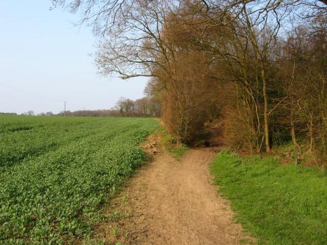
The wood boasts a diverse range of tree species, including oak, beech, and birch, which create a captivating and picturesque landscape. The canopies of these majestic trees provide a serene and peaceful atmosphere, making it an ideal destination for those seeking tranquility and a break from the hustle and bustle of everyday life.

Bill's Wood is home to an abundance of wildlife, including deer, foxes, and a variety of bird species. Nature enthusiasts can explore the forest's well-maintained trails, which wind through the woodland and provide opportunities for fantastic birdwatching and wildlife spotting.

The wood offers a range of recreational activities, such as hiking, cycling, and picnicking. Families can enjoy leisurely walks along the designated paths, while more adventurous visitors can venture off the beaten track to discover hidden gems within the wood.

In addition to its natural beauty, Bill's Wood also has historical significance. It is believed to have been part of an ancient forest that once covered much of Hertfordshire. Remnants of old boundaries and ancient earthworks can still be found within the wood, offering glimpses into its rich past.

Overall, Bill's Wood is a captivating destination that offers a perfect blend of natural beauty, recreational activities, and historical significance. It is an idyllic retreat for individuals and families seeking to immerse themselves in the wonders of nature.

If you have any feedback on the listing, please let us know in the comments section below.

Bill's Wood Images

Images are sourced within 2km of 51.776127/-0.30380322 or Grid Reference TL1709. Thanks to Geograph Open Source API. All images are credited.

The Green Man, Sandridge
High Street, Sandridge
Sandridge : Heartwood Forest
Sandridge : Heartwood Forest bluebells
Sandridge : "Green Man" public house
Sandridge : village shop Grade II listed - <span class="nowrap"><a title="https://historicengland.org.uk/listing/the-list/list-entry/1308275?section=official-list-entry" rel="nofollow ugc noopener" href="https://historicengland.org.uk/listing/the-list/list-entry/1308275?section=official-list-entry">Link</a><img style="margin-left:2px;" alt="External link" title="External link - shift click to open in new window" src="https://s1.geograph.org.uk/img/external.png" width="10" height="10"/></span>.
Sandridge : village shop
Grade II listed - LinkExternal link.
Sandridge : "Queens Head" public house Grade II listed - <span class="nowrap"><a title="https://historicengland.org.uk/listing/the-list/list-entry/1102874?section=official-list-entry" rel="nofollow ugc noopener" href="https://historicengland.org.uk/listing/the-list/list-entry/1102874?section=official-list-entry">Link</a><img style="margin-left:2px;" alt="External link" title="External link - shift click to open in new window" src="https://s1.geograph.org.uk/img/external.png" width="10" height="10"/></span>.
Sandridge : "Queens Head" public house
Grade II listed - LinkExternal link.
Sandridge : Queens Head and flag
Sandridge : Church of St Leonard Grade II* listed church : description at this <span class="nowrap"><a title="https://historicengland.org.uk/listing/the-list/list-entry/1308298?section=official-list-entry" rel="nofollow ugc noopener" href="https://historicengland.org.uk/listing/the-list/list-entry/1308298?section=official-list-entry">Link</a><img style="margin-left:2px;" alt="External link" title="External link - shift click to open in new window" src="https://s1.geograph.org.uk/img/external.png" width="10" height="10"/></span>.
Sandridge : Church of St Leonard
Grade II* listed church : description at this LinkExternal link.
Sandridge : lych-gate to Church of St Leonard "Built 1920, dedicated as a war memorial 1921" - <span class="nowrap"><a title="https://historicengland.org.uk/listing/the-list/list-entry/1102872?section=official-list-entry" rel="nofollow ugc noopener" href="https://historicengland.org.uk/listing/the-list/list-entry/1102872?section=official-list-entry">Link</a><img style="margin-left:2px;" alt="External link" title="External link - shift click to open in new window" src="https://s1.geograph.org.uk/img/external.png" width="10" height="10"/></span>.
Sandridge : lych-gate to Church of St Leonard
"Built 1920, dedicated as a war memorial 1921" - LinkExternal link.
St Leonard's church, Sandridge Looking East from TL171106 to St Leonard's church (with a steeple).
St Leonard's church, Sandridge
Looking East from TL171106 to St Leonard's church (with a steeple).
Signal mast Looking E to the signal mast at TL184103.
Signal mast
Looking E to the signal mast at TL184103.
Signal mast and razor wire Looking almost straight into the sun from TL185104 at the signal mast on the road coming east out of Sandridge.
No normal phone mast this; the thing's ringed with two layers of razor wire fence and has a sign at the entrance with a royal coat of arms on it. Photo notes: for better results take photo in morning, not afternoon like I did - the mast's partially obscured by trees from the west, so better to be east of it with the sun behind you.
Signal mast and razor wire
Looking almost straight into the sun from TL185104 at the signal mast on the road coming east out of Sandridge. No normal phone mast this; the thing's ringed with two layers of razor wire fence and has a sign at the entrance with a royal coat of arms on it. Photo notes: for better results take photo in morning, not afternoon like I did - the mast's partially obscured by trees from the west, so better to be east of it with the sun behind you.
Fork in the path Looking North from TL188105, the path forking right into Symondshyde Great Wood
Fork in the path
Looking North from TL188105, the path forking right into Symondshyde Great Wood
New Dutch Barn workshops Fairfolds Farm This is obviously a farm refurbished as business premises
New Dutch Barn workshops Fairfolds Farm
This is obviously a farm refurbished as business premises
Fairshot Court in Woodcockhill Sandridge The gates were shut and barred but with no fence alongside the gate posts.
Fairshot Court in Woodcockhill Sandridge
The gates were shut and barred but with no fence alongside the gate posts.
Entrance gates, Sandridgebury Entrance gate on the lane leading to Sandridgebury Farm, though not the entrance to the farm.
Entrance gates, Sandridgebury
Entrance gate on the lane leading to Sandridgebury Farm, though not the entrance to the farm.
Farmhouse at Hammonds Farm Nr Coleman Green This is a fine Victorian building with much dignity
Farmhouse at Hammonds Farm Nr Coleman Green
This is a fine Victorian building with much dignity
Show me another place!

Bill's Wood is located at Grid Ref: TL1709 (Lat: 51.776127, Lng: -0.30380322)

Administrative County: Hertfordshire

District: St. Albans

Police Authority: Hertfordshire

What 3 Words

///city.splash.stews. Near St Albans, Hertfordshire

Related Wikis

Sandridge

Sandridge is a village and civil parish between the city centre of St Albans (2.5 miles (4.0 km) to the south-west) and Wheathampstead in Hertfordshire...

Sandridge Rovers F.C.

Sandridge Rovers Football Club is an English football club based in Sandridge, Hertfordshire. They currently compete in the Herts County League Premier...

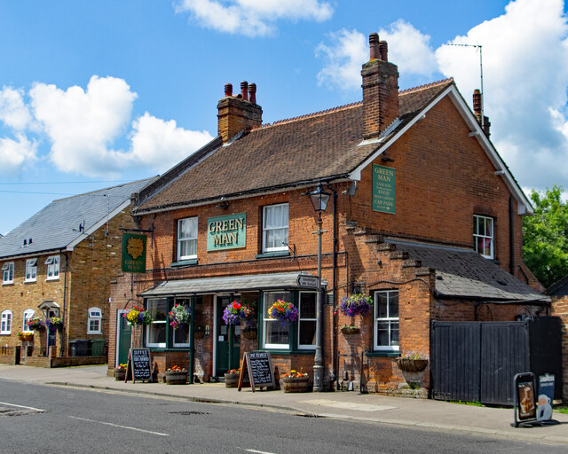
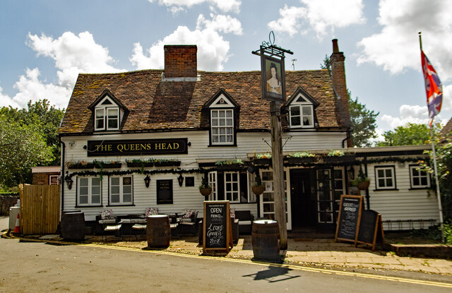
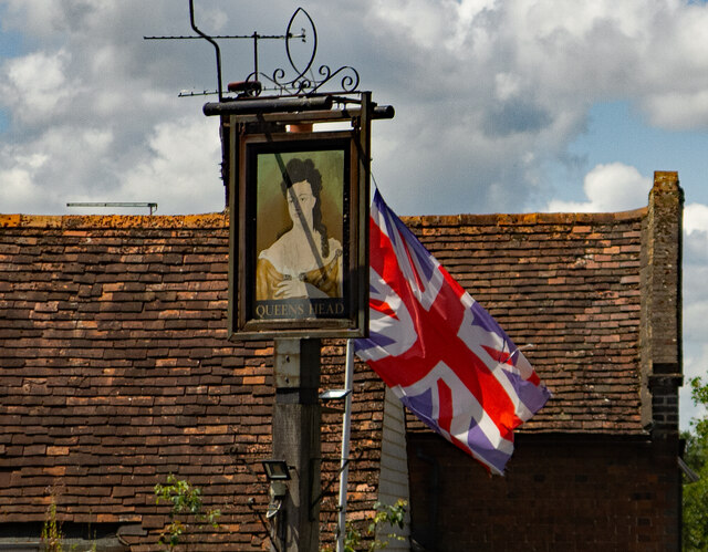
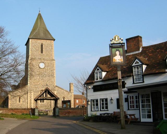
The Queen's Head, Sandridge

The Queens Head is a public house in the village of Sandridge to the north of St Albans, Hertfordshire, England. The timber framed building is weather...

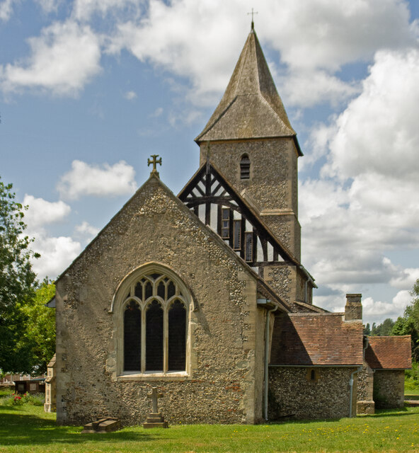
St Leonard's Church, Sandridge

St Leonard's Church is in Sandridge, a village in Hertfordshire, England. It is an active Anglican parish church. The building is Grade II* listed: notable...
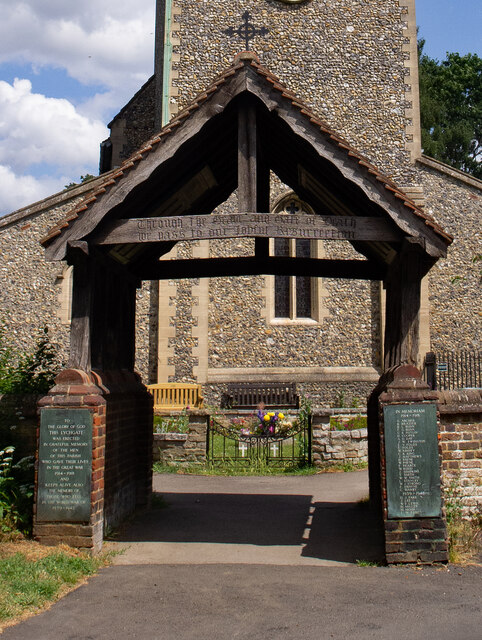
Sandridge Lychgate

Sandridge Lychgate is a war memorial in the village of Sandridge, Hertfordshire, England. The timber lychgate with its flanking walls is listed Grade II...

Sandringham School

Sandringham School is a secondary school with academy status in Marshalswick, St Albans, Hertfordshire. It was established in 1988 following a merger of...

Jersey Farm

Jersey Farm is a residential neighbourhood in the civil parish of Sandridge centred 1.5 miles (2.4 km) north-east of the city centre of St Albans. It is...

Marshalswick

Marshalswick is a suburb of St Albans in Hertfordshire, England, located around 1.5 miles northeast of the city centre. The area was developed from the...

Nearby Amenities

Located within 500m of 51.776127,-0.30380322
Crossing
Crossing: zebra
Crossing Island: no
Tactile Paving: yes
Lat/Long: 51.7799419/-0.3063277
Created By: YahooApplet 1.0
Lat/Long: 51.7790463/-0.2991458
Crossing
Crossing: unmarked
Crossing Island: no
Tactile Paving: yes
Lat/Long: 51.7731609/-0.2999713
Turning Circle
Lat/Long: 51.7785635/-0.3058618
Crossing
Crossing: zebra
Crossing Island: no
Kerb: lowered
Tactile Paving: yes
Lat/Long: 51.7724089/-0.3048362
Bus Stop
Village Hall
Bus: yes
Naptan AtcoCode: 210021501720
Naptan Bearing: SW
Naptan CommonName: Village Hall
Naptan Crossing: opp Hopkins Crescent
Naptan Indicator: opp
Naptan Landmark: opp Hopkins Crescent
Naptan NaptanCode: hrtdagdm
Naptan PlusbusZoneRef: STALBCY
Naptan ShortCommonName: NA
Naptan Street: St Albans Road
Naptan Verified: no
Public Transport: platform
Source: naptan_import
Lat/Long: 51.7788686/-0.3072907
Bus Stop
Reynolds Crescent
Bus: yes
Naptan AtcoCode: 210021501740
Naptan Bearing: SW
Naptan CommonName: Reynolds Crescent
Naptan Crossing: opp Great Barn Dell
Naptan Indicator: adj
Naptan Landmark: opp Great Barn Dell
Naptan NaptanCode: hrtdagdp
Naptan PlusbusZoneRef: STALBCY
Naptan ShortCommonName: NA
Naptan Street: St Albans Road
Naptan Verified: no
Public Transport: platform
Source: naptan_import
Lat/Long: 51.7767151/-0.3100491
Bus Stop
Wilstone Drive
Bus: yes
Local Ref: NR
Naptan AtcoCode: 210021501900
Naptan Bearing: W
Naptan CommonName: Wilstone Drive
Naptan Crossing: opp Highview Gardens
Naptan Indicator: nr
Naptan Landmark: opp Highview Gardens
Naptan NaptanCode: hrtdadwp
Naptan PlusbusZoneRef: STALBCY
Naptan ShortCommonName: NA
Naptan Street: Sandringham Crescent
Naptan Verified: no
Public Transport: platform
Shelter: yes
Source: naptan_import
Lat/Long: 51.7733149/-0.3011262
Bus Stop
Wilstone Drive
Bus: yes
Naptan AtcoCode: 210021509880
Naptan Bearing: E
Naptan CommonName: Wilstone Drive
Naptan Crossing: Belsize Close
Naptan Indicator: opp
Naptan Landmark: Belsize Close
Naptan NaptanCode: hrtatmtm
Naptan PlusbusZoneRef: STALBCY
Naptan ShortCommonName: NA
Naptan Street: Sandringham Crescent
Naptan Verified: no
Public Transport: platform
Shelter: no
Source: naptan_import
Lat/Long: 51.7732801/-0.3005756
Bus Stop
Reynolds Crescent
Bus: yes
Naptan AtcoCode: 210021510020
Naptan Bearing: NE
Naptan CommonName: Reynolds Crescent
Naptan Crossing: Great Barn Dell
Naptan Indicator: opp
Naptan Landmark: Great Barn Dell
Naptan NaptanCode: hrtatmjw
Naptan PlusbusZoneRef: STALBCY
Naptan ShortCommonName: NA
Naptan Street: St Albans Road
Naptan Verified: no
Public Transport: platform
Source: naptan_import
Lat/Long: 51.77652/-0.3104867
Bus Stop
Village Hall
Bus: yes
Naptan AtcoCode: 210021510040
Naptan Bearing: NE
Naptan CommonName: Village Hall
Naptan Crossing: Hopkins Crescent
Naptan Indicator: nr
Naptan Landmark: Hopkins Crescent
Naptan NaptanCode: hrtatmpa
Naptan PlusbusZoneRef: STALBCY
Naptan ShortCommonName: NA
Naptan Street: St Albans Road
Naptan Verified: no
Public Transport: platform
Source: naptan_import
Lat/Long: 51.7794576/-0.3068892
Burma Star Association Memorial
Historic: memorial
Material: stone
Memorial: stele
Lat/Long: 51.773232/-0.3043633
Crossing
Bicycle: yes
Crossing: unmarked
Lat/Long: 51.7727644/-0.2990612
Crossing
Crossing Signals: no
Lat/Long: 51.7727402/-0.3079689
Crossing
Crossing Island: yes
Crossing Markings: no
Crossing Signals: no
Tactile Paving: yes
Lat/Long: 51.7728474/-0.304092
Post Box
Collection Times: Mo-Fr 09:00; Sa 07:00
Post Box Type: lamp
Ref: AL4 200
Royal Cypher: EIIR
Royal Cypher Wikidata: Q33102113
Lat/Long: 51.7787594/-0.2992008
Crossing
Crossing: unmarked
Crossing Island: yes
Tactile Paving: no
Lat/Long: 51.7726598/-0.3054103
Material: wood
Power: pole
Lat/Long: 51.7779525/-0.2975911
Sandridge Sports & Youth Centre
Leisure: sports_centre
Lat/Long: 51.779649/-0.3079923
Recycling
Recycling Type: container
Lat/Long: 51.7800638/-0.3072303
Shop: car
Lat/Long: 51.7803313/-0.3056995
Direction: 170
Fixme: survey for panel count
Generator Method: photovoltaic
Generator Output Electricity: yes
Generator Solar Modules: 6
Generator Source: solar
Generator Type: solar_photovoltaic_panel
Location: roof
Power: generator
Lat/Long: 51.7737848/-0.2990675
Direction: 230
Generator Method: photovoltaic
Generator Output Electricity: yes
Generator Solar Modules: 16
Generator Source: solar
Generator Type: solar_photovoltaic_panel
Location: roof
Power: generator
Lat/Long: 51.7738486/-0.299582
Direction: 170
Generator Method: photovoltaic
Generator Output Electricity: yes
Generator Solar Modules: 16
Generator Source: solar
Generator Type: solar_photovoltaic_panel
Location: roof
Power: generator
Lat/Long: 51.7748003/-0.2990456
Direction: 220
Fixme: survey: additional panels - thermal?
Generator Method: photovoltaic
Generator Output Electricity: yes
Generator Solar Modules: 8
Generator Source: solar
Generator Type: solar_photovoltaic_panel
Location: roof
Power: generator
Lat/Long: 51.7743712/-0.2996695
Bench
Backrest: yes
Colour: black;brown
Lat/Long: 51.7755354/-0.3092239
Bench
Backrest: no
Lat/Long: 51.7757107/-0.3053306
Bench
Backrest: no
Lat/Long: 51.7757211/-0.3052457
Bench
Backrest: yes
Lat/Long: 51.775594/-0.3036777
Bench
Backrest: yes
Lat/Long: 51.7757588/-0.3039317
Bench
Backrest: yes
Lat/Long: 51.776047/-0.304409
Fixme: solar panels?
Lat/Long: 51.7747566/-0.2982601
Direction: 125
Generator Method: photovoltaic
Generator Output Electricity: yes
Generator Solar Modules: 11
Generator Source: solar
Generator Type: solar_photovoltaic_panel
Location: roof
Power: generator
Lat/Long: 51.775812/-0.310703
Direction: 215
Generator Method: photovoltaic
Generator Output Electricity: yes
Generator Solar Modules: 8
Generator Source: solar
Generator Type: solar_photovoltaic_panel
Location: roof
Power: generator
Lat/Long: 51.7762963/-0.3098878
Direction: 305
Generator Method: photovoltaic
Generator Output Electricity: yes
Generator Solar Modules: 4
Generator Source: solar
Generator Type: solar_photovoltaic_panel
Location: roof
Power: generator
Lat/Long: 51.7763253/-0.3099193
Direction: 220
Generator Method: photovoltaic
Generator Output Electricity: yes
Generator Solar Modules: 12
Generator Source: solar
Generator Type: solar_photovoltaic_panel
Location: roof
Power: generator
Lat/Long: 51.7779403/-0.3076046
Direction: 220
Generator Method: photovoltaic
Generator Output Electricity: yes
Generator Solar Modules: 7
Generator Source: solar
Generator Type: solar_photovoltaic_panel
Location: roof
Power: generator
Lat/Long: 51.7781219/-0.3060566
Direction: 40
Generator Method: photovoltaic
Generator Output Electricity: yes
Generator Solar Modules: 9
Generator Source: solar
Generator Type: solar_photovoltaic_panel
Location: roof
Power: generator
Lat/Long: 51.7781389/-0.3060312
Direction: 175
Generator Method: photovoltaic
Generator Output Electricity: yes
Generator Solar Modules: 6
Generator Source: solar
Generator Type: solar_photovoltaic_panel
Location: roof
Power: generator
Lat/Long: 51.7785544/-0.3054922
Direction: 130
Generator Method: photovoltaic
Generator Output Electricity: yes
Generator Solar Modules: 10
Generator Source: solar
Generator Type: solar_photovoltaic_panel
Location: roof
Power: generator
Lat/Long: 51.7790208/-0.3054431
Direction: 210
Generator Method: photovoltaic
Generator Output Electricity: yes
Generator Solar Modules: 18
Generator Source: solar
Generator Type: solar_photovoltaic_panel
Location: roof
Power: generator
Lat/Long: 51.7797296/-0.3040734
Crossing
Lat/Long: 51.7726638/-0.3062467
Leisure: picnic_table
Lat/Long: 51.7767713/-0.3050946
The data included in this document is from www.openstreetmap.org. The data is made available under ODbL.

Have you been to Bill's Wood?

Leave your review of Bill's Wood below (or comments, questions and feedback).