Honey Grove

Wood, Forest in Sussex Horsham

England

Honey Grove

Basing Wood A lone oak stands guard over an army of firs. Taken from North Lane bridleway just north of Coombelands.
Basing Wood Credit: Simon Carey

Honey Grove is a charming village located in the beautiful countryside of Sussex, England. Nestled within a lush woodland area, it is known for its scenic landscapes and serene atmosphere. The village is situated near the larger town of Wood and is surrounded by an enchanting forest that adds to its natural appeal.

The village itself is small yet picturesque, with traditional cottages and well-kept gardens lining its streets. Honey Grove has managed to retain its historic character, with many of its buildings dating back several centuries. The local community takes pride in preserving the village's heritage, evident in the well-maintained architecture and the warm welcome visitors receive.

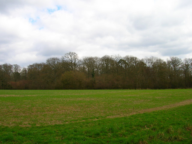
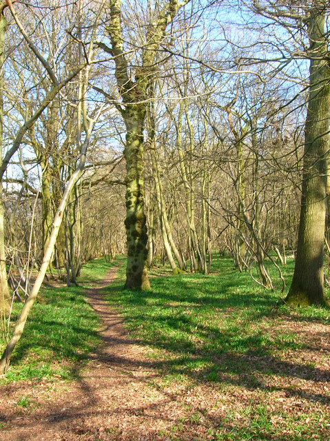
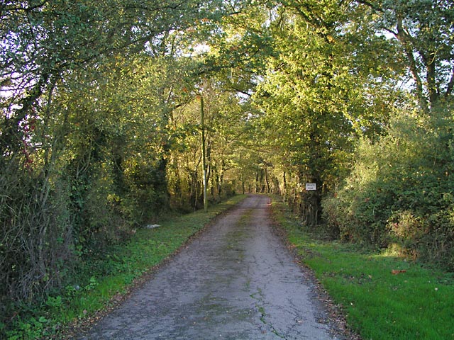
Nature lovers and outdoor enthusiasts are drawn to Honey Grove for its proximity to the forest. The woodland offers an abundance of walking trails, allowing visitors to explore the area's natural beauty and observe the local flora and fauna. The forest is particularly popular during the autumn months when its vibrant colors attract photographers and nature enthusiasts alike.

The village has a strong sense of community, with various events and gatherings throughout the year. The annual Honey Festival, held in the summer, is a highlight for both locals and tourists. This vibrant event celebrates the area's rich history of honey production, offering visitors the opportunity to sample local honey and immerse themselves in the village's culture.

Honey Grove is a tranquil retreat that offers a peaceful escape from the hustle and bustle of city life. With its idyllic setting, historic charm, and proximity to nature, it is a destination that appeals to those seeking a relaxing and authentic experience in the heart of Sussex.

If you have any feedback on the listing, please let us know in the comments section below.

Honey Grove Images

Images are sourced within 2km of 50.945151/-0.34820358 or Grid Reference TQ1617. Thanks to Geograph Open Source API. All images are credited.

Basing Wood A lone oak stands guard over an army of firs. Taken from North Lane bridleway just north of Coombelands.
Basing Wood
A lone oak stands guard over an army of firs. Taken from North Lane bridleway just north of Coombelands.
Capite Wood Taken from the footpath that links Woodman's Farm with Buckells Farm. The dense cover of the firs gives it a spooky feel.
Capite Wood
Taken from the footpath that links Woodman's Farm with Buckells Farm. The dense cover of the firs gives it a spooky feel.
Footbridge, Capite Wood Carrying the footpath that links Woodman's Farm to Buckells Farm
Footbridge, Capite Wood
Carrying the footpath that links Woodman's Farm to Buckells Farm
Field near Dalesdown School Chanctonbury Ring can be seen between the two trees to the right just above the less than bucolic flytipping area. Taken from the point where the footpath crosses the farm road.
Field near Dalesdown School
Chanctonbury Ring can be seen between the two trees to the right just above the less than bucolic flytipping area. Taken from the point where the footpath crosses the farm road.
Pot Common Potcommon Furzefield to the left, Soil Wood to the right. Taken from the bridleway.
Pot Common
Potcommon Furzefield to the left, Soil Wood to the right. Taken from the bridleway.
Smiley Face, Honeybridge Lane Painted sign next to the entrance of Dalesdown Educational Establishment.
Smiley Face, Honeybridge Lane
Painted sign next to the entrance of Dalesdown Educational Establishment.
Flat Dossers Known a few of them in my time! Taken from the bridleway.
Flat Dossers
Known a few of them in my time! Taken from the bridleway.
Entrance to Whitefoots Wheelie bin standing guard. This is the point where the bridleway turns shapely west.
Entrance to Whitefoots
Wheelie bin standing guard. This is the point where the bridleway turns shapely west.
Grinders Wood Taken from the footpath that links Thistleworth Farm with Buckells Farm.
Grinders Wood
Taken from the footpath that links Thistleworth Farm with Buckells Farm.
Outbuildings, Honeybridge Farm Known as Starkers Farm on the 1940s map. Taken from the footpath that links Daylands Farm with Kings Barn Farm.
Outbuildings, Honeybridge Farm
Known as Starkers Farm on the 1940s map. Taken from the footpath that links Daylands Farm with Kings Barn Farm.
Field, Jessops Farm Taken from the footpath that goes through the farm.
Field, Jessops Farm
Taken from the footpath that goes through the farm.
Footpath, Jack O'Lantern Wood This is one of the better ones too!
Footpath, Jack O'Lantern Wood
This is one of the better ones too!
The route to Hawking Sopers Common Copse is to the right and those rainclouds were heading my way.
The route to Hawking Sopers
Common Copse is to the right and those rainclouds were heading my way.
Dying Deer, near Jessops Farm On the footpath that heads south from the farm. Both back legs seemed to be gone. Not much I could do I'm afraid.
Dying Deer, near Jessops Farm
On the footpath that heads south from the farm. Both back legs seemed to be gone. Not much I could do I'm afraid.
Entrance to Perrylands Seen from the A24.
Entrance to Perrylands
Seen from the A24.
Signpost, Church Lane, Ashurst Taken from the junction of School Lane and Pepper Lane. The road ahead leads to the parish church then heads back to the B2135.
Signpost, Church Lane, Ashurst
Taken from the junction of School Lane and Pepper Lane. The road ahead leads to the parish church then heads back to the B2135.
St James' Church, Ashurst Begun in late 1200 and rebuilt during Victorian times. The church is to the north west of the village.
St James' Church, Ashurst
Begun in late 1200 and rebuilt during Victorian times. The church is to the north west of the village.
Ford Clappers The name indicates the possible existence of a ford in the past perhaps using laid stones. Today this tributary of the western Adur is crossed by a footbridge.
Ford Clappers
The name indicates the possible existence of a ford in the past perhaps using laid stones. Today this tributary of the western Adur is crossed by a footbridge.
Show me another place!

Honey Grove is located at Grid Ref: TQ1617 (Lat: 50.945151, Lng: -0.34820358)

Administrative County: West Sussex

District: Horsham

Police Authority: Sussex

What 3 Words

///shaped.trapdoor.nest. Near Ashurst, West Sussex

Related Wikis

St James's Church, Ashurst

St James's Church is a Church of England parish church in Ashurst, West Sussex. The church is a grade I listed building and it dates from the early 12th...

Dial Post

Dial Post is a village in the Horsham District of West Sussex, England. The civil parish, where the lowest level political meetings are held, is West Grinstead...

Ashurst, West Sussex

Ashurst is a village and civil parish in the Horsham District of West Sussex, England, about 2 miles (3.2 km) west of Henfield, and 11 miles (18 km) south...

Fountain Inn, Ashurst

The Fountain Inn is a 16th-century public house in the village of Ashurst, in the Horsham district of West Sussex, England. After a period as a farmhouse...

Nearby Amenities

Located within 500m of 50.945151,-0.34820358
Power: pole
Lat/Long: 50.9490094/-0.3499894
Post Box
Collection Times: Mo-Fr 16:30; Sa 08:15
Operator: Royal Mail
Post Box Mounting: pier
Post Box Type: lamp
Ref: RH12 64
Royal Cypher: EIIR
Royal Cypher Wikidata: Q33102113
Lat/Long: 50.9472377/-0.352504
Power: pole
Lat/Long: 50.9441795/-0.3432464
Power: pole
Lat/Long: 50.9441239/-0.3432879
Power: pole
Lat/Long: 50.9437904/-0.3416712
Power: pole
Lat/Long: 50.9437201/-0.3416816
Location Transition: yes
Power: pole
Lat/Long: 50.9455528/-0.3505218
Power: pole
Lat/Long: 50.945372/-0.349575
Power: pole
Lat/Long: 50.9451066/-0.3482017
Power: pole
Lat/Long: 50.9448413/-0.3467721
Power: pole
Lat/Long: 50.9446487/-0.3456885
Power: pole
Lat/Long: 50.9444306/-0.3445378
Location Transition: yes
Power: pole
Lat/Long: 50.9454827/-0.3505473
Power: pole
Lat/Long: 50.9453001/-0.3496166
Power: pole
Lat/Long: 50.9450441/-0.3482218
Power: pole
Lat/Long: 50.9445489/-0.3456563
Power: pole
Lat/Long: 50.9443538/-0.3445324
The Capite
Place: hamlet
Lat/Long: 50.948006/-0.3476886
Leisure: firepit
Lat/Long: 50.9478941/-0.3445926
Eder Farm
Place: farm
Lat/Long: 50.9494583/-0.3492585
Fountain
Lat/Long: 50.9481899/-0.3491446
Buckells Farm
Place: farm
Lat/Long: 50.9467461/-0.3520848
The data included in this document is from www.openstreetmap.org. The data is made available under ODbL.

Have you been to Honey Grove?

Leave your review of Honey Grove below (or comments, questions and feedback).