Long Spring

Wood, Forest in Hertfordshire St. Albans

England

Long Spring

The Green Man, Sandridge
The Green Man, Sandridge Credit: David Howard

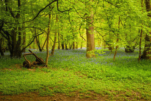
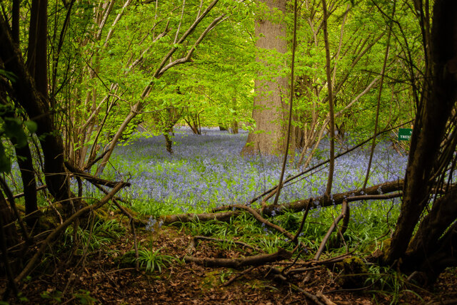
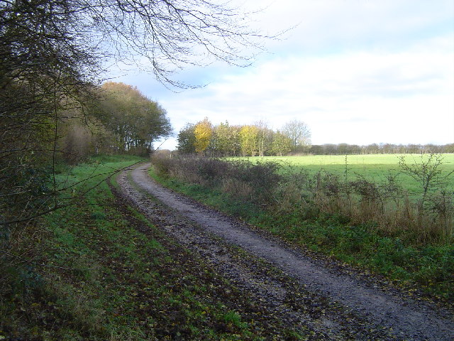
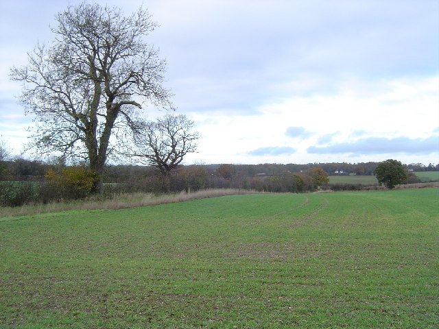
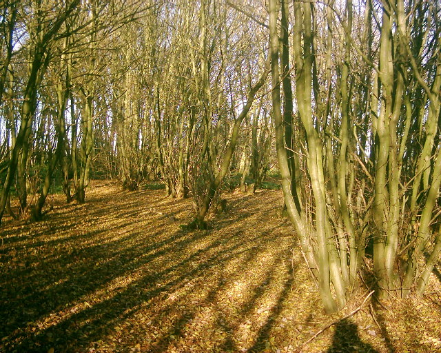
Long Spring is a picturesque woodland area located in the county of Hertfordshire, England. Situated within the broader region of Wood, Forest, this natural haven spans approximately 300 acres and is known for its breathtaking beauty and abundant wildlife.

The woodlands of Long Spring are predominantly composed of deciduous trees, creating a vibrant and ever-changing landscape throughout the seasons. Ancient oak, beech, and birch trees dominate the area, their towering canopies providing shade and shelter for a diverse range of flora and fauna.

The forest floor is adorned with a rich carpet of bluebells, wild garlic, and ferns, creating a magical atmosphere during springtime. The area is also home to a variety of woodland animals, including deer, foxes, badgers, and a multitude of bird species.

Long Spring offers a network of well-maintained trails, enabling visitors to explore the woodlands on foot or by bicycle. The paths meander through the trees, leading to hidden glades, tranquil ponds, and enchanting clearings, providing ample opportunities for nature lovers and photographers.

Furthermore, the woodlands of Long Spring are actively managed to maintain their ecological balance and preserve the natural habitat. Conservation efforts aim to protect rare and endangered species, maintain the health of the woodland ecosystem, and promote sustainable practices.

Overall, Long Spring in Hertfordshire is a captivating woodland area that offers a serene escape from the hustle and bustle of everyday life. Its natural beauty, diverse wildlife, and well-maintained trails make it a cherished destination for nature enthusiasts and those seeking a peaceful retreat in the heart of Wood, Forest.

If you have any feedback on the listing, please let us know in the comments section below.

Long Spring Images

Images are sourced within 2km of 51.772827/-0.32636416 or Grid Reference TL1509. Thanks to Geograph Open Source API. All images are credited.

The Green Man, Sandridge
High Street, Sandridge
Sandridge : Heartwood Forest
Sandridge : Heartwood Forest bluebells
Sandridge : "Green Man" public house
Sandridge : village shop Grade II listed - <span class="nowrap"><a title="https://historicengland.org.uk/listing/the-list/list-entry/1308275?section=official-list-entry" rel="nofollow ugc noopener" href="https://historicengland.org.uk/listing/the-list/list-entry/1308275?section=official-list-entry">Link</a><img style="margin-left:2px;" alt="External link" title="External link - shift click to open in new window" src="https://s1.geograph.org.uk/img/external.png" width="10" height="10"/></span>.
Sandridge : village shop
Grade II listed - LinkExternal link.
Sandridge : "Queens Head" public house Grade II listed - <span class="nowrap"><a title="https://historicengland.org.uk/listing/the-list/list-entry/1102874?section=official-list-entry" rel="nofollow ugc noopener" href="https://historicengland.org.uk/listing/the-list/list-entry/1102874?section=official-list-entry">Link</a><img style="margin-left:2px;" alt="External link" title="External link - shift click to open in new window" src="https://s1.geograph.org.uk/img/external.png" width="10" height="10"/></span>.
Sandridge : "Queens Head" public house
Grade II listed - LinkExternal link.
Sandridge : Queens Head and flag
Sandridge : Church of St Leonard Grade II* listed church : description at this <span class="nowrap"><a title="https://historicengland.org.uk/listing/the-list/list-entry/1308298?section=official-list-entry" rel="nofollow ugc noopener" href="https://historicengland.org.uk/listing/the-list/list-entry/1308298?section=official-list-entry">Link</a><img style="margin-left:2px;" alt="External link" title="External link - shift click to open in new window" src="https://s1.geograph.org.uk/img/external.png" width="10" height="10"/></span>.
Sandridge : Church of St Leonard
Grade II* listed church : description at this LinkExternal link.
Sandridge : lych-gate to Church of St Leonard "Built 1920, dedicated as a war memorial 1921" - <span class="nowrap"><a title="https://historicengland.org.uk/listing/the-list/list-entry/1102872?section=official-list-entry" rel="nofollow ugc noopener" href="https://historicengland.org.uk/listing/the-list/list-entry/1102872?section=official-list-entry">Link</a><img style="margin-left:2px;" alt="External link" title="External link - shift click to open in new window" src="https://s1.geograph.org.uk/img/external.png" width="10" height="10"/></span>.
Sandridge : lych-gate to Church of St Leonard
"Built 1920, dedicated as a war memorial 1921" - LinkExternal link.
St Leonard's church, Sandridge Looking East from TL171106 to St Leonard's church (with a steeple).
St Leonard's church, Sandridge
Looking East from TL171106 to St Leonard's church (with a steeple).
Entrance gates, Sandridgebury Entrance gate on the lane leading to Sandridgebury Farm, though not the entrance to the farm.
Entrance gates, Sandridgebury
Entrance gate on the lane leading to Sandridgebury Farm, though not the entrance to the farm.
Sandridge: Bridleway The bridleway from Sandridge to Ayres End Lane viewed looking north westwards with the coppiced hornbeam Langley Wood to the left.
Sandridge: Bridleway
The bridleway from Sandridge to Ayres End Lane viewed looking north westwards with the coppiced hornbeam Langley Wood to the left.
Sandridge: Well Wood Viewed looking northwards with Well Wood to the left, the landowner has, as part of the Countryside Stewardship scheme, kindly granted permissive footpaths along the field edges, and this is one of them.
Sandridge: Well Wood
Viewed looking northwards with Well Wood to the left, the landowner has, as part of the Countryside Stewardship scheme, kindly granted permissive footpaths along the field edges, and this is one of them.
Railway line between St Albans and Harpenden Viewed looking southwards from Cheapside Farm bridge, a northbound Thameslink train approaches. This is the main railway line from London to Luton, Bedford, Kettering, Leicester, and Nottingham.
Railway line between St Albans and Harpenden
Viewed looking southwards from Cheapside Farm bridge, a northbound Thameslink train approaches. This is the main railway line from London to Luton, Bedford, Kettering, Leicester, and Nottingham.
Farmland twixt St Albans and Harpenden Viewed looking northwards from the track to Cheapside Farm.
Farmland twixt St Albans and Harpenden
Viewed looking northwards from the track to Cheapside Farm.
Childwickbury Manor House Childwickbury manor, formerly Stanley Kubrick's house.
Childwickbury Manor House
Childwickbury manor, formerly Stanley Kubrick's house.
Coppicing This is a section of coppice within Langley Wood. The wood is accessible from the adjacent footpath.
Coppicing
This is a section of coppice within Langley Wood. The wood is accessible from the adjacent footpath.
Show me another place!

Long Spring is located at Grid Ref: TL1509 (Lat: 51.772827, Lng: -0.32636416)

Administrative County: Hertfordshire

District: St. Albans

Police Authority: Hertfordshire

What 3 Words

///orbit.clots.sits. Near St Albans, Hertfordshire

Related Wikis

Beech Bottom Dyke

Beech Bottom Dyke, is a large ditch running for almost a mile at the northern edge of St Albans, Hertfordshire flanked by banks on both sides. It is up...

St Albans Girls' School

St Albans Girls' School, usually referred to as STAGS, is a girls' secondary school in St Albans, Hertfordshire. It was formerly known as "St Albans Girls...

A1081 road

The A1081 is a road in the south of England. It starts at Luton Airport in Bedfordshire and runs to High Barnet in Greater London via Harpenden, St Albans...

Townsend Church of England School

Townsend Church of England School is a voluntary aided secondary school based in St Albans, Hertfordshire, England. The students attending are aged between...

St Albans City and District

St Albans (), commonly known as the City and District of St Albans, is a local government district with city status in Hertfordshire, England. Its council...

Sandringham School

Sandringham School is a secondary school with academy status in Marshalswick, St Albans, Hertfordshire. It was established in 1988 following a merger of...

Bernards Heath

Bernards Heath is a heathland in St Albans, Hertfordshire, the site of the Second Battle of St Albans in 1461 during the Wars of the Roses. In the 19th...

Sandridge Rovers F.C.

Sandridge Rovers Football Club is an English football club based in Sandridge, Hertfordshire. They currently compete in the Herts County League Premier...

Nearby Amenities

Located within 500m of 51.772827,-0.32636416
Bicycle Parking
Access: private
Bicycle Parking: stands
Capacity: 40
Covered: yes
Lat/Long: 51.7704309/-0.330678
Communication Mobile Phone: yes
Man Made: mast
Tower Construction: lattice
Tower Type: communication
Lat/Long: 51.7719204/-0.3270159
Barrier: entrance
Lat/Long: 51.7693445/-0.3237956
Barrier: entrance
Lat/Long: 51.7687448/-0.3238351
Barrier: entrance
Lat/Long: 51.7690563/-0.3239539
Barrier: entrance
Lat/Long: 51.7690403/-0.3238282
Barrier: entrance
Lat/Long: 51.7695467/-0.3237697
Barrier: entrance
Lat/Long: 51.7688115/-0.3242605
Barrier: entrance
Lat/Long: 51.7687975/-0.3238352
Barrier: entrance
Lat/Long: 51.7693464/-0.3239325
Twin Systems
Addr City: St Albans
Addr Housename: Cedar Court, Parkway
Addr Postcode: AL3 6PA
Addr Street: Porters Wood
Email: LetsTalk@twinsystems.com
Fixme: refine location
Office: it
Phone: +44 345 3131 483
Website: https://www.twinsystems.com/
Lat/Long: 51.7715023/-0.3259031
Post Box
Brand: Royal Mail
Brand Wikidata: Q638098
Brand Wikipedia: en:Royal Mail
Note: Franked mail only
Operator: Royal Mail
Operator Wikidata: Q638098
Post Box Type: pillar
Ref: AL3 203
Royal Cypher: EIIR
Royal Cypher Wikidata: Q33102113
Lat/Long: 51.7695001/-0.3268145
Post Box
Brand: Royal Mail
Brand Wikidata: Q638098
Brand Wikipedia: en:Royal Mail
Collection Times: Mo-Fr 16:00; Sa 12:00
Operator: Royal Mail
Operator Wikidata: Q638098
Post Box Type: pillar
Ref: AL3 271
Royal Cypher: EIIR
Royal Cypher Wikidata: Q33102113
Lat/Long: 51.7713184/-0.326407
A1 Tools and Fixings
Addr City: St Albans
Addr Housenumber: 29
Addr Postcode: AL3 6PF
Addr Street: Soothouse Spring
Shop: tool_hire
Url: http://a1-tools.co.uk/
Lat/Long: 51.7709877/-0.3245798
Todd Doors
Addr City: St Albans
Addr Housenumber: 28
Addr Postcode: AL3 6PF
Addr Street: Soothouse Spring
Craft: builder
Shop: hardware
Lat/Long: 51.7710769/-0.3243977
Addr Postcode: AL3 6ER
Building: yes
Lat/Long: 51.7738604/-0.3231806
Crossing
Crossing: marked
Lat/Long: 51.770875/-0.3209064
Crossing
Crossing: marked
Lat/Long: 51.7708901/-0.3209992
Barrier: turnstile
Lat/Long: 51.7708359/-0.3208529
Direction: 220
Generator Method: photovoltaic
Generator Output Electricity: yes
Generator Solar Modules: 16
Generator Source: solar
Generator Type: solar_photovoltaic_panel
Location: roof
Power: generator
Lat/Long: 51.7685126/-0.325186
Direction: 205
Generator Method: photovoltaic
Generator Output Electricity: 12
Generator Solar Modules: 7
Generator Source: solar
Generator Type: solar_photovoltaic_panel
Location: roof
Power: generator
Lat/Long: 51.7714004/-0.3324928
Direction: 230
Generator Method: photovoltaic
Generator Output Electricity: yes
Generator Solar Modules: 21
Generator Source: solar
Generator Type: solar_photovoltaic_panel
Location: roof
Power: generator
Tilt: 20
Lat/Long: 51.7711865/-0.3257924
Direction: 140
Generator Method: photovoltaic
Generator Output Electricity: yes
Generator Solar Modules: 73
Generator Source: solar
Generator Type: solar_photovoltaic_panel
Location: roof
Power: generator
Tilt: 20
Lat/Long: 51.7712137/-0.3256429
Direction: both
Surface: asphalt
Traffic Calming: hump
Lat/Long: 51.7691669/-0.3233505
Colour: red
Man Made: street_cabinet
Operator: Royal Mail
Street Cabinet: postal_service
Lat/Long: 51.7687823/-0.3253561
Barrier: entrance
Lat/Long: 51.7687775/-0.3242622
The data included in this document is from www.openstreetmap.org. The data is made available under ODbL.

Have you been to Long Spring?

Leave your review of Long Spring below (or comments, questions and feedback).