The Osiers

Wood, Forest in Hertfordshire St. Albans

England

The Osiers

Dalkeith Road c.1930s housing.
Dalkeith Road Credit: Ian Capper

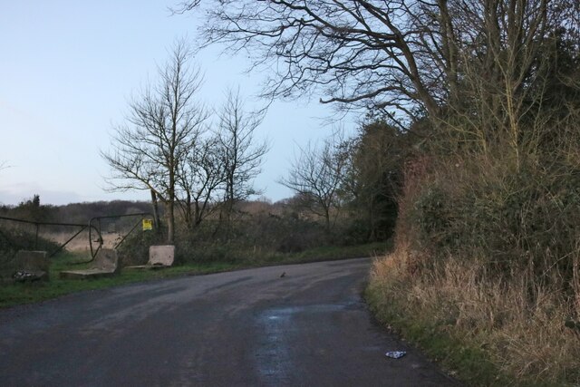
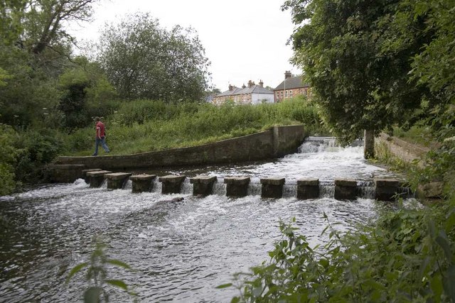
The Osiers is a picturesque woodland located in Hertfordshire, England. Covering an area of approximately 50 acres, it is renowned for its natural beauty and tranquil atmosphere. The woodland is primarily made up of osier trees, which are a type of willow known for their flexible branches, hence the name "The Osiers".

The forest boasts a diverse range of flora and fauna, making it an ideal destination for nature enthusiasts and wildlife lovers. The forest floor is adorned with a carpet of bluebells during the springtime, creating a breathtaking spectacle. Rare species of birds, such as woodpeckers and tawny owls, can often be spotted in the trees, adding to the enchanting ambience of the woodland.

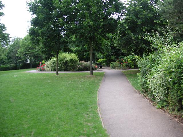
Visitors can explore The Osiers through a network of well-maintained walking trails, which provide access to various parts of the forest. These trails are suitable for all ages and skill levels, offering a wonderful opportunity to immerse oneself in nature and enjoy a peaceful stroll.

The Osiers is not only a haven for wildlife but also offers recreational activities for visitors. Families can enjoy picnics in designated areas or engage in outdoor games amidst the stunning natural backdrop. Furthermore, the woodland is a popular spot for photography enthusiasts, with its captivating scenery providing countless opportunities for capturing stunning shots.

In summary, The Osiers in Hertfordshire is a captivating woodland that showcases the beauty of nature. With its diverse flora and fauna, well-maintained trails, and recreational activities, it offers a serene and enjoyable experience for all who visit.

If you have any feedback on the listing, please let us know in the comments section below.

The Osiers Images

Images are sourced within 2km of 51.832278/-0.35093827 or Grid Reference TL1316. Thanks to Geograph Open Source API. All images are credited.

Dalkeith Road c.1930s housing.
Dalkeith Road
c.1930s housing.
Connaught Road c.1930s housing.
Connaught Road
c.1930s housing.
Junction on Common Lane, Batford
Field in Batford
Field in Batford
Common Lane, Bower Heath
Viaduct Cottages, East Hyde
Chiltern Green Viaduct The second brick line has been replaced by the metal section just crossing the road.
Chiltern Green Viaduct
The second brick line has been replaced by the metal section just crossing the road.
Coldharbour Lane, Harpenden
Batford Road at the junction of Lower Luton Road
Houses on Pickford Hill, Batford
Pickford Hill, Batford
Traffic island on Pickford Hill, Batford
Pickford Hill, Batford
Houses on Finley Road, Batford
Westfield Avenue, Harpenden
Westfield Road, Harpenden The railway is behind the barrier
Westfield Road, Harpenden
The railway is behind the barrier
House on Ox Lane, Harpenden
Show me another place!

The Osiers is located at Grid Ref: TL1316 (Lat: 51.832278, Lng: -0.35093827)

Administrative County: Hertfordshire

District: St. Albans

Police Authority: Hertfordshire

What 3 Words

///dance.whites.flank. Near Harpenden, Hertfordshire

Nearby Locations

Mill Stream The Osiers

Related Wikis

Bower Heath

Bower Heath is a hamlet in Hertfordshire, England. It is in the civil parish of Harpenden

The King's School (Harpenden)

The King's School, Harpenden is a co-educational independent school for pupils aged four to sixteen, located to the north of Harpenden in Hertfordshire...

St George's School, Harpenden

St George's School, Harpenden (also known as St George's) is a non-selective state day and boarding school in Harpenden, Hertfordshire, England, educating...

Sir John Lawes School

Sir John Lawes School (also known as SJL) is a mixed state secondary school with academy status in Harpenden, United Kingdom. The school has close links...

Harpenden East railway station

Harpenden East was one of two stations serving the town of Harpenden, the other station which remains open being Harpenden Central. Originally named Harpenden...

Batford Springs

Batford Springs is a 3.5-hectare (8.6-acre) Local Nature Reserve in Harpenden in Hertfordshire. It is owned and managed by Harpenden Town Council, and...

Lydekker Park

Lydekker Park is a 3-acre (1.2 ha) park in Harpenden, Hertfordshire. The land was formerly part of the garden of Harpenden Lodge, built in 1803, home...

East Hyde

East Hyde is a village in the civil parish of Hyde, in the Central Bedfordshire district, in the ceremonial county of Bedfordshire, England. East Hyde...

Nearby Amenities

Located within 500m of 51.832278,-0.35093827
Mini Roundabout
Direction: clockwise
Lat/Long: 51.8303212/-0.3479785
Direction: backward
Traffic Calming: chicane
Lat/Long: 51.8288618/-0.3510334
Crossing
Crossing: unmarked
Lat/Long: 51.8297792/-0.3487775
Traffic Calming: choker
Lat/Long: 51.8297435/-0.3488577
Turning Circle
Lat/Long: 51.8286299/-0.3498119
Post Box
Collection Times: Mo-Fr 09:00, Sa 07:00
Post Box Mounting: brick_pillar
Post Box Type: wall
Ref: AL5 45D
Royal Cypher: EIIR
Royal Cypher Wikidata: Q33102113
Lat/Long: 51.8285775/-0.3515456
Bus Stop
The Red Cow PH
Bench: no
Bus: yes
Departures Board: timetable
Naptan AtcoCode: 210021500110
Naptan Bearing: SW
Naptan CommonName: The Red Cow PH
Naptan Crossing: Cold Harbour Lane
Naptan Indicator: opp
Naptan Landmark: Cold Harbour Lane
Naptan NaptanCode: hrtdampa
Naptan PlusbusZoneRef: HRPNDN
Naptan ShortCommonName: NA
Naptan Street: Westfield Road
Naptan Verified: no
Public Transport: platform
Shelter: no
Source: naptan_import
Lat/Long: 51.8305193/-0.347709
Bus Stop
Beeching Close
Bus: yes
Naptan AtcoCode: 210021500120
Naptan Bearing: SW
Naptan CommonName: Beeching Close
Naptan Crossing: Westfield Place
Naptan Indicator: adj
Naptan Landmark: Westfield Place
Naptan NaptanCode: hrtdampd
Naptan PlusbusZoneRef: HRPNDN
Naptan ShortCommonName: NA
Naptan Street: Westfield Road
Naptan Verified: no
Public Transport: platform
Source: naptan_import
Lat/Long: 51.8293946/-0.3495837
Bus Stop
Hyde View Road
Bus: yes
Naptan AtcoCode: 210021500130
Naptan Bearing: SE
Naptan BusStopType: CUS
Naptan CommonName: Hyde View Road
Naptan Indicator: SE-bound
Naptan Landmark: Unknown
Naptan NaptanCode: hrtdampg
Naptan PlusbusZoneRef: HRPNDN
Naptan ShortCommonName: NA
Naptan Street: Hyde View Road
Naptan Verified: no
Public Transport: platform
Shelter: no
Source: naptan_import
Lat/Long: 51.828215/-0.3512178
Bus Stop
Westfield Road
Bench: no
Bin: no
Bus: yes
Naptan AtcoCode: 210021501120
Naptan Bearing: SE
Naptan CommonName: Westfield Road
Naptan Crossing: Bower Heath Lane
Naptan Indicator: opp
Naptan Landmark: Bower Heath Lane
Naptan NaptanCode: hrtdajdt
Naptan PlusbusZoneRef: HRPNDN
Naptan ShortCommonName: NA
Naptan Street: Lower Luton Road
Naptan Verified: no
Public Transport: platform
Shelter: no
Source: naptan_import
Lat/Long: 51.8308942/-0.3467382
Bus Stop
Westfield Road
Bus: yes
Naptan AtcoCode: 210021510620
Naptan Bearing: NW
Naptan CommonName: Westfield Road
Naptan Crossing: opp Bower Heath Lane
Naptan Indicator: adj
Naptan Landmark: opp Bower Heath Lane
Naptan NaptanCode: hrtatmag
Naptan PlusbusZoneRef: HRPNDN
Naptan ShortCommonName: NA
Naptan Street: Lower Luton Road
Naptan Verified: no
Public Transport: platform
Source: naptan_import
Lat/Long: 51.8308797/-0.346981
Bus Stop
Beeching Close
Bus: yes
Naptan AtcoCode: 210021511615
Naptan Bearing: NE
Naptan BusStopType: CUS
Naptan CommonName: Beeching Close
Naptan Crossing: Riverford Close
Naptan Indicator: opp
Naptan Landmark: Riverford Close
Naptan NaptanCode: hrtgtgdp
Naptan PlusbusZoneRef: HRPNDN
Naptan ShortCommonName: NA
Naptan Street: Westfield Road
Naptan Verified: no
Public Transport: platform
Shelter: no
Source: naptan_import
Lat/Long: 51.8294813/-0.3496076
Bus Stop
The Red Cow PH
Bus: yes
Departures Board: timetable
Naptan AtcoCode: 210021511620
Naptan Bearing: NE
Naptan CommonName: The Red Cow PH
Naptan Crossing: Lower Luton Road
Naptan Indicator: adj
Naptan Landmark: Lower Luton Road
Naptan NaptanCode: hrtgtgdt
Naptan PlusbusZoneRef: HRPNDN
Naptan ShortCommonName: NA
Naptan Street: Westfield Road
Naptan Verified: no
Public Transport: platform
Source: naptan_import
Lat/Long: 51.8307342/-0.3476126
Entrance: main
Lat/Long: 51.8295626/-0.3535416
Entrance: yes
Lat/Long: 51.8294899/-0.3534056
Entrance: emergency
Lat/Long: 51.8295894/-0.3539796
Entrance: yes
Lat/Long: 51.8293318/-0.3538166
Entrance: yes
Lat/Long: 51.829371/-0.3538551
Barrier: kissing_gate
Lat/Long: 51.8316501/-0.344081
Barrier: kissing_gate
Lat/Long: 51.8316882/-0.3440902
Location Transition: yes
Power: pole
Lat/Long: 51.8310517/-0.3554752
Power: pole
Lat/Long: 51.8321659/-0.3553062
Power: pole
Lat/Long: 51.8327125/-0.3552317
Location Transition: yes
Power: pole
Lat/Long: 51.8310844/-0.3552404
Power: pole
Lat/Long: 51.8322751/-0.3547523
Power: pole
Lat/Long: 51.8334915/-0.3542444
Power: pole
Lat/Long: 51.8337256/-0.3541475
Power: pole
Lat/Long: 51.8345038/-0.354128
Power: pole
Lat/Long: 51.83563/-0.3551721
Power: pole
Lat/Long: 51.8342755/-0.3548523
Power: pole
Lat/Long: 51.8352422/-0.3555315
Bench
Backrest: yes
Material: wood
Lat/Long: 51.8307141/-0.3562667
Give Way
Direction: backward
Lat/Long: 51.8295941/-0.3493286
Give Way
Direction: backward
Lat/Long: 51.8299186/-0.3484071
Give Way
Direction: backward
Lat/Long: 51.8296542/-0.3490666
Direction: 150
Generator Method: photovoltaic
Generator Output Electricity: yes
Generator Solar Modules: 6
Generator Source: solar
Generator Type: solar_photovoltaic_panel
Location: roof
Power: generator
Lat/Long: 51.829141/-0.3459433
Traffic Calming: island
Lat/Long: 51.8308721/-0.3468232
Direction: 195
Generator Method: photovoltaic
Generator Output Electricity: yes
Generator Solar Modules: 8
Generator Source: solar
Generator Type: solar_photovoltaic_panel
Location: roof
Power: generator
Lat/Long: 51.8289209/-0.3503881
Direction: 145
Generator Method: photovoltaic
Generator Output Electricity: yes
Generator Solar Modules: 8
Generator Source: solar
Generator Type: solar_photovoltaic_panel
Location: roof
Power: generator
Lat/Long: 51.8294238/-0.3491615
Direction: 325
Generator Method: photovoltaic
Generator Output Electricity: yes
Generator Solar Modules: 6
Generator Source: solar
Generator Type: solar_photovoltaic_panel
Location: roof
Power: generator
Lat/Long: 51.8294527/-0.3491982
Direction: 140
Generator Method: photovoltaic
Generator Output Electricity: yes
Generator Solar Modules: 8
Generator Source: solar
Generator Type: solar_photovoltaic_panel
Location: roof
Power: generator
Lat/Long: 51.8298035/-0.3528415
Direction: 150
Generator Method: photovoltaic
Generator Output Electricity: yes
Generator Solar Modules: 16
Generator Source: solar
Generator Type: solar_photovoltaic_panel
Location: roof
Power: generator
Lat/Long: 51.8298704/-0.3545343
Direction: 140
Generator Method: photovoltaic
Generator Output Electricity: yes
Generator Solar Modules: 9
Generator Source: solar
Generator Type: solar_photovoltaic_panel
Location: roof
Power: generator
Lat/Long: 51.8307404/-0.3551006
Direction: 145
Generator Method: photovoltaic
Generator Output Electricity: yes
Generator Solar Modules: 11
Generator Source: solar
Generator Type: solar_photovoltaic_panel
Location: roof
Power: generator
Lat/Long: 51.8308443/-0.3548189
Direction: 190
Generator Method: photovoltaic
Generator Output Electricity: yes
Generator Solar Modules: 11
Generator Source: solar
Generator Type: solar_photovoltaic_panel
Location: roof
Power: generator
Lat/Long: 51.831418/-0.3533985
Direction: 150
Generator Method: photovoltaic
Generator Output Electricity: yes
Generator Solar Modules: 8
Generator Source: solar
Generator Type: solar_photovoltaic_panel
Location: roof
Power: generator
Lat/Long: 51.8306502/-0.3530758
Direction: 240
Generator Method: photovoltaic
Generator Output Electricity: yes
Generator Solar Modules: 8
Generator Source: solar
Generator Type: solar_photovoltaic_panel
Location: roof
Power: generator
Lat/Long: 51.8306572/-0.3531512
Direction: 150
Generator Method: photovoltaic
Generator Output Electricity: yes
Generator Solar Modules: 12
Generator Source: solar
Generator Type: solar_photovoltaic_panel
Location: roof
Power: generator
Lat/Long: 51.8306024/-0.3532564
Grit Bin
Lat/Long: 51.8284563/-0.3517576
Man Made: street_cabinet
Lat/Long: 51.8284601/-0.3517837
Give Way
Direction: backward
Lat/Long: 51.8310027/-0.3471771
Power: pole
Lat/Long: 51.8340794/-0.3550356
Addr Housenumber: 33
Addr Street: Coldharbour Lane
Building: house
Building Levels: 2
Building Material: brick
Lat/Long: 51.8287841/-0.3468151
The data included in this document is from www.openstreetmap.org. The data is made available under ODbL.

Have you been to The Osiers?

Leave your review of The Osiers below (or comments, questions and feedback).