Orchard Copse

Wood, Forest in Surrey Mole Valley

England

Orchard Copse

Leith Hill - Rhododendron A common shrub on Leith Hill, part of the Greensand Ridge.
Leith Hill - Rhododendron Credit: Colin Smith

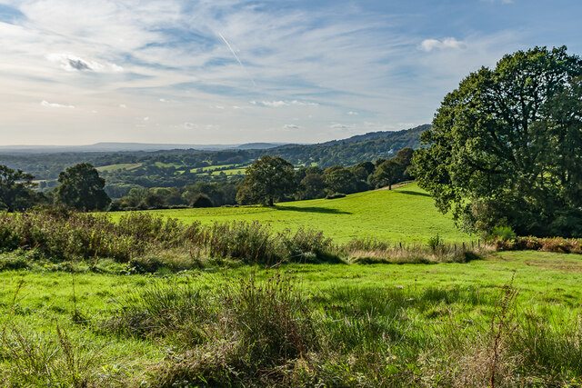
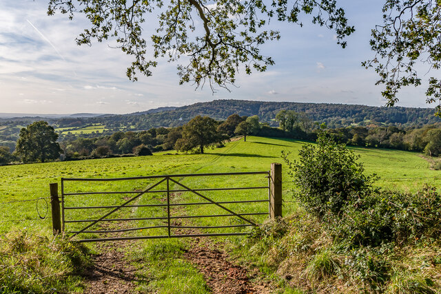
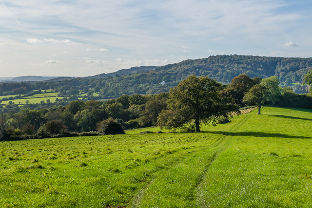
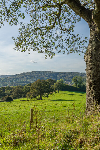
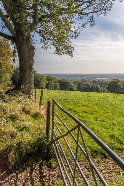
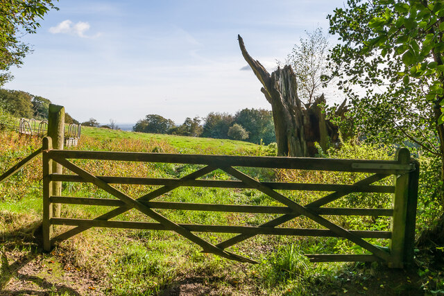
Orchard Copse is a picturesque woodland area located in Surrey, England. Situated in the southern region of the county, it covers an area of approximately 50 acres and is known for its diverse range of trees and natural beauty. The copse is predominantly made up of deciduous trees such as oak, beech, and birch, creating a stunning display of colors during the autumn months.

The woodland is home to an abundance of wildlife, including various bird species, small mammals, and insects. This makes it a popular destination for nature enthusiasts and birdwatchers, who can often be seen exploring the copse with binoculars and cameras in hand. The peaceful and tranquil atmosphere of Orchard Copse also makes it a great place for those seeking a quiet retreat away from the hustle and bustle of everyday life.

The copse is crisscrossed with footpaths and trails, which allow visitors to explore its natural wonders at their own pace. It is not uncommon to come across hidden clearings and small streams while wandering through the trees, adding to the sense of discovery and adventure.

Orchard Copse is easily accessible by both car and public transport, with nearby parking facilities and bus stops. There are also picnic areas and benches scattered throughout the woodland, providing the perfect spot to take a break and soak in the surrounding beauty.

Overall, Orchard Copse in Surrey is a delightful woodlands retreat, offering a peaceful escape into nature for those who wish to immerse themselves in the beauty of the natural world.

If you have any feedback on the listing, please let us know in the comments section below.

Orchard Copse Images

Images are sourced within 2km of 51.165885/-0.38052255 or Grid Reference TQ1341. Thanks to Geograph Open Source API. All images are credited.

Leith Hill - Rhododendron A common shrub on Leith Hill, part of the Greensand Ridge.
Leith Hill - Rhododendron
A common shrub on Leith Hill, part of the Greensand Ridge.
West from near Tanhurst Looking west from near Tanhurst, on the western slopes of Leith Hill.  In the far distance is Black Down.
West from near Tanhurst
Looking west from near Tanhurst, on the western slopes of Leith Hill. In the far distance is Black Down.
West from near Tanhurst Looking west from near Tanhurst, on the western slopes of Leith Hill.  In the distance is Holmbury Hill.
West from near Tanhurst
Looking west from near Tanhurst, on the western slopes of Leith Hill. In the distance is Holmbury Hill.
West from near Tanhurst Looking west from near Tanhurst, on the western slopes of Leith Hill.  In the distance is Holmbury Hill.
West from near Tanhurst
Looking west from near Tanhurst, on the western slopes of Leith Hill. In the distance is Holmbury Hill.
West from near Tanhurst Looking west from near Tanhurst, on the western slopes of Leith Hill.  In the distance is Holmbury Hill.
West from near Tanhurst
Looking west from near Tanhurst, on the western slopes of Leith Hill. In the distance is Holmbury Hill.
South from near Tanhurst Looking south from near Tanhurst, on the western slopes of Leith Hill.  In the far distance are the South Downs.
South from near Tanhurst
Looking south from near Tanhurst, on the western slopes of Leith Hill. In the far distance are the South Downs.
South from above Tanhurst Looking south from above Tanhurst, on the western slopes of Leith Hill.
South from above Tanhurst
Looking south from above Tanhurst, on the western slopes of Leith Hill.
Drinking trough Drinking trough and fountain near the summit of Leith Hill.  Originally installed in Roehampton Vale, Wandsworth, by the Metropolitan Drinking Fountain and Cattle Trough Association, it was moved here in July 2018 with the support of the charity (now known as The Drinking Fountain Association).
Drinking trough
Drinking trough and fountain near the summit of Leith Hill. Originally installed in Roehampton Vale, Wandsworth, by the Metropolitan Drinking Fountain and Cattle Trough Association, it was moved here in July 2018 with the support of the charity (now known as The Drinking Fountain Association).
Leith Hill Tower Tower on the summit of Leith Hill, built in 1774-5 with the stair turret added in 1864.  Grade II listed - see <span class="nowrap"><a title="www.historicengland.org.uk/listing/the-list/list-entry/1028808" rel="nofollow ugc noopener" href="http://www.historicengland.org.uk/listing/the-list/list-entry/1028808">Link</a><img style="margin-left:2px;" alt="External link" title="External link - shift click to open in new window" src="https://s1.geograph.org.uk/img/external.png" width="10" height="10"/></span>.
Leith Hill Tower
Tower on the summit of Leith Hill, built in 1774-5 with the stair turret added in 1864. Grade II listed - see LinkExternal link.
Leith Hill summit The summit of Leith Hill, with the drinking trough installed in 2018 on the left (see <a href="https://www.geograph.org.uk/photo/6994981">TQ1343 : Drinking trough</a> and Leith Hill Tower in the background (see <a href="https://www.geograph.org.uk/photo/6994999">TQ1343 : Leith Hill Tower</a>).
Leith Hill summit
The summit of Leith Hill, with the drinking trough installed in 2018 on the left (see TQ1343 : Drinking trough and Leith Hill Tower in the background (see TQ1343 : Leith Hill Tower).
Track Track off Leith Hill Road.
Track
Track off Leith Hill Road.
High Ashes Farm Farm off Leith Hill Road.
High Ashes Farm
Farm off Leith Hill Road.
Driveway Driveway for The Coach House, Tanhurst.
Driveway
Driveway for The Coach House, Tanhurst.
The Coach House The Coach House is on the left of the photo and was formerly the coach house to Tanhurst, a late 18th Century mansion.  For some years, Tanhurst was the home of Sir Edward and Lady Jane Vaughan Williams, grandparents to Ralph Vaughan Williams.  The Coach House was converted into its present form in 1960.  The building on the right, a former barn, was converted to holiday accommodation in the late 2010s.
The Coach House
The Coach House is on the left of the photo and was formerly the coach house to Tanhurst, a late 18th Century mansion. For some years, Tanhurst was the home of Sir Edward and Lady Jane Vaughan Williams, grandparents to Ralph Vaughan Williams. The Coach House was converted into its present form in 1960. The building on the right, a former barn, was converted to holiday accommodation in the late 2010s.
The Coach House The Coach House is in the centre of the photo and was formerly the coach house to Tanhurst, a late 18th Century mansion.  For some years, Tanhurst was the home of Sir Edward and Lady Jane Vaughan Williams, grandparents to Ralph Vaughan Williams.  The Coach House was converted into its present form in 1960.  The building on the right, a former barn, was converted to holiday accommodation in the late 2010s.
The Coach House
The Coach House is in the centre of the photo and was formerly the coach house to Tanhurst, a late 18th Century mansion. For some years, Tanhurst was the home of Sir Edward and Lady Jane Vaughan Williams, grandparents to Ralph Vaughan Williams. The Coach House was converted into its present form in 1960. The building on the right, a former barn, was converted to holiday accommodation in the late 2010s.
Leith Hill Place This property is now administered by the National Trust and previously has been home to Wedgwood, Darwin and Vaughan Williams families.
Leith Hill Place
This property is now administered by the National Trust and previously has been home to Wedgwood, Darwin and Vaughan Williams families.
Leith Hill Place - Graffiti Colourful graffiti in the cellar created probably in the 1960s when this house was a school.
Leith Hill Place - Graffiti
Colourful graffiti in the cellar created probably in the 1960s when this house was a school.
Leith Hill Place - Mural Schoolboy artwork, probably 1960s, in the cellar in this former school.
Leith Hill Place - Mural
Schoolboy artwork, probably 1960s, in the cellar in this former school.
Show me another place!

Orchard Copse is located at Grid Ref: TQ1341 (Lat: 51.165885, Lng: -0.38052255)

Administrative County: Surrey

District: Mole Valley

Police Authority: Surrey

What 3 Words

///newsstand.spooked.supposes. Near Holmwood, Surrey

Related Wikis

Greensand Ridge

The Greensand Ridge, also known as the Wealden Greensand, is an extensive, prominent, often wooded, mixed greensand/sandstone escarpment in south-east...

Greensand Way

The Greensand Way is a long-distance path of 108 miles (174 km) in southeast England, from Haslemere in Surrey to Hamstreet in Kent. It follows the Greensand...

Leith Hill

Leith Hill in southern England is the highest summit of the Greensand Ridge, approximately 6.7 km (4 mi) southwest of Dorking, Surrey and 40.5 km (30 mi...

Leith Hill multiple aircraft accident

On 26 November 1944, four C-47 transport aircraft of the 442nd Operations Group departed from Advanced Landing Ground "A-4 in Pays de la Loire, northern...

Broome Hall

Broome Hall is a Grade II-listed country house with grounds including cottages and outhouses on the wooded, upper southern slopes of the Greensand Ridge...

Leith Hill SSSI

Leith Hill SSSI is a 337.9-hectare (835-acre) biological Site of Special Scientific Interest south-east of Dorking in Surrey. The SSSI consists of four...

Ockley

Ockley is a rural village in Surrey. It lies astride the A29, the modern road using the alignment of Stane Street (Chichester). The A29 diverges from the...

Joldwynds

Joldwynds is a modernist style house in Holmbury St Mary, Surrey, England, designed by architect Oliver Hill for Wilfred Greene, 1st Baron Greene. Completed...

Nearby Amenities

Located within 500m of 51.165885,-0.38052255
Leith Hill Place
Addr City: Dorking
Addr Postcode: RH5 6LY
Addr Street: Leith Hill Lane
Place: isolated_dwelling
Source: npe
Wikidata: Q17547625
Lat/Long: 51.1693914/-0.3797717
Barrier: kissing_gate
Lat/Long: 51.1696668/-0.3828575
Barrier: kissing_gate
Lat/Long: 51.1628112/-0.3813852
Barrier: kissing_gate
Lat/Long: 51.1653485/-0.3857779
Barrier: stile
Lat/Long: 51.1642987/-0.3834684
Barrier: kissing_gate
Lat/Long: 51.1621787/-0.3805605
Barrier: kissing_gate
Lat/Long: 51.1641499/-0.3763655
Barrier: kissing_gate
Lat/Long: 51.1649089/-0.3850302
Cafe
Description: Inside house, runs on donations
Wheelchair: yes
Lat/Long: 51.169379/-0.3792847
Leith Hill Place Farm
Place: farm
Lat/Long: 51.1700348/-0.3789745
Power: pole
Lat/Long: 51.1673713/-0.3740451
Power: pole
Lat/Long: 51.1673923/-0.3754845
Power: pole
Lat/Long: 51.1674203/-0.3769486
The data included in this document is from www.openstreetmap.org. The data is made available under ODbL.

Have you been to Orchard Copse?

Leave your review of Orchard Copse below (or comments, questions and feedback).