Nanscot Wood

Wood, Forest in Hertfordshire Three Rivers

England

Nanscot Wood

Direction Sign - Signpost by the A404 Uxbridge Road, Pinner Nipple finial - 2 arms; Middlesex CC iron by the A404, formerly the A410, in parish of Pinner (Harrow District), Uxbridge Road junction with Woodhall Drive.

Surveyed

Milestone Society National ID: MX_TQ1290
Direction Sign - Signpost by the A404 Uxbridge Road, Pinner Credit: C Woodward

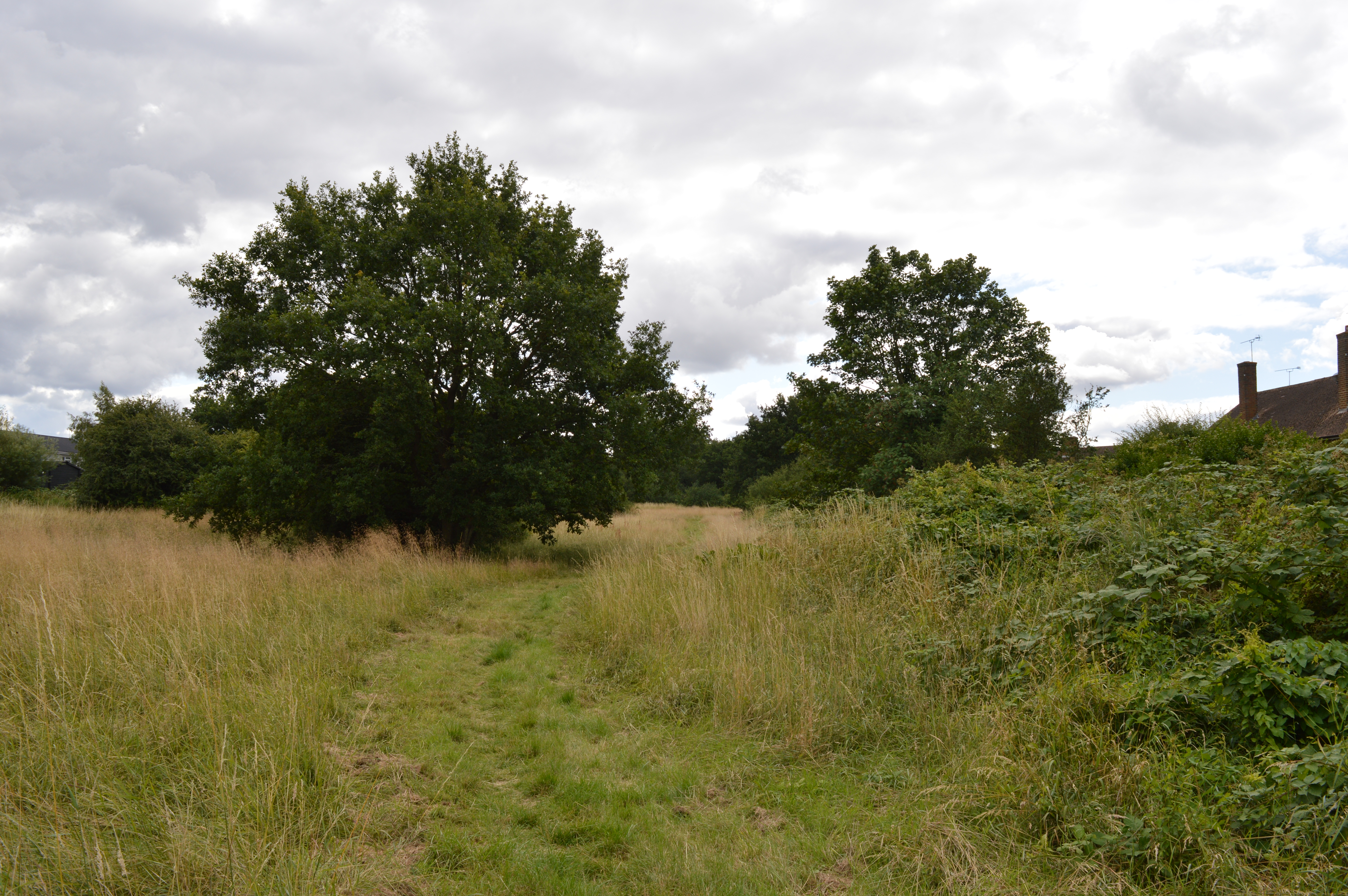
Nanscot Wood is a picturesque woodland located in Hertfordshire, England. Covering an area of approximately 100 hectares, it is a popular spot for nature enthusiasts and outdoor adventurers. The wood is part of a larger forested area, known as Nanscot Forest, which encompasses a diverse range of trees and wildlife.

The wood is predominantly made up of broadleaf species, such as oak, beech, and ash trees, creating a lush and vibrant canopy overhead. The forest floor is covered in a thick carpet of moss and ferns, adding to the enchanting atmosphere. Visitors can also find patches of bluebells during the spring, creating a stunning display of color.

Nanscot Wood is home to a variety of wildlife, including deer, badgers, and squirrels. Birdwatchers will be delighted by the numerous species that can be spotted here, such as woodpeckers, owls, and songbirds. The wood provides an important habitat for these creatures, as well as a peaceful sanctuary for those seeking solace in nature.

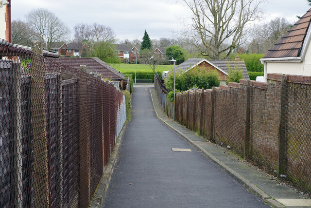
There are several walking trails that wind their way through Nanscot Wood, providing visitors with the opportunity to explore and discover the beauty of the surroundings. These trails are well-maintained and suitable for all ages and fitness levels. Along the way, there are informative signposts that provide insight into the forest's history and ecology.

Nanscot Wood is easily accessible, with a car park located nearby, as well as public transportation options. Whether you are an avid nature lover, a family looking for a fun day out, or simply seeking a tranquil escape from the hustle and bustle of everyday life, Nanscot Wood is a must-visit destination in Hertfordshire.

If you have any feedback on the listing, please let us know in the comments section below.

Nanscot Wood Images

Images are sourced within 2km of 51.615369/-0.39408379 or Grid Reference TQ1191. Thanks to Geograph Open Source API. All images are credited.

Direction Sign - Signpost by the A404 Uxbridge Road, Pinner Nipple finial - 2 arms; Middlesex CC iron by the A404, formerly the A410, in parish of Pinner (Harrow District), Uxbridge Road junction with Woodhall Drive.

Surveyed

Milestone Society National ID: MX_TQ1290
Direction Sign - Signpost by the A404 Uxbridge Road, Pinner
Nipple finial - 2 arms; Middlesex CC iron by the A404, formerly the A410, in parish of Pinner (Harrow District), Uxbridge Road junction with Woodhall Drive. Surveyed Milestone Society National ID: MX_TQ1290
The Parade, Carpenders Park The Parade is a typical suburban row of shops located at the junction of Delta Gain and Carpenders Avenue. The businesses include Carpenders Park post office and a florist's shop.
The Parade, Carpenders Park
The Parade is a typical suburban row of shops located at the junction of Delta Gain and Carpenders Avenue. The businesses include Carpenders Park post office and a florist's shop.
Carpenders Avenue, Carpenders Park Carpenders Park is very much an outer London suburb although it is situated outside the Greater London area. The development took place either side of the Second World War and the housing is typical of its time including a significant number of bungalows. The name is derived from a local manor house that was demolished in 1960 but has perhaps survived because it was given to the nearby railway station.
Carpenders Avenue, Carpenders Park
Carpenders Park is very much an outer London suburb although it is situated outside the Greater London area. The development took place either side of the Second World War and the housing is typical of its time including a significant number of bungalows. The name is derived from a local manor house that was demolished in 1960 but has perhaps survived because it was given to the nearby railway station.
Path to The Mead, Carpenders Park Designated a public footpath, and signed accordingly, this route cuts through between the houses on Carpenders Avenue and The Mead at the bottom.
Path to The Mead, Carpenders Park
Designated a public footpath, and signed accordingly, this route cuts through between the houses on Carpenders Avenue and The Mead at the bottom.
The Partridge, Carpenders Park Not, in all honesty, a particularly prepossessing looking pub externally, the Partridge offers cask ales, Sky Sports and pub games and is a short walk from Carpenders Park station.
The Partridge, Carpenders Park
Not, in all honesty, a particularly prepossessing looking pub externally, the Partridge offers cask ales, Sky Sports and pub games and is a short walk from Carpenders Park station.
Carpenders Park Station Carpenders Park is a stop on the London Overground route between Euston and Watford Junction. The pedestrian tunnel passes under the West Coast Main Line and gives access to the island platform on the 'DC lines'. It also connects Carpenders Park to the east of the railway and South Oxhey to the west - two outer suburbs with very different characters. The original station here (located to the north of the current one) was opened in 1914 to serve a nearby golf course in what was then a very rural area. The modern structure was opened in 1952. Note the bewildering number of safety signs visible in this view: 'No rollerblading, skating or cycling'; 'No smoking'; 'No alcohol'; 'CCTV cameras in operation'; 'No cycling'; 'Bicycle restrictions'; 'No trespassing' (three in all); 'Danger electricity'; and 'Danger overhead live wires'.
Carpenders Park Station
Carpenders Park is a stop on the London Overground route between Euston and Watford Junction. The pedestrian tunnel passes under the West Coast Main Line and gives access to the island platform on the 'DC lines'. It also connects Carpenders Park to the east of the railway and South Oxhey to the west - two outer suburbs with very different characters. The original station here (located to the north of the current one) was opened in 1914 to serve a nearby golf course in what was then a very rural area. The modern structure was opened in 1952. Note the bewildering number of safety signs visible in this view: 'No rollerblading, skating or cycling'; 'No smoking'; 'No alcohol'; 'CCTV cameras in operation'; 'No cycling'; 'Bicycle restrictions'; 'No trespassing' (three in all); 'Danger electricity'; and 'Danger overhead live wires'.
Pearkes House, South Oxhey Pearkes House is part of a redevelopment project called South Oxhey Central, close to Carpenders Park station, that includes residential apartments, work spaces and retail units. The developer is Countryside Properties and work began in 2016.
Pearkes House, South Oxhey
Pearkes House is part of a redevelopment project called South Oxhey Central, close to Carpenders Park station, that includes residential apartments, work spaces and retail units. The developer is Countryside Properties and work began in 2016.
South Oxhey Central This construction is part of the South Oxhey Central development. The new apartment block is replacing a parade of shop units, with flats above, that certainly had a tired look but was perhaps on a more appropriate scale for this outer suburban location. Be that as it may, the new housing is being heavily marketed by the developer, Countryside Properties, and a huge representation of how prospective residents' bathrooms might look is displayed on the hoardings outside.
South Oxhey Central
This construction is part of the South Oxhey Central development. The new apartment block is replacing a parade of shop units, with flats above, that certainly had a tired look but was perhaps on a more appropriate scale for this outer suburban location. Be that as it may, the new housing is being heavily marketed by the developer, Countryside Properties, and a huge representation of how prospective residents' bathrooms might look is displayed on the hoardings outside.
Forfar House, South Oxhey Forfar House is an apartment block which, together with two similar blocks, overlooks a green off Oxhey Drive. Part of Filton House can be seen in this picture. The estate at South Oxhey was developed by the then London County Council (LCC) in the early 1950s, one of a number built on the fringes of London to help relieve overcrowding in the inner city area. It was not actually within the LCC's area and is still within the modern boundaries of Hertfordshire today. In 1980 the Greater London Council (which had absorbed the LCC) passed the ownership and management of the estate to Three Rivers District Council. Today, a large proportion of the housing stock is privately owned and the remaining social housing has been transferred to a housing association.
Forfar House, South Oxhey
Forfar House is an apartment block which, together with two similar blocks, overlooks a green off Oxhey Drive. Part of Filton House can be seen in this picture. The estate at South Oxhey was developed by the then London County Council (LCC) in the early 1950s, one of a number built on the fringes of London to help relieve overcrowding in the inner city area. It was not actually within the LCC's area and is still within the modern boundaries of Hertfordshire today. In 1980 the Greater London Council (which had absorbed the LCC) passed the ownership and management of the estate to Three Rivers District Council. Today, a large proportion of the housing stock is privately owned and the remaining social housing has been transferred to a housing association.
Oxhey Drive, South Oxhey The large London County Council development at South Oxhey was built in the early 1950s to relieve overcrowding in the inner city, where much of the housing stock had been lost due to wartime bombing. The houses here are typical of local authority estates of the era including this terrace on Oxhey Drive. The houses were generally well-built and relatively sizeable with decent gardens - in some ways better than their equivalents built for the private market. They must have seemed like paradise for many of their first residents. Today a majority of the houses at South Oxhey are privately owned.
Oxhey Drive, South Oxhey
The large London County Council development at South Oxhey was built in the early 1950s to relieve overcrowding in the inner city, where much of the housing stock had been lost due to wartime bombing. The houses here are typical of local authority estates of the era including this terrace on Oxhey Drive. The houses were generally well-built and relatively sizeable with decent gardens - in some ways better than their equivalents built for the private market. They must have seemed like paradise for many of their first residents. Today a majority of the houses at South Oxhey are privately owned.
Moortown Road, South Oxhey Moortown Road leads south off Maylands Road, part of the London County Council built estate at South Oxhey dating from the early 1950s.
Moortown Road, South Oxhey
Moortown Road leads south off Maylands Road, part of the London County Council built estate at South Oxhey dating from the early 1950s.
Oxhey Woods This area of the woods, to the north of Oxhey Drive, is referred to as the northern woodland, distinguishing it from the central woodland on the other side of the road.
Oxhey Woods
This area of the woods, to the north of Oxhey Drive, is referred to as the northern woodland, distinguishing it from the central woodland on the other side of the road.
Oxhey Woods There are a number of designated paths through Oxhey Woods including the 'Long Walk' seen here in the northern woodland.
Oxhey Woods
There are a number of designated paths through Oxhey Woods including the 'Long Walk' seen here in the northern woodland.
Oxhey Woods Showing part of the central woodland with a path leading to Oxhey Drive.
Oxhey Woods
Showing part of the central woodland with a path leading to Oxhey Drive.
Oxhey Woods Showing a clearing in the central woodland area.
Oxhey Woods
Showing a clearing in the central woodland area.
Oxhey Woods Looking into the central woodland along the path leading off Oxhey Drive.
Oxhey Woods
Looking into the central woodland along the path leading off Oxhey Drive.
Watford Road, Northwood The A4125 drops down towards the centre of Northwood in an area characterised by large gated properties set well back from the road.
Watford Road, Northwood
The A4125 drops down towards the centre of Northwood in an area characterised by large gated properties set well back from the road.
Hatch End Station The down (away from London) platform at Hatch End has a fine display of floral tubs. Even the poster advertises the Royal Horticultural Society.
Hatch End Station
The down (away from London) platform at Hatch End has a fine display of floral tubs. Even the poster advertises the Royal Horticultural Society.
Show me another place!

Nanscot Wood is located at Grid Ref: TQ1191 (Lat: 51.615369, Lng: -0.39408379)

Administrative County: Hertfordshire

District: Three Rivers

Police Authority: Hertfordshire

What 3 Words

///dreams.friend.tame. Near Pinner, London

Nearby Locations

Nanscot Wood Pinner Wood

Related Wikis

Prestwick Road Meadows

Prestwick Road Meadows is a 2.8 hectare Local Nature Reserve in South Oxhey in Hertfordshire. It is owned and managed by Three Rivers District Council...

Oxhey Woods

Oxhey Woods is a 98 hectare Local Nature Reserve in South Oxhey in Hertfordshire, England. It is owned and managed by Three Rivers District Council. It...

South Oxhey

South Oxhey is a village in the Watford Rural parish of the Three Rivers district of Hertfordshire, England. It is located in the south western corner...

Oxhey Jets F.C.

Oxhey Jets Football Club is an English semi-professional football club based in South Oxhey - a suburb of Watford, Hertfordshire. Founded by John R Elliott...

Nearby Amenities

Located within 500m of 51.615369,-0.39408379
Ref GB Tflcid: RWG269083
Traffic Calming: yes
Lat/Long: 51.6126914/-0.3889817
Crossing
Crossing: marked
Crossing Island: yes
Lat/Long: 51.6176173/-0.3975233
Crossing
Crossing: traffic_signals
Lat/Long: 51.6168708/-0.3943311
Speed Trap
Created By: Potlatch 0.10c
Lat/Long: 51.6171687/-0.3928492
Post Box
Created By: Potlatch 0.10e
Lat/Long: 51.6168905/-0.3938953
Barrier: kissing_gate
Lat/Long: 51.6153477/-0.3906852
Bus Stop
Heysham Drive
Bus: yes
Naptan AtcoCode: 210021803100
Naptan Bearing: W
Naptan CommonName: Heysham Drive
Naptan Indicator: adj
Naptan Landmark: Unknown
Naptan NaptanCode: hrtajdgw
Naptan PlusbusZoneRef: WATFDJ
Naptan ShortCommonName: NA
Naptan Street: Prestwick Road
Naptan Verified: no
Public Transport: platform
Shelter: yes
Source: naptan_import
Lat/Long: 51.6171163/-0.3925997
Bus Stop
Ashridge Drive
Naptan AtcoCode: 210021803120
Naptan Bearing: NW
Naptan CommonName: Ashridge Drive
Naptan Indicator: opp
Naptan Landmark: Unknown
Naptan NaptanCode: hrtajdja
Naptan PlusbusZoneRef: WATFDJ
Naptan ShortCommonName: NA
Naptan Street: Prestwick Road
Naptan Verified: no
Public Transport: platform
Shelter: no
Source: naptan_import
Lat/Long: 51.6186635/-0.3985754
Bus Stop
Ashridge Drive
Bus: yes
Naptan AtcoCode: 210021803720
Naptan Bearing: SE
Naptan CommonName: Ashridge Drive
Naptan Indicator: nr
Naptan Landmark: Unknown
Naptan NaptanCode: hrtajamd
Naptan PlusbusZoneRef: WATFDJ
Naptan ShortCommonName: NA
Naptan Street: Prestwick Road
Naptan Verified: no
Public Transport: platform
Source: naptan_import
Lat/Long: 51.6186173/-0.398288
Bus Stop
Heysham Drive
Bus: yes
Naptan AtcoCode: 210021803740
Naptan Bearing: E
Naptan CommonName: Heysham Drive
Naptan Indicator: opp
Naptan Landmark: Unknown
Naptan NaptanCode: hrtajamj
Naptan PlusbusZoneRef: WATFDJ
Naptan ShortCommonName: NA
Naptan Street: Prestwick Road
Naptan Verified: no
Public Transport: platform
Shelter: yes
Source: naptan_import
Lat/Long: 51.6173448/-0.3921766
Barrier: kissing_gate
Lat/Long: 51.6155312/-0.3881599
Golf: pin
Lat/Long: 51.614828/-0.3930488
Golf: pin
Lat/Long: 51.6127794/-0.3909621
Golf: pin
Lat/Long: 51.6116834/-0.3914234
Golf: pin
Lat/Long: 51.6140685/-0.3929362
Golf: pin
Lat/Long: 51.6124863/-0.3928181
Golf: pin
Lat/Long: 51.611387/-0.3951463
Golf: pin
Lat/Long: 51.6111837/-0.396364
Golf: pin
Lat/Long: 51.6120632/-0.3934941
Golf: pin
Lat/Long: 51.61181/-0.3984401
Direction: 160
Generator Method: photovoltaic
Generator Output Electricity: yes
Generator Solar Modules: 16
Generator Source: solar
Generator Type: solar_photovoltaic_panel
Location: roof
Power: generator
Lat/Long: 51.6155205/-0.3902648
Direction: 130
Generator Method: photovoltaic
Generator Output Electricity: yes
Generator Solar Modules: 11
Generator Source: solar
Generator Type: solar_photovoltaic_panel
Location: roof
Power: generator
Lat/Long: 51.6160459/-0.3913975
Direction: 205
Generator Method: photovoltaic
Generator Output Electricity: yes
Generator Solar Modules: 12
Generator Source: solar
Generator Type: solar_photovoltaic_panel
Location: roof
Power: generator
Lat/Long: 51.6196894/-0.3934202
Direction: 25
Generator Method: photovoltaic
Generator Output Electricity: yes
Generator Solar Modules: 4
Generator Source: solar
Generator Type: solar_photovoltaic_panel
Location: roof
Power: generator
Lat/Long: 51.619735/-0.393385
Direction: 205
Generator Method: photovoltaic
Generator Output Electricity: yes
Generator Solar Modules: 12
Generator Source: solar
Generator Type: solar_photovoltaic_panel
Location: roof
Power: generator
Lat/Long: 51.6197961/-0.3937811
Traffic Signals
Traffic Signals Direction: backward
Lat/Long: 51.61686/-0.3943943
Traffic Signals
Traffic Signals Direction: forward
Lat/Long: 51.6168798/-0.394268
The data included in this document is from www.openstreetmap.org. The data is made available under ODbL.

Have you been to Nanscot Wood?

Leave your review of Nanscot Wood below (or comments, questions and feedback).