Land End Copse

Wood, Forest in Surrey Waverley

England

Land End Copse

The entrance to Baynard's Park Estate
The entrance to Baynard's Park Estate Credit: David Howard

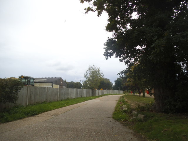
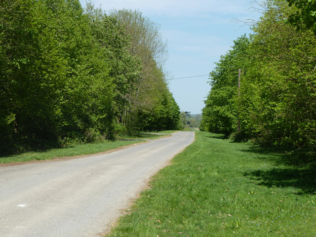
Land End Copse is a picturesque wood located in Surrey, England. Spanning over a vast area, it is a prominent feature of the local landscape and a popular destination for nature enthusiasts. This enchanting forest is known for its rich biodiversity and captivating beauty.

The copse is primarily composed of a mixture of deciduous and coniferous trees, creating a diverse and vibrant ecosystem. Towering oak, beech, and chestnut trees dominate the landscape, providing a dense canopy that filters the sunlight and creates a magical atmosphere within the wood. The forest floor is adorned with a variety of wildflowers, ferns, and mosses, adding splashes of color and texture to the scene.

Tranquil streams meander through the copse, nourishing the vegetation and attracting an array of wildlife. Birdsong fills the air as various species, such as woodpeckers, robins, and thrushes, nest and forage amongst the trees. Small mammals like squirrels and rabbits can also be spotted darting through the undergrowth, while occasional deer sightings add to the sense of wonder and natural beauty.

Visitors to Land End Copse can explore a network of well-maintained trails, allowing them to fully immerse themselves in the woodland experience. Whether hiking, cycling, or simply enjoying a leisurely stroll, there is something for everyone. The copse is also equipped with picnic areas, providing an opportunity for visitors to relax and enjoy a meal amidst the serene surroundings.

Overall, Land End Copse is a captivating woodland retreat that offers a peaceful escape from the hustle and bustle of everyday life. Its natural splendor and diverse wildlife make it a must-visit destination for nature lovers and those seeking a tranquil outdoor experience.

If you have any feedback on the listing, please let us know in the comments section below.

Land End Copse Images

Images are sourced within 2km of 51.119048/-0.42844124 or Grid Reference TQ1036. Thanks to Geograph Open Source API. All images are credited.

The entrance to Baynard's Park Estate
The entrance to Pollingfold Farm
The Wheatsheaf pub, Ellen's Green
Bridleway, Baynard's Park Passing through Eastgate Wood.
Bridleway, Baynard's Park
Passing through Eastgate Wood.
Bridge on drive from Home Farm, Baynard's Park Cobbler's Brook is crossed.
Bridge on drive from Home Farm, Baynard's Park
Cobbler's Brook is crossed.
New Cottages Home Farm, Baynard's Park.
New Cottages
Home Farm, Baynard's Park.
Footbridge over stream The stream is the outfall from an ornamental lake in Baynard's Park.
Footbridge over stream
The stream is the outfall from an ornamental lake in Baynard's Park.
Clock tower, Baynard's Park Just about the only surviving part of the mansion here, which burnt down in 1979. Grade II listed, 19th century. The outbuildings, just visible here, also survived.
Clock tower, Baynard's Park
Just about the only surviving part of the mansion here, which burnt down in 1979. Grade II listed, 19th century. The outbuildings, just visible here, also survived.
Trees, Baynard's Park Home Farm is beyond.
Trees, Baynard's Park
Home Farm is beyond.
Woodland path, Baynard's Park Public footpath towards Kennels Cottages and onwards to Rudgwick.
Woodland path, Baynard's Park
Public footpath towards Kennels Cottages and onwards to Rudgwick.
Bluebells by woodland path A public footpath to Rudgwick.
Bluebells by woodland path
A public footpath to Rudgwick.
Woodland shed A Nissen hut in Baynard's Park.
Woodland shed
A Nissen hut in Baynard's Park.
Linacre Drive, Baynard's Park The principal drive leading to the site of the mansion, which burnt down in 1979. It is private.
Linacre Drive, Baynard's Park
The principal drive leading to the site of the mansion, which burnt down in 1979. It is private.
Woodland path, Grub Copse A public route to Rudgwick through Baynard's Park.
Woodland path, Grub Copse
A public route to Rudgwick through Baynard's Park.
Bluebells, Grub Copse In Baynard's Park.
Bluebells, Grub Copse
In Baynard's Park.
Field edge footpath Towards Tillhouse Farm and onwards to the B2128.
Field edge footpath
Towards Tillhouse Farm and onwards to the B2128.
Public footpath nearing Tillhouse Farm Here the path runs along the edge of an orchard which these days is effectively an extension of the back garden of the residential farm.
Public footpath nearing Tillhouse Farm
Here the path runs along the edge of an orchard which these days is effectively an extension of the back garden of the residential farm.
Show me another place!

Land End Copse is located at Grid Ref: TQ1036 (Lat: 51.119048, Lng: -0.42844124)

Administrative County: Surrey

District: Waverley

Police Authority: Surrey

What 3 Words

///enable.hazy.pencils. Near Rudgwick, West Sussex

Related Wikis

Smokejack Clay Pit

Smokejack Clay Pit is a 56-hectare (140-acre) geological Site of Special Scientific Interest east of Cranleigh in Surrey. It is a Geological Conservation...

High Weald AONB

The High Weald Area of Outstanding Natural Beauty is in south-east England. Covering an area of 1,450 square kilometres (560 sq mi), it takes up parts...

Baynards Park

Baynards Park is a 2,000 acres (810 ha) estate and site of a demolished country house with extant outbuildings, privately owned, in the south of the parishes...

Longhurst Lodge

Longhurst Lodge is a Grade II listed building in Cranleigh, Surrey, England. It is located on the former Baynards Park estate, about a quarter of a mile...

Holy Trinity Church, Rudgwick

Holy Trinity Church is the Anglican parish church of Rudgwick, a village in the Horsham district of West Sussex, England. The oldest part of the church...

Baynards railway station

Baynards was a railway station on the Cranleigh Line, between Guildford, Surrey, and Horsham, West Sussex, England. The station opened with the line on...

Wallis Wood

Wallis Wood is a 14-hectare (35-acre) nature reserve south-east of Ewhurst in Surrey. It is managed by the Surrey Wildlife Trust.A stream runs through...

Stane Street (Chichester)

Stane Street is the modern name of the 91 km-long (57 mi) Roman road in southern England that linked Londinium (London) to Noviomagus Reginorum (Chichester...

Nearby Amenities

Located within 500m of 51.119048,-0.42844124
Post Box
Operator: Royal Mail
Post Box Type: lamp
Ref: RH12 194
Royal Cypher: EIIR
Royal Cypher Wikidata: Q33102113
Source: photo
Lat/Long: 51.1182019/-0.4316954
Barrier: stile
Lat/Long: 51.118306/-0.4266832
Barrier: stile
Lat/Long: 51.1224893/-0.4272678
Bus Stop
Hardacre Kennels
Naptan AtcoCode: 40004411030A
Naptan Bearing: S
Naptan CommonName: Hardacre Kennels
Naptan Indicator: Just after
Naptan Landmark: Hardacre Kennels
Naptan NaptanCode: surdtgmj
Naptan Street: B2128
Naptan Verified: no
Public Transport: platform
Source: naptan_import
Lat/Long: 51.1181458/-0.4317232
Bus Stop
Hardacre Kennels
Naptan AtcoCode: 40004411030B
Naptan Bearing: N
Naptan BusStopType: CUS
Naptan CommonName: Hardacre Kennels
Naptan Indicator: Just Before
Naptan Landmark: Hardacre Kennels
Naptan NaptanCode: surgpdgp
Naptan Street: B2128
Naptan Verified: no
Public Transport: platform
Source: naptan_import
Lat/Long: 51.118056/-0.4319061
Barrier: stile
Lat/Long: 51.1203442/-0.4271127
Barrier: stile
Lat/Long: 51.1204092/-0.4271149
Barrier: stile
Lat/Long: 51.1197896/-0.4270755
Pollingfold Farm
Place: farm
Lat/Long: 51.1156915/-0.4300843
Somersbury Lodge
Place: isolated_dwelling
Lat/Long: 51.1231513/-0.4309739
Hill House
Place: isolated_dwelling
Lat/Long: 51.1211611/-0.4259528
Power: pole
Lat/Long: 51.1152002/-0.4303275
Hill House Farm
Place: farm
Lat/Long: 51.1191204/-0.4262383
The data included in this document is from www.openstreetmap.org. The data is made available under ODbL.

Have you been to Land End Copse?

Leave your review of Land End Copse below (or comments, questions and feedback).