Blue Bell Spinney
Wood, Forest in Northamptonshire
England
Blue Bell Spinney

Blue Bell Spinney is a picturesque woodland located in Northamptonshire, England. Covering an area of approximately 10 acres, it is a haven for nature enthusiasts and those seeking tranquility amidst the hustle and bustle of modern life.
The spinney is characterized by its dense and diverse vegetation, consisting primarily of native tree species such as oak, ash, and birch. These majestic trees provide a shady canopy that shelters a rich understory of wildflowers, ferns, and mosses. The woodland floor is carpeted with bluebells during spring, giving the spinney its name and creating a breathtaking sight for visitors.
A network of well-maintained footpaths weaves through the spinney, allowing visitors to explore its beauty at their own pace. The paths are lined with wooden benches, offering opportunities for visitors to sit and immerse themselves in the peaceful ambiance while listening to the melodious songs of the resident birds.
Blue Bell Spinney is also home to a diverse range of wildlife. Birdwatchers can spot various species, including woodpeckers, thrushes, and owls, while keen-eyed visitors may catch glimpses of elusive mammals like foxes, badgers, and deer.
The spinney is a popular destination for nature walks, picnics, and photography. Its accessibility and proximity to nearby villages make it a favorite spot for local residents and visitors alike. Managed by a local conservation group, Blue Bell Spinney is a testament to the importance of preserving and appreciating the natural beauty of Northamptonshire.
If you have any feedback on the listing, please let us know in the comments section below.
Blue Bell Spinney Images
Images are sourced within 2km of 52.519454/-0.39305159 or Grid Reference TL0992. Thanks to Geograph Open Source API. All images are credited.


Blue Bell Spinney is located at Grid Ref: TL0992 (Lat: 52.519454, Lng: -0.39305159)
Unitary Authority: North Northamptonshire
Police Authority: Northamptonshire
What 3 Words
///digs.extension.crossings. Near Oundle, Northamptonshire
Nearby Locations
Related Wikis
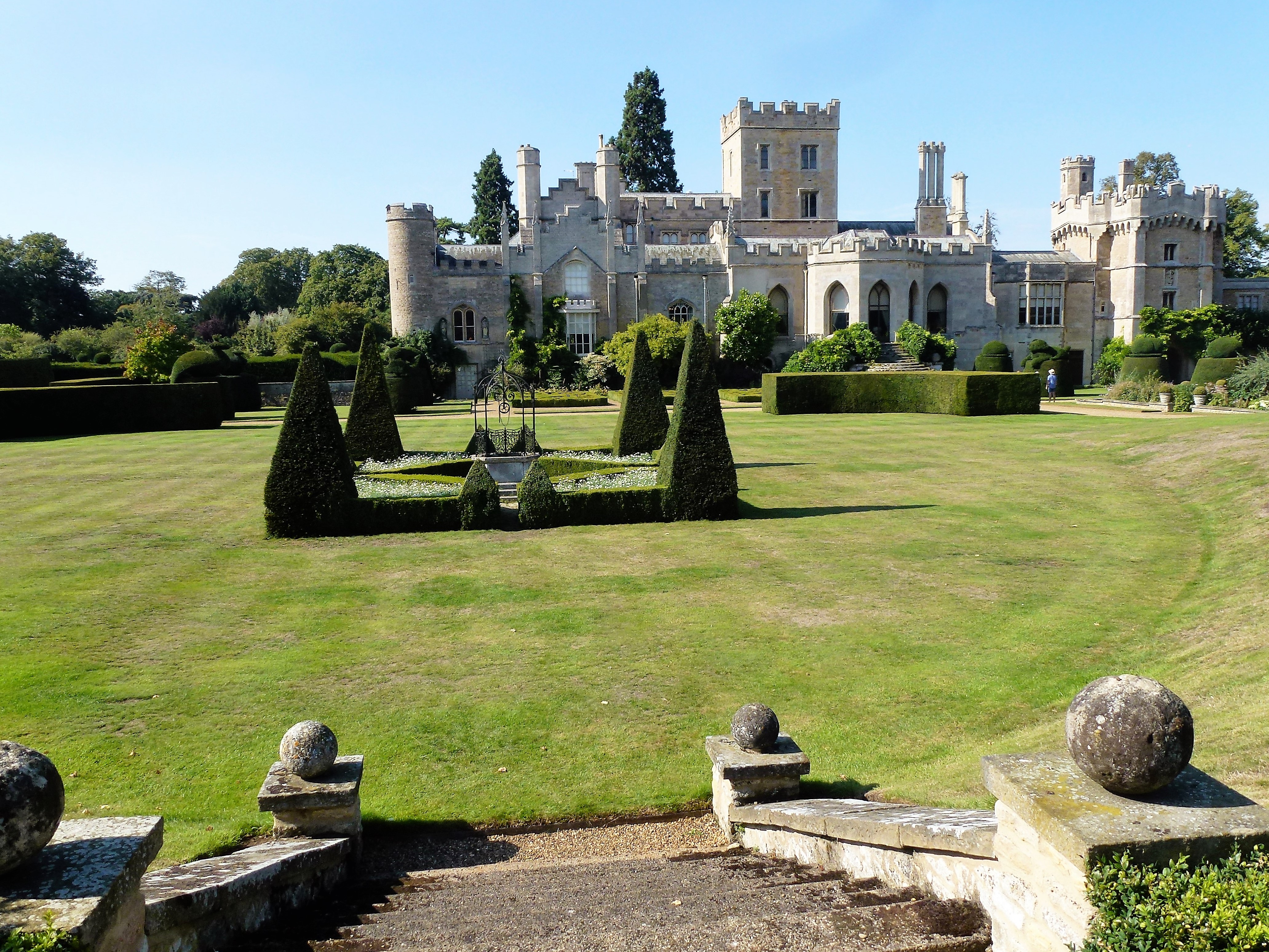
Elton Hall
Elton Hall is a baronial hall in Elton, Cambridgeshire. It has been the ancestral home of the Proby family (sometime known as the Earls of Carysfort)...

Elton, Cambridgeshire
Elton is a village and civil parish in Cambridgeshire, England. Elton lies approximately 7 miles (11 km) south-west of Peterborough. Elton is situated...
Warmington, Northamptonshire
Warmington is a village and civil parish in North Northamptonshire, England with a population of 874 (as of the 2001 census), increasing to 939 at the...
Elton railway station
Elton railway station is a former railway station in Elton, Cambridgeshire on former Northampton and Peterborough Railway which connected Peterborough...

Fotheringhay Castle
Fotheringhay Castle, also known as Fotheringay Castle, was a High Middle Age Norman Motte-and-bailey castle in the village of Fotheringhay 3+1⁄2 miles...
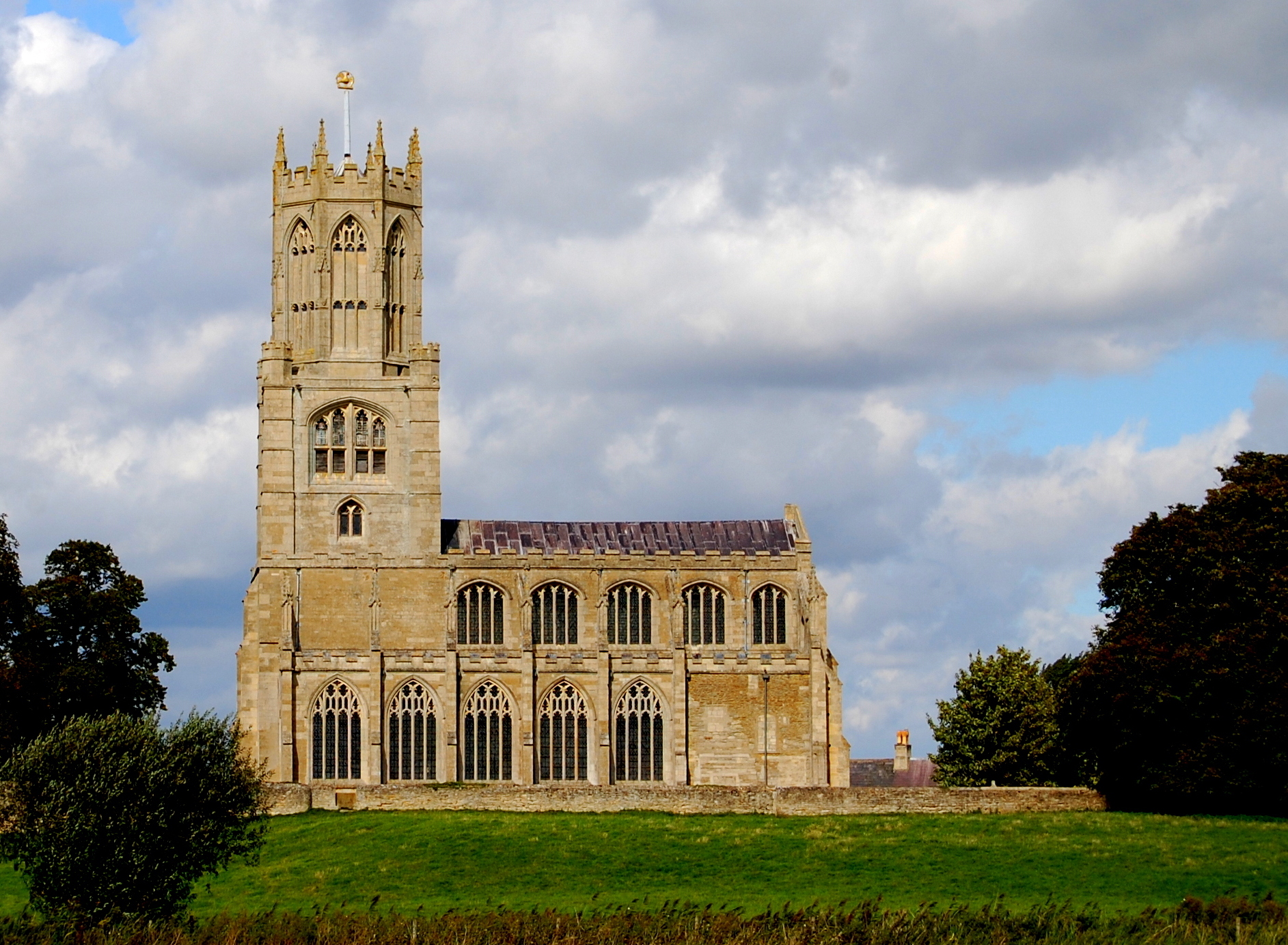
Church of St Mary and All Saints, Fotheringhay
The Church of St Mary and All Saints, Fotheringhay is a parish church in the Church of England in Fotheringhay, Northamptonshire. It is noted for containing...
RAF Sibson
Royal Air Force Sibson or more simply RAF Sibson is a former Royal Air Force satellite station located in Sibson, Cambridgeshire, England, west of Peterborough...

Peterborough transmitting station
The Peterborough transmitting station is a broadcasting and telecommunications facility at Morborne Hill, near Peterborough, England (grid reference TL127913...
Nearby Amenities
Located within 500m of 52.519454,-0.39305159Have you been to Blue Bell Spinney?
Leave your review of Blue Bell Spinney below (or comments, questions and feedback).