Lower Canfold Wood

Wood, Forest in Surrey Waverley

England

Lower Canfold Wood

Footpath 267, Cranleigh From Cranleigh Common to Ewhurst Road, crossing other roads on the way.
Footpath 267, Cranleigh Credit: Robin Webster

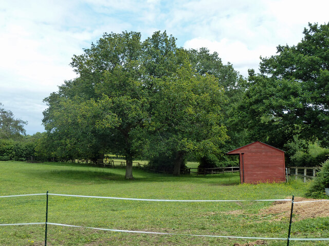
Lower Canfold Wood is a picturesque woodland located in Surrey, England. It covers an area of approximately 100 acres and is situated in the heart of the Surrey Hills Area of Outstanding Natural Beauty. The wood is renowned for its diverse flora and fauna, making it a popular destination for nature lovers and wildlife enthusiasts.

The woodland is predominantly composed of mixed deciduous trees, including oak, beech, and ash, which create a stunning canopy overhead. The forest floor is adorned with a variety of wildflowers, such as bluebells and primroses, providing a vibrant burst of color during the spring months.

Lower Canfold Wood is crisscrossed by numerous footpaths and trails, allowing visitors to explore its beauty at their own pace. These pathways lead to hidden gems within the wood, including a tranquil pond and a small stream that meanders through the trees. These water features provide a habitat for various aquatic species, including frogs, newts, and dragonflies.

The wood is also home to a rich array of wildlife. Birdwatchers can spot a range of species, including woodpeckers, owls, and jays. Squirrels can be seen scampering through the branches, while deer occasionally make an appearance, adding to the woodland's charm.

Lower Canfold Wood offers a peaceful and serene environment for visitors seeking a break from the hustle and bustle of daily life. Its natural beauty and diverse ecosystem make it a must-visit destination for anyone seeking a connection with nature in the heart of Surrey.

If you have any feedback on the listing, please let us know in the comments section below.

Lower Canfold Wood Images

Images are sourced within 2km of 51.141973/-0.45428124 or Grid Reference TQ0839. Thanks to Geograph Open Source API. All images are credited.

Footpath 267, Cranleigh From Cranleigh Common to Ewhurst Road, crossing other roads on the way.
Footpath 267, Cranleigh
From Cranleigh Common to Ewhurst Road, crossing other roads on the way.
Corner on The Ridgeway, Cranleigh Footpath 368 Cranleigh, having run along The Ridgeway up to this point, continues straight on as a narrow path to the left of the gate.
Corner on The Ridgeway, Cranleigh
Footpath 368 Cranleigh, having run along The Ridgeway up to this point, continues straight on as a narrow path to the left of the gate.
Wanborough Lane, Cranleigh Effectively bridleway 373, although the mapped route for this northern part is off to the right and does not seem to exist on the ground.
Wanborough Lane, Cranleigh
Effectively bridleway 373, although the mapped route for this northern part is off to the right and does not seem to exist on the ground.
Wanborough Lane, Cranleigh Bridleway 373, Cranleigh.
Wanborough Lane, Cranleigh
Bridleway 373, Cranleigh.
In Book Hurst Cranleigh footpath 368 threads its way through the woods.
In Book Hurst
Cranleigh footpath 368 threads its way through the woods.
Old gate by track, Book Hurst The private sign refers to the lands of Swallow's Tiles, formerly Bookhurst Pottery.  This had closed down in 2008.
Old gate by track, Book Hurst
The private sign refers to the lands of Swallow's Tiles, formerly Bookhurst Pottery. This had closed down in 2008.
Clearing in Book Hurst Possibly a result of the activities of Swallow's Tiles, this closed down in 2008.
Clearing in Book Hurst
Possibly a result of the activities of Swallow's Tiles, this closed down in 2008.
A peep at Swallow's Tiles site and houses beyond, 2011 Swallow's Tiles closed down in 2008. The derelict site was later cleared and redeveloped for housing. The visible houses are earlier. They are along Bookhurst Road.
A peep at Swallow's Tiles site and houses beyond, 2011
Swallow's Tiles closed down in 2008. The derelict site was later cleared and redeveloped for housing. The visible houses are earlier. They are along Bookhurst Road.
Small bridge on footpath 368, Cranleigh Towards Slythehurst.
Small bridge on footpath 368, Cranleigh
Towards Slythehurst.
Roebuck by road to Bowles Farm Also a rabbit - can you see it?  The road is private, but Cranleigh public footpath 575 follows it.
Roebuck by road to Bowles Farm
Also a rabbit - can you see it? The road is private, but Cranleigh public footpath 575 follows it.
Footpath 368, Cranleigh Towards Slythehurst.
Footpath 368, Cranleigh
Towards Slythehurst.
Footpath 368, Cranleigh Towards Slythehurst.
Footpath 368, Cranleigh
Towards Slythehurst.
Footpath 368, Cranleigh Towards Slythehurst.
Footpath 368, Cranleigh
Towards Slythehurst.
Footpath 368, Cranleigh The path goes right here, towards Cranleigh town.
Footpath 368, Cranleigh
The path goes right here, towards Cranleigh town.
Felled area, Lower Canfold Wood
Horse and stables, Slythehurst
Horse in field, Slythehurst
Field for horses, Slythehurst
Show me another place!

Lower Canfold Wood is located at Grid Ref: TQ0839 (Lat: 51.141973, Lng: -0.45428124)

Administrative County: Surrey

District: Waverley

Police Authority: Surrey

What 3 Words

///eyelash.remember.daunted. Near Ewhurst, Surrey

Related Wikis

Sayer's Croft LNR

Sayer's Croft is a 10.9-hectare (27-acre) Local Nature Reserve west of Ewhurst in Surrey. It is owned by the Sayer's Croft Environmental Education Trust...

Sayers Croft

Sayers Croft is a large outdoor 'learning camp' located in the village of Ewhurst, Surrey. It is one of the few remaining 'Camp schools' built by the National...

Ewhurst, Surrey

Ewhurst is a rural village and civil parish in the borough of Waverley in Surrey, England. It is located 8.3 miles (13.4 km) south-east of Guildford,...

Longhurst Lodge

Longhurst Lodge is a Grade II listed building in Cranleigh, Surrey, England. It is located on the former Baynards Park estate, about a quarter of a mile...

Nearby Amenities

Located within 500m of 51.141973,-0.45428124
Source: Surrey Air Survey
Lat/Long: 51.1392694/-0.4583996
Slithehurst Farm
Landuse: farmland
Note Retag: CS #48756035
Source: npe
Lat/Long: 51.1429665/-0.4487358
Barrier: stile
Lat/Long: 51.1443864/-0.4494204
Lower Canfold Wood
Natural: wood
Lat/Long: 51.1431706/-0.4556193
Barrier: stile
Lat/Long: 51.1444283/-0.4512818
Source: Surrey Air Survey, GPS
Lat/Long: 51.1430163/-0.4545611
Barrier: stile
Lat/Long: 51.1441165/-0.4483404
Barrier: stile
Lat/Long: 51.1434501/-0.457768
Leisure: bird_hide
Lat/Long: 51.1412655/-0.4584843
Barrier: stile
Lat/Long: 51.1443341/-0.4492183
Barrier: stile
Lat/Long: 51.1416455/-0.4473875
The data included in this document is from www.openstreetmap.org. The data is made available under ODbL.

Have you been to Lower Canfold Wood?

Leave your review of Lower Canfold Wood below (or comments, questions and feedback).