Fernhill Wood

Wood, Forest in Bedfordshire

England

Fernhill Wood

Sharpenhoe Clappers The pathway through the woods at Sharpenhoe Clappers
Sharpenhoe Clappers Credit: Bob Walters

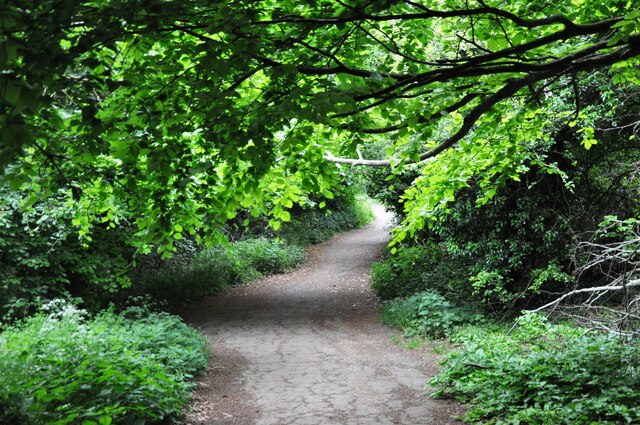
Fernhill Wood is a picturesque woodland located in the county of Bedfordshire, England. Covering an area of approximately 50 acres, this enchanting forest is a haven for nature lovers and outdoor enthusiasts alike.

The wood is predominantly made up of a diverse range of trees, including oak, beech, ash, and birch, creating a rich and varied ecosystem. The dense canopy provides a natural shelter for a wide array of wildlife, making it a popular spot for birdwatching and wildlife spotting. Visitors may be lucky enough to catch a glimpse of elusive creatures such as deer, foxes, and various species of birds.

A network of well-maintained footpaths and trails wind their way through the wood, making it easily accessible for walkers and hikers of all abilities. These paths offer a chance to explore the wood at a leisurely pace, and there are several benches and picnic spots along the way for visitors to rest and take in the serene surroundings.

Fernhill Wood is also home to a small pond, which adds to the overall charm of the area. The pond is teeming with life, with frogs, newts, and a variety of aquatic plants calling it their home. It is a popular spot for nature enthusiasts to observe and study aquatic ecosystems up close.

Overall, Fernhill Wood is a true gem in the Bedfordshire countryside, offering visitors a tranquil and immersive experience in the heart of nature. Whether it's a leisurely stroll, a wildlife adventure, or simply a peaceful escape from the hustle and bustle of everyday life, this woodland has something for everyone to enjoy.

If you have any feedback on the listing, please let us know in the comments section below.

Fernhill Wood Images

Images are sourced within 2km of 51.949052/-0.45695442 or Grid Reference TL0628. Thanks to Geograph Open Source API. All images are credited.

Sharpenhoe Clappers The pathway through the woods at Sharpenhoe Clappers
Sharpenhoe Clappers
The pathway through the woods at Sharpenhoe Clappers
Sundon Hills From Sundon Hills, looking North east.  Sundon Hills are believed to be the inspiration for 'The Delectable Mountains' in John Bunyan's 'The Pilgrim's Progress'.
Sundon Hills
From Sundon Hills, looking North east. Sundon Hills are believed to be the inspiration for 'The Delectable Mountains' in John Bunyan's 'The Pilgrim's Progress'.
Road junction between Upper Sundon & Streatley The road in the foreground goes to Upper Sundon, Streatley to the left and Lower Sundon to the right.
Road junction between Upper Sundon & Streatley
The road in the foreground goes to Upper Sundon, Streatley to the left and Lower Sundon to the right.
Reservoir and mast near Streatley, Bedfordshire
Sharpenhoe Clappers Sharpenhoe Clappers country park (National Trust) looking NNE with the Pulloxhill water tower visible near the horizon.
Sharpenhoe Clappers
Sharpenhoe Clappers country park (National Trust) looking NNE with the Pulloxhill water tower visible near the horizon.
Approach to Dyer's Hall farm and Sundon Hills. The centre of the grid is a few metres along the farm track to the right.  In the distance is the western end of the Sundon Hills.
Approach to Dyer's Hall farm and Sundon Hills.
The centre of the grid is a few metres along the farm track to the right. In the distance is the western end of the Sundon Hills.
Roundabout on the A6 Looking East with the village of Streatley behind.
The A6 crosses an unclassified road with Bedford to the left and Luton to the right.
Roundabout on the A6
Looking East with the village of Streatley behind. The A6 crosses an unclassified road with Bedford to the left and Luton to the right.
Moleskin Hill. One of the Clappers?
Moleskin Hill.
One of the Clappers?
Transmitter masts at Streatley For a small village, they seem to have more than their fair share.
Transmitter masts at Streatley
For a small village, they seem to have more than their fair share.
Swedish Cottages. It seems odd that these two cottages should be marked on the map in this manner.  The Icknield Path runs across the front.
Swedish Cottages.
It seems odd that these two cottages should be marked on the map in this manner. The Icknield Path runs across the front.
Old chapel, Streatley. Now a cast signs workshop.
Old chapel, Streatley.
Now a cast signs workshop.
Streatley Village Pond. There is a notice board with details of local wildlife.  So it's more than a puddle.
Streatley Village Pond.
There is a notice board with details of local wildlife. So it's more than a puddle.
Streatley Village Hall. A Hall.  In a village.
Streatley Village Hall.
A Hall. In a village.
St Margaret's Church, Streatley. <span class="nowrap"><a title="http://www.stmargaret-streatley.org.uk" rel="nofollow ugc noopener" href="http://www.stmargaret-streatley.org.uk">Link</a><img style="margin-left:2px;" alt="External link" title="External link - shift click to open in new window" src="https://s1.geograph.org.uk/img/external.png" width="10" height="10"/></span>
St Margaret's Church, Streatley.
Fields below the Sundon Hills This field borders a minor country lane which snakes northwards in the gently rolling land to the north of the Sundon Hills which can be seen in the distance.
Fields below the Sundon Hills
This field borders a minor country lane which snakes northwards in the gently rolling land to the north of the Sundon Hills which can be seen in the distance.
Smithcombe, near Sharpenhoe Winter view of this hidden combe, part of the Smithcombe, Sharpenhoe And Sundon Hills SSSI.
Smithcombe, near Sharpenhoe
Winter view of this hidden combe, part of the Smithcombe, Sharpenhoe And Sundon Hills SSSI.
Sharpenhoe Clappers, viewed from West, on Sundon Hills Sharpenhoe Clappers is a National Trust property.
Sharpenhoe Clappers, viewed from West, on Sundon Hills
Sharpenhoe Clappers is a National Trust property.
Moleskin Woods Moleskin Woods, mixed deciduous woodlands, with lots of beech. Owned by the National Trust.
Moleskin Woods
Moleskin Woods, mixed deciduous woodlands, with lots of beech. Owned by the National Trust.
Show me another place!

Fernhill Wood is located at Grid Ref: TL0628 (Lat: 51.949052, Lng: -0.45695442)

Unitary Authority: Central Bedfordshire

Police Authority: Bedfordshire

What 3 Words

///friday.nail.discrepancy. Near Streatley, Bedfordshire

Related Wikis

Lower Sundon

Lower Sundon is a hamlet located in the Central Bedfordshire district of Bedfordshire, England. The settlement was established before 1066. The manor of...

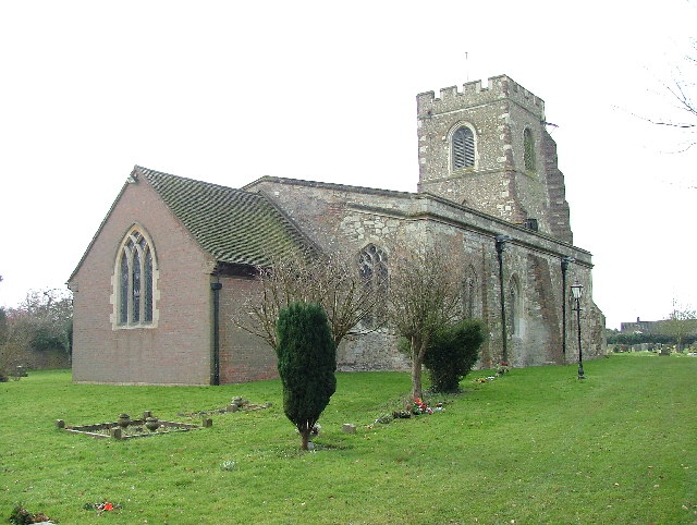
Church of St Margaret, Streatley, Bedfordshire

Church of St Margaret is a Grade I listed church in Streatley, Bedfordshire, England. It became a listed building on 3 February 1967. == See also == Grade...

Streatley, Bedfordshire

Streatley is a village and civil parish in the Central Bedfordshire district of Bedfordshire, England. == Geography == Streatley is situated just to the...

Smithcombe, Sharpenhoe and Sundon Hills

Smithcombe, Sharpenhoe and Sundon Hills is an 86.1-hectare (213-acre) Site of Special Scientific Interest in Sharpenhoe in Bedfordshire. Most of it is...

Nearby Amenities

Located within 500m of 51.949052,-0.45695442
Man Made: tower
Source: Bing
Tower Type: communication
Lat/Long: 51.9485612/-0.4497829
The data included in this document is from www.openstreetmap.org. The data is made available under ODbL.

Have you been to Fernhill Wood?

Leave your review of Fernhill Wood below (or comments, questions and feedback).