Brickyard Plantation

Wood, Forest in Lincolnshire South Kesteven

England

Brickyard Plantation

Countryside at dusk
Countryside at dusk Credit: Bob Harvey

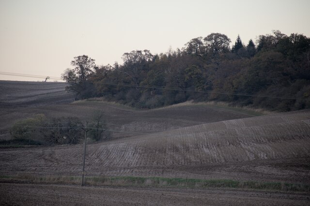
Brickyard Plantation, located in Lincolnshire, is a picturesque woodland area known for its rich biodiversity and scenic beauty. The plantation spans across a vast area, encompassing dense forests and woodlands. It is a popular destination for nature enthusiasts, hikers, and wildlife photographers.

The woodland in Brickyard Plantation is predominantly composed of native tree species such as oak, birch, and beech, creating a serene and tranquil atmosphere. The lush canopy provides a habitat for a wide variety of flora and fauna, making it a haven for wildlife. Visitors can spot deer, foxes, rabbits, and a plethora of bird species while exploring the plantation.

The plantation offers numerous walking trails, allowing visitors to immerse themselves in the natural beauty of the area. These trails are well-maintained and provide easy access to different parts of the woodland. Along the way, visitors can enjoy breathtaking views of meandering streams, vibrant wildflowers, and ancient trees.

Additionally, Brickyard Plantation is committed to environmental conservation and sustainable practices. The management team actively works to preserve the natural ecosystem and protect endangered species. They organize educational programs and awareness campaigns to promote environmental responsibility among visitors.

Overall, Brickyard Plantation in Lincolnshire is a true gem for nature lovers. It offers a peaceful retreat from the hustle and bustle of city life, allowing visitors to reconnect with nature and enjoy the beauty of the British countryside.

If you have any feedback on the listing, please let us know in the comments section below.

Brickyard Plantation Images

Images are sourced within 2km of 52.753964/-0.49715371 or Grid Reference TF0118. Thanks to Geograph Open Source API. All images are credited.

Countryside at dusk
Countryside at dusk
Viaduct, Little Bytham The giant Great Northern Railway viaduct looms large in this small village, and still carries the main East Coast line. It appears to be built of blue engineering brick. I haven't found a date beyond that it is Victorian.
Viaduct, Little Bytham
The giant Great Northern Railway viaduct looms large in this small village, and still carries the main East Coast line. It appears to be built of blue engineering brick. I haven't found a date beyond that it is Victorian.
Country road near Little Bytham
Willoughby Arms, Little Bytham Quite an imposing country pub which originally lay close to a railway station (<a href="https://www.geograph.org.uk/photo/4426796">TF0117 : The Willoughby Arms at Little Bytham, near Bourne, Lincolnshire</a>).
Willoughby Arms, Little Bytham
Quite an imposing country pub which originally lay close to a railway station (TF0117 : The Willoughby Arms at Little Bytham, near Bourne, Lincolnshire).
Getting ready For the last 4 months "works entrance" signs have been appearing in field entrances all over the area, wherever the 400kV lines cross a lane, road, or track.  Now they have started to erect these scaffolds.
Getting ready
For the last 4 months "works entrance" signs have been appearing in field entrances all over the area, wherever the 400kV lines cross a lane, road, or track. Now they have started to erect these scaffolds.
Little Bytham High Street Looking through the road arch of the magnificent Victorian railway viaduct that carries the 4-track East Coast Main Line over the village <a href="https://www.geograph.org.uk/photo/1622243">TF0118 : Railway Viaduct, Little Bytham</a>. The spire of the Church of St. Medard and St. Gildard is in the distance.
Little Bytham High Street
Looking through the road arch of the magnificent Victorian railway viaduct that carries the 4-track East Coast Main Line over the village TF0118 : Railway Viaduct, Little Bytham. The spire of the Church of St. Medard and St. Gildard is in the distance.
At the garden centre  Rassels in Little Bytham.
At the garden centre
Rassels in Little Bytham.
In the hothouse  Annual plants grown on for sale
In the hothouse
Annual plants grown on for sale
Railway bridge on Station Road, Little Bytham
Under the railway bridge on Station Road, Little Bytham
Station Road, Little Bytham
High Street, Little Bytham
The Spinney, Little Bytham Looking towards Foxholes Corner Plantation.
The Spinney, Little Bytham
Looking towards Foxholes Corner Plantation.
Little Bytham: signpost and autumn sunlight The winding B1176 links Grantham (left) and Stamford. The discoloured finger of the signpost points to Witham on the Hill and Bourne.
Little Bytham: signpost and autumn sunlight
The winding B1176 links Grantham (left) and Stamford. The discoloured finger of the signpost points to Witham on the Hill and Bourne.
Little Bytham: roads, roofers and an abandoned railway The bridge and the embankments each side once carried the line from Saxby Junction, near Melton Mowbray, to Bourne, which closed early in 1959. This was part of the Midland & Great Northern system, which carried holidaymakers from the Midlands to the Norfolk coast. This line crossed the East Coast Main Line at right angles on a girder bridge which was removed years ago. The gardens of the houses on the left end at the embankment which carries the ECML (see the map extract which accompanies this Geograph image).
Little Bytham: roads, roofers and an abandoned railway
The bridge and the embankments each side once carried the line from Saxby Junction, near Melton Mowbray, to Bourne, which closed early in 1959. This was part of the Midland & Great Northern system, which carried holidaymakers from the Midlands to the Norfolk coast. This line crossed the East Coast Main Line at right angles on a girder bridge which was removed years ago. The gardens of the houses on the left end at the embankment which carries the ECML (see the map extract which accompanies this Geograph image).
Little Bytham: Mulberry Motor Company Part of a small industrial estate in the lee of the East Coast Main Line railway embankment. The railway's overhead electric wires show above these buildings.
Little Bytham: Mulberry Motor Company
Part of a small industrial estate in the lee of the East Coast Main Line railway embankment. The railway's overhead electric wires show above these buildings.
Little Bytham: under the East Coast Main Line The railway crosses the B1176 from Stamford to Grantham (ahead). The bridge was built to carry two tracks and later extended each side to carry the current four. 

(The line south from Stoke Summit near Grantham was the stretch of the line on which, in 1938, the engine "Mallard" set the world speed record for a steam locomotive. It had to slow hereabouts because of the sharper curves at the next station to the south, Essendine.)
Little Bytham: under the East Coast Main Line
The railway crosses the B1176 from Stamford to Grantham (ahead). The bridge was built to carry two tracks and later extended each side to carry the current four. (The line south from Stoke Summit near Grantham was the stretch of the line on which, in 1938, the engine "Mallard" set the world speed record for a steam locomotive. It had to slow hereabouts because of the sharper curves at the next station to the south, Essendine.)
Queen Victoria 60 year reign commemorative plaque This stone plaque, by the roadside, is let into a stone wall by Millington's Farm.
It commemorates Queen Victoria's Diamond Jubilee - 60 years reign 1837-1897.
Queen Victoria 60 year reign commemorative plaque
This stone plaque, by the roadside, is let into a stone wall by Millington's Farm. It commemorates Queen Victoria's Diamond Jubilee - 60 years reign 1837-1897.
Show me another place!

Brickyard Plantation is located at Grid Ref: TF0118 (Lat: 52.753964, Lng: -0.49715371)

Administrative County: Lincolnshire

District: South Kesteven

Police Authority: Lincolnshire

What 3 Words

///hired.overlaid.origins. Near Clipsham, Rutland

Related Wikis

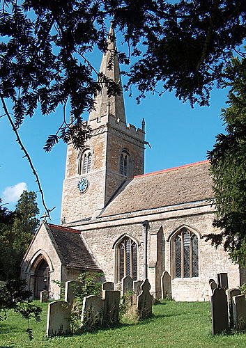
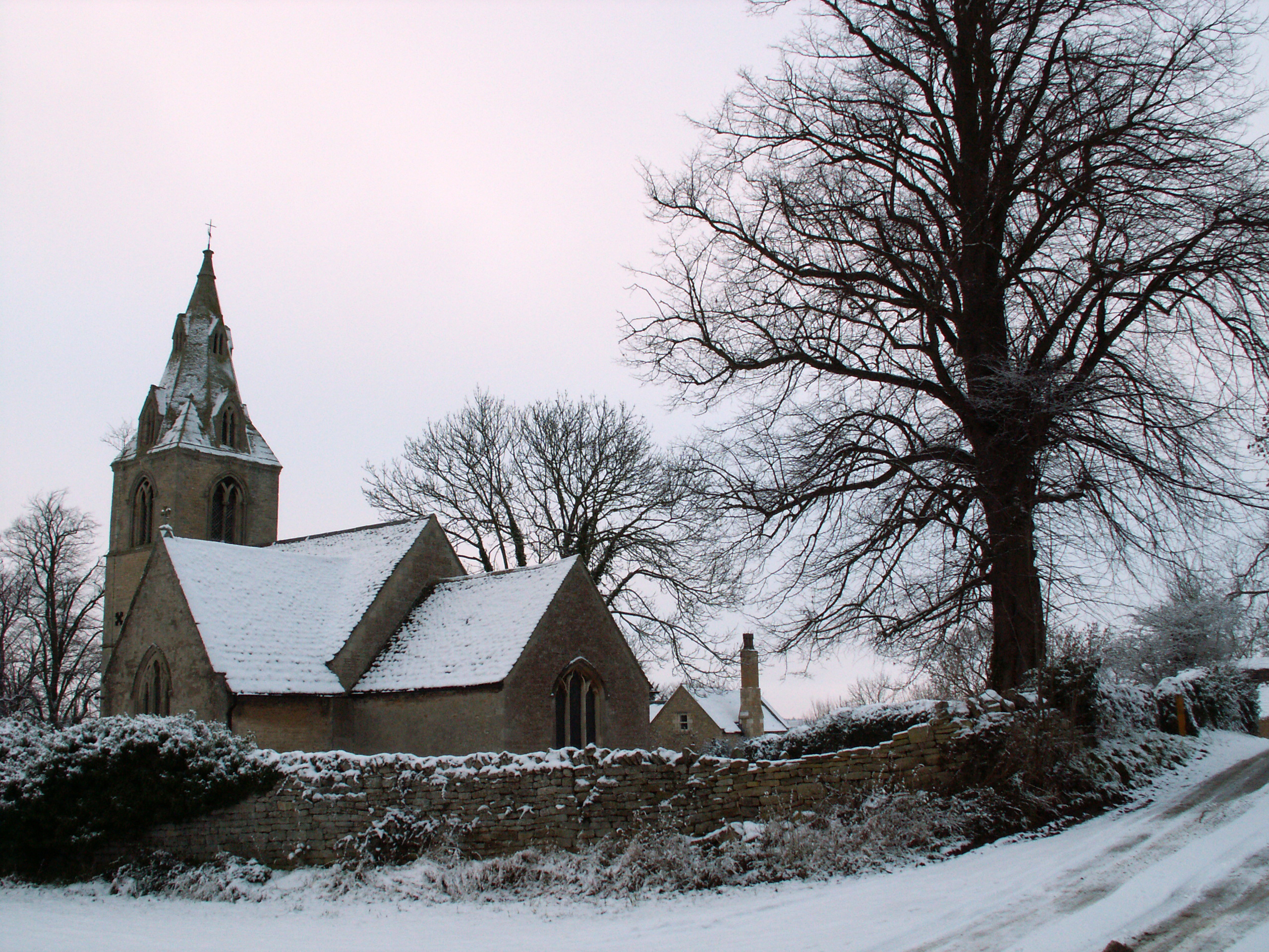
St Medardus and St Gildardus Church, Little Bytham

The church of St Medardus and St Gildardus in Little Bytham, Lincolnshire, England, is a Grade I listed building. It is dedicated to two 6th-century French...

Little Bytham

Little Bytham is a village and civil parish in the South Kesteven district of Lincolnshire, England. The population of the civil parish at the 2011 census...

Little Bytham railway station

Little Bytham railway station was a station in Little Bytham, Lincolnshire on the Great Northern Railway main line. It closed in 1959. The Midland and...

Creeton

Creeton is a village in the civil parish of Counthorpe and Creeton in the South Kesteven district of Lincolnshire, England. It is situated 3 miles (5 km...

Nearby Amenities

Located within 500m of 52.753964,-0.49715371
Little Bytham
Is In: Lincolnshire, England, UK
Place: village
Source: NPE
Lat/Long: 52.7509282/-0.4985459
Bus Stop
The Mallard PH
Naptan AtcoCode: 270000010073
Naptan Bearing: NE
Naptan CommonName: The Mallard PH
Naptan Indicator: opp
Naptan Landmark: The Mallard PH
Naptan NaptanCode: linjgtgd
Naptan Street: High Street
Naptan Verified: no
Source: naptan_import
Lat/Long: 52.7511372/-0.4977695
Bus Stop
River Bridge
Naptan AtcoCode: 270000014565
Naptan Bearing: SE
Naptan CommonName: River Bridge
Naptan Indicator: SE - bound
Naptan Landmark: River Bridge
Naptan NaptanCode: linjpwmw
Naptan Street: Station Road
Naptan Verified: no
Source: naptan_import
Lat/Long: 52.750237/-0.4976819
Bus Stop
River Bridge
Naptan AtcoCode: 270000014566
Naptan Bearing: NW
Naptan CommonName: River Bridge
Naptan Indicator: NW - bound
Naptan Landmark: River Bridge
Naptan NaptanCode: linjpwpa
Naptan Street: Station Road
Naptan Verified: no
Source: naptan_import
Lat/Long: 52.7502303/-0.49786
Bus Stop
The Mallard PH
Naptan AtcoCode: 2700LLBM1883
Naptan Bearing: SW
Naptan CommonName: The Mallard PH
Naptan Indicator: adj
Naptan Landmark: The Mallard PH
Naptan NaptanCode: linamwag
Naptan Street: High Street
Naptan Verified: no
Source: naptan_import
Lat/Long: 52.7510731/-0.4976828
Ford: yes
Lat/Long: 52.7511365/-0.4959961
Noexit: yes
Lat/Long: 52.7523208/-0.494624
Ele: 43.0000000
Lat/Long: 52.7546964/-0.4966765
Ele: 41.0000000
Lat/Long: 52.7531509/-0.4960328
Ele: 32.0000000
Removed Amenity: telephone
Lat/Long: 52.750956/-0.4979318
The Spinney
Tourism: picnic_site
Lat/Long: 52.7546292/-0.4971136
Post Box
Location: High Street
Operator: Royal Mail
Lat/Long: 52.750271/-0.5001756
Post Box
Location: Station Road
Operator: Royal Mail
Lat/Long: 52.7499072/-0.4973536
Oak Tree Farm
Place: farm
Source: Bing
Lat/Long: 52.7573146/-0.5008624
Place: farm
Lat/Long: 52.7516852/-0.4988698
Place: farm
Lat/Long: 52.7505943/-0.5016593
Stop
Direction: forward
Lat/Long: 52.7509128/-0.4982203
Power: pole
Lat/Long: 52.7507525/-0.4948234
Power: pole
Lat/Long: 52.750246/-0.4936271
Power: pole
Lat/Long: 52.7531808/-0.4954121
Power: pole
Lat/Long: 52.7532708/-0.4954085
The data included in this document is from www.openstreetmap.org. The data is made available under ODbL.

Have you been to Brickyard Plantation?

Leave your review of Brickyard Plantation below (or comments, questions and feedback).