Northbrook Copse

Wood, Forest in Surrey Waverley

England

Northbrook Copse

Downs Link near Cranleigh The Downs Link path follows a dismantled railway line for most of its length.  It also forms part of route 223 of the National Cycle Network.

Here, a bridge carries a road across the former railway.
Downs Link near Cranleigh Credit: Malc McDonald

Northbrook Copse is a picturesque woodland located in the county of Surrey, England. Covering an area of approximately 20 hectares, this enchanting forest is a natural haven that offers tranquility and beauty to visitors.

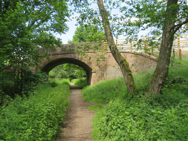
Situated near the village of Farnham, Northbrook Copse is characterized by its diverse range of tree species, including oak, beech, and holly. The forest floor is adorned with an array of vibrant wildflowers, creating a colorful tapestry throughout the seasons. The copse is also home to a variety of wildlife, such as deer, squirrels, and a myriad of bird species, providing ample opportunities for nature enthusiasts and photographers to observe and capture the beauty of the area.

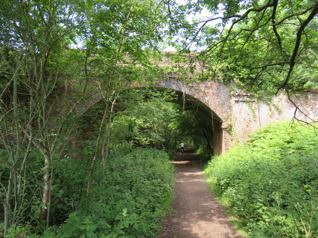
A network of well-maintained footpaths crisscrosses Northbrook Copse, inviting visitors to explore its hidden treasures. These paths lead through ancient woodlands, alongside babbling brooks, and up gentle slopes, offering breathtaking views of the surrounding countryside. Whether it be a leisurely stroll, a family picnic, or a peaceful spot for contemplation, this woodland caters to various outdoor activities.

Northbrook Copse is a popular destination for nature lovers and walkers alike. Its proximity to Farnham town means that it is easily accessible for both locals and tourists. The copse is open to the public year-round, with no entrance fee, ensuring that everyone can enjoy the natural beauty it has to offer.

In summary, Northbrook Copse in Surrey is a captivating woodland that showcases the true essence of nature. With its diverse flora and fauna, well-maintained footpaths, and tranquil atmosphere, it is a sanctuary for anyone seeking solace in the great outdoors.

If you have any feedback on the listing, please let us know in the comments section below.

Northbrook Copse Images

Images are sourced within 2km of 51.165068/-0.55357047 or Grid Reference TQ0141. Thanks to Geograph Open Source API. All images are credited.

Downs Link near Cranleigh The Downs Link path follows a dismantled railway line for most of its length.  It also forms part of route 223 of the National Cycle Network.

Here, a bridge carries a road across the former railway.
Downs Link near Cranleigh
The Downs Link path follows a dismantled railway line for most of its length. It also forms part of route 223 of the National Cycle Network. Here, a bridge carries a road across the former railway.
Downs Link near Cranleigh The Downs Link path follows a dismantled railway line for most of its length.  It also forms part of route 223 of the National Cycle Network.

Here, a bridge carries the path over a farm track.
Downs Link near Cranleigh
The Downs Link path follows a dismantled railway line for most of its length. It also forms part of route 223 of the National Cycle Network. Here, a bridge carries the path over a farm track.
Farm track near Cranleigh A farm track in Surrey countryside, near Cranleigh.
Farm track near Cranleigh
A farm track in Surrey countryside, near Cranleigh.
Downs Link near Cranleigh The Downs Link path follows a dismantled railway line for most of its length.  It also forms part of route 223 of the National Cycle Network.

The bridge ahead carries a farm track over the former railway route.
Downs Link near Cranleigh
The Downs Link path follows a dismantled railway line for most of its length. It also forms part of route 223 of the National Cycle Network. The bridge ahead carries a farm track over the former railway route.
Bridge over the Downs Link path near Cranleigh The Downs Link path follows a dismantled railway line for most of its length.  It also forms part of route 223 of the National Cycle Network.

The bridge was built to carry a farm track over the railway line.
Bridge over the Downs Link path near Cranleigh
The Downs Link path follows a dismantled railway line for most of its length. It also forms part of route 223 of the National Cycle Network. The bridge was built to carry a farm track over the railway line.
National Cycle Network route 22 near Bramley This path, shared by pedestrians and cyclists, forms part of National Cycle Network route 22.  The bridge ahead carries the Downs Link path, on a former railway alignment, across the path.
National Cycle Network route 22 near Bramley
This path, shared by pedestrians and cyclists, forms part of National Cycle Network route 22. The bridge ahead carries the Downs Link path, on a former railway alignment, across the path.
Bramley - Canal Restoration Works Excavation in progress by the Wey & Arun Canal Trust south of Bramley and adjacent to the Downslink footpath.
<span class="nowrap"><a title="www.weyarun.org.uk" rel="nofollow ugc noopener" href="http://www.weyarun.org.uk">Link</a><img style="margin-left:2px;" alt="External link" title="External link - shift click to open in new window" src="https://s1.geograph.org.uk/img/external.png" width="10" height="10"/></span>
Bramley - Canal Restoration Works
Excavation in progress by the Wey & Arun Canal Trust south of Bramley and adjacent to the Downslink footpath. LinkExternal link
Birtley Green - Greensand Way Wide path heading from the Downslink towards Rooks Hill Farm.
Birtley Green - Greensand Way
Wide path heading from the Downslink towards Rooks Hill Farm.
Shamley Green - Footbridge This substantial wooden footbridge is losing its supports on the Shamley Green bank of the brook.
Shamley Green - Footbridge
This substantial wooden footbridge is losing its supports on the Shamley Green bank of the brook.
Shamley Green - River Bank Erosion This substantial wooden footbridge is losing its concrete supports on the Shamley Green bank of the brook.
Shamley Green - River Bank Erosion
This substantial wooden footbridge is losing its concrete supports on the Shamley Green bank of the brook.
Winkworth - Valleyside View of the hillside to the east of Rowes Flash, an artificial lake in the valley bottom at Winkworth Arboretum.
<span class="nowrap"><a title="www.nationaltrust.org.uk" rel="nofollow ugc noopener" href="http://www.nationaltrust.org.uk">Link</a><img style="margin-left:2px;" alt="External link" title="External link - shift click to open in new window" src="https://s1.geograph.org.uk/img/external.png" width="10" height="10"/></span>
Winkworth - Valleyside
View of the hillside to the east of Rowes Flash, an artificial lake in the valley bottom at Winkworth Arboretum. LinkExternal link
Winkworth Arboretum - Snowman Trail "Ten Lords a-Leaping", decorated snowman number 10 on the festive trail for Christmas 2022 - with a female lord to appease the politically correct folk.
<span class="nowrap"><a title="www.nationaltrust.org.uk" rel="nofollow ugc noopener" href="http://www.nationaltrust.org.uk">Link</a><img style="margin-left:2px;" alt="External link" title="External link - shift click to open in new window" src="https://s1.geograph.org.uk/img/external.png" width="10" height="10"/></span>
Winkworth Arboretum - Snowman Trail
"Ten Lords a-Leaping", decorated snowman number 10 on the festive trail for Christmas 2022 - with a female lord to appease the politically correct folk. LinkExternal link
Winkworth Arboretum - Snowman Trail "Flying in the Air" - figures from "The Snowman" story by Raymond Briggs - on the festive snowman trail for Christmas 2022.
<span class="nowrap"><a title="www.nationaltrust.org.uk" rel="nofollow ugc noopener" href="http://www.nationaltrust.org.uk">Link</a><img style="margin-left:2px;" alt="External link" title="External link - shift click to open in new window" src="https://s1.geograph.org.uk/img/external.png" width="10" height="10"/></span>
Winkworth Arboretum - Snowman Trail
"Flying in the Air" - figures from "The Snowman" story by Raymond Briggs - on the festive snowman trail for Christmas 2022. LinkExternal link
Winkworth Arboretum - "The Snowman" "Flying in the Air" - figure from "The Snowman" story by Raymond Briggs - on the festive snowman trail for Christmas 2022.
<span class="nowrap"><a title="www.nationaltrust.org.uk" rel="nofollow ugc noopener" href="http://www.nationaltrust.org.uk">Link</a><img style="margin-left:2px;" alt="External link" title="External link - shift click to open in new window" src="https://s1.geograph.org.uk/img/external.png" width="10" height="10"/></span>
Winkworth Arboretum - "The Snowman"
"Flying in the Air" - figure from "The Snowman" story by Raymond Briggs - on the festive snowman trail for Christmas 2022. LinkExternal link
Winkworth Arboretum - Snowman Trail "Eleven Pipers Piping", decorated snowman number 11 on the festive trail for Christmas 2022.
<span class="nowrap"><a title="www.nationaltrust.org.uk" rel="nofollow ugc noopener" href="http://www.nationaltrust.org.uk">Link</a><img style="margin-left:2px;" alt="External link" title="External link - shift click to open in new window" src="https://s1.geograph.org.uk/img/external.png" width="10" height="10"/></span>
Winkworth Arboretum - Snowman Trail
"Eleven Pipers Piping", decorated snowman number 11 on the festive trail for Christmas 2022. LinkExternal link
Winkworth Arboretum - Snowman Trail "Eleven Pipers Piping", decorated snowman number 11 on the popular festive trail through woodland, Christmas 2022.
<span class="nowrap"><a title="www.nationaltrust.org.uk" rel="nofollow ugc noopener" href="http://www.nationaltrust.org.uk">Link</a><img style="margin-left:2px;" alt="External link" title="External link - shift click to open in new window" src="https://s1.geograph.org.uk/img/external.png" width="10" height="10"/></span>
Winkworth Arboretum - Snowman Trail
"Eleven Pipers Piping", decorated snowman number 11 on the popular festive trail through woodland, Christmas 2022. LinkExternal link
Winkworth Arboretum - Rowe's Flashe Artificial lake in the valley bottom at this National Trust woodland attraction.
The fallen tree trunk is now being colonised by ferns and grasses.
<span class="nowrap"><a title="www.nationaltrust.org.uk" rel="nofollow ugc noopener" href="http://www.nationaltrust.org.uk">Link</a><img style="margin-left:2px;" alt="External link" title="External link - shift click to open in new window" src="https://s1.geograph.org.uk/img/external.png" width="10" height="10"/></span>
Winkworth Arboretum - Rowe's Flashe
Artificial lake in the valley bottom at this National Trust woodland attraction. The fallen tree trunk is now being colonised by ferns and grasses. LinkExternal link
Winkworth Arboretum - Boat House This boat house is open to arboretum visitors and gives a different vista of this artificial lake, Rowe's Flashe.
<span class="nowrap"><a title="www.nationaltrust.org.uk" rel="nofollow ugc noopener" href="http://www.nationaltrust.org.uk">Link</a><img style="margin-left:2px;" alt="External link" title="External link - shift click to open in new window" src="https://s1.geograph.org.uk/img/external.png" width="10" height="10"/></span>
Winkworth Arboretum - Boat House
This boat house is open to arboretum visitors and gives a different vista of this artificial lake, Rowe's Flashe. LinkExternal link
Show me another place!

Northbrook Copse is located at Grid Ref: TQ0141 (Lat: 51.165068, Lng: -0.55357047)

Administrative County: Surrey

District: Waverley

Police Authority: Surrey

What 3 Words

///glider.hacking.sunflower. Near Bramley, Surrey

Related Wikis

Winkworth Arboretum

Winkworth Arboretum is a National Trust-owned arboretum in the spread-out civil parish of Busbridge between Godalming and Hascombe, south-west Surrey,...

Hascombe

Hascombe is a village and civil parish in Surrey, England. It is around 3 miles (4.8 km) southeast of Godalming in the Borough of Waverley. The settlement...

Orchards, Surrey

Orchards is an Arts and Crafts style house in Bramley in Surrey, England. It is on Bramley's boundary with Busbridge and 1 mile (1.6 km) south-east of...

Hascombe Court

Hascombe Court is a 172-acre (70 ha) estate in Hascombe, Surrey, best known for its vast garden designed by Gertrude Jekyll. Hascombe Court is listed Grade...

Christ Church, Shamley Green

Christ Church is a Church of England parish church in Shamley Green, Surrey, England. It was constructed in 1863 as a chapel of ease and became a parish...

Munstead Wood

Munstead Wood is a Grade I listed house and garden in Munstead Heath, Busbridge on the boundary of the town of Godalming in Surrey, England, 1 mile (1...

Bramley, Surrey

Bramley is a village and civil parish about three miles (5 km) south of Guildford in the Borough of Waverley in Surrey, south east England. Most of the...

Hascombe Hill

Hascombe Hill or Hascombe Camp is the site of an Iron Age multivallate hill fort close to the village of Hascombe in Surrey, England. == History == The...

Nearby Amenities

Located within 500m of 51.165068,-0.55357047
Winters Hall
Building: yes
Source: npe
Wikidata: Q26413035
Lat/Long: 51.1628292/-0.5538148
Barrier: stile
Lat/Long: 51.168244/-0.5491229
Barrier: stile
Lat/Long: 51.1668396/-0.5472256
Barrier: stile
Material: wood
Step Count: 1
Stile: stepover
Lat/Long: 51.165494/-0.5471974
Source: survey
Traffic Calming: bump
Lat/Long: 51.1686304/-0.5499686
Addr Housename: The Oast House
Building: yes
Source: survey
Lat/Long: 51.1679876/-0.5499795
Natural: spring
Lat/Long: 51.1686306/-0.5539201
Natural: spring
Lat/Long: 51.1688862/-0.554655
Power: pole
Lat/Long: 51.1648465/-0.5481429
Power: pole
Lat/Long: 51.1656051/-0.5482207
Power: pole
Lat/Long: 51.1665907/-0.5482958
Gate Street Farm
Place: farm
Lat/Long: 51.1670926/-0.5535519
The data included in this document is from www.openstreetmap.org. The data is made available under ODbL.

Have you been to Northbrook Copse?

Leave your review of Northbrook Copse below (or comments, questions and feedback).