Great Wood

Wood, Forest in Bedfordshire

England

Great Wood

Footpath to Water End Lane Though you need to be quite determined to use it without climbing over the gate
Footpath to Water End Lane Credit: Philip Jeffrey

Great Wood is a sprawling forest located in Bedfordshire, England. Covering an area of approximately 1,000 acres, it is a popular destination for nature enthusiasts and outdoor adventurers. The forest is situated amidst the picturesque landscape of the Bedfordshire countryside, offering visitors a tranquil and serene environment.

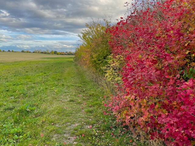
Great Wood boasts a diverse range of plant and animal species, making it an important ecological site. The forest is predominantly comprised of native deciduous trees, such as oak, ash, and birch, which provide a rich habitat for various wildlife. Visitors can spot a wide array of bird species, including woodpeckers, owls, and thrushes, as well as mammals like deer, foxes, and squirrels.

The woodland is crisscrossed with a network of walking trails, allowing visitors to explore the forest at their own pace. These paths wind through the trees, providing breathtaking views of the surrounding countryside. There are also designated picnic areas and benches, making it an ideal spot for a leisurely outdoor meal or a moment of relaxation.

Great Wood is managed by the local forestry commission, which ensures the preservation of its natural beauty and protects its delicate ecosystem. They regularly undertake conservation projects, such as tree planting and habitat restoration, to maintain the forest's biodiversity.

Overall, Great Wood in Bedfordshire is a haven for nature lovers, offering a peaceful retreat from the hustle and bustle of daily life. Its stunning landscape, diverse wildlife, and well-maintained trails make it an ideal destination for a day out in nature.

If you have any feedback on the listing, please let us know in the comments section below.

Great Wood Images

Images are sourced within 2km of 51.928678/-0.53369032 or Grid Reference TL0026. Thanks to Geograph Open Source API. All images are credited.

Footpath to Water End Lane Though you need to be quite determined to use it without climbing over the gate
Footpath to Water End Lane
Though you need to be quite determined to use it without climbing over the gate
Entrance to the sewage works
Houses on Leighton Road, Toddington
House building north of Houghton Regis
Pylons by the North Dunstable Bypass
Trees on the Ickniekd Way
Dilapidated barn at Bidwell
Dunstable Rugby Club
Curious sheep on the footpath
Autumnal hedge on the Chiltern Way
Chalgrave Memorial Hall, Tebworth I'm not sure why this village hall is named after Chalgrave when it is situated in the village of Tebworth on the lane to Wingfield !
It looks to be quite a new construction, so perhaps it replaced an earlier hall near to Chalgrave itself (see <a href="https://www.geograph.org.uk/photo/116127">TL0027 : All Saints, Chalgrave : Chequered Stonework</a>)
[Edit - extra information from "sarah"] There never was a Chalgrave village proper; it's the parish name. The settlement/church known as Chalgrave was Saxon East Coton, and became known as Chalgrave for the Manor adjacent to it (which eventually gave its name to the parish). The Memorial Hall is probably named for the Parish, not the village. There'll shortly be a Chalgrave Heritage Trail and set of information boards that (I hope) will explain this and more.
Chalgrave Memorial Hall, Tebworth
I'm not sure why this village hall is named after Chalgrave when it is situated in the village of Tebworth on the lane to Wingfield ! It looks to be quite a new construction, so perhaps it replaced an earlier hall near to Chalgrave itself (see TL0027 : All Saints, Chalgrave : Chequered Stonework) [Edit - extra information from "sarah"] There never was a Chalgrave village proper; it's the parish name. The settlement/church known as Chalgrave was Saxon East Coton, and became known as Chalgrave for the Manor adjacent to it (which eventually gave its name to the parish). The Memorial Hall is probably named for the Parish, not the village. There'll shortly be a Chalgrave Heritage Trail and set of information boards that (I hope) will explain this and more.
Sunny shorn sheep I reckon that these sheep are very pleased to have been shorn of their woolly coats as the temperature when I took this photo was in the mid nineties ºF ( = mid thirties ºC) - absolutely baking. The strands to be seen at the top of the picture are the cables of the National Grid electricity line which crosses the land just south of this point.
Sunny shorn sheep
I reckon that these sheep are very pleased to have been shorn of their woolly coats as the temperature when I took this photo was in the mid nineties ºF ( = mid thirties ºC) - absolutely baking. The strands to be seen at the top of the picture are the cables of the National Grid electricity line which crosses the land just south of this point.
Stream north of Tebworth This little stream crosses beneath the Toddington Road north of Tebworth. It may well usually be more substantial than this trickle because the weather recently has been exceptionally dry. It is a little difficult to follow its course on the map, but I think that it eventually joins up with Clipstone Brook to the west.
Stream north of Tebworth
This little stream crosses beneath the Toddington Road north of Tebworth. It may well usually be more substantial than this trickle because the weather recently has been exceptionally dry. It is a little difficult to follow its course on the map, but I think that it eventually joins up with Clipstone Brook to the west.
Boundary hedge north of Tebworth This hedge and the two trees pictured mark the route of a stream (see <a href="https://www.geograph.org.uk/photo/204810">SP9927 : Stream north of Tebworth</a>) which flows between two fields. On the far side of the hedge is a footpath which hugs the stream's course too.
Boundary hedge north of Tebworth
This hedge and the two trees pictured mark the route of a stream (see SP9927 : Stream north of Tebworth) which flows between two fields. On the far side of the hedge is a footpath which hugs the stream's course too.
Tebworth Village House Several lanes come together in Tebworth and in the centre of the village a little island is formed by small lanes. This house is on the edge of one of the lanes forming the island. The brickwork colour and style reminds me of Victorian railway architecture, but I can see no sign of any abandoned railway line - perhaps they used a railway architect !
Tebworth Village House
Several lanes come together in Tebworth and in the centre of the village a little island is formed by small lanes. This house is on the edge of one of the lanes forming the island. The brickwork colour and style reminds me of Victorian railway architecture, but I can see no sign of any abandoned railway line - perhaps they used a railway architect !
The Queens Head, Tebworth A Charles Wells village local. Youngs beers now available too but sadly not from Wandsworth.
The Queens Head, Tebworth
A Charles Wells village local. Youngs beers now available too but sadly not from Wandsworth.
All Saints, Chalgrave According to the map this is a church "without tower or spire" - which seems a little unfair as it definitely has got a tower albeit a rather dumpy one ! This little church is off the beaten track down its own lane.
More information about the church and Chalgrave here <span class="nowrap"><a title="http://www.british-history.ac.uk/report.asp?compid=42446" rel="nofollow ugc noopener" href="http://www.british-history.ac.uk/report.asp?compid=42446">Link</a><img style="margin-left:2px;" alt="External link" title="External link - shift click to open in new window" src="https://s1.geograph.org.uk/img/external.png" width="10" height="10"/></span>
All Saints, Chalgrave
According to the map this is a church "without tower or spire" - which seems a little unfair as it definitely has got a tower albeit a rather dumpy one ! This little church is off the beaten track down its own lane. More information about the church and Chalgrave here LinkExternal link
All Saints, Chalgrave : Chequered Stonework A three-quarters shot of this attractive church showing the appealing chequered stone work, the solid little tower and interesting cylindrical turret. This church looks to be very well kept.
More information about Chalgrave and All Saints here <span class="nowrap"><a title="http://www.british-history.ac.uk/report.asp?compid=42446" rel="nofollow ugc noopener" href="http://www.british-history.ac.uk/report.asp?compid=42446">Link</a><img style="margin-left:2px;" alt="External link" title="External link - shift click to open in new window" src="https://s1.geograph.org.uk/img/external.png" width="10" height="10"/></span>
All Saints, Chalgrave : Chequered Stonework
A three-quarters shot of this attractive church showing the appealing chequered stone work, the solid little tower and interesting cylindrical turret. This church looks to be very well kept. More information about Chalgrave and All Saints here LinkExternal link
Show me another place!

Great Wood is located at Grid Ref: TL0026 (Lat: 51.928678, Lng: -0.53369032)

Unitary Authority: Central Bedfordshire

Police Authority: Bedfordshire

What 3 Words

///august.version.modifies. Near Chalton, Bedfordshire

Related Wikis

Chalgrave

Chalgrave is a civil parish in the Central Bedfordshire district of Bedfordshire, England. The hamlets of Tebworth and Wingfield are in the west of the...

Chalgrave Castle

Chalgrave Castle stood to the south of the large village of Toddington, Bedfordshire. This was a timber motte and bailey castle, constructed in two phases...

Church of All Saints, Chalgrave

The Church of All Saints is a Grade I listed church in Chalgrave, Bedfordshire, England. It became a listed building on 3 February 1967. The church, dedicated...

Wingfield, Bedfordshire

Wingfield is a hamlet located in the Central Bedfordshire district of Bedfordshire, England. The settlement is close to Tebworth and Chalgrave, with the...

Dropshort Marsh

Dropshort Marsh is a 2.7-hectare (6.7-acre) biological Site of Special Scientific Interest in Toddington in Bedfordshire. It was notified under Section...

Thorn, Bedfordshire

Thorn is a hamlet located in the Central Bedfordshire district of Bedfordshire, England. The settlement is located to the north of Bidwell and Houghton...

Fancott

Fancott is a hamlet located in the Central Bedfordshire district of Bedfordshire, England.The settlement forms part of the Toddington civil parish, and...

Tebworth

Tebworth is a hamlet located in the Central Bedfordshire district of Bedfordshire, England. The settlement is close to Wingfield and Hockliffe, with the...

Nearby Amenities

Located within 500m of 51.928678,-0.53369032
Power: tower
Lat/Long: 51.9321158/-0.5312896
Building: yes
Lat/Long: 51.9275466/-0.534374
Barrier: stile
Bicycle: no
Foot: designated
Horse: no
Motor Vehicle: no
Lat/Long: 51.9276917/-0.5406246
Power: pole
Lat/Long: 51.930679/-0.5279458
The data included in this document is from www.openstreetmap.org. The data is made available under ODbL.

Have you been to Great Wood?

Leave your review of Great Wood below (or comments, questions and feedback).