Gallions Wood

Wood, Forest in Buckinghamshire

England

Gallions Wood

Memorial of Thomas Gray The memorial of Thomas Gray - erected in 1788. <span class="nowrap"><a title="http://www.poetsgraves.co.uk/gray.htm" rel="nofollow ugc noopener" href="http://www.poetsgraves.co.uk/gray.htm">Link</a><img style="margin-left:2px;" alt="External link" title="External link - shift click to open in new window" src="https://s1.geograph.org.uk/img/external.png" width="10" height="10"/></span>
Memorial of Thomas Gray Credit: Jonathan Dew

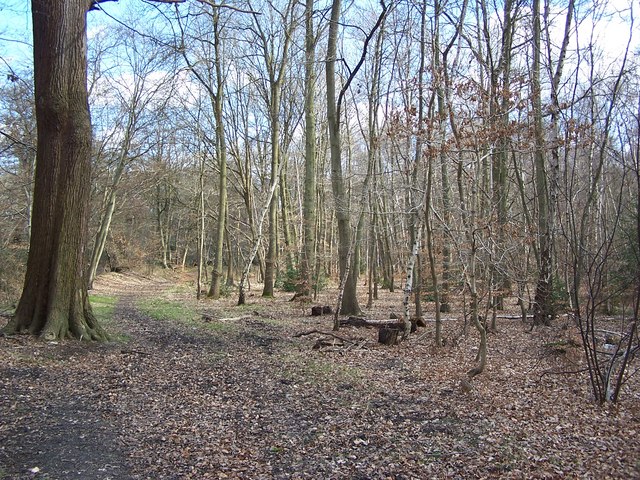
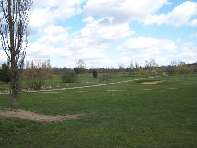
Gallions Wood is a picturesque forest located in Buckinghamshire, England. Covering an area of approximately 100 hectares, the wood is renowned for its natural beauty and diverse ecosystem. It is situated near the village of Farnham Common and is easily accessible to visitors.

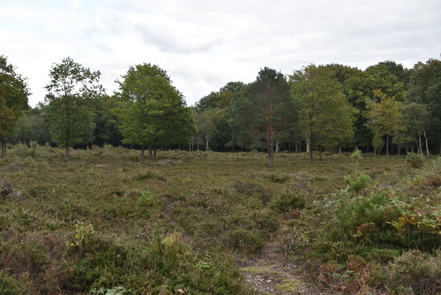
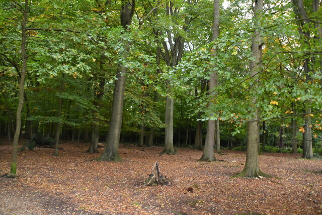
The wood is predominantly made up of broadleaf trees such as oak, beech, and birch, which create a stunning canopy overhead. These ancient trees provide a habitat for a wide range of wildlife, including deer, squirrels, and various bird species. The forest floor is adorned with an array of wildflowers, adding a burst of color to the surroundings.

Gallions Wood offers an ideal setting for nature lovers and outdoor enthusiasts. It is crisscrossed with numerous walking trails, allowing visitors to explore the area at their leisure. These paths wind through the forest, offering stunning views of the surrounding countryside and glimpses of wildlife along the way.

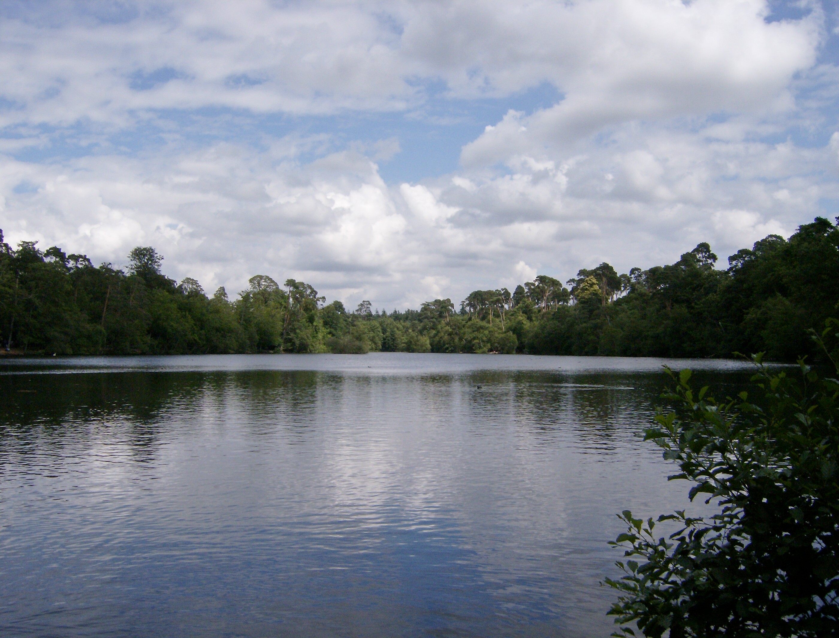
The wood is also home to a small pond, attracting various aquatic creatures and offering a peaceful spot for visitors to relax and observe nature. Additionally, there are picnic areas scattered throughout the forest, providing a perfect setting for families and friends to enjoy a leisurely meal amidst the tranquility of the woodland.

Managed by the local authorities, Gallions Wood ensures the preservation and protection of its natural environment. The forest offers a peaceful retreat from the hustle and bustle of everyday life, allowing visitors to connect with nature and enjoy the beauty it has to offer.

If you have any feedback on the listing, please let us know in the comments section below.

Gallions Wood Images

Images are sourced within 2km of 51.53746/-0.56469472 or Grid Reference SU9983. Thanks to Geograph Open Source API. All images are credited.

Memorial of Thomas Gray The memorial of Thomas Gray - erected in 1788. <span class="nowrap"><a title="http://www.poetsgraves.co.uk/gray.htm" rel="nofollow ugc noopener" href="http://www.poetsgraves.co.uk/gray.htm">Link</a><img style="margin-left:2px;" alt="External link" title="External link - shift click to open in new window" src="https://s1.geograph.org.uk/img/external.png" width="10" height="10"/></span>
Memorial of Thomas Gray
The memorial of Thomas Gray - erected in 1788. LinkExternal link
Outskirts of Slough From a footbridge over the A412 Uxbridge Road, looking south-west to Upton Lea and Slough. The crash barrier in the middle of the dual carriageway looks as if it has done its job and been bent in stopping a vehicle crossing.
Outskirts of Slough
From a footbridge over the A412 Uxbridge Road, looking south-west to Upton Lea and Slough. The crash barrier in the middle of the dual carriageway looks as if it has done its job and been bent in stopping a vehicle crossing.
Shops in Knolton Way, Slough The shops are in Knolton Way, photo looking west from the end of Moat Drive.
Shops in Knolton Way, Slough
The shops are in Knolton Way, photo looking west from the end of Moat Drive.
Houses in Church Lane, Stoke Green Looking north-east across Church Lane by the school, just at the corner of the grid square
Houses in Church Lane, Stoke Green
Looking north-east across Church Lane by the school, just at the corner of the grid square
Wexham Park Hospital, Stoke Green, Slough A large hospital spread out within the park. View north from Church Lane near Wexham Road.
Wexham Park Hospital, Stoke Green, Slough
A large hospital spread out within the park. View north from Church Lane near Wexham Road.
Rowley Wood - Path adjacent to Rowley Lane
Framewood Manor - Gatehouse
Sefton Park - Entrance
Houses East of Sefton Park Taken from Farthing Green Lane - looking North East
Houses East of Sefton Park
Taken from Farthing Green Lane - looking North East
Wexham Street - War Memorial
Stoke Poges - Village Centre
Wexham Park Golf Course
The Stag at Wexham Street
Rogers Lane, Stoke Poges Just west of the junction with the B416.
Rogers Lane, Stoke Poges
Just west of the junction with the B416.
Stoke Poges: The Rose & Crown public house A Greene King pub on the north side of Hollybush Hill.
Stoke Poges: The Rose & Crown public house
A Greene King pub on the north side of Hollybush Hill.
Wexham: St Mary's Church The oldest part of the church, the nave, dates from the 12th century, and the circular opening in the west wall, visible here, dates from that time. Below it the two-light window dates from the 15th century. The bell tower has wooden weatherboarding and a wooden spire above.

The church appears to stand in isolation from any other contemporary buildings, but the manor house of Wexham Court, now demolished, used to stand on the other side of Church Lane. Today the Wexham Court housing estate covers the area of the manor house.

The church was formerly known as St Mary the Virgin and its website is here <span class="nowrap"><a title="http://www.stmaryswexham.org.uk/" rel="nofollow ugc noopener" href="http://www.stmaryswexham.org.uk/">Link</a><img style="margin-left:2px;" alt="External link" title="External link - shift click to open in new window" src="https://s1.geograph.org.uk/img/external.png" width="10" height="10"/></span>
Wexham: St Mary's Church
The oldest part of the church, the nave, dates from the 12th century, and the circular opening in the west wall, visible here, dates from that time. Below it the two-light window dates from the 15th century. The bell tower has wooden weatherboarding and a wooden spire above. The church appears to stand in isolation from any other contemporary buildings, but the manor house of Wexham Court, now demolished, used to stand on the other side of Church Lane. Today the Wexham Court housing estate covers the area of the manor house. The church was formerly known as St Mary the Virgin and its website is here LinkExternal link
Heathland, Black Park Black Park is a 250 hectare country park in Buckinghamshire.
Wikipedia: <span class="nowrap"><a title="https://en.wikipedia.org/wiki/Black_Park" rel="nofollow ugc noopener" href="https://en.wikipedia.org/wiki/Black_Park">Link</a><img style="margin-left:2px;" alt="External link" title="External link - shift click to open in new window" src="https://s1.geograph.org.uk/img/external.png" width="10" height="10"/></span>
Heathland, Black Park
Black Park is a 250 hectare country park in Buckinghamshire. Wikipedia: LinkExternal link
Black Park
Black Park
Show me another place!

Gallions Wood is located at Grid Ref: SU9983 (Lat: 51.53746, Lng: -0.56469472)

Unitary Authority: Buckinghamshire

Police Authority: Thames Valley

What 3 Words

///fresh.punk.glue. Near Stoke Poges, Buckinghamshire

Related Wikis

Wexham

Wexham is a civil parish straddling the ceremonial counties of Berkshire and Buckinghamshire in southern England. Wexham Park Hospital is a large hospital...

Stoke and Wexham War Memorial

Stoke and Wexham War Memorial is located in Wexham Street, Wexham, Buckinghamshire, England. It is a grade II listed building with Historic England and...

Wexham Park Hospital

Wexham Park Hospital is a large NHS hospital in Slough, Berkshire. It has been managed by Frimley Health NHS Foundation Trust since 2014. Sir Andrew Morris...

Black Park

Black Park is a country park in Wexham, Buckinghamshire, England to the north of the A412 road. It is managed by Buckinghamshire Council, formerly County...

Wexham School

Wexham School is a co-educational community school in Wexham Court, Slough, Berkshire. == Admissions == The school opened in 1987, and serves students...

Teikyo School United Kingdom

Teikyo School United Kingdom (帝京ロンドン学園高等部, Teikyō Rondon Gakuen Kōtōbu, "Teikyo London Academy High School Division") is a Japanese international school...

Fulmer Research Institute

Fulmer Research Institute was founded in 1945 as a UK contract research and development organization specializing in materials technology and related areas...

Stoke Place

Stoke Place is a country house in Stoke Poges in Buckinghamshire. == Patrick Lamb == Patrick Lamb built Stoke Place in 1690. For about 50 years he was...

Nearby Amenities

Located within 500m of 51.53746,-0.56469472
Barrier: stile
Lat/Long: 51.5384487/-0.5652408
The data included in this document is from www.openstreetmap.org. The data is made available under ODbL.

Have you been to Gallions Wood?

Leave your review of Gallions Wood below (or comments, questions and feedback).