Greatfield Spinney

Wood, Forest in Bedfordshire

England

Greatfield Spinney

B5704 London Road towards Woburn
B5704 London Road towards Woburn Credit: Robin Webster

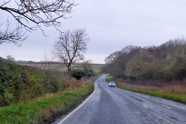
Greatfield Spinney is a picturesque woodland located in Bedfordshire, England. Covering an area of approximately 10 acres, it is a haven for nature enthusiasts and provides a peaceful retreat from the bustling city life of nearby Bedford. The spinney is situated on the outskirts of the village of Greatfield, surrounded by rolling hills and farmland.

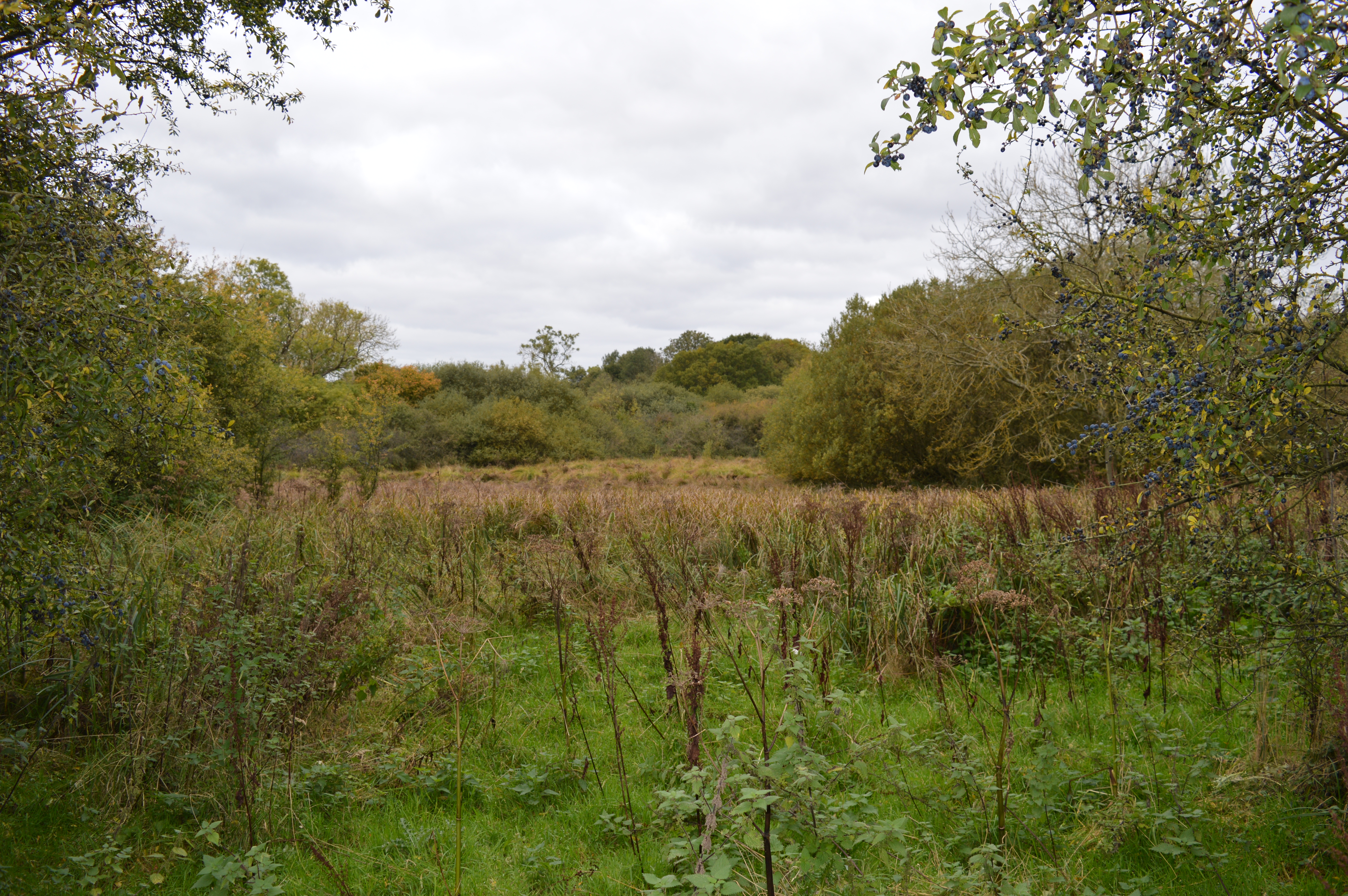
The woodland is predominantly made up of native broadleaf trees, including oak, ash, and beech, which create a dense canopy overhead. This provides a cool and shady environment, particularly during the summer months. The forest floor is covered in a thick layer of leaf litter and moss, creating a rich habitat for a variety of flora and fauna.

Greatfield Spinney is home to a diverse range of wildlife. Birdwatchers can spot species such as woodpeckers, owls, and thrushes, while small mammals like rabbits, squirrels, and badgers can often be seen foraging in the undergrowth. In the spring, the woodland comes alive with the vibrant colors of bluebells and wildflowers, attracting butterflies and bees.

The spinney is a popular destination for walkers and nature lovers, with a network of well-maintained footpaths meandering through the trees. Visitors can enjoy a peaceful stroll, taking in the sights and sounds of the woodland. There are also several benches scattered throughout the area, providing the perfect spot to sit and soak up the tranquility.

Overall, Greatfield Spinney is a beautiful and serene woodland, offering a slice of nature's tranquility in the heart of Bedfordshire.

If you have any feedback on the listing, please let us know in the comments section below.

Greatfield Spinney Images

Images are sourced within 2km of 51.960829/-0.57375803 or Grid Reference SP9830. Thanks to Geograph Open Source API. All images are credited.

B5704 London Road towards Woburn
Farmland, Milton Bryan A footpath through wheat to the north-east of the village.
Farmland, Milton Bryan
A footpath through wheat to the north-east of the village.
Farmland, Toddington Oats to the north-west of Happy Land Farm.
Farmland, Toddington
Oats to the north-west of Happy Land Farm.
Milton Wood This view of Milton Wood was taken from the Eastern edge of Fourteen Acre Spinney on the road from Eversholt to Milton Bryan.
Milton Wood
This view of Milton Wood was taken from the Eastern edge of Fourteen Acre Spinney on the road from Eversholt to Milton Bryan.
St. Peter, Milton Bryan Rather an unusual church this one. It is almost square with parts of wildly different ages and construction style - and it has a tower made of such closely keened pale stone that it looks like concrete. It is set in a garden-like churchyard. Definitely a one-off. I originally accidentally added a T to Bryan making it Bryant - curiously I now discover that that is an alternative disused name for the village. More info here - <span class="nowrap"><a title="http://www.bedfordshire.gov.uk/communityandliving/archivesandrecordoffice/communityarchives/miltonbryan/miltonbryanchurch.aspx" rel="nofollow ugc noopener" href="http://www.bedfordshire.gov.uk/communityandliving/archivesandrecordoffice/communityarchives/miltonbryan/miltonbryanchurch.aspx">Link</a><img style="margin-left:2px;" alt="External link" title="External link - shift click to open in new window" src="https://s1.geograph.org.uk/img/external.png" width="10" height="10"/></span> and <span class="nowrap"><a title="http://www.british-history.ac.uk/report.asp?compid=42456" rel="nofollow ugc noopener" href="http://www.british-history.ac.uk/report.asp?compid=42456">Link</a><img style="margin-left:2px;" alt="External link" title="External link - shift click to open in new window" src="https://s1.geograph.org.uk/img/external.png" width="10" height="10"/></span>
St. Peter, Milton Bryan
Rather an unusual church this one. It is almost square with parts of wildly different ages and construction style - and it has a tower made of such closely keened pale stone that it looks like concrete. It is set in a garden-like churchyard. Definitely a one-off. I originally accidentally added a T to Bryan making it Bryant - curiously I now discover that that is an alternative disused name for the village. More info here - LinkExternal link and LinkExternal link
St. Peter's church, Milton Bryan - Western end A close up of the Western end of St. Peter's church, Milton Bryan showing some of the mix of architectural styles and periods. This is a very odd-looking church. More info. here <span class="nowrap"><a title="http://www.british-history.ac.uk/report.asp?compid=42456#s3" rel="nofollow ugc noopener" href="http://www.british-history.ac.uk/report.asp?compid=42456#s3">Link</a><img style="margin-left:2px;" alt="External link" title="External link - shift click to open in new window" src="https://s1.geograph.org.uk/img/external.png" width="10" height="10"/></span>
St. Peter's church, Milton Bryan - Western end
A close up of the Western end of St. Peter's church, Milton Bryan showing some of the mix of architectural styles and periods. This is a very odd-looking church. More info. here LinkExternal link
Ford Spinney Taken from the A4012 near Battlesden
Ford Spinney
Taken from the A4012 near Battlesden
Hill Farm Sheep These sheep belong to Hill Farm which can be seen in the background. The lane abruptly ends just after this point with a private road continuing to the farm and a track leading to Battlesden.
Hill Farm Sheep
These sheep belong to Hill Farm which can be seen in the background. The lane abruptly ends just after this point with a private road continuing to the farm and a track leading to Battlesden.
St. Peter, Milton Bryan - The Tower Taken from near the gateway into this unusual church's churchyard.
St. Peter, Milton Bryan - The Tower
Taken from near the gateway into this unusual church's churchyard.
Fields near Battlesden Looking across fields to the church and manor at Battlesden (which are in the adjacent square, see <a href="https://www.geograph.org.uk/photo/183068">SP9529 : St Peter and All Saints, Battlesden</a>). I think the crop is wheat, but as it has not yet produced its ears I'm by no means certain.
Fields near Battlesden
Looking across fields to the church and manor at Battlesden (which are in the adjacent square, see SP9529 : St Peter and All Saints, Battlesden). I think the crop is wheat, but as it has not yet produced its ears I'm by no means certain.
Lane to Battlesden This is the lane to Battlesden having left the main A4012 and travelled a few hundred yards. There is a footpath off to the right (North) at this point which leads towards Milton Bryan.
Lane to Battlesden
This is the lane to Battlesden having left the main A4012 and travelled a few hundred yards. There is a footpath off to the right (North) at this point which leads towards Milton Bryan.
Milton Lodge Most of the lodgehouses around here are to the enormous Woburn Abbey estate, but this one near Milton Bryan is an exception. This lodge marks the start of Battlesden Avenue which leads (after about a mile) to Battlesden House next to Battlesden Church. There is some information about this manor house here <span class="nowrap"><a title="http://www.british-history.ac.uk/report.asp?compid=42445" rel="nofollow ugc noopener" href="http://www.british-history.ac.uk/report.asp?compid=42445">Link</a><img style="margin-left:2px;" alt="External link" title="External link - shift click to open in new window" src="https://s1.geograph.org.uk/img/external.png" width="10" height="10"/></span>
Milton Lodge
Most of the lodgehouses around here are to the enormous Woburn Abbey estate, but this one near Milton Bryan is an exception. This lodge marks the start of Battlesden Avenue which leads (after about a mile) to Battlesden House next to Battlesden Church. There is some information about this manor house here LinkExternal link
Milton Lodge near Milton Bryan A closer view of the lodge in <a href="https://www.geograph.org.uk/photo/183076">SP9630 : Milton Lodge</a>
Most of the lodgehouses around here are to the enormous Woburn Abbey estate, but this one near Milton Bryan is an exception. This lodge marks the start of Battlesden Avenue which leads (after about a mile) to Battlesden House next to Battlesden Church. There is some information about this manor house here <span class="nowrap"><a title="http://www.british-history.ac.uk/report.asp?compid=42445" rel="nofollow ugc noopener" href="http://www.british-history.ac.uk/report.asp?compid=42445">Link</a><img style="margin-left:2px;" alt="External link" title="External link - shift click to open in new window" src="https://s1.geograph.org.uk/img/external.png" width="10" height="10"/></span>
Milton Lodge near Milton Bryan
A closer view of the lodge in SP9630 : Milton Lodge Most of the lodgehouses around here are to the enormous Woburn Abbey estate, but this one near Milton Bryan is an exception. This lodge marks the start of Battlesden Avenue which leads (after about a mile) to Battlesden House next to Battlesden Church. There is some information about this manor house here LinkExternal link
Wheat Field near Milton Bryan A field of wheat looking ready for harvest. This field is to the south of Park Road which links Milton Bryan to Toddington. Just a few yards of the road cut the NE corner of the square, this field is to the southwest of that point.
Wheat Field near Milton Bryan
A field of wheat looking ready for harvest. This field is to the south of Park Road which links Milton Bryan to Toddington. Just a few yards of the road cut the NE corner of the square, this field is to the southwest of that point.
Track to Herne Farm Herne Farm has a lake and a fishery which is advertised at the beginning of this lane to the farm off Park Road near to Toddington.
Track to Herne Farm
Herne Farm has a lake and a fishery which is advertised at the beginning of this lane to the farm off Park Road near to Toddington.
Track near Watergate Farm - with birds This track (not a right-of-way) straggles roughly northwards from the end of the lane at SP98332809. (The view westwards can be seen in <a href="https://www.geograph.org.uk/photo/204801">SP9828 : Track to Watergate Farm</a>). If you look carefully you may discern two birds in flight - one is seen with its wings raised beneath the lowest-dipping branch on the left; the second is 2/3 the way to the lone tree from the first bird - its wings are lowered. I think that both of these are birds of prey - probably kestrels, but possibly something more unusual - unfortunately, even my original photograph is not sufficiently detailed to give a positive ID.
Track near Watergate Farm - with birds
This track (not a right-of-way) straggles roughly northwards from the end of the lane at SP98332809. (The view westwards can be seen in SP9828 : Track to Watergate Farm). If you look carefully you may discern two birds in flight - one is seen with its wings raised beneath the lowest-dipping branch on the left; the second is 2/3 the way to the lone tree from the first bird - its wings are lowered. I think that both of these are birds of prey - probably kestrels, but possibly something more unusual - unfortunately, even my original photograph is not sufficiently detailed to give a positive ID.
Spring Greens The nearest tree at least is sporting green leaves, though the ones on the field boundary to its left look rather bleak still. This field is on the southern side of Park Road out of Milton Bryan. The clump of trees to the rear right is part of Greatfield Spinney.
Spring Greens
The nearest tree at least is sporting green leaves, though the ones on the field boundary to its left look rather bleak still. This field is on the southern side of Park Road out of Milton Bryan. The clump of trees to the rear right is part of Greatfield Spinney.
Hedge & field The hedge here runs perpendicular to Park Road east of Milton Bryan, the gap in it allows a view of the field seen in <a href="https://www.geograph.org.uk/photo/426756">SP9830 : Cropped and mown !</a>.
Hedge & field
The hedge here runs perpendicular to Park Road east of Milton Bryan, the gap in it allows a view of the field seen in SP9830 : Cropped and mown !.
Show me another place!

Greatfield Spinney is located at Grid Ref: SP9830 (Lat: 51.960829, Lng: -0.57375803)

Unitary Authority: Central Bedfordshire

Police Authority: Bedfordshire

What 3 Words

///radar.reckons.plans. Near Milton Bryan, Bedfordshire

Nearby Locations

Greatfield Spinney

Related Wikis

Milton Bryan

Milton Bryan is a village and civil parish located in Central Bedfordshire (the spelling Milton Bryant was previously common and is still recognised by...

Tebworth Marsh

Tebworth Marsh is a 5.6-hectare biological Site of Special Scientific Interest north of Tebworth in Bedfordshire. It was notified under Section 28 of the...

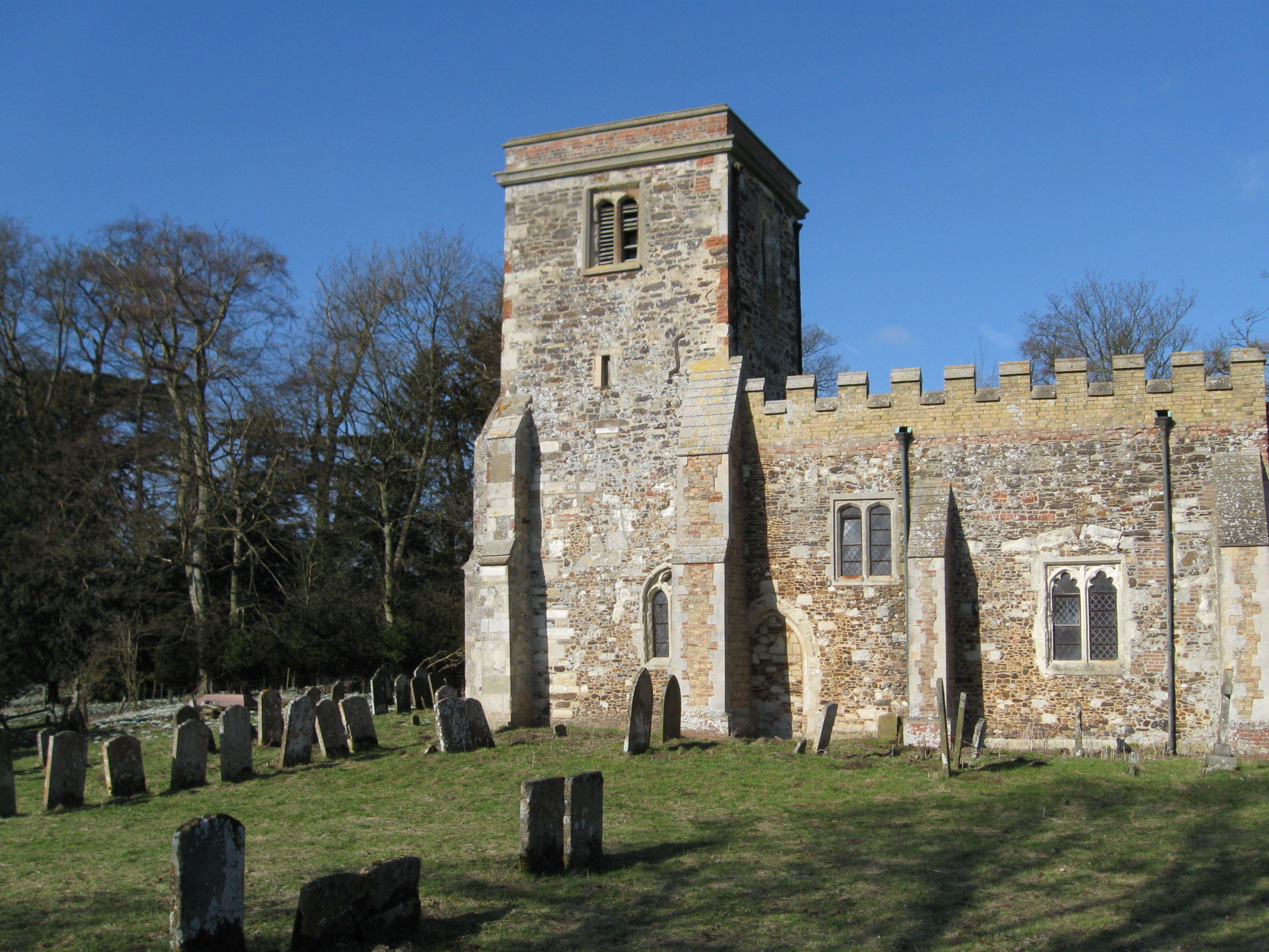
Church of St Peter, Milton Bryan

Church of St Peter is a Grade I listed church in Milton Bryan, Bedfordshire, England. It became a listed building on 23 January 1961. == History == St...

Battlesden

Battlesden is a hamlet and civil parish in the Central Bedfordshire district of Bedfordshire, England. It is just north of the A5, between Dunstable...

Toddington Manor, Bedfordshire

Toddington Manor is a Tudor country house in the English county of Bedfordshire, near the village of Toddington and is a Grade II listed building with...

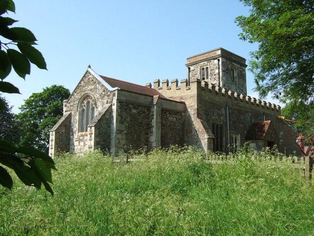
Church of St Peter & All Saints, Battlesden

Church of St Peter & All Saints is a Grade I listed church in Battlesden, Bedfordshire, England. It became a listed building on 23 January 1961. ��2...

Woburn Abbey

Woburn Abbey (), occupying the east of the village of Woburn, Bedfordshire, England, is a country house, the family seat of the Duke of Bedford. Although...

St Mary's Church, Potsgrove

St Mary's Church is a redundant Anglican church in the village of Potsgrove, Bedfordshire. England. It is recorded in the National Heritage List for England...

Nearby Amenities

Located within 500m of 51.960829,-0.57375803
Place: farm
Lat/Long: 51.9590741/-0.5800574
Barrier: kissing_gate
Lat/Long: 51.9585905/-0.5724084
Barrier: kissing_gate
Lat/Long: 51.9583911/-0.5701256
The data included in this document is from www.openstreetmap.org. The data is made available under ODbL.

Have you been to Greatfield Spinney?

Leave your review of Greatfield Spinney below (or comments, questions and feedback).