Sheepwalk Spinney
Wood, Forest in Northamptonshire
England
Sheepwalk Spinney

Sheepwalk Spinney is a charming woodland located in Northamptonshire, England. Situated near the village of Wood, this forested area covers approximately 10 acres and offers a tranquil escape from the bustling city life.
The woodland is predominantly composed of native tree species, including oak, beech, and ash, which create a dense canopy, providing shade and shelter for the diverse range of wildlife that call Sheepwalk Spinney their home. The forest floor is carpeted with a lush undergrowth of ferns, bluebells, and wildflowers, adding to the area's natural beauty.
Walking through Sheepwalk Spinney, visitors can enjoy a network of well-maintained footpaths that wind their way through the trees, offering peaceful and scenic routes for exploration. The paths are suitable for all levels of walkers and provide an opportunity to observe the abundant wildlife that resides in the area, such as deer, rabbits, and various species of birds.
The serene ambiance of Sheepwalk Spinney makes it an ideal spot for nature enthusiasts, bird watchers, and families looking to spend a day outdoors. There are picnic areas scattered throughout the woodland, allowing visitors to relax and enjoy a meal surrounded by the sounds of nature.
The forest is open to the public year-round and is managed by local authorities to ensure the preservation of its natural habitat. Access to Sheepwalk Spinney is free, and there is ample parking available nearby, making it easily accessible for both locals and tourists alike.
Overall, Sheepwalk Spinney in Northamptonshire offers a peaceful retreat where visitors can immerse themselves in the beauty of nature and enjoy a tranquil woodland experience.
If you have any feedback on the listing, please let us know in the comments section below.
Sheepwalk Spinney Images
Images are sourced within 2km of 52.485959/-0.56475725 or Grid Reference SP9788. Thanks to Geograph Open Source API. All images are credited.


Sheepwalk Spinney is located at Grid Ref: SP9788 (Lat: 52.485959, Lng: -0.56475725)
Unitary Authority: North Northamptonshire
Police Authority: Northamptonshire
What 3 Words
///really.blogs.sheds. Near Brigstock, Northamptonshire
Nearby Locations
Related Wikis

Banhaw, Spring and Blackthorn's Woods
Banhaw, Spring and Blackthorn's Woods is a 123.4-hectare (305-acre) biological Site of Special Scientific Interest east of Corby in Northamptonshire.These...

Upper Benefield
Upper Benefield is a linear village along the A427 road in the North Northamptonshire district of Northamptonshire, England. It is part of the civil parish...
Benefield
Benefield is a civil parish in North Northamptonshire, England, along the A427 road and about 6 miles (9.7 km) east of Corby and 3 miles (4.8 km) west...
Benefield Castle
Benefield Castle was sited in the village of Lower Benefield, between the towns of Corby and Oundle in Northamptonshire at grid reference SP987884. �...
Lower Benefield
Lower Benefield is a village on the A427 road in North Northamptonshire, England, near Oundle. It is part of the civil parish of Benefield. The villages...
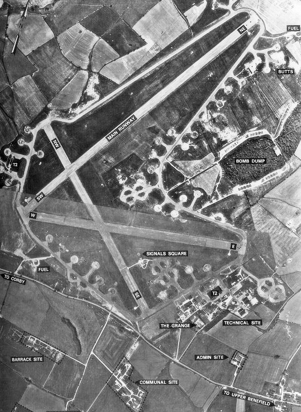
RAF Deenethorpe
Royal Air Force Deenethorpe or more simply RAF Deenethorpe is a former Royal Air Force station located 2 miles (3.2 km) east of Corby, Northamptonshire...

Corby (UK Parliament constituency)
Corby is a constituency in Northamptonshire represented in the House of Commons of the UK Parliament since May 2015 by Tom Pursglove of the Conservative...
Deenethorpe
Deenethorpe is a village and civil parish in North Northamptonshire, England. It is situated north-east of Corby and near the A43 road between Corby and...
Nearby Amenities
Located within 500m of 52.485959,-0.56475725Have you been to Sheepwalk Spinney?
Leave your review of Sheepwalk Spinney below (or comments, questions and feedback).