Ashton

Settlement in Herefordshire

England

Ashton

Main Ditch The land north of Leominster was once marshy and prone to flooding. The clue, other than memories of floods, is the name Eye, which suggests an island. There is a network of drains which feed this watercourse, The Main Ditch.
Main Ditch Credit: Richard Webb

Ashton is a small village located in the county of Herefordshire, in the West Midlands region of England. Situated in the stunning countryside, Ashton is surrounded by picturesque landscapes and rolling hills, making it an ideal destination for those seeking a peaceful and tranquil environment.

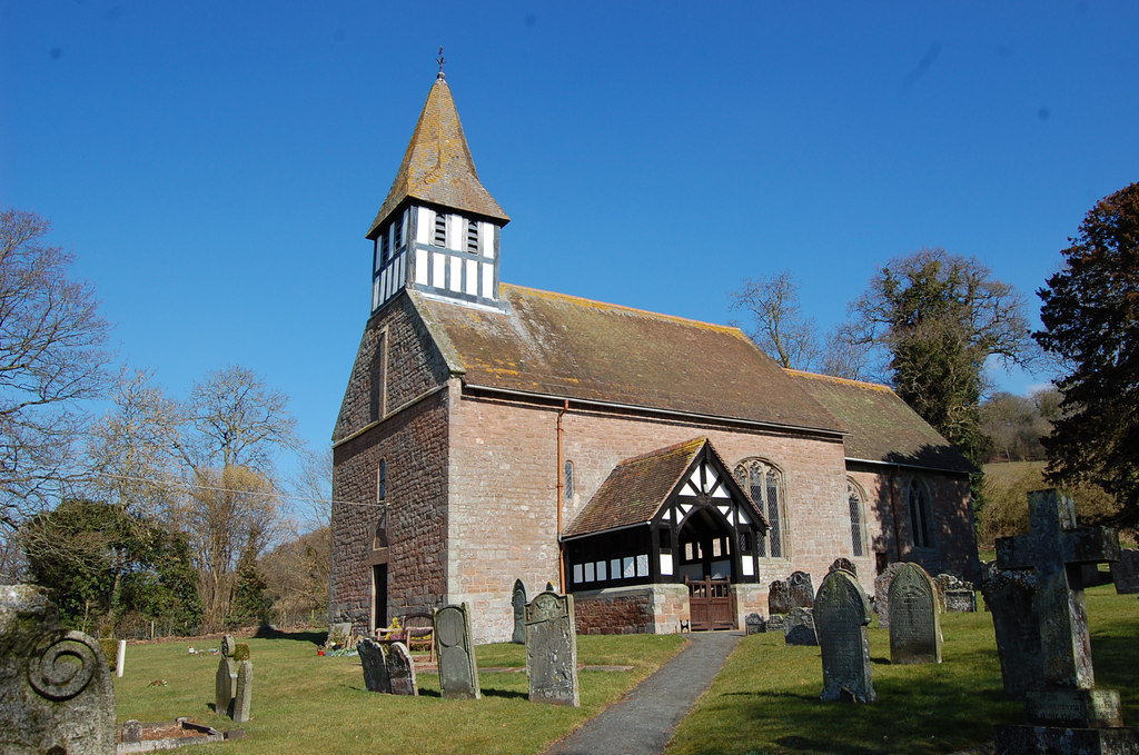
The village itself is characterized by its charming rural atmosphere and traditional architecture. It features a collection of quaint stone cottages, a beautiful parish church, and a village green that serves as a focal point for community gatherings and events.

Despite its small size, Ashton offers a range of amenities and services to its residents and visitors. There is a local pub, known for its warm hospitality and serving traditional British cuisine, as well as a village shop where essential groceries and daily necessities can be found.

Nature enthusiasts will find themselves in paradise here, with numerous walking trails and footpaths meandering through the surrounding countryside. The area is renowned for its natural beauty, with lush green fields, meadows, and woodlands providing the perfect backdrop for outdoor activities such as hiking, cycling, and bird-watching.

For those interested in history and culture, Ashton is within close proximity to several notable landmarks and attractions. The historic market town of Leominster is just a short drive away, offering a range of shops, restaurants, and historical sites to explore.

Overall, Ashton, Herefordshire, is a charming village that encapsulates the beauty and tranquility of the English countryside. Its idyllic setting, welcoming community, and abundance of natural wonders make it a truly delightful place to visit or call home.

If you have any feedback on the listing, please let us know in the comments section below.

Ashton Images

Images are sourced within 2km of 52.275937/-2.7127584 or Grid Reference SO5164. Thanks to Geograph Open Source API. All images are credited.

Main Ditch The land north of Leominster was once marshy and prone to flooding. The clue, other than memories of floods, is the name Eye, which suggests an island. There is a network of drains which feed this watercourse, The Main Ditch.
Main Ditch
The land north of Leominster was once marshy and prone to flooding. The clue, other than memories of floods, is the name Eye, which suggests an island. There is a network of drains which feed this watercourse, The Main Ditch.
Bridge over the Main Drain Road to Eye.
Bridge over the Main Drain
Road to Eye.
Berrington Hall from the courtyard This is the rear elevation of Berrington Hall taken from the courtyard. The Neo-Classical English country house designed for Thomas Harley by Henry Holland in the late 1770's. Today, under the management of the National Trust, it is such a great day out. Highly recommended.
Berrington Hall from the courtyard
This is the rear elevation of Berrington Hall taken from the courtyard. The Neo-Classical English country house designed for Thomas Harley by Henry Holland in the late 1770's. Today, under the management of the National Trust, it is such a great day out. Highly recommended.
The stable block, Berrington Court from the courtyard A most elegant and pleasing stable block. Understated, functional but impressive and in accordance with Neo-Classical principles. Imagine owning it and the quality horses or coaches and carriages it no doubt once housed.
The stable block, Berrington Court from the courtyard
A most elegant and pleasing stable block. Understated, functional but impressive and in accordance with Neo-Classical principles. Imagine owning it and the quality horses or coaches and carriages it no doubt once housed.
Berrington Hall, near Leominster The front elevation from the edge of the ha-ha. Managed by the National Trust the house has superb interiors, ceilings, furniture, paintings, servant's quarters and an interesting history under several families.
Berrington Hall, near Leominster
The front elevation from the edge of the ha-ha. Managed by the National Trust the house has superb interiors, ceilings, furniture, paintings, servant's quarters and an interesting history under several families.
Berrington Hall, near Leominster National Trust managed with superb rooms and informative volunteer guides. The story of the house and its successive resident families the Harleys', the Digbys' and the Cawdors between the 1780s and the 1950's is riveting and compelling. Then there is the gardens, the grounds, the lake, the views. Or the shop, the tea room and various events throughout the year.
Berrington Hall, near Leominster
National Trust managed with superb rooms and informative volunteer guides. The story of the house and its successive resident families the Harleys', the Digbys' and the Cawdors between the 1780s and the 1950's is riveting and compelling. Then there is the gardens, the grounds, the lake, the views. Or the shop, the tea room and various events throughout the year.
Scene at Berrington Hall, near Leominster Some people will do anything to avoid the guided tours.
Scene at Berrington Hall, near Leominster
Some people will do anything to avoid the guided tours.
The rear of the stable block at Berrington Hall near Leominster Now looking its age. It is around 230 years old.
The rear of the stable block at Berrington Hall near Leominster
Now looking its age. It is around 230 years old.
The garden lodge at Berrington Hall The public enter Berrington Hall from a car park on the far side of the garden lodge, then walk up this path towards the hall. Off to the left are the walled gardens.
The garden lodge at Berrington Hall
The public enter Berrington Hall from a car park on the far side of the garden lodge, then walk up this path towards the hall. Off to the left are the walled gardens.
Part of the walled garden at Berrington Hall in July OK it's a bit Highgrove but an interesting garden, very English and lovely to amble through on a July afternoon in between rain showers and bursts of sunshine.
Part of the walled garden at Berrington Hall in July
OK it's a bit Highgrove but an interesting garden, very English and lovely to amble through on a July afternoon in between rain showers and bursts of sunshine.
Part of the walled vegetable garden at Berrington Hall The vegetable gardens here are quite extensive. The volunteers who work in the gardens enable the National Trust to sell the produce to the public and to use the veg in the menu for the tea room.
Part of the walled vegetable garden at Berrington Hall
The vegetable gardens here are quite extensive. The volunteers who work in the gardens enable the National Trust to sell the produce to the public and to use the veg in the menu for the tea room.
Part of the walled vegetable garden at Berrington Hall The scarecrow keeps the birds away apparently. The sunflowers here must be attractive to finches soon so I hope they aren't put off too much.
Part of the walled vegetable garden at Berrington Hall
The scarecrow keeps the birds away apparently. The sunflowers here must be attractive to finches soon so I hope they aren't put off too much.
Poplars and mistletoe A line of poplars has been planted along this field boundary on the hill top. Mistletoe is growing on several trees.
Poplars and mistletoe
A line of poplars has been planted along this field boundary on the hill top. Mistletoe is growing on several trees.
Blackcurrant field A commercial plantation of blackcurrants. The Clee Hills are in the distance.
Blackcurrant field
A commercial plantation of blackcurrants. The Clee Hills are in the distance.
Goat herd
Goat herd
Tradesman's Entrance The rear entrance to Berrington Hall
Tradesman's Entrance
The rear entrance to Berrington Hall
A good old fashioned (working!) phone box! Yes - it DID work, but not with cash!!!!!!
Near the entrance to Berrington Hall, nr Leominster
A good old fashioned (working!) phone box!
Yes - it DID work, but not with cash!!!!!! Near the entrance to Berrington Hall, nr Leominster
A49 near Ratefield Farm
Show me another place!

Ashton is located at Grid Ref: SO5164 (Lat: 52.275937, Lng: -2.7127584)

Unitary Authority: County of Herefordshire

Police Authority: West Mercia

What 3 Words

///essays.expensive.stumpy. Near Kimbolton, Herefordshire

Related Wikis

Ashton, Herefordshire

Ashton is a village in the Eye, Moreton and Ashton civil parish of Herefordshire, England, and is 3 miles (5 km) north from Leominster, 15 miles (24 km...

Berrington Hall

Berrington Hall is a country house located about 3 miles (5 km) north of Leominster, Herefordshire, England. During the 20th century it was the seat of...

Eye, Moreton and Ashton

Eye, Moreton and Ashton is a civil parish in the county of Herefordshire, England. The parish is 15 miles (24 km) north from the city and county town of...

Castle Frome

Castle Frome is a village and civil parish in the county of Herefordshire, England, and is 10 miles (16 km) north-east from the city and county town of...

Nearby Amenities

Located within 500m of 52.275937,-2.7127584
Moreton Turn
Local Ref: NK
Naptan AtcoCode: 2090A133100
Naptan Bearing: E
Naptan BusStopType: CUS
Naptan CommonName: Moreton Turn
Naptan Indicator: NK
Naptan Landmark: Junction with A49
Naptan NaptanCode: heragagd
Naptan Street: Eye Lane
Naptan Verified: no
Source: naptan_import
Lat/Long: 52.2760434/-2.7125465
Hundred Turn
Naptan AtcoCode: 2090A133102
Naptan Bearing: N
Naptan BusStopType: CUS
Naptan CommonName: Hundred Turn
Naptan Indicator: opp
Naptan Landmark: N/K
Naptan NaptanCode: heragagj
Naptan Street: A49
Naptan Verified: no
Source: naptan_import
Lat/Long: 52.2725771/-2.7102658
Hundred Turn
Naptan AtcoCode: 2090A18851
Naptan Bearing: S
Naptan BusStopType: CUS
Naptan CommonName: Hundred Turn
Naptan Indicator: adj
Naptan Landmark: N/K
Naptan NaptanCode: herajgda
Naptan Street: A49
Naptan Verified: no
Source: naptan_import
Lat/Long: 52.2725784/-2.7101606
Moreton Turn
Naptan AtcoCode: 2090A20323
Naptan Bearing: W
Naptan BusStopType: CUS
Naptan CommonName: Moreton Turn
Naptan Indicator: adj junction with A49
Naptan Landmark: Junction
Naptan NaptanCode: herapdwt
Naptan Street: Eye Lane
Naptan Verified: no
Source: naptan_import
Lat/Long: 52.2759718/-2.7124867
Ashton
Place: hamlet
Wikidata: Q4805973
Lat/Long: 52.2754574/-2.7113477
The data included in this document is from www.openstreetmap.org. The data is made available under ODbL.

Have you been to Ashton?

Leave your review of Ashton below (or comments, questions and feedback).