Halton Wood

Wood, Forest in Buckinghamshire

England

Halton Wood

Field north of Wendover Woods Wendover Woods has the highest point of the Chiltern Hills which is also the 'county top' of Buckinghamshire. A stone in the woods marks what is considered to be the highest point, though it's not marked on OS maps. This field lies to the east of the stone; the view is to the west and the trees of Tatnall's Wood.
Field north of Wendover Woods Credit: Trevor Littlewood

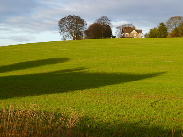
Halton Wood is a picturesque woodland located in the county of Buckinghamshire, England. Situated near the village of Halton, this woodland is renowned for its natural beauty and diverse ecosystem. Covering an area of approximately 100 hectares, Halton Wood is a popular destination for nature enthusiasts, hikers, and wildlife observers.

The wood is characterized by a mixture of deciduous and coniferous trees, creating a rich tapestry of colors throughout the seasons. Oak, beech, birch, and pine trees dominate the landscape, providing a habitat for a wide range of flora and fauna. Bluebells carpet the forest floor in spring, creating a stunning display of vibrant blue hues.

Walking trails wind their way through the wood, allowing visitors to explore its hidden treasures. The paths are well-maintained and marked, making it easy for visitors to navigate and enjoy the woodland at their own pace. Along the way, one may encounter squirrels, foxes, badgers, and a variety of bird species, including woodpeckers and owls.

Halton Wood offers a peaceful and tranquil environment, providing an escape from the hustle and bustle of everyday life. It is a perfect destination for those seeking solitude and a connection with nature. The wood also serves as an important conservation area, protecting the local biodiversity and providing a valuable habitat for wildlife.

Overall, Halton Wood in Buckinghamshire is a natural gem that showcases the beauty and diversity of the English countryside. Its stunning scenery, well-maintained trails, and abundant wildlife make it a must-visit location for nature lovers and outdoor enthusiasts.

If you have any feedback on the listing, please let us know in the comments section below.
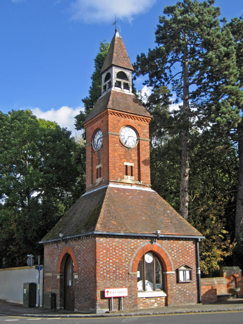
Halton Wood Images

Images are sourced within 2km of 51.76961/-0.71450302 or Grid Reference SP8808. Thanks to Geograph Open Source API. All images are credited.

Field north of Wendover Woods Wendover Woods has the highest point of the Chiltern Hills which is also the 'county top' of Buckinghamshire. A stone in the woods marks what is considered to be the highest point, though it's not marked on OS maps. This field lies to the east of the stone; the view is to the west and the trees of Tatnall's Wood.
Field north of Wendover Woods
Wendover Woods has the highest point of the Chiltern Hills which is also the 'county top' of Buckinghamshire. A stone in the woods marks what is considered to be the highest point, though it's not marked on OS maps. This field lies to the east of the stone; the view is to the west and the trees of Tatnall's Wood.
Chickweed Growing on the uncultivated fringe of a field.
Chickweed
Growing on the uncultivated fringe of a field.
Field corner with cow parsley and hawthorn A fenced off fringe of a pasture - actually just off the public footpath.
Field corner with cow parsley and hawthorn
A fenced off fringe of a pasture - actually just off the public footpath.
The Red House, Aylesbury Road The house dates from the early C18.
The Red House, Aylesbury Road
The house dates from the early C18.
Bank Farm House, Tring Road, Wendover
Clock tower, Wendover Built in 1842 the clock tower now serves as a Tourist Information Office.
Clock tower, Wendover
Built in 1842 the clock tower now serves as a Tourist Information Office.
Farmland, Wendover A house on Hale Lane viewed from the Ridgeway on Hogtrough Lane.
Farmland, Wendover
A house on Hale Lane viewed from the Ridgeway on Hogtrough Lane.
Footpath,  Wendover Woods Numerous paths straggle across the Forestry Commission woodlands of Wendover Woods, this is a view along one of them as it leaves the access road.
The tarmacked access road through the woods allows vehicular access to the various facilities such as car parks, barbecue areas, café and "Go Ape" - as well as the many woodland walks.
Footpath, Wendover Woods
Numerous paths straggle across the Forestry Commission woodlands of Wendover Woods, this is a view along one of them as it leaves the access road. The tarmacked access road through the woods allows vehicular access to the various facilities such as car parks, barbecue areas, café and "Go Ape" - as well as the many woodland walks.
Glade in Wendover Woods Taken from the footpath seen in <a href="https://www.geograph.org.uk/photo/2958760">SP8809 : Footpath,  Wendover Woods</a> looking into a glade of mostly deciduous trees, though the tree in the foreground is a yew, which is an evergreen, though not a conifer.
Glade in Wendover Woods
Taken from the footpath seen in SP8809 : Footpath, Wendover Woods looking into a glade of mostly deciduous trees, though the tree in the foreground is a yew, which is an evergreen, though not a conifer.
Hale Road, Wendover The edge of town. Houses down one side, fields on the other.
Hale Road, Wendover
The edge of town. Houses down one side, fields on the other.
Towards Boddington Hill View from the Icknield Way path, I think.
Wendover is criss crossed by so many paths it's hard to figure out which one you're on sometimes.
Towards Boddington Hill
View from the Icknield Way path, I think. Wendover is criss crossed by so many paths it's hard to figure out which one you're on sometimes.
Crossroads at Hale Wood
Wendover Woods, view south-west
Wendover view from Haddington Hill Coombe Hill can be seen beyond the Buckinghamshire town of Wendover from one of the higher points of the county in the Wendover Woods.  At this time of year, when trees are in leaf, views like this are far and few between in these parts.
Wendover view from Haddington Hill
Coombe Hill can be seen beyond the Buckinghamshire town of Wendover from one of the higher points of the county in the Wendover Woods. At this time of year, when trees are in leaf, views like this are far and few between in these parts.
Glimpse of Boddington Hill from Haddington Hill Green is the colour - Wendover Woods in summer.
Glimpse of Boddington Hill from Haddington Hill
Green is the colour - Wendover Woods in summer.
Boddington Hill from Hale Lane, south-east of Wendover
Chivery Cottage from Black Wood This good looking house with unusual full height windows fitted between the old beams of the rear gables is I believe called Chivery Cottage. The view is from the path from The Crong to Chivery just as it has emerged from Black Wood.
Chivery Cottage from Black Wood
This good looking house with unusual full height windows fitted between the old beams of the rear gables is I believe called Chivery Cottage. The view is from the path from The Crong to Chivery just as it has emerged from Black Wood.
Wendover Clock Tower Started in 1842 as a market hall, the clock and bell were added much later. It became a garage for the village's fire engine and a prisoner cell.  Currently, it is used by the tourist office (wendoverclocktower.org.uk).
Wendover Clock Tower
Started in 1842 as a market hall, the clock and bell were added much later. It became a garage for the village's fire engine and a prisoner cell. Currently, it is used by the tourist office (wendoverclocktower.org.uk).
Show me another place!

Halton Wood is located at Grid Ref: SP8808 (Lat: 51.76961, Lng: -0.71450302)

Unitary Authority: Buckinghamshire

Police Authority: Thames Valley

What 3 Words

///fixtures.trail.headings. Near Wendover, Buckinghamshire

Related Wikis

Wendover Woods

Wendover Woods is an area of woodland on the north edge of the Chiltern Hills in England. Named after the nearby town of Wendover, the woods are part of...

Haddington Hill

Haddington Hill (also called Wendover Hill) is a hill in The Chilterns, and the highest point in the English county of Buckinghamshire. On the north-eastern...

Boddington Camp

Boddington Camp is an Iron Age hillfort, about 1 mile east of Wendover in Buckinghamshire, England. It is a scheduled monument. == Description == The fort...

Trenchard Museum

The Trenchard Museum is based at RAF Halton, Halton, Buckinghamshire, England. The overall aim of the museum is to preserve and display items that relate...

Nearby Amenities

Located within 500m of 51.76961,-0.71450302
Tourism: viewpoint
Lat/Long: 51.7717358/-0.7184547
Go Ape!
Addr City: Aylesbury
Addr Postcode: HP22 5NF
Addr Street: St Leonards Road
Addr Town: Wendover
Brand: Go Ape
Brand Website: https://goape.co.uk/
Brand Wikidata: Q5574692
Brand Wikipedia: en:Go Ape
Leisure: high_ropes_course
Tourism: attraction
Website: https://goape.co.uk/locations/wendover
Lat/Long: 51.771602/-0.7136308
Wendover Woods
Description: Highest Point of the Chiltern Hills
Ele: 267.5
Natural: peak
Source: https://www.hill-bagging.co.uk/mountaindetails.php?qu=S&rf=2874
Tourism: minor_attraction
Wikidata: Q5637668
Wikipedia: en:Haddington Hill
Lat/Long: 51.7723763/-0.7111233
Bench
Source: Bing
Lat/Long: 51.7716148/-0.7183214
Bicycle Parking
Bicycle Parking: stands
Capacity: 6
Source: survey
Lat/Long: 51.7723051/-0.7132327
Bench
Source: survey
Lat/Long: 51.7684429/-0.7101044
Bench
Backrest: yes
Lat/Long: 51.7726355/-0.7122197
Waste Basket
Check Date: 2021-08-22
Waste: dog_excrement
Lat/Long: 51.7716409/-0.7148704
Bbq
Check Date: 2021-08-22
Lat/Long: 51.770112/-0.7162035
Bbq
Lat/Long: 51.7706301/-0.7157228
Bbq
Check Date: 2021-08-22
Lat/Long: 51.7696226/-0.7165809
Check Date: 2021-08-22
Covered: no
Leisure: picnic_table
Lat/Long: 51.7696265/-0.7165142
Bbq
Check Date: 2021-08-22
Lat/Long: 51.7698339/-0.7166563
Check Date: 2021-08-22
Covered: no
Leisure: picnic_table
Lat/Long: 51.7698356/-0.7165253
Check Date: 2021-08-22
Covered: no
Leisure: picnic_table
Lat/Long: 51.7701521/-0.7161517
Bench
Backrest: no
Lat/Long: 51.7706825/-0.7157849
Check Date: 2021-08-22
Covered: no
Leisure: picnic_table
Lat/Long: 51.7706388/-0.7161227
Bbq
Check Date: 2021-08-22
Lat/Long: 51.7705978/-0.7160335
Check Date: 2021-08-22
Covered: no
Leisure: picnic_table
Lat/Long: 51.7704169/-0.7160479
Waste Basket
Waste: dog_excrement
Lat/Long: 51.768952/-0.7166581
Bench
Backrest: yes
Check Date: 2021-08-22
Lat/Long: 51.7678349/-0.7179388
Bench
Backrest: no
Check Date: 2021-08-22
Lat/Long: 51.7670996/-0.7182366
Traffic Calming: bump
Lat/Long: 51.7731201/-0.713223
Waste Basket
Waste: trash
Lat/Long: 51.7724052/-0.7128557
Recycling
Recycling Type: container
Lat/Long: 51.7724018/-0.7128711
Entrance: yes
Lat/Long: 51.7723123/-0.71277
Entrance: main
Lat/Long: 51.77241/-0.7128251
Leisure: pitch
Sport: table_tennis
Lat/Long: 51.7722068/-0.7134005
Highway Rat Activity Trail - Start
Board Type: nature
Information: board
Tourism: information
Website: https://www.forestry.gov.uk/forestry/INFD-9HXEGU
Lat/Long: 51.7700944/-0.7152137
Mischievous animals
Board Type: nature
Information: board
Note: Part of the Highway Rat Activity Trail - Board 1
Tourism: information
Website: https://www.forestry.gov.uk/forestry/INFD-9HXEGU
Lat/Long: 51.7697927/-0.7155852
Hop to it!
Board Type: nature
Information: board
Note: Part of the Highway Rat Activity Trail - Board 2
Tourism: information
Website: https://www.forestry.gov.uk/forestry/INFD-9HXEGU
Lat/Long: 51.7692308/-0.7160378
Nuts and seeds
Board Type: nature
Information: board
Note: Part of the Highway Rat Activity Trail - Board 3
Tourism: information
Website: https://www.forestry.gov.uk/forestry/INFD-9HXEGU
Lat/Long: 51.7685022/-0.7165511
Mini but mighty
Board Type: nature
Information: board
Note: Part of the Highway Rat Activity Trail - Board 4
Tourism: information
Website: https://www.forestry.gov.uk/forestry/INFD-9HXEGU
Lat/Long: 51.7679577/-0.7172663
Creepy Crawlies
Board Type: nature
Information: board
Note: Part of the Highway Rat Activity Trail - Board 5
Tourism: information
Website: https://www.forestry.gov.uk/forestry/INFD-9HXEGU
Lat/Long: 51.7674469/-0.7178242
Bench
Backrest: yes
Lat/Long: 51.7668937/-0.718602
Bench
Backrest: no
Lat/Long: 51.7675536/-0.7142025
Bench
Backrest: no
Lat/Long: 51.7701334/-0.7124571
Bench
Backrest: yes
Check Date: 2023-06-10
Lat/Long: 51.7713272/-0.7120796
Bench
Backrest: yes
Check Date: 2023-06-10
Lat/Long: 51.7714566/-0.7120702
Welcome to Wendover Woods
Bicycle: yes
Hiking: yes
Horse: yes
Information: map
Map Size: site
Map Type: scheme
Tourism: information
Lat/Long: 51.772117/-0.7135323
Wendover Woods Transformation
Board Type: notice
Description: Information about the building work
Information: board
Tourism: information
Lat/Long: 51.7722566/-0.7132973
Bench
Backrest: no
Lat/Long: 51.7717936/-0.7118724
Bench
Backrest: no
Lat/Long: 51.7717803/-0.7118985
Bench
Backrest: no
Lat/Long: 51.7717948/-0.7118388
Orienteering Course Start
Information: board
Orienteering: start
Sport: orienteering
Tourism: information
Website: https://www.forestry.gov.uk/forestry/englandbuckinghamshirenoforestwendoverwoodsmainentranceorienteeringcourse
Lat/Long: 51.7717721/-0.7118534
Bench
Backrest: yes
Check Date: 2021-08-22
Lat/Long: 51.7712923/-0.7117711
Bench
Backrest: yes
Lat/Long: 51.771306/-0.7116035
Bench
Backrest: yes
Lat/Long: 51.7710002/-0.7117429
Gruffalo Statue
Description: ~6 foot high, carved from wood
Historic: memorial
Memorial: statue
Lat/Long: 51.771016/-0.7115552
Waste Basket
Waste: dog_excrement
Lat/Long: 51.7715126/-0.7115082
Bench
Backrest: yes
Check Date: 2021-08-22
Lat/Long: 51.7714778/-0.7114875
Bench
Backrest: yes
Check Date: 2021-08-22
Lat/Long: 51.7719419/-0.7097511
Traffic Calming: bump
Lat/Long: 51.7724922/-0.7113095
Leisure: picnic_table
Lat/Long: 51.7727338/-0.7112159
Leisure: picnic_table
Lat/Long: 51.7728367/-0.7111824
Leisure: picnic_table
Lat/Long: 51.7730325/-0.711932
Check Date: 2021-08-22
Leisure: picnic_table
Lat/Long: 51.773664/-0.7118556
Check Date: 2021-08-22
Leisure: picnic_table
Lat/Long: 51.7736715/-0.7120031
Leisure: picnic_table
Lat/Long: 51.7731396/-0.7117671
Countryside Award 1970
Historic: memorial
Memorial: plaque
Lat/Long: 51.7727354/-0.712608
Beneath your feet
Board Type: geology
Information: board
Tourism: information
Lat/Long: 51.7725836/-0.7127514
Vending Machine
Vending: parking_tickets
Lat/Long: 51.7725375/-0.7130096
Explore Wendover Woods
Bicycle: yes
Hiking: yes
Horse: yes
Information: map
Map Size: site
Map Type: scheme
Tourism: information
Lat/Long: 51.772501/-0.713127
Welcome to Wendover Woods
Bicycle: yes
Check Date: 2022-11-02
Hiking: yes
Horse: yes
Information: map
Map Size: site
Map Type: scheme
Tourism: information
Lat/Long: 51.7704064/-0.7156975
Barbecues at Wendover Woods
Board Type: notice
Check Date: 2022-11-02
Information: board
Tourism: information
Lat/Long: 51.7704056/-0.7156932
Brilliant Birds
Board Type: nature
Information: board
Note: Part of the Highway Rat Activity Trail - Board 6
Tourism: information
Website: https://www.forestry.gov.uk/forestry/INFD-9HXEGU
Lat/Long: 51.7673212/-0.7190607
Bench
Backrest: no
Check Date: 2021-08-22
Lat/Long: 51.7669983/-0.7194154
Bench
Backrest: yes
Lat/Long: 51.7673983/-0.7177512
Woodland stepping logs
Playground: climbingframe
Lat/Long: 51.7696633/-0.7155693
Wendover Woods hollow fort
Playground: climbingframe
Lat/Long: 51.7678291/-0.7172793
Material: wood
Power: pole
Lat/Long: 51.771928/-0.7090312
Toilets
Access: yes
Changing Table: yes
Fee: no
Wheelchair: yes
Lat/Long: 51.7720217/-0.7124212
Cafe
Wendover Woods Cafe
Addr City: Wendover
Addr Postcode: HP22 5NF
Addr Street: St Leonards Road
Indoor Seating: yes
Internet Access: wlan
Outdoor Seating: yes
Website: https://www.wendoverwoodscafe.co.uk/
Lat/Long: 51.7719191/-0.7127326
Barrier: lift_gate
Lat/Long: 51.7735073/-0.7133099
The data included in this document is from www.openstreetmap.org. The data is made available under ODbL.

Have you been to Halton Wood?

Leave your review of Halton Wood below (or comments, questions and feedback).