Skippingdale Plantation

Wood, Forest in Lincolnshire

England

Skippingdale Plantation

A1077 Mannaberg Way
A1077 Mannaberg Way Credit: Colin Pyle

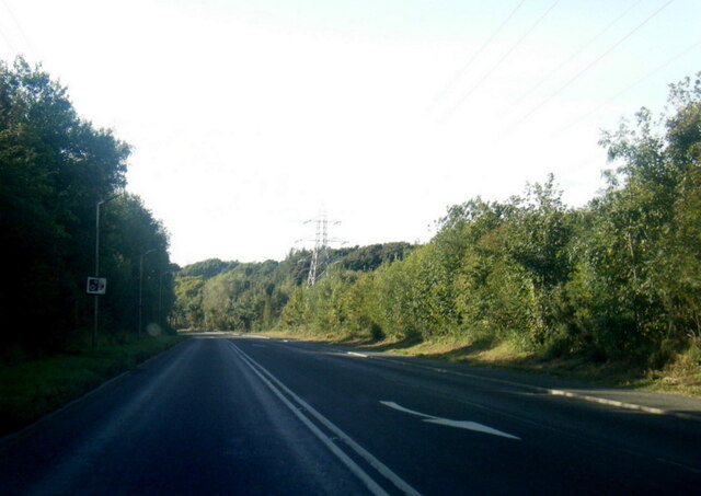
Skippingdale Plantation is a woodland area located in Lincolnshire, England. It covers an extensive area and is known for its diverse range of trees and wildlife. The plantation is situated near the town of Scunthorpe, making it easily accessible for visitors and locals alike.

The woodland consists mainly of broadleaf trees, including oak, beech, and birch, which provide a beautiful canopy of foliage throughout the year. These trees create a peaceful and serene environment, making the plantation a popular destination for nature lovers and outdoor enthusiasts.

Walking trails wind their way through the plantation, allowing visitors to explore the area and take in the stunning scenery. These trails are well-maintained, offering a comfortable and enjoyable walking experience. Along the paths, visitors may come across various species of wildlife, such as deer, rabbits, and a variety of bird species.

Skippingdale Plantation also serves as an important habitat for many rare and endangered plant species. The diverse ecosystem found here supports a wide range of flora and fauna, contributing to the overall biodiversity of the region.

The plantation is managed by local authorities, who ensure the preservation and conservation of the woodland. This includes regular tree maintenance, clearing of invasive species, and monitoring of wildlife populations.

Overall, Skippingdale Plantation is a picturesque woodland area that offers a tranquil escape from the hustle and bustle of everyday life. Its natural beauty, well-maintained trails, and diverse wildlife make it a popular destination for nature enthusiasts and a valuable asset to the local community.

If you have any feedback on the listing, please let us know in the comments section below.

Skippingdale Plantation Images

Images are sourced within 2km of 53.604291/-0.67147133 or Grid Reference SE8812. Thanks to Geograph Open Source API. All images are credited.

A1077 Mannaberg Way
A1077 Mannaberg Way
A1077 near Foxhills Plantation
A1077 Phoenix Way by power lines
Waste iron slag boulders on disused steel works site Scunthorpe The Trent Valley Way although undefined passes through this area where there are a number of waste slag boulders. There are a plethora of paths in the area over this former steel works site.
Waste iron slag boulders on disused steel works site Scunthorpe
The Trent Valley Way although undefined passes through this area where there are a number of waste slag boulders. There are a plethora of paths in the area over this former steel works site.
Wetherspoons Pub - Scunthorpe The Blue Bell Inn, Oswald Road. I am not sure if this is one of their pubs that is reusing an old building or a new owner for an existing pub. If anyone knows, I would be glad of a correction.
Wetherspoons Pub - Scunthorpe
The Blue Bell Inn, Oswald Road. I am not sure if this is one of their pubs that is reusing an old building or a new owner for an existing pub. If anyone knows, I would be glad of a correction.
Pakistan Social Cultural and Islamic Centre The first mosque visited by the Queen in this country. The occasion was her visit to Scunthorpe as part of her tour of Britain during her Golden Jubilee Year, 2002.
Pakistan Social Cultural and Islamic Centre
The first mosque visited by the Queen in this country. The occasion was her visit to Scunthorpe as part of her tour of Britain during her Golden Jubilee Year, 2002.
The beginning of the end of Gurnell Street Gurnell Street is an L shaped street, so has north, south, east and west sides. As part of the Advance Crosby scheme it is proposed to demolish all of it, though this may be phased over a number of years. Eventually new housing will be provided but as yet no developer has been found who will commit to this work. But the demolitions go on. Here the first part of Gurnell Street to go (the west side) has been flattened and the rubble is in process of being cleared. What was there before can just be seen on the extreme left of <a href="https://www.geograph.org.uk/photo/1916766">SE8911 : Scunthorpe Church of England Primary School</a>. The trees are in the now closed Scunthorpe Cemetery.
The beginning of the end of Gurnell Street
Gurnell Street is an L shaped street, so has north, south, east and west sides. As part of the Advance Crosby scheme it is proposed to demolish all of it, though this may be phased over a number of years. Eventually new housing will be provided but as yet no developer has been found who will commit to this work. But the demolitions go on. Here the first part of Gurnell Street to go (the west side) has been flattened and the rubble is in process of being cleared. What was there before can just be seen on the extreme left of SE8911 : Scunthorpe Church of England Primary School. The trees are in the now closed Scunthorpe Cemetery.
The Church of the Resurrection Dates from 1960.
The Church of the Resurrection
Dates from 1960.
Farm track This rural scene looked very different 40 years ago. On the hill on the right was the Normanby Park steelworks and associated slagheaps.
Farm track
This rural scene looked very different 40 years ago. On the hill on the right was the Normanby Park steelworks and associated slagheaps.
Neap House Farm The road in the foreground is part of the road which ran along the Trent bank between Flixborough and Gunness. This road has been replaced by a new one further east thus obviating traffic to Neap House Wharf having to negotiate a very tight bend at Neap House Farm.
Neap House Farm
The road in the foreground is part of the road which ran along the Trent bank between Flixborough and Gunness. This road has been replaced by a new one further east thus obviating traffic to Neap House Wharf having to negotiate a very tight bend at Neap House Farm.
Park Ings Store Extensively damaged in the Flixborough disaster of 1974 <span class="nowrap"><a title="http://en.wikipedia.org/wiki/Flixborough_disaster" rel="nofollow ugc noopener" href="http://en.wikipedia.org/wiki/Flixborough_disaster">Link</a><img style="margin-left:2px;" alt="External link" title="External link - shift click to open in new window" src="https://s1.geograph.org.uk/img/external.png" width="10" height="10"/></span>
Park Ings Store
Extensively damaged in the Flixborough disaster of 1974 LinkExternal link
The tenfoot behind Wells Street Tenfoot is the usual term used locally for the alleyways behind terraced houses.
The tenfoot behind Wells Street
Tenfoot is the usual term used locally for the alleyways behind terraced houses.
The tenfoot between Gurnell Street and Berkeley Street Crosby flats in the background.
The tenfoot between Gurnell Street and Berkeley Street
Crosby flats in the background.
The Ironstone Centre Scunthorpe's new medical facility. For a view of it under construction see <a href="https://www.geograph.org.uk/photo/2171869">SE8911 : New Health Centre under construction</a>. The different coloured window panels denote different zones within the building. Good for those with a good sense of direction; not much help to those who don't.
The Ironstone Centre
Scunthorpe's new medical facility. For a view of it under construction see SE8911 : New Health Centre under construction. The different coloured window panels denote different zones within the building. Good for those with a good sense of direction; not much help to those who don't.
The Ironstone Centre View of the main entrance from West Street.
The Ironstone Centre
View of the main entrance from West Street.
The tenfoot between Dale Street and Buckingham Street Detuyll Street crosses in the centre of the picture.
The tenfoot between Dale Street and Buckingham Street
Detuyll Street crosses in the centre of the picture.
Scunthorpe General Hospital - Church Lane I have never been inside so cannot comment about the facilities.
Scunthorpe General Hospital - Church Lane
I have never been inside so cannot comment about the facilities.
Ironstone cottage, Old Crosby Little remains of the village of Crosby which existed before the expansion of Scunthorpe in the late nineteenth century. This cottage just predates that expansion.
Ironstone cottage, Old Crosby
Little remains of the village of Crosby which existed before the expansion of Scunthorpe in the late nineteenth century. This cottage just predates that expansion.
Show me another place!

Skippingdale Plantation is located at Grid Ref: SE8812 (Lat: 53.604291, Lng: -0.67147133)

Unitary Authority: North Lincolnshire

Police Authority: Humberside

What 3 Words

///update.honest.soft. Near Scunthorpe, Lincolnshire

Related Wikis

Atkinsons Warren

Atkinsons Warren is a large area of woodland in northwest Scunthorpe, North Lincolnshire, England. It is a Local Nature Reserve, and includes a meadow...

Outwood Academy Foxhills

Outwood Academy Foxhills is a mixed secondary school located in Scunthorpe, North Lincolnshire, England. == History == === Secondary modern school === The...

Crosby, Lincolnshire

Crosby was a small hamlet in Lincolnshire which has grown into a suburb in the north of Scunthorpe, North Lincolnshire. Remnants of the old hamlet can...

North Lincolnshire

North Lincolnshire is a unitary authority area with borough status in Lincolnshire, England. At the 2011 Census, it had a population of 167,446. The administrative...

Nearby Amenities

Located within 500m of 53.604291,-0.67147133
Bus Stop
Foxhills Road
Naptan AtcoCode: 227000010576
Naptan Bearing: E
Naptan CommonName: Foxhills Road
Naptan Indicator: adj
Naptan NaptanCode: scudtdt
Naptan Street: Reginald Road
Naptan Verified: no
Source: naptan_import
Lat/Long: 53.6017208/-0.6671242
Bus Stop
Sorrell Way
Alt Name: Avenue Clamart
Naptan AltCommonName: Avenue Clamart
Naptan AltIndicator: opp
Naptan AltStreet: Luneburg Way
Naptan AtcoCode: 227000010750
Naptan Bearing: N
Naptan CommonName: Sorrell Way
Naptan Indicator: adj
Naptan NaptanCode: scugdgj
Naptan Street: Luneburg Way
Naptan Verified: no
Source: naptan_import
Lat/Long: 53.6039273/-0.6788434
Power: tower
Lat/Long: 53.6057035/-0.6785562
Power: tower
Lat/Long: 53.6060664/-0.6734707
Power: tower
Lat/Long: 53.60613/-0.6651666
Power: tower
Lat/Long: 53.6067666/-0.6688895
Power: tower
Lat/Long: 53.6056526/-0.6645336
Power: tower
Lat/Long: 53.6063783/-0.6740179
Power: tower
Lat/Long: 53.6064674/-0.6690934
Crossing
Button Operated: yes
Crossing: traffic_signals
Crossing Island: no
Crossing Markings: dots
Tactile Paving: yes
Lat/Long: 53.6062393/-0.6735697
Power: pole
Lat/Long: 53.6061131/-0.6682781
Power: pole
Lat/Long: 53.6067636/-0.6665256
Power: pole
Lat/Long: 53.6070072/-0.6681894
Power: pole
Lat/Long: 53.607238/-0.6689171
foxhill park
Name En: foxhill park
Tourism: picnic_site
Lat/Long: 53.6014627/-0.6711035
Generator Method: photovoltaic
Generator Output Electricity: yes
Generator Source: solar
Generator Type: solar_photovoltaic_panel
Location: roof
Power: generator
Lat/Long: 53.6014538/-0.6656572
Generator Method: photovoltaic
Generator Output Electricity: yes
Generator Source: solar
Generator Type: solar_photovoltaic_panel
Location: roof
Power: generator
Lat/Long: 53.6017411/-0.6653434
Generator Method: photovoltaic
Generator Output Electricity: yes
Generator Source: solar
Generator Type: solar_photovoltaic_panel
Location: roof
Power: generator
Lat/Long: 53.6017562/-0.6655674
Generator Method: photovoltaic
Generator Output Electricity: yes
Generator Source: solar
Generator Type: solar_photovoltaic_panel
Location: roof
Power: generator
Lat/Long: 53.6017753/-0.665912
Generator Method: photovoltaic
Generator Output Electricity: yes
Generator Source: solar
Generator Type: solar_photovoltaic_panel
Location: roof
Power: generator
Lat/Long: 53.6018342/-0.6668039
Generator Method: photovoltaic
Generator Output Electricity: yes
Generator Source: solar
Generator Type: solar_photovoltaic_panel
Location: roof
Power: generator
Lat/Long: 53.6018525/-0.6670493
Generator Method: photovoltaic
Generator Output Electricity: yes
Generator Source: solar
Generator Type: solar_photovoltaic_panel
Location: roof
Power: generator
Lat/Long: 53.6024605/-0.6663667
Generator Method: photovoltaic
Generator Output Electricity: yes
Generator Source: solar
Generator Type: solar_photovoltaic_panel
Location: roof
Power: generator
Lat/Long: 53.6027096/-0.6659348
Generator Method: photovoltaic
Generator Output Electricity: yes
Generator Source: solar
Generator Type: solar_photovoltaic_panel
Location: roof
Power: generator
Lat/Long: 53.6023762/-0.6654185
Generator Method: photovoltaic
Generator Output Electricity: yes
Generator Source: solar
Generator Type: solar_photovoltaic_panel
Location: roof
Power: generator
Lat/Long: 53.6023547/-0.6650658
Loading Dock
Lat/Long: 53.6067845/-0.6764655
Loading Dock
Lat/Long: 53.6067897/-0.6763913
Scunthorpe Self Storage
Addr City: Scunthorpe
Addr Housenumber: 4
Addr Postcode: DN15 8NL
Addr Street: Snowdonia Avenue
Addr Suburb: Berkeley
Note: check brand/ownership in 2020/21
Operator: Holdall Self Storage Ltd
Shop: storage_rental
Website: https://www.scunthorpeselfstorage.co.uk/
Lat/Long: 53.6066674/-0.6764758
Entrance: yes
Lat/Long: 53.6067594/-0.676828
Generator Method: photovoltaic
Generator Output Electricity: yes
Generator Source: solar
Generator Type: solar_photovoltaic_panel
Location: roof
Power: generator
Lat/Long: 53.6006341/-0.6680766
Generator Method: photovoltaic
Generator Output Electricity: yes
Generator Source: solar
Generator Type: solar_photovoltaic_panel
Location: roof
Power: generator
Lat/Long: 53.6006373/-0.6681517
The data included in this document is from www.openstreetmap.org. The data is made available under ODbL.

Have you been to Skippingdale Plantation?

Leave your review of Skippingdale Plantation below (or comments, questions and feedback).