The Thorns

Wood, Forest in Hampshire Hart

England

The Thorns

Hawley From the road bridge at J4A in the M3, looking southwest across the middle of the square.
Hawley Credit: Brendan and Ruth McCartney

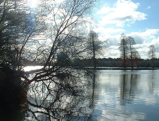
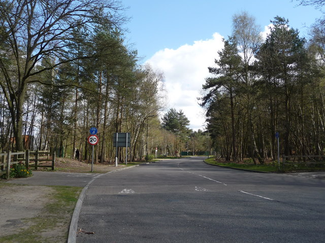
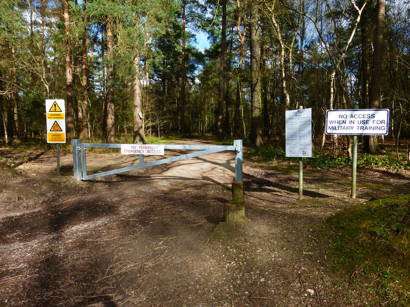
The Thorns, located in Hampshire, England, is a dense woodland area renowned for its captivating beauty and rich biodiversity. Spanning over a vast expanse, this forest is a haven for nature enthusiasts and an ideal retreat for those seeking tranquility and solace.

The terrain of The Thorns is characterized by towering, ancient trees such as oak, beech, and birch, which create a majestic canopy overhead. These trees, some of which are several centuries old, provide a sanctuary for a diverse range of flora and fauna. The forest floor is adorned with a carpet of ferns, wildflowers, and mosses, lending an ethereal ambiance to the surroundings.

Wildlife thrives within the depths of The Thorns. Visitors may encounter a plethora of creatures, including deer, foxes, badgers, and a vast array of bird species. The forest's diverse ecosystem supports a myriad of insects and small mammals as well, contributing to its ecological significance.

Walking trails wind their way through the woods, offering visitors the opportunity to explore The Thorns at their own pace. These trails provide an immersive experience, allowing individuals to soak in the serene atmosphere and witness the ever-changing colors and textures of the forest.

The Thorns, with its untouched beauty and captivating serenity, serves as a cherished natural treasure in Hampshire. Its preservation and conservation efforts ensure that future generations can continue to appreciate and marvel at the enchanting wonders of this woodland sanctuary.

If you have any feedback on the listing, please let us know in the comments section below.

The Thorns Images

Images are sourced within 2km of 51.297519/-0.8003376 or Grid Reference SU8356. Thanks to Geograph Open Source API. All images are credited.

Hawley From the road bridge at J4A in the M3, looking southwest across the middle of the square.
Hawley
From the road bridge at J4A in the M3, looking southwest across the middle of the square.
Rafborough The famous Monkey Puzzle roundabout (with the tree in the background) just north of Farnborough Aerodrome in Hampshire.
Rafborough
The famous Monkey Puzzle roundabout (with the tree in the background) just north of Farnborough Aerodrome in Hampshire.
Farnborough, Hants Looking south towards Farnborough Aerodrome and the Frank Whittle Memorial jet aircraft on the plinth outside the gate.
Farnborough, Hants
Looking south towards Farnborough Aerodrome and the Frank Whittle Memorial jet aircraft on the plinth outside the gate.
West Heath Manor School. This square is largely residential, traversed by the M3 Motorway.
West Heath
Manor School. This square is largely residential, traversed by the M3 Motorway.
Fleet Pond from the north east Pleasant place to visit.
Fleet Pond from the north east
Pleasant place to visit.
M3 Motorway and Ancells Business Park, Fleet This square has the M3 motorway passing through it, but is otherwise made up of fields and woods used for MOD training. Ancells Business Park occupies part of the SW section, this photo shows some of its buildings in the distance, taken from the disused bridge crossing the motorway.
M3 Motorway and Ancells Business Park, Fleet
This square has the M3 motorway passing through it, but is otherwise made up of fields and woods used for MOD training. Ancells Business Park occupies part of the SW section, this photo shows some of its buildings in the distance, taken from the disused bridge crossing the motorway.
Kenilworth Road Kenilworth Road at midnight during lightning storm in September 2005.
Kenilworth Road
Kenilworth Road at midnight during lightning storm in September 2005.
Nokia Southwood Familiar to anyone heading to the M3 from Southwood is the entrance to the large Nokia site.
Photograph taken with Sony Cybershot DSC-U30.
Nokia Southwood
Familiar to anyone heading to the M3 from Southwood is the entrance to the large Nokia site. Photograph taken with Sony Cybershot DSC-U30.
Bridleway through the woodland of Hawley Common, Hampshire This is the one that starts as Woodlands Walk off Fernhill Road, and then goes straight down to Hawley Lake.
Bridleway through the woodland of Hawley Common, Hampshire
This is the one that starts as Woodlands Walk off Fernhill Road, and then goes straight down to Hawley Lake.
Bridleway on Hawley Common, Hampshire This is looking NW on the bridleway from West Heath to Minley.
Bridleway on Hawley Common, Hampshire
This is looking NW on the bridleway from West Heath to Minley.
Bridleway on Hawley Common, Hampshire This is looking SE on the bridleway from West Heath to Minley.
Bridleway on Hawley Common, Hampshire
This is looking SE on the bridleway from West Heath to Minley.
Hawley Lake and sailing club near M3J4a A bleak winter's day at the lake; a cormorant stretches its wings, optimistic ducks stay close.
Hawley Lake and sailing club near M3J4a
A bleak winter's day at the lake; a cormorant stretches its wings, optimistic ducks stay close.
Hawley Lake in Winter, 2006 Wonderful place for dog-walking (unless yours leaps into water) but look out for any soldiers in camouflage or you might not even notice them!
Hawley Lake in Winter, 2006
Wonderful place for dog-walking (unless yours leaps into water) but look out for any soldiers in camouflage or you might not even notice them!
Jean and Charlie near Hawley Lake Winter, dog-walking in the pine trees beside Hawley Lake
Jean and Charlie near Hawley Lake
Winter, dog-walking in the pine trees beside Hawley Lake
Back Garden
Back Garden
Road through woods Got lost as all the roads looked the same around here.  Stopped off to snap this one
Road through woods
Got lost as all the roads looked the same around here. Stopped off to snap this one
Cody Technology Park Qinetiq buildings near Farnborough airfield. The new road layout confused the photographer.
Cody Technology Park
Qinetiq buildings near Farnborough airfield. The new road layout confused the photographer.
Southwood Business Park Units on Armstrong Mall.
Southwood Business Park
Units on Armstrong Mall.
Show me another place!

The Thorns is located at Grid Ref: SU8356 (Lat: 51.297519, Lng: -0.8003376)

Administrative County: Hampshire

District: Hart

Police Authority: Hampshire

What 3 Words

///learn.power.nightlife. Near Fleet, Hampshire

Related Wikis

South East England

South East England is one of the nine official regions of England in the United Kingdom at the first level of ITL for statistical purposes. It consists...

Cove, Hampshire

Cove is an ancient village turned suburb, forming the western part of Farnborough in the county of Hampshire in the south-east of England. The appropriate...

Fleet Spurs F.C.

Fleet Spurs Football Club are a football club based in Fleet, England. They play in the Hampshire Premier League Senior Division. The club is affiliated...

Guillemont Barracks

Guillemont Barracks, located just off of junction 4a of the M3, on the Minley Road (A327), was a military installation at Minley in Hampshire. == History... ==

Foxlease and Ancells Meadows

Foxlease and Ancells Meadows is a 68.8-hectare (170-acre) biological Site of Special Scientific Interest on the western outskirts of Farnborough in Hampshire...

Southwood Camp

Southwood Camp was a military installation at Southwood in Hampshire. == History == The camp was completed in 1939 and was used by Canadian signals and...

Bramshot Halt railway station

Bramshot Halt railway station served the adjacent Bramshot Golf Course from 1913 to 1946 on the London and Southampton Railway and was located between...

Southwood, Hampshire

Southwood is a suburb of Farnborough, in the borough of Rushmoor and adjacent to Cove. It is part of the Cove and Southwood ward. == History == The land...

Nearby Amenities

Located within 500m of 51.297519,-0.8003376
Mini Roundabout
Lat/Long: 51.2968138/-0.7937936
Crossing
Bicycle: yes
Crossing: unmarked
Crossing Island: yes
Crossing Markings: no
Kerb: lowered
Tactile Paving: yes
Lat/Long: 51.2936914/-0.7967923
Traffic Signals
Source: seen on journey
Traffic Signals Direction: backward
Lat/Long: 51.2941389/-0.8033263
Mini Roundabout
Direction: clockwise
Lat/Long: 51.297886/-0.7931769
Post Box
Collection Times: Mo-Fr 09:00; Sa 07:00
Ref: GU14 72D
Royal Cypher: EIIR
Royal Cypher Wikidata: Q33102113
Lat/Long: 51.2935925/-0.7993222
Barrier: bollard
Bollard: foldable
Lat/Long: 51.3011712/-0.8004875
The Bungalow
Building: house
Source: OS_OpenData_StreetView
Lat/Long: 51.2983154/-0.8064223
Barrier: cycle_barrier
Cycle Barrier: double
Cycle Barrier Installation: fixed
Lat/Long: 51.3001453/-0.7963921
Traffic Calming: bump
Lat/Long: 51.3003011/-0.7956683
Crossing
Crossing: uncontrolled
Crossing Markings: yes
Traffic Calming: table
Lat/Long: 51.2953471/-0.795183
Crossing
Crossing: uncontrolled
Crossing Markings: yes
Traffic Calming: table
Lat/Long: 51.2949962/-0.7946
Crossing
Crossing: uncontrolled
Kerb: lowered
Sloped Curb: yes
Traffic Calming: choker
Lat/Long: 51.2942239/-0.7962151
Barrier: bollard
Lat/Long: 51.2936237/-0.796783
Traffic Signals
Source: guess
Traffic Signals Direction: backward
Lat/Long: 51.293981/-0.8031273
Traffic Signals
Source: seen on journey
Traffic Signals Direction: backward
Lat/Long: 51.2940838/-0.8028115
Traffic Signals
Source: seen on journey
Traffic Signals Direction: backward
Lat/Long: 51.2942123/-0.8033229
Traffic Signals
Source: seen on journey
Traffic Signals Direction: backward
Lat/Long: 51.2939736/-0.8032297
Traffic Signals
Source: seen on journey
Traffic Signals Direction: backward
Lat/Long: 51.2940078/-0.8027633
Bus Stop
Trunk Road
Bench: no
Bin: no
Bus: yes
Departures Board: no
Public Transport: platform
Shelter: no
Tactile Paving: no
Lat/Long: 51.2936724/-0.7974348
Bramshot Farm Country Park
Leisure: park
Lat/Long: 51.2958954/-0.8054125
Generator Method: photovoltaic
Generator Output Electricity: yes
Generator Source: solar
Generator Type: solar_photovoltaic_panel
Location: roof
Power: generator
Lat/Long: 51.2959416/-0.797066
Generator Method: photovoltaic
Generator Output Electricity: yes
Generator Source: solar
Generator Type: solar_photovoltaic_panel
Location: roof
Power: generator
Lat/Long: 51.2957856/-0.7979323
Crossing
Crossing: unmarked
Crossing Island: no
Tactile Paving: no
Lat/Long: 51.2961839/-0.7958946
Crossing
Crossing: marked
Lat/Long: 51.2936563/-0.80387
Crossing
Crossing: marked
Lat/Long: 51.293837/-0.8040375
Crossing
Crossing: marked
Lat/Long: 51.2937444/-0.8037521
Give Way
Direction: forward
Lat/Long: 51.2939182/-0.8040582
Crossing
Crossing: marked
Lat/Long: 51.2938914/-0.8040416
Traffic Calming: yes
Lat/Long: 51.2999706/-0.7948065
Traffic Calming: yes
Lat/Long: 51.2989617/-0.7954242
Bus Stop
Broadhurst
Bench: no
Bin: no
Bus: yes
Departures Board: no
Lit: no
Public Transport: platform
Shelter: no
Tactile Paving: no
Lat/Long: 51.2977822/-0.7932949
Give Way
Lat/Long: 51.2954022/-0.795285
The data included in this document is from www.openstreetmap.org. The data is made available under ODbL.

Have you been to The Thorns?

Leave your review of The Thorns below (or comments, questions and feedback).