Horton, East

Settlement in Northumberland

England

Horton, East

Cup and ring marked rock at Buttony Cup and ring marked rock at Buttony, in the depths of a small plantation.  This site is known as 'Buttony 4' in specialist literature.

This photograph was taken during the Coronavirus (COVID-19) pandemic of 2020/21/22.
Cup and ring marked rock at Buttony Credit: James T M Towill

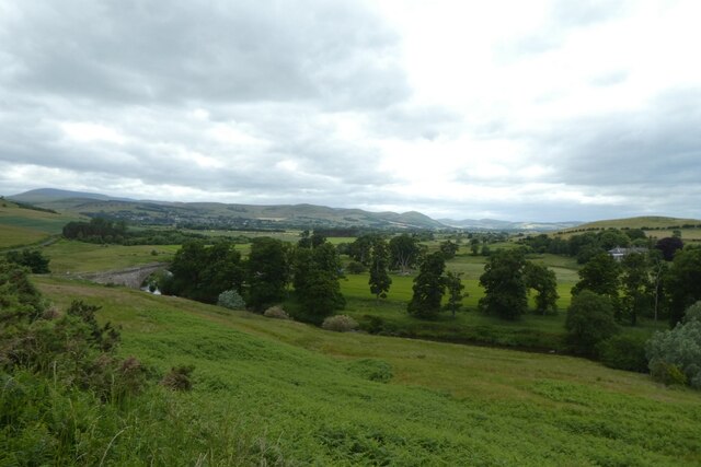
Horton is a small village located in the county of Northumberland, in the northeast of England. Situated in the eastern part of the county, it falls within the administrative district of Northumberland County Council. The village is nestled in a picturesque rural setting, surrounded by rolling hills and farmland.

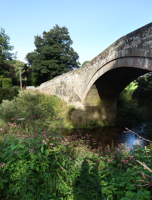
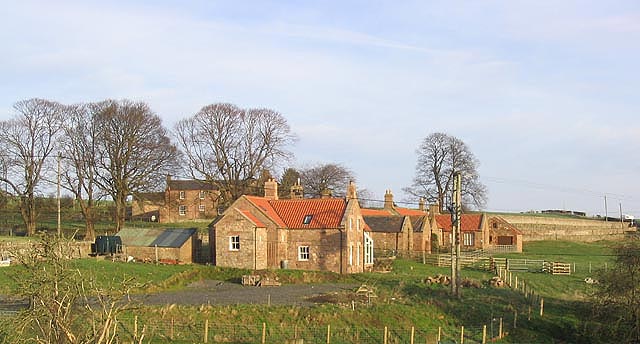
With a population of around 300 residents, Horton is a close-knit community that exudes a sense of tranquility and charm. The village is known for its quaint, traditional architecture, with many stone-built houses and cottages dating back several centuries. The local church, St. John the Baptist, is a notable landmark, showcasing beautiful stained glass windows and intricate stonework.

Agriculture plays a significant role in Horton's economy, with farming being the primary occupation for many residents. The fertile land in the area allows for the cultivation of crops such as wheat, barley, and oats, as well as the rearing of livestock.

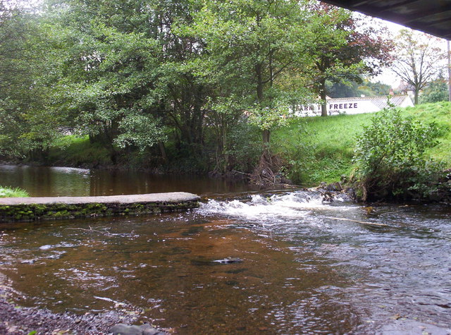
Horton is surrounded by a wealth of natural beauty, making it popular among outdoor enthusiasts. The nearby Cheviot Hills offer opportunities for hiking and exploring, with stunning vistas and meandering trails. Additionally, the village is located within close proximity to the Northumberland National Park, providing access to even more scenic landscapes and diverse wildlife.

While Horton may be a small village, it benefits from its proximity to larger towns such as Alnwick and Morpeth, where residents can access a wider range of amenities, including shops, schools, and healthcare facilities.

If you have any feedback on the listing, please let us know in the comments section below.

Horton, East Images

Images are sourced within 2km of 55.572151/-1.953815 or Grid Reference NU0330. Thanks to Geograph Open Source API. All images are credited.

Cup and ring marked rock at Buttony Cup and ring marked rock at Buttony, in the depths of a small plantation.  This site is known as 'Buttony 4' in specialist literature.

This photograph was taken during the Coronavirus (COVID-19) pandemic of 2020/21/22.
Cup and ring marked rock at Buttony
Cup and ring marked rock at Buttony, in the depths of a small plantation. This site is known as 'Buttony 4' in specialist literature. This photograph was taken during the Coronavirus (COVID-19) pandemic of 2020/21/22.
A pillbox near Buttony One of several lozenge-style polygonal pillboxes in the vicinity which formed part of the Wooler to Belford Stop Line - see <span class="nowrap"><a title="http://www.pillbox-study-group.org.uk/defence-articles/northumberland-stoplines/#:~:text=Wooler%20To%20Belford,basically%20moorland%20and%20rough%20pasture" rel="nofollow ugc noopener" href="http://www.pillbox-study-group.org.uk/defence-articles/northumberland-stoplines/#:~:text=Wooler%20To%20Belford,basically%20moorland%20and%20rough%20pasture">Link</a><img style="margin-left:2px;" alt="External link" title="External link - shift click to open in new window" src="https://s1.geograph.org.uk/img/external.png" width="10" height="10"/></span>. for further information.

This photograph was taken during the Coronavirus (COVID-19) pandemic of 2020/21/22.
A pillbox near Buttony
One of several lozenge-style polygonal pillboxes in the vicinity which formed part of the Wooler to Belford Stop Line - see LinkExternal link. for further information. This photograph was taken during the Coronavirus (COVID-19) pandemic of 2020/21/22.
A pillbox on Horton Moor One of several lozenge-style polygonal pillboxes in the vicinity which formed part of the Wooler to Belford Stop Line - see <span class="nowrap"><a title="http://www.pillbox-study-group.org.uk/defence-articles/northumberland-stoplines/#:~:text=Wooler%20To%20Belford,basically%20moorland%20and%20rough%20pasture" rel="nofollow ugc noopener" href="http://www.pillbox-study-group.org.uk/defence-articles/northumberland-stoplines/#:~:text=Wooler%20To%20Belford,basically%20moorland%20and%20rough%20pasture">Link</a><img style="margin-left:2px;" alt="External link" title="External link - shift click to open in new window" src="https://s1.geograph.org.uk/img/external.png" width="10" height="10"/></span>. for further information.

This photograph was taken during the Coronavirus (COVID-19) pandemic of 2020/21/22.
A pillbox on Horton Moor
One of several lozenge-style polygonal pillboxes in the vicinity which formed part of the Wooler to Belford Stop Line - see LinkExternal link. for further information. This photograph was taken during the Coronavirus (COVID-19) pandemic of 2020/21/22.
Doddington Moor Stone Circle Now featuring just one upright stone, nevertheless, worth a visit when exploring Doddington Moor.

This photograph was taken during the Coronavirus (COVID-19) pandemic of 2020/21/22.
Doddington Moor Stone Circle
Now featuring just one upright stone, nevertheless, worth a visit when exploring Doddington Moor. This photograph was taken during the Coronavirus (COVID-19) pandemic of 2020/21/22.
A Wood and a Wall Another picture from the south east corner of NU0430 where a short length of B6349 provides the only public access to this largely agricultural square.
A Wood and a Wall
Another picture from the south east corner of NU0430 where a short length of B6349 provides the only public access to this largely agricultural square.
B6348 and Weetwood Bridge The bridge crosses the River Till.
B6348 and Weetwood Bridge
The bridge crosses the River Till.
River Till Looking along the River Till from Weetwood Bridge.
River Till
Looking along the River Till from Weetwood Bridge.
Bridge over the River Till Looking across Weetwood Bridge. There are narrow traffic restrictions on each side of the bridge along with a weight limit.
Bridge over the River Till
Looking across Weetwood Bridge. There are narrow traffic restrictions on each side of the bridge along with a weight limit.
Slopes above the River Till Looking down towards the River Till from the B6348.
Slopes above the River Till
Looking down towards the River Till from the B6348.
B6348 climbing near Heatheryhall Looking along the B6348 heading east from Wooler.
B6348 climbing near Heatheryhall
Looking along the B6348 heading east from Wooler.
Below the road Looking down towards the River Till from the B6348.
Below the road
Looking down towards the River Till from the B6348.
B6348 above Weetwood Bridge Looking down the B6348 towards Wooler.
B6348 above Weetwood Bridge
Looking down the B6348 towards Wooler.
B6349 meets the B6348 Both roads effectively run between Wooler and Belford.
B6349 meets the B6348
Both roads effectively run between Wooler and Belford.
View across the Till Valley Fields and woods east of Wooler.
View across the Till Valley
Fields and woods east of Wooler.
Along the B6348 A country road past fields and woods.
Along the B6348
A country road past fields and woods.
Weak Bridge Warning Fowberry Bridge over the River Till is very old, very narrow and unsuitable for any traffic other than cars and small vans.
These warning signs are prominent on both sides of the bridge, and solid stone pillars enforce the width restriction.
I am amazed that this is the same place as <a href="https://www.geograph.org.uk/photo/4574613">NU0329 : Fowberry Bridge over the River Till</a> from 8 years ago. What has happened to the neat lawns and roadway shown in that picture? Over the wall now, as you see, it's a mess of old weeds and dumped stuff spoiling the view of the bridge.
Weak Bridge Warning
Fowberry Bridge over the River Till is very old, very narrow and unsuitable for any traffic other than cars and small vans. These warning signs are prominent on both sides of the bridge, and solid stone pillars enforce the width restriction. I am amazed that this is the same place as NU0329 : Fowberry Bridge over the River Till from 8 years ago. What has happened to the neat lawns and roadway shown in that picture? Over the wall now, as you see, it's a mess of old weeds and dumped stuff spoiling the view of the bridge.
Fowberry Bridge Part of the bridge viewed from the public footpath which still goes through the weeds which have taken over the river bank in recent years. My ghostly shadow is standing roughly in the middle of the scene shown in this picture from 8 years ago <a href="https://www.geograph.org.uk/photo/4574613">NU0329 : Fowberry Bridge over the River Till</a>
Fowberry Bridge
Part of the bridge viewed from the public footpath which still goes through the weeds which have taken over the river bank in recent years. My ghostly shadow is standing roughly in the middle of the scene shown in this picture from 8 years ago NU0329 : Fowberry Bridge over the River Till
Post Box, Hetton House Beside B6349 outside Hetton House.
Post Box, Hetton House
Beside B6349 outside Hetton House.
Show me another place!

Horton, East is located at Grid Ref: NU0330 (Lat: 55.572151, Lng: -1.953815)

Unitary Authority: Northumberland

Police Authority: Northumbria

What 3 Words

///respected.points.strange. Near Doddington, Northumberland

Related Wikis

Horton, Chatton

Horton is a pair of small settlements, West Horton and East Horton, divided by a stream - the Horton Burn - in Northumberland, England 3 miles (5 km) north...

Fowberry Tower

Fowberry Tower is a Grade II* listed mansion house, situated on the banks of the River Till, near Chatton, Northumberland.The Manor of Fowberry was owned...

Wooler Water

Wooler Water is a stream that flows through Wooler in Northumberland, England. It is a tributary of the River Till and is 12 miles (20 km) in length. Its...

Berwick-upon-Tweed (UK Parliament constituency)

Berwick-upon-Tweed ( ) is a parliamentary constituency in Northumberland represented in the House of Commons of the UK Parliament since 2015 by Anne-Marie...

Nearby Amenities

Located within 500m of 55.572151,-1.953815
West Horton
Place: hamlet
Lat/Long: 55.571495/-1.9607874
East Horton
Place: locality
Lat/Long: 55.5722654/-1.9554598
Telephone
Booth: KX100
Covered: booth
Lat/Long: 55.5715449/-1.9564089
Post Box
Post Box Design: hovis
Post Box Mounting: wall
Post Box Type: lamp
Ref: NE66 21
Royal Cypher: GR
Royal Cypher Wikidata: Q33102273
Lat/Long: 55.571555/-1.9567428
Direction: 165
Generator Method: photovoltaic
Generator Output Electricity: yes
Generator Solar Modules: 16
Generator Source: solar
Generator Type: solar_photovoltaic_panel
Location: roof
Power: generator
Lat/Long: 55.5718273/-1.9580089
East Horton Farmhouse
Addr City: East Horton
Addr Postcode: NE71 6EZ
Guest House: bed_and_breakfast
Phone: +44 1668 215 216
Tourism: guest_house
Website: http://www.farmhousebandb.co.uk
Lat/Long: 55.5718922/-1.9550555
The data included in this document is from www.openstreetmap.org. The data is made available under ODbL.

Have you been to Horton, East?

Leave your review of Horton, East below (or comments, questions and feedback).