Ancels Copse

Wood, Forest in Hampshire Hart

England

Ancels Copse

Hawley From the road bridge at J4A in the M3, looking southwest across the middle of the square.
Hawley Credit: Brendan and Ruth McCartney

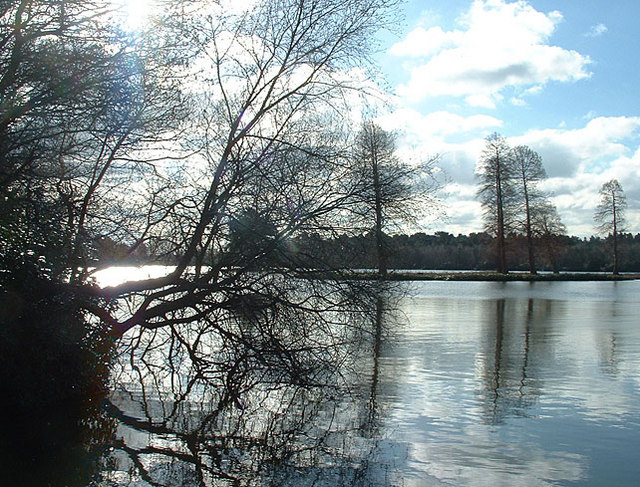
Ancels Copse is a picturesque woodland located in Hampshire, England. Covering an area of approximately 50 acres, this enchanting copse is renowned for its natural beauty and diverse ecosystem. It is situated near the village of Bramshott, nestled within the South Downs National Park.

The copse features a mixture of deciduous and coniferous trees, creating a vibrant and colorful landscape throughout the year. Ancient oaks and beech trees dominate the area, their towering presence casting a dappled shade on the forest floor. In spring, the woodland bursts into life with a carpet of bluebells, creating a breathtaking sight for visitors.

The copse is home to a wide variety of wildlife, making it a popular destination for nature enthusiasts. Birdwatchers can spot a range of species, including woodpeckers, nuthatches, and jays. Squirrels scurry among the branches, while deer can occasionally be seen grazing in the more secluded areas.

Ancels Copse offers numerous walking trails, allowing visitors to explore its hidden corners and discover its natural treasures. There are also picnic areas and benches scattered throughout the copse, providing the perfect opportunity for visitors to relax and enjoy the tranquil surroundings.

Managed by the local authorities, Ancels Copse is a protected area that is carefully conserved for future generations. It offers a peaceful retreat from the hustle and bustle of everyday life, providing a haven for both wildlife and humans alike. Whether you are a nature lover, a photographer, or simply seeking a place to unwind, Ancels Copse is a must-visit destination in Hampshire.

If you have any feedback on the listing, please let us know in the comments section below.

Ancels Copse Images

Images are sourced within 2km of 51.299131/-0.81476854 or Grid Reference SU8256. Thanks to Geograph Open Source API. All images are credited.

Hawley From the road bridge at J4A in the M3, looking southwest across the middle of the square.
Hawley
From the road bridge at J4A in the M3, looking southwest across the middle of the square.
Fleet, Hants Fleet railway station, providing a busy commuter link to London.
Fleet, Hants
Fleet railway station, providing a busy commuter link to London.
Fleet Looking southwest along the M3 from the bridge on the B3013. The rest of the square is a mixture of wood and farmland.
Fleet
Looking southwest along the M3 from the bridge on the B3013. The rest of the square is a mixture of wood and farmland.
Fleet Looking northeast along the M3 from the bridge on the B3013. The rest of the square is a mixture of woods, farmland and some office blocks to the south.
Fleet
Looking northeast along the M3 from the bridge on the B3013. The rest of the square is a mixture of woods, farmland and some office blocks to the south.
Fleet Pond from the north east Pleasant place to visit.
Fleet Pond from the north east
Pleasant place to visit.
M3 Motorway and Ancells Business Park, Fleet This square has the M3 motorway passing through it, but is otherwise made up of fields and woods used for MOD training. Ancells Business Park occupies part of the SW section, this photo shows some of its buildings in the distance, taken from the disused bridge crossing the motorway.
M3 Motorway and Ancells Business Park, Fleet
This square has the M3 motorway passing through it, but is otherwise made up of fields and woods used for MOD training. Ancells Business Park occupies part of the SW section, this photo shows some of its buildings in the distance, taken from the disused bridge crossing the motorway.
Union of South Africa Approaching Fleet Station after a day out to Southampton
Union of South Africa
Approaching Fleet Station after a day out to Southampton
Kenilworth Road Kenilworth Road at midnight during lightning storm in September 2005.
Kenilworth Road
Kenilworth Road at midnight during lightning storm in September 2005.
Minley Road Closed For RTA Christmas Eve 2004. I personally would have preferred this picture if the police hadn't closed the road for a car accident, mind you they were sweeping up the remains of my car!

Photograph taken with Sony Cybershot DSC-U30.
Minley Road Closed For RTA
Christmas Eve 2004. I personally would have preferred this picture if the police hadn't closed the road for a car accident, mind you they were sweeping up the remains of my car! Photograph taken with Sony Cybershot DSC-U30.
Nokia Southwood Familiar to anyone heading to the M3 from Southwood is the entrance to the large Nokia site.
Photograph taken with Sony Cybershot DSC-U30.
Nokia Southwood
Familiar to anyone heading to the M3 from Southwood is the entrance to the large Nokia site. Photograph taken with Sony Cybershot DSC-U30.
Hawley Lake and sailing club near M3J4a A bleak winter's day at the lake; a cormorant stretches its wings, optimistic ducks stay close.
Hawley Lake and sailing club near M3J4a
A bleak winter's day at the lake; a cormorant stretches its wings, optimistic ducks stay close.
Hawley Lake in Winter, 2006 Wonderful place for dog-walking (unless yours leaps into water) but look out for any soldiers in camouflage or you might not even notice them!
Hawley Lake in Winter, 2006
Wonderful place for dog-walking (unless yours leaps into water) but look out for any soldiers in camouflage or you might not even notice them!
Road through woods Got lost as all the roads looked the same around here.  Stopped off to snap this one
Road through woods
Got lost as all the roads looked the same around here. Stopped off to snap this one
Footpath near Fleet Pond Path alongside Gelvert Stream heading away from the pond.
Footpath near Fleet Pond
Path alongside Gelvert Stream heading away from the pond.
Fields at Minley Farm Looking east from the B3013.
Fields at Minley Farm
Looking east from the B3013.
Fleet Pond From Sand Bay where Gelvert Stream flows in.
Fleet Pond
From Sand Bay where Gelvert Stream flows in.
Fleet Pond The marshy shoreline at Fugelmere Bay.
Fleet Pond
The marshy shoreline at Fugelmere Bay.
Gelvert Stream The stream flows north to feed Fleet Pond.
Gelvert Stream
The stream flows north to feed Fleet Pond.
Show me another place!

Ancels Copse is located at Grid Ref: SU8256 (Lat: 51.299131, Lng: -0.81476854)

Administrative County: Hampshire

District: Hart

Police Authority: Hampshire

What 3 Words

///populate.mainland.earpiece. Near Fleet, Hampshire

Related Wikis

Foxlease and Ancells Meadows

Foxlease and Ancells Meadows is a 68.8-hectare (170-acre) biological Site of Special Scientific Interest on the western outskirts of Farnborough in Hampshire...

Ancells Farm

Ancells Farm is a 12-hectare (30-acre) nature reserve in Fleet in Hampshire. It is managed by the Hampshire and Isle of Wight Wildlife Trust. It is part...

Bramshot Halt railway station

Bramshot Halt railway station served the adjacent Bramshot Golf Course from 1913 to 1946 on the London and Southampton Railway and was located between...

South East England

South East England is one of the nine official regions of England in the United Kingdom at the first level of ITL for statistical purposes. It consists...

Nearby Amenities

Located within 500m of 51.299131,-0.81476854
Phone
Emergency: phone
Operator: National Highways
Operator Wikidata: Q5760006
Lat/Long: 51.3012034/-0.8086102
The data included in this document is from www.openstreetmap.org. The data is made available under ODbL.

Have you been to Ancels Copse?

Leave your review of Ancels Copse below (or comments, questions and feedback).