Drew's Wood

Wood, Forest in Oxfordshire South Oxfordshire

England

Drew's Wood

Pasture, Greys The edge of a field to the north of Shepherd's Green.
Pasture, Greys Credit: Andrew Smith

Drew's Wood is a picturesque woodland located in Oxfordshire, England. Spanning over 100 acres, this enchanting forest is a haven for nature lovers and outdoor enthusiasts. Situated just a few miles outside the town of Oxford, Drew's Wood offers a serene and tranquil escape from the hustle and bustle of city life.

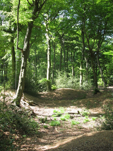
The woodland is characterized by its dense canopy of towering trees, primarily made up of oak, beech, and ash. These majestic trees provide a sense of grandeur as visitors wander along the well-maintained trails that crisscross the wood. The forest floor is adorned with a rich carpet of ferns, bluebells, and other wildflowers, creating a vibrant and colorful landscape during spring and summer months.

Drew's Wood is not only a visual delight but also a haven for wildlife. It is home to a diverse range of species, including deer, foxes, badgers, and a variety of bird species. Nature enthusiasts can indulge in birdwatching, as the wood attracts numerous songbirds and woodpeckers.

The forest also offers a range of recreational activities for visitors. There are designated picnic areas where families and friends can gather for a leisurely outdoor meal. The well-marked trails are perfect for hiking, jogging, or cycling, allowing visitors to explore the wood at their own pace.

Drew's Wood is a cherished natural gem in Oxfordshire, providing a sanctuary for both humans and wildlife alike. Its idyllic setting and diverse flora and fauna make it a must-visit destination for anyone seeking a peaceful and rejuvenating experience in the heart of nature.

If you have any feedback on the listing, please let us know in the comments section below.

Drew's Wood Images

Images are sourced within 2km of 51.559041/-0.95643423 or Grid Reference SU7284. Thanks to Geograph Open Source API. All images are credited.

Pasture, Greys The edge of a field to the north of Shepherd's Green.
Pasture, Greys
The edge of a field to the north of Shepherd's Green.
Hollow at Famous Copse One of several old clay and flint pits in this area. This one has a rope swing.
Hollow at Famous Copse
One of several old clay and flint pits in this area. This one has a rope swing.
It's not a joke Warning sign in front of the ha ha at Greys Court. As well as a wall the ha ha hides a pond.
It's not a joke
Warning sign in front of the ha ha at Greys Court. As well as a wall the ha ha hides a pond.
Grey's Court House 16th century tudor mansion used as a family home until 2003
Grey's Court House
16th century tudor mansion used as a family home until 2003
Tower House & Tower, Grey's Court Greys Court is a Tudor country house and associated gardens, located at the southern end of the Chiltern Hills at Rotherfield Greys, near Henley-on-Thames in Oxfordshire. It is owned by the National Trust.

The name derives from an old connection to the Grey family, descendants of the Norman knight Anchetil de Greye. The estate or manor of Rotherfield Greys upon which Greys Court is situated is specifically mentioned in the Domesday Book. <span class="nowrap"><a title="http://en.wikipedia.org/wiki/Greys_Court" rel="nofollow ugc noopener" href="http://en.wikipedia.org/wiki/Greys_Court">Link</a><img style="margin-left:2px;" alt="External link" title="External link - shift click to open in new window" src="https://s1.geograph.org.uk/img/external.png" width="10" height="10"/></span>

Website: <span class="nowrap"><a title="http://www.nationaltrust.org.uk/main/w-greyscourt" rel="nofollow ugc noopener" href="http://www.nationaltrust.org.uk/main/w-greyscourt">Link</a><img style="margin-left:2px;" alt="External link" title="External link - shift click to open in new window" src="https://s1.geograph.org.uk/img/external.png" width="10" height="10"/></span>
Tower House & Tower, Grey's Court
Greys Court is a Tudor country house and associated gardens, located at the southern end of the Chiltern Hills at Rotherfield Greys, near Henley-on-Thames in Oxfordshire. It is owned by the National Trust. The name derives from an old connection to the Grey family, descendants of the Norman knight Anchetil de Greye. The estate or manor of Rotherfield Greys upon which Greys Court is situated is specifically mentioned in the Domesday Book. LinkExternal link Website: LinkExternal link
Farmland south of Grey's Court
Heart shaped pond - Grey's Court Part of the formal gardens to the east of the house
Heart shaped pond - Grey's Court
Part of the formal gardens to the east of the house
Formal Garden - Grey's Court Greys Court is a Tudor country house and associated gardens, located at the southern end of the Chiltern Hills at Rotherfield Greys, near Henley-on-Thames in Oxfordshire. It is owned by the National Trust.

The name derives from an old connection to the Grey family, descendants of the Norman knight Anchetil de Greye. The estate or manor of Rotherfield Greys upon which Greys Court is situated is specifically mentioned in the Domesday Book. <span class="nowrap"><a title="http://en.wikipedia.org/wiki/Greys_Court" rel="nofollow ugc noopener" href="http://en.wikipedia.org/wiki/Greys_Court">Link</a><img style="margin-left:2px;" alt="External link" title="External link - shift click to open in new window" src="https://s1.geograph.org.uk/img/external.png" width="10" height="10"/></span>

Website: <span class="nowrap"><a title="http://www.nationaltrust.org.uk/main/w-greyscourt" rel="nofollow ugc noopener" href="http://www.nationaltrust.org.uk/main/w-greyscourt">Link</a><img style="margin-left:2px;" alt="External link" title="External link - shift click to open in new window" src="https://s1.geograph.org.uk/img/external.png" width="10" height="10"/></span>
Formal Garden - Grey's Court
Greys Court is a Tudor country house and associated gardens, located at the southern end of the Chiltern Hills at Rotherfield Greys, near Henley-on-Thames in Oxfordshire. It is owned by the National Trust. The name derives from an old connection to the Grey family, descendants of the Norman knight Anchetil de Greye. The estate or manor of Rotherfield Greys upon which Greys Court is situated is specifically mentioned in the Domesday Book. LinkExternal link Website: LinkExternal link
Tower at Grey's Court Viewed from the formal garden
Tower at Grey's Court
Viewed from the formal garden
Ice House - Grey's Court 19th century thatched out building in the grounds of Grey's Court
Ice House - Grey's Court
19th century thatched out building in the grounds of Grey's Court
Grey's Court grounds Greys Court is a Tudor country house and associated gardens, located at the southern end of the Chiltern Hills at Rotherfield Greys, near Henley-on-Thames in Oxfordshire. It is owned by the National Trust.

The name derives from an old connection to the Grey family, descendants of the Norman knight Anchetil de Greye. The estate or manor of Rotherfield Greys upon which Greys Court is situated is specifically mentioned in the Domesday Book. <span class="nowrap"><a title="http://en.wikipedia.org/wiki/Greys_Court" rel="nofollow ugc noopener" href="http://en.wikipedia.org/wiki/Greys_Court">Link</a><img style="margin-left:2px;" alt="External link" title="External link - shift click to open in new window" src="https://s1.geograph.org.uk/img/external.png" width="10" height="10"/></span>

Website: <span class="nowrap"><a title="http://www.nationaltrust.org.uk/main/w-greyscourt" rel="nofollow ugc noopener" href="http://www.nationaltrust.org.uk/main/w-greyscourt">Link</a><img style="margin-left:2px;" alt="External link" title="External link - shift click to open in new window" src="https://s1.geograph.org.uk/img/external.png" width="10" height="10"/></span>
Grey's Court grounds
Greys Court is a Tudor country house and associated gardens, located at the southern end of the Chiltern Hills at Rotherfield Greys, near Henley-on-Thames in Oxfordshire. It is owned by the National Trust. The name derives from an old connection to the Grey family, descendants of the Norman knight Anchetil de Greye. The estate or manor of Rotherfield Greys upon which Greys Court is situated is specifically mentioned in the Domesday Book. LinkExternal link Website: LinkExternal link
Footbridge over Ha-Ha In the grounds of Grey's Court
Footbridge over Ha-Ha
In the grounds of Grey's Court
Tower at Grey's Court viewed from the formal gardens
Tower at Grey's Court
viewed from the formal gardens
Grey's Court gardens Greys Court is a Tudor country house and associated gardens, located at the southern end of the Chiltern Hills at Rotherfield Greys, near Henley-on-Thames in Oxfordshire. It is owned by the National Trust.

The name derives from an old connection to the Grey family, descendants of the Norman knight Anchetil de Greye. The estate or manor of Rotherfield Greys upon which Greys Court is situated is specifically mentioned in the Domesday Book. <span class="nowrap"><a title="http://en.wikipedia.org/wiki/Greys_Court" rel="nofollow ugc noopener" href="http://en.wikipedia.org/wiki/Greys_Court">Link</a><img style="margin-left:2px;" alt="External link" title="External link - shift click to open in new window" src="https://s1.geograph.org.uk/img/external.png" width="10" height="10"/></span>

Website: <span class="nowrap"><a title="http://www.nationaltrust.org.uk/main/w-greyscourt" rel="nofollow ugc noopener" href="http://www.nationaltrust.org.uk/main/w-greyscourt">Link</a><img style="margin-left:2px;" alt="External link" title="External link - shift click to open in new window" src="https://s1.geograph.org.uk/img/external.png" width="10" height="10"/></span>
Grey's Court gardens
Greys Court is a Tudor country house and associated gardens, located at the southern end of the Chiltern Hills at Rotherfield Greys, near Henley-on-Thames in Oxfordshire. It is owned by the National Trust. The name derives from an old connection to the Grey family, descendants of the Norman knight Anchetil de Greye. The estate or manor of Rotherfield Greys upon which Greys Court is situated is specifically mentioned in the Domesday Book. LinkExternal link Website: LinkExternal link
Statue in Walled Garden -Grey's Court Greys Court is a Tudor country house and associated gardens, located at the southern end of the Chiltern Hills at Rotherfield Greys, near Henley-on-Thames in Oxfordshire. It is owned by the National Trust.

The name derives from an old connection to the Grey family, descendants of the Norman knight Anchetil de Greye. The estate or manor of Rotherfield Greys upon which Greys Court is situated is specifically mentioned in the Domesday Book. <span class="nowrap"><a title="http://en.wikipedia.org/wiki/Greys_Court" rel="nofollow ugc noopener" href="http://en.wikipedia.org/wiki/Greys_Court">Link</a><img style="margin-left:2px;" alt="External link" title="External link - shift click to open in new window" src="https://s1.geograph.org.uk/img/external.png" width="10" height="10"/></span>

Website: <span class="nowrap"><a title="http://www.nationaltrust.org.uk/main/w-greyscourt" rel="nofollow ugc noopener" href="http://www.nationaltrust.org.uk/main/w-greyscourt">Link</a><img style="margin-left:2px;" alt="External link" title="External link - shift click to open in new window" src="https://s1.geograph.org.uk/img/external.png" width="10" height="10"/></span>
Statue in Walled Garden -Grey's Court
Greys Court is a Tudor country house and associated gardens, located at the southern end of the Chiltern Hills at Rotherfield Greys, near Henley-on-Thames in Oxfordshire. It is owned by the National Trust. The name derives from an old connection to the Grey family, descendants of the Norman knight Anchetil de Greye. The estate or manor of Rotherfield Greys upon which Greys Court is situated is specifically mentioned in the Domesday Book. LinkExternal link Website: LinkExternal link
Garlanded seat - Grey's Court Located in the Walled Garden
Garlanded seat - Grey's Court
Located in the Walled Garden
Maze - Grey's Court Greys Court is a Tudor country house and associated gardens, located at the southern end of the Chiltern Hills at Rotherfield Greys, near Henley-on-Thames in Oxfordshire. It is owned by the National Trust.

The name derives from an old connection to the Grey family, descendants of the Norman knight Anchetil de Greye. The estate or manor of Rotherfield Greys upon which Greys Court is situated is specifically mentioned in the Domesday Book. <span class="nowrap"><a title="http://en.wikipedia.org/wiki/Greys_Court" rel="nofollow ugc noopener" href="http://en.wikipedia.org/wiki/Greys_Court">Link</a><img style="margin-left:2px;" alt="External link" title="External link - shift click to open in new window" src="https://s1.geograph.org.uk/img/external.png" width="10" height="10"/></span>

Website: <span class="nowrap"><a title="http://www.nationaltrust.org.uk/main/w-greyscourt" rel="nofollow ugc noopener" href="http://www.nationaltrust.org.uk/main/w-greyscourt">Link</a><img style="margin-left:2px;" alt="External link" title="External link - shift click to open in new window" src="https://s1.geograph.org.uk/img/external.png" width="10" height="10"/></span>
Maze - Grey's Court
Greys Court is a Tudor country house and associated gardens, located at the southern end of the Chiltern Hills at Rotherfield Greys, near Henley-on-Thames in Oxfordshire. It is owned by the National Trust. The name derives from an old connection to the Grey family, descendants of the Norman knight Anchetil de Greye. The estate or manor of Rotherfield Greys upon which Greys Court is situated is specifically mentioned in the Domesday Book. LinkExternal link Website: LinkExternal link
Archway of Wisteria - Grey's Court in the walled gardens east of the house
Archway of Wisteria - Grey's Court
in the walled gardens east of the house
Show me another place!

Drew's Wood is located at Grid Ref: SU7284 (Lat: 51.559041, Lng: -0.95643423)

Administrative County: Oxfordshire

District: South Oxfordshire

Police Authority: Thames Valley

What 3 Words

///blown.proposals.acute. Near Rotherfield Peppard, Oxfordshire

Related Wikis

Bix, Oxfordshire

Bix is a village in the civil parish of Bix and Assendon in South Oxfordshire, about 2.5 miles (4 km) northwest of Henley-on-Thames. The village is about...

Lambridge Wood

Lambridge Wood is a 73.8-hectare (182-acre) biological Site of Special Scientific Interest north-west of Henley-on-Thames in Oxfordshire. It is in the...

Bix and Assendon

Bix and Assendon, formerly just Bix is a mainly rural civil parish in the high Chilterns just north of Henley-on-Thames in South Oxfordshire, in the county...

Middle Assendon

Middle Assendon is a village in the Stonor valley in the Chiltern Hills. It is about 2 miles (3.2 km) northwest of Henley-on-Thames in South Oxfordshire...

Rotherfield Greys Castle

Rotherfield Greys Castle, initially known as Retherfield Castle, is a 14th-century fortified manor house built in Rotherfield Greys, Oxfordshire. Only...

Greys Court

Greys Court is a Tudor country house and gardens in the southern Chiltern Hills at Rotherfield Greys, near Henley-on-Thames in the county of Oxfordshire...

Lower Assendon

Lower Assendon is a village in the Assendon valley in the Chiltern Hills, about 1.5 miles (2.4 km) northwest of Henley-on-Thames in South Oxfordshire...

Maidensgrove

Maidensgrove is a hamlet above the Stonor valley in the Chiltern Hills, adjacent to Russell's Water common. It is about 5 miles (8.0 km) northwest of...

Nearby Amenities

Located within 500m of 51.559041,-0.95643423
Maxspeed: 40 mph
Traffic Sign: maxspeed
Lat/Long: 51.5596968/-0.9501873
Bus Stop
Bix Turn
Bus: yes
Naptan AtcoCode: 340001515CNR
Naptan Bearing: SE
Naptan CommonName: Bix Turn
Naptan Indicator: Corner
Naptan Landmark: Bus Shelter
Naptan NaptanCode: oxfgdmpa
Naptan Street: A4130
Naptan Verified: no
Public Transport: platform
Shelter: yes
Source: naptan_import
Lat/Long: 51.5604576/-0.9515851
Bus Stop
Bix Turn
Naptan AtcoCode: 340001515OPP
Naptan Bearing: NW
Naptan CommonName: Bix Turn
Naptan Indicator: Opposite
Naptan Landmark: Opp Bus Shelter
Naptan NaptanCode: oxfgdmjw
Naptan Street: A4130
Naptan Verified: no
Source: naptan_import
Lat/Long: 51.5601401/-0.9515376
Barrier: stile
Foot: yes
Lat/Long: 51.5566907/-0.9566958
Barrier: stile
Foot: yes
Lat/Long: 51.5576653/-0.9573227
Barrier: stile
Foot: yes
Lat/Long: 51.557712/-0.9573344
Barrier: stile
Foot: yes
Lat/Long: 51.5580952/-0.9573846
Barrier: stile
Foot: yes
Lat/Long: 51.5581567/-0.9573867
Barrier: stile
Foot: yes
Lat/Long: 51.5593114/-0.956794
Barrier: stile
Foot: yes
Lat/Long: 51.5610776/-0.9549691
Barrier: kissing_gate
Bicycle: no
Foot: yes
Lat/Long: 51.5618377/-0.9546265
Barrier: stile
Foot: yes
Lat/Long: 51.5546759/-0.9558082
End Date: 2000
Old Amenity: pub
Old Name: The Fox
Source: survey
Source End Date: landlord of The Rainbow
Lat/Long: 51.561333/-0.9544065
Barrier: stile
Lat/Long: 51.5593293/-0.9564969
Post Box
Collection Times: Mo-Fr 16:00; Sa 10:00
Operator: Royal Mail
Operator Wikidata: Q638098
Post Box Type: lamp
Ref: RG9 73
Royal Cypher: EIIR
Royal Cypher Wikidata: Q33102113
Source: survey
Lat/Long: 51.5607127/-0.9513901
Telephone
Booth: K6
Covered: booth
Man Made: telephone_box
Operator: BT
Operator Wikidata: Q593786
Source: survey
Lat/Long: 51.5607409/-0.9513927
Direction: 220
Generator Method: photovoltaic
Generator Output Electricity: yes
Generator Solar Modules: 6
Generator Source: solar
Generator Type: solar_photovoltaic_panel
Location: roof
Power: generator
Lat/Long: 51.5613072/-0.9530189
Direction: 220
Generator Method: photovoltaic
Generator Output Electricity: yes
Generator Solar Modules: 8
Generator Source: solar
Generator Type: solar_photovoltaic_panel
Location: roof
Power: generator
Lat/Long: 51.5613394/-0.9534234
Fixme: solar panel?
Lat/Long: 51.5614301/-0.9535484
Direction: 215
Generator Method: photovoltaic
Generator Output Electricity: yes
Generator Solar Modules: 4
Generator Source: solar
Generator Type: solar_photovoltaic_panel
Location: roof
Power: generator
Lat/Long: 51.561286/-0.9545292
Direction: 200
Generator Method: photovoltaic
Generator Output Electricity: yes
Generator Solar Modules: 6
Generator Source: solar
Generator Type: solar_photovoltaic_panel
Location: roof
Power: generator
Lat/Long: 51.5612937/-0.9518678
The data included in this document is from www.openstreetmap.org. The data is made available under ODbL.

Have you been to Drew's Wood?

Leave your review of Drew's Wood below (or comments, questions and feedback).