Coldnorton Shaw

Wood, Forest in Oxfordshire South Oxfordshire

England

Coldnorton Shaw

A4074 Reading Road heading towards Wallingford Passing The Packhorse on the right ('Food and drink all day!').
A4074 Reading Road heading towards Wallingford Credit: Robin Webster

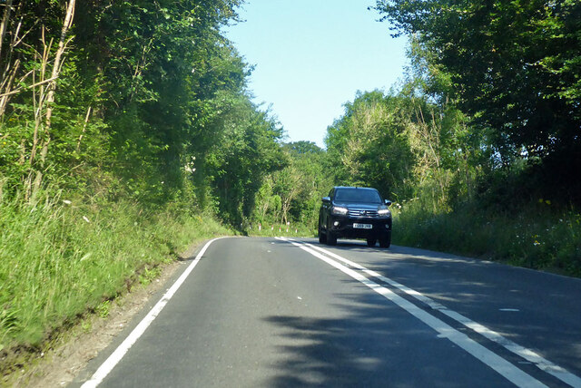
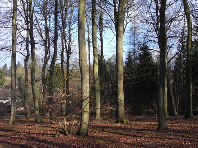
Coldnorton Shaw is a charming woodland area located in Oxfordshire, England. Situated in the heart of the county, it is known for its serene beauty and abundant wildlife. Coldnorton Shaw is primarily comprised of dense forest, with towering trees and a diverse range of flora and fauna.

Covering an area of approximately 200 acres, Coldnorton Shaw offers a peaceful escape from the hustle and bustle of city life. The forest is a popular destination for nature enthusiasts and hikers, who are drawn to its picturesque trails and quiet ambience. The woodland is home to an array of wildlife, including deer, foxes, badgers, and a variety of bird species.

The forest is managed by the local authorities and is well-maintained, ensuring that the natural ecosystem thrives. Visitors can explore the network of footpaths and bridleways that wind through the forest, providing opportunities to discover hidden nooks and crannies. Coldnorton Shaw also boasts a picnic area, where visitors can relax and soak in the tranquil surroundings.

The woodland is easily accessible, with ample parking available nearby. Local communities often organize events and activities in Coldnorton Shaw, such as guided nature walks and educational programs for children. The forest is also a popular spot for photography enthusiasts, who are captivated by the stunning landscapes and the ever-changing colors of the seasons.

Whether you are seeking a peaceful retreat or an opportunity to connect with nature, Coldnorton Shaw offers a truly enchanting experience. Its idyllic woodland setting and diverse wildlife make it a must-visit destination for nature lovers in Oxfordshire.

If you have any feedback on the listing, please let us know in the comments section below.

Coldnorton Shaw Images

Images are sourced within 2km of 51.511856/-1.0054559 or Grid Reference SU6979. Thanks to Geograph Open Source API. All images are credited.

A4074 Reading Road heading towards Wallingford Passing The Packhorse on the right ('Food and drink all day!').
A4074 Reading Road heading towards Wallingford
Passing The Packhorse on the right ('Food and drink all day!').
A4074 Reading Road heading towards Wallingford
A4074 Reading Road heading towards Wallingford Approaching Cane End.
A4074 Reading Road heading towards Wallingford
Approaching Cane End.
A4074 Reading Road, Cane End Towards Wallingford and Oxford.
A4074 Reading Road, Cane End
Towards Wallingford and Oxford.
No Trace of The Fox This place now has no resemblance to earlier photos here.
Graham Horn's picture from 15 years ago shows the building which used to be on this site until a few years ago. Then it was a large pub "The Fox" <a href="https://www.geograph.org.uk/photo/348561">SU6779 : The Fox at Cane End</a>
A later picture of mine <a href="https://www.geograph.org.uk/photo/2083210">SU6779 : Palm Tree  (Ex Fox)</a> shows it as an Indian restaurant "The Palm Tree."  
In my caption at the time I wished them luck in this tricky out of town location.
Not to be. After yet another spell as a Thai restaurant the place finally closed its doors.
Now demolished and replaced by these new houses. The only clues are the pub style sign post which now carries the developer's name board and the new cul de sac which is called Fox Heath Gardens..
No Trace of The Fox
This place now has no resemblance to earlier photos here. Graham Horn's picture from 15 years ago shows the building which used to be on this site until a few years ago. Then it was a large pub "The Fox" SU6779 : The Fox at Cane End A later picture of mine SU6779 : Palm Tree (Ex Fox) shows it as an Indian restaurant "The Palm Tree." In my caption at the time I wished them luck in this tricky out of town location. Not to be. After yet another spell as a Thai restaurant the place finally closed its doors. Now demolished and replaced by these new houses. The only clues are the pub style sign post which now carries the developer's name board and the new cul de sac which is called Fox Heath Gardens..
Sonning Common The centre of this sprawling commuter village.  There is no obvious connection with the village of Sonning on the Thames, 8km to the south-east
Sonning Common
The centre of this sprawling commuter village. There is no obvious connection with the village of Sonning on the Thames, 8km to the south-east
Catholic church of St Michael, Sonning Common On Peppard Road, B481, which bypasses the main village.  The footpath to the right leads to Woodlands Avenue and the village centre.
Catholic church of St Michael, Sonning Common
On Peppard Road, B481, which bypasses the main village. The footpath to the right leads to Woodlands Avenue and the village centre.
Odd numbers : Even numbers Sedgefield Close of course.  Somehow at the time this sign just seemed odd.  Even now it still does.
Odd numbers : Even numbers
Sedgefield Close of course. Somehow at the time this sign just seemed odd. Even now it still does.
Orchard Avenue Typical residential street in Sonning Common.
Orchard Avenue
Typical residential street in Sonning Common.
Newfield Road South Oxfordshire District Council have erected many street name plates to this pattern incorporating their logo.  It looks wooden but in fact is a hardened plastic.
Newfield Road
South Oxfordshire District Council have erected many street name plates to this pattern incorporating their logo. It looks wooden but in fact is a hardened plastic.
Edge of Sonning Common The village stops abruptly at farmland.  There are oak trees nearby this last  property, but this one happens to be a silver birch.
Edge of Sonning Common
The village stops abruptly at farmland. There are oak trees nearby this last property, but this one happens to be a silver birch.
Footpath to Sonning Common One of those direct cross-field paths that still leads purposefully to its destination, Newfield Road in Sonning Common.
Footpath to Sonning Common
One of those direct cross-field paths that still leads purposefully to its destination, Newfield Road in Sonning Common.
Supermarket and Village Hall, Wood Lane Somerfield's is on the corner of Woodlands Road. The building to the left of it, with clock tower, is the Village Hall.
Supermarket and Village Hall, Wood Lane
Somerfield's is on the corner of Woodlands Road. The building to the left of it, with clock tower, is the Village Hall.
The Greyhound Country pub / restaurant currently run by celeb-chef Anthony Worral Thompson.
The Greyhound
Country pub / restaurant currently run by celeb-chef Anthony Worral Thompson.
Old Copse, Sonning Common Beeches in the north of the wood which is managed by the Woodland Trust and has general public access in addition to the public footpaths.
Old Copse, Sonning Common
Beeches in the north of the wood which is managed by the Woodland Trust and has general public access in addition to the public footpaths.
Orchard Avenue, Sonning Common A typical scene in this large commuter village where most of the houses are post-war constructions.
Orchard Avenue, Sonning Common
A typical scene in this large commuter village where most of the houses are post-war constructions.
Church of Christ the King, Sonning Common Sonning Common's C of E church. It's not a parish church however. Although Sonning Common is a much larger village it's still officially part of Kidmore End parish.
The village itself is a fairly new community. As the name suggests, this was common land for the village of Sonning some distance away beside the Thames. At the time of the Civil War and later there were no settlements here at all. It remained an area of wood and heath until with the growth of Reading and improved transport the village began to develop. This accounts for why it appears more like a detached suburb in the country rather than a traditional old village.
Church of Christ the King, Sonning Common
Sonning Common's C of E church. It's not a parish church however. Although Sonning Common is a much larger village it's still officially part of Kidmore End parish. The village itself is a fairly new community. As the name suggests, this was common land for the village of Sonning some distance away beside the Thames. At the time of the Civil War and later there were no settlements here at all. It remained an area of wood and heath until with the growth of Reading and improved transport the village began to develop. This accounts for why it appears more like a detached suburb in the country rather than a traditional old village.
Corner of Lambourne Rd. Sonning Common Sonning Common is a village of recent origin and is primarily residential.
Corner of Lambourne Rd. Sonning Common
Sonning Common is a village of recent origin and is primarily residential.
Show me another place!

Coldnorton Shaw is located at Grid Ref: SU6979 (Lat: 51.511856, Lng: -1.0054559)

Administrative County: Oxfordshire

District: South Oxfordshire

Police Authority: Thames Valley

What 3 Words

///librarian.downs.carriage. Near Sonning Common, Oxfordshire

Related Wikis

Kidmore End

Kidmore End is a village and civil parish in South Oxfordshire, centred 6 miles (10 km) NNW of Reading, Berkshire, an important regional centre of commerce...

Maiden Erlegh Chiltern Edge

Maiden Erlegh Chiltern Edge (formerly Chiltern Edge Community School) is a coeducational secondary school located in Sonning Common, Oxfordshire, England...

1947 Thames flood

The 1947 Thames flood was the most severe flood of the River Thames in the 20th century, affecting much of the Thames Valley as well as elsewhere in England...

Gallowstree Common

Gallowstree Common is a hamlet in South Oxfordshire, England, about 4.5 miles (7.2 km) north of Reading, Berkshire. The village had a public house, the...

Kidmore House

Kidmore House is a Grade II* listed stately home in the village of Kidmore End, in Oxfordshire, England.It was built in 1680 and is described by Historic...

Sonning Common

Sonning Common is a village and civil parish in a relatively flat, former common land part of the Chiltern Hills in South Oxfordshire, centred 3.5 miles...

Trench Green

Trench Green is a hamlet in Oxfordshire about 1 mile (1.6 km) northeast of the village of Mapledurham and about 4 miles (6.4 km) northwest of Reading in...

Chazey Heath

Chazey Heath is a hamlet in Oxfordshire, England, about 3 miles (4.8 km) north of Reading, Berkshire. It is situated on the A4074 road, between Caversham...

Nearby Amenities

Located within 500m of 51.511856,-1.0054559
Barrier: kissing_gate
Bicycle: no
Foot: yes
Lat/Long: 51.5094794/-1.0029275
Power: pole
Lat/Long: 51.5139206/-1.0004532
Power: pole
Lat/Long: 51.5135317/-0.999324
Turning Circle
Turning Circle: square
Lat/Long: 51.5149806/-1.0087467
Direction: 225
Generator Method: photovoltaic
Generator Output Electricity: yes
Generator Solar Modules: 16
Generator Source: solar
Generator Type: solar_photovoltaic_panel
Location: roof
Power: generator
Lat/Long: 51.5105742/-1.0041301
Direction: 225
Generator Method: photovoltaic
Generator Output Electricity: yes
Generator Solar Modules: 8
Generator Source: solar
Generator Type: solar_photovoltaic_panel
Location: roof
Power: generator
Lat/Long: 51.5161076/-1.0043564
Direction: 125
Generator Method: photovoltaic
Generator Output Electricity: yes
Generator Solar Modules: 18
Generator Source: solar
Generator Type: solar_photovoltaic_panel
Location: roof
Power: generator
Lat/Long: 51.5155646/-1.0028001
Fixme: solar panels?
Lat/Long: 51.5160356/-1.0029438
The data included in this document is from www.openstreetmap.org. The data is made available under ODbL.

Have you been to Coldnorton Shaw?

Leave your review of Coldnorton Shaw below (or comments, questions and feedback).