Ash Holt

Wood, Forest in Nottinghamshire Rushcliffe

England

Ash Holt

Roundabout on Fosse Way, Bingham
Roundabout on Fosse Way, Bingham Credit: David Howard

Ash Holt is a small village located in Nottinghamshire, England. Situated in the county's rural district of Bassetlaw, Ash Holt is renowned for its stunning woodlands and picturesque forests. Nestled amidst the verdant landscape, the village offers a tranquil and idyllic setting for residents and visitors alike.

The village is characterized by its dense woodlands, which cover a significant portion of the area. These woodlands are home to a diverse range of flora and fauna, making Ash Holt a haven for nature lovers and wildlife enthusiasts. Visitors can explore the extensive network of walking trails that wind through the forests, providing ample opportunities to immerse oneself in the beauty of the surroundings.

In addition to the natural attractions, Ash Holt boasts a close-knit community with a rich history. The village is dotted with charming cottages and traditional buildings that exude a sense of old-world charm. The local church, St. Mary's, stands as a testament to the village's historical significance, offering a glimpse into its past.

While Ash Holt may be a small village, it is not lacking in amenities. The village is home to a handful of local businesses, including a cozy pub and a convenience store, ensuring that residents have access to essential services without having to travel far.

Overall, Ash Holt is a hidden gem within Nottinghamshire, offering a peaceful retreat from the hustle and bustle of city life. Its woodlands, community spirit, and historic charm make it a delightful destination for those seeking a tranquil escape in the heart of nature.

If you have any feedback on the listing, please let us know in the comments section below.

Ash Holt Images

Images are sourced within 2km of 52.962768/-0.972492 or Grid Reference SK6941. Thanks to Geograph Open Source API. All images are credited.

Roundabout on Fosse Way, Bingham
Bingham Station: towards Nottingham Bingham is a stop on the Grantham-Nottingham line. The station house dates from the opening of the line in 1850 and was designed by the celebrated Nottingham architect T C Hine. The platform waiting rooms were demolished many years ago and the station master's house, no longer in railway use, was adapted, though many of its original external features remain.
Bingham Station: towards Nottingham
Bingham is a stop on the Grantham-Nottingham line. The station house dates from the opening of the line in 1850 and was designed by the celebrated Nottingham architect T C Hine. The platform waiting rooms were demolished many years ago and the station master's house, no longer in railway use, was adapted, though many of its original external features remain.
Bingham Station: towards Grantham Bingham is a stop on the Nottingham-Grantham line. The modern footbridge replaces an elegant Victorian iron lattice type, which Nigel Thompson's <a href="https://www.geograph.org.uk/photo/3210065">SK7040 : Bingham railway station, Nottinghamshire, 1983</a> shows.
Bingham Station: towards Grantham
Bingham is a stop on the Nottingham-Grantham line. The modern footbridge replaces an elegant Victorian iron lattice type, which Nigel Thompson's SK7040 : Bingham railway station, Nottinghamshire, 1983 shows.
Bingham: former railway goods shed No longer in railway use, this was once Bingham East goods shed, reached from the Down (Nottingham) line. Ben Brooksbank's <a href="https://www.geograph.org.uk/photo/1799725">SK7040 : Bingham Station</a> (1963) shows the rail side of this shed, with a glimpse of the Station Road mill, next to it, which no longer exists.

Bingham West goods shed was served by the Up (Grantham) line, with road access from Chapel Lane.
Bingham: former railway goods shed
No longer in railway use, this was once Bingham East goods shed, reached from the Down (Nottingham) line. Ben Brooksbank's SK7040 : Bingham Station (1963) shows the rail side of this shed, with a glimpse of the Station Road mill, next to it, which no longer exists. Bingham West goods shed was served by the Up (Grantham) line, with road access from Chapel Lane.
Bingham Station Bingham Station, built by the Ambergate, Nottingham & Boston & Eastern Junction Railway (only the Nottingham-Grantham section was built) opened in 1850. The line became part of the Great Northern Railway 1861 and passed to the LNER at the 1923 Railway Grouping. The station buildings were designed by the celebrated Nottingham architect T C Hine. The platform buildings were demolished some time after the station became an unstaffed halt in the late 1960s and only the station house seen here remains, in adapted form but retaining a number of original features.
Bingham Station
Bingham Station, built by the Ambergate, Nottingham & Boston & Eastern Junction Railway (only the Nottingham-Grantham section was built) opened in 1850. The line became part of the Great Northern Railway 1861 and passed to the LNER at the 1923 Railway Grouping. The station buildings were designed by the celebrated Nottingham architect T C Hine. The platform buildings were demolished some time after the station became an unstaffed halt in the late 1960s and only the station house seen here remains, in adapted form but retaining a number of original features.
Bingham Women's Institute Hall On Station Street, quite near the railway station. A model-railway event was taking place in the Hall on this Sunday afternoon in early August.
Bingham Women's Institute Hall
On Station Street, quite near the railway station. A model-railway event was taking place in the Hall on this Sunday afternoon in early August.
Bingham: a stinkpipe on Station Street The sewer vent pipe on the left is the concrete-cased type found elsewhere in the county and the rest of the country. The Butter Cross public house is on the right and the railway station is at the far end of the street, in <a href="https://www.geograph.org.uk/gridref/SK7040">SK7040</a>.
Bingham: a stinkpipe on Station Street
The sewer vent pipe on the left is the concrete-cased type found elsewhere in the county and the rest of the country. The Butter Cross public house is on the right and the railway station is at the far end of the street, in SK7040.
Preparing the land land belonging to Foss Farm, near Bingham
Preparing the land
land belonging to Foss Farm, near Bingham
Road sign and Island the island  was built near the remains of Margidvnvm, a roman town
Road sign and Island
the island was built near the remains of Margidvnvm, a roman town
Bingham Railway Station This attractive station building, having been converted to business use, is now empty again.
Bingham Railway Station
This attractive station building, having been converted to business use, is now empty again.
Bingham Railway Station On the Nottingham to Grantham railway line.
Bingham Railway Station
On the Nottingham to Grantham railway line.
Bingham Signal Box and level crossing A late afternoon shot with the marker lamps on the barriers shining brightly.
Bingham Signal Box and level crossing
A late afternoon shot with the marker lamps on the barriers shining brightly.
Bingham Station View eastwards, towards Grantham; Nottingham - Grantham secondary main line.
Bingham Station
View eastwards, towards Grantham; Nottingham - Grantham secondary main line.
Level crossing, Kirkhill, Bingham
Railway line towards Bingham Railway Station
Footpath near Bingham
Approaching A46 roundabout
St.Mary & All Saints' church Late 13th - early 14th century tower with spire, 14th & 15th century windows, all restored by Sir G.G.Scott in 1845
St.Mary & All Saints' church
Late 13th - early 14th century tower with spire, 14th & 15th century windows, all restored by Sir G.G.Scott in 1845
Show me another place!

Ash Holt is located at Grid Ref: SK6941 (Lat: 52.962768, Lng: -0.972492)

Administrative County: Nottinghamshire

District: Rushcliffe

Police Authority: Nottinghamshire

What 3 Words

///waddle.this.dentistry. Near Bingham, Nottinghamshire

Nearby Locations

Ash Holt Castle Hill

Related Wikis

Newton, Nottinghamshire

Newton is a hamlet and civil parish in the Rushcliffe district, in the county of Nottinghamshire, England. It is located 1 mile (1.6 km) south-west of...
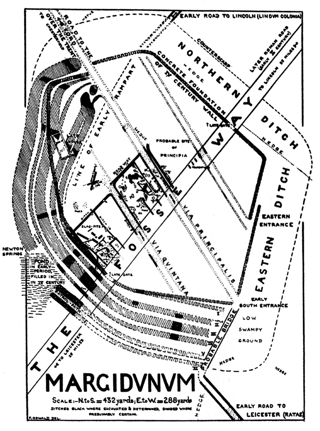
Margidunum

Margidunum was a Roman settlement on the Fosse Way at Castle Hill near present-day Bingham, in Nottinghamshire, England. The site is a protected Scheduled...
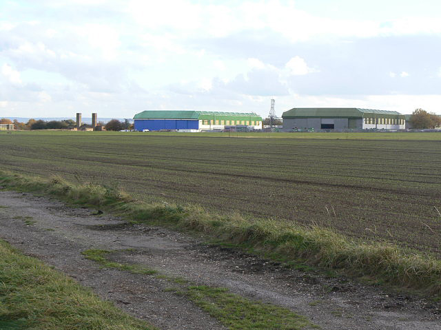
RAF Newton

Royal Air Force Newton or more simply RAF Newton (ICAO: EGXN) is a former Royal Air Force station located 7 miles (11 km) east of Nottingham, Nottinghamshire...

Saxondale, Nottinghamshire

Saxondale is a small hamlet and civil parish in the Rushcliffe borough of Nottinghamshire, England, situated just off the A52 road near to its junction...

Nearby Amenities

Located within 500m of 52.962768,-0.972492
Bus Stop
Newton Gardens
Bus: yes
Naptan AtcoCode: 3300RU0177
Naptan Bearing: NE
Naptan CommonName: Newton Gardens
Naptan Crossing: Newton Gardens
Naptan Indicator: adj
Naptan NaptanCode: ntsadpgm
Naptan Street: Fosse Road
Naptan Verified: no
Public Transport: platform
Shelter: no
Source: naptan_import
Lat/Long: 52.9594836/-0.9674608
Barrier: lift_gate
Lat/Long: 52.9665866/-0.9763788
Old Name: Newton Gardens
Old Place: locality
Source: Bing
Lat/Long: 52.9604065/-0.9702309
Direction: S
Generator Method: photovoltaic
Generator Output Electricity: yes
Generator Solar Modules: 18
Generator Source: solar
Generator Type: solar_photovoltaic_panel
Location: roof
Power: generator
Lat/Long: 52.9635645/-0.9760631
Direction: S
Generator Method: photovoltaic
Generator Output Electricity: yes
Generator Solar Modules: 190
Generator Source: solar
Generator Type: solar_photovoltaic_panel
Location: roof
Power: generator
Lat/Long: 52.9626966/-0.9744925
Direction: S
Generator Method: photovoltaic
Generator Output Electricity: yes
Generator Solar Modules: 16
Generator Source: solar
Generator Type: solar_photovoltaic_panel
Location: roof
Power: generator
Lat/Long: 52.9659283/-0.9744523
Direction: S
Generator Method: photovoltaic
Generator Output Electricity: yes
Generator Solar Modules: 15
Generator Source: solar
Generator Type: solar_photovoltaic_panel
Location: roof
Power: generator
Lat/Long: 52.9640237/-0.973582
Direction: S
Generator Method: photovoltaic
Generator Output Electricity: yes
Generator Solar Modules: 16
Generator Source: solar
Generator Type: solar_photovoltaic_panel
Location: roof
Power: generator
Lat/Long: 52.9640385/-0.973761
Direction: 210
Generator Method: photovoltaic
Generator Output Electricity: yes
Generator Solar Modules: 16
Generator Source: solar
Generator Type: solar_photovoltaic_panel
Location: roof
Power: generator
Lat/Long: 52.9623093/-0.9749299
Redrow - Ash Holt at Newton Garden Village
Shop: property
Lat/Long: 52.9613634/-0.9747378
Crossing
Crossing: unmarked
Crossing Island: yes
Kerb: lowered
Supervised: no
Tactile Paving: yes
Lat/Long: 52.9603602/-0.9700655
Power: substation
Lat/Long: 52.9627863/-0.9765092
Crossing
Crossing: unmarked
Kerb: lowered
Tactile Paving: yes
Lat/Long: 52.9600432/-0.9678579
Crossing
Lat/Long: 52.9616275/-0.9739389
Barrier: yes
Lat/Long: 52.961324/-0.9733392
Traffic Calming: hump
Lat/Long: 52.9638913/-0.9761202
Traffic Calming: hump
Lat/Long: 52.9645262/-0.9759365
The data included in this document is from www.openstreetmap.org. The data is made available under ODbL.

Have you been to Ash Holt?

Leave your review of Ash Holt below (or comments, questions and feedback).