East Balgrochan

Settlement in Stirlingshire

Scotland

East Balgrochan

Small hill behind Upper Carleston 110m spot height behind the farm.
Small hill behind Upper Carleston Credit: Stephen Sweeney

East Balgrochan is a small village located in the county of Stirlingshire, Scotland. Situated approximately 8 miles northwest of the town of Stirling, East Balgrochan is nestled within the picturesque countryside of central Scotland. The village is positioned at the foot of the Campsie Fells, a range of hills that provide a stunning backdrop to the area.

With a population of around 200 residents, East Balgrochan exudes a peaceful and close-knit community atmosphere. The village primarily consists of traditional stone-built houses, many of which date back several centuries, giving the area a unique charm and character.

Despite its small size, East Balgrochan offers a range of amenities to its residents. A local primary school serves the village, ensuring children have access to education within the community. The village also boasts a local pub, providing a social hub for residents to gather and enjoy a drink or meal together.

The natural surroundings of East Balgrochan are a major draw for both residents and visitors alike. The Campsie Fells offer numerous opportunities for outdoor activities such as hiking, mountain biking, and wildlife spotting. The nearby Carron Valley Reservoir is a popular spot for fishing and water sports.

Overall, East Balgrochan provides a serene and idyllic setting for those seeking a quiet countryside lifestyle, with the added benefit of easy access to nearby towns and cities.

If you have any feedback on the listing, please let us know in the comments section below.

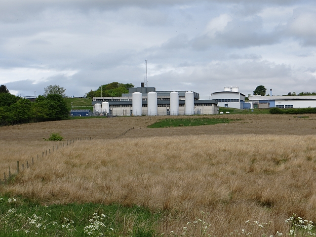
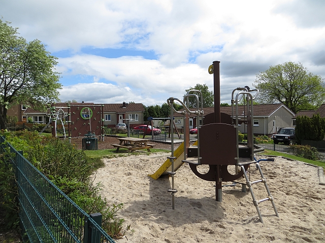
East Balgrochan Images

Images are sourced within 2km of 55.939179/-4.2109262 or Grid Reference NS6274. Thanks to Geograph Open Source API. All images are credited.

Small hill behind Upper Carleston 110m spot height behind the farm.
Small hill behind Upper Carleston
110m spot height behind the farm.
Torrance, Lennoxtown and the Campsie Fells from the air Torrance is at the bottom of the photo and Lennoxtown can be seen nestling at the foot of the Campsie Fells. The Crow Road can just be seen to the left of Lennoxtown. A wind farm is prominent on the horizon, with another less prominent wind farm is on the left horizon in the far distance.

Viewed from a flight from a thundery Gatwick <a href="https://www.geograph.org.uk/photo/2482228">TQ2640 : Thunderstorm over Gatwick Airport from the air</a> to Glasgow.
Torrance, Lennoxtown and the Campsie Fells from the air
Torrance is at the bottom of the photo and Lennoxtown can be seen nestling at the foot of the Campsie Fells. The Crow Road can just be seen to the left of Lennoxtown. A wind farm is prominent on the horizon, with another less prominent wind farm is on the left horizon in the far distance. Viewed from a flight from a thundery Gatwick TQ2640 : Thunderstorm over Gatwick Airport from the air to Glasgow.
HMP Low Moss from the air The prison closed in 2007 and a new, substantially larger medium security prison is being constructed on the same site. This was also the site of the Former RAF Bishopbriggs which was a barrage balloon depot.

See the same scene in May 2012 <a href="https://www.geograph.org.uk/photo/2965671">NS6272 : HMP Low Moss from the air</a>.
HMP Low Moss from the air
The prison closed in 2007 and a new, substantially larger medium security prison is being constructed on the same site. This was also the site of the Former RAF Bishopbriggs which was a barrage balloon depot. See the same scene in May 2012 NS6272 : HMP Low Moss from the air.
Torrance from the air The River Kelvin can be seen meandering under Torrance Bridge in the foreground. Viewed from a Glasgow bound flight from Luton.
Torrance from the air
The River Kelvin can be seen meandering under Torrance Bridge in the foreground. Viewed from a Glasgow bound flight from Luton.
Balmore water works from the air The recently upgraded works to the north of Glasgow. Viewed from a Glasgow bound flight from Luton.
Balmore water works from the air
The recently upgraded works to the north of Glasgow. Viewed from a Glasgow bound flight from Luton.
Forth and Clyde Canal The towpath, a cycle route, near a bridge at Cadder.
Forth and Clyde Canal
The towpath, a cycle route, near a bridge at Cadder.
Forth and Clyde Canal The towpath is a popular cycle path.
Forth and Clyde Canal
The towpath is a popular cycle path.
Forth and Clyde Canal View westwards towards Hungryside Bridge.
Forth and Clyde Canal
View westwards towards Hungryside Bridge.
Forth and Clyde Canal A landing stage at Easter Cadder.
Forth and Clyde Canal
A landing stage at Easter Cadder.
Arable land, Meiklehill A view across the Forth and Clyde Canal.
Arable land, Meiklehill
A view across the Forth and Clyde Canal.
Queensview An old road alignment in Torrance, now incorporated into a residential street.
Queensview
An old road alignment in Torrance, now incorporated into a residential street.
Queensview, Torrance
Holstein heifers Grassland between Torrance and Balmore.
Holstein heifers
Grassland between Torrance and Balmore.
Waterworks, Balmore A very large water treatment works, presumably serving Glasgow. Part of the site was once occupied by a colliery.
Waterworks, Balmore
A very large water treatment works, presumably serving Glasgow. Part of the site was once occupied by a colliery.
A807, Balmore Approaching the village, the water works are off shot to the right.
A807, Balmore
Approaching the village, the water works are off shot to the right.
Playground, Croft Road Park in a loop of Croft Road.
Playground, Croft Road
Park in a loop of Croft Road.
Back o' Waterworks Usual dumper attack on a back road.
Back o' Waterworks
Usual dumper attack on a back road.
Damp  pasture, Barraston
Damp pasture, Barraston
Show me another place!

East Balgrochan is located at Grid Ref: NS6274 (Lat: 55.939179, Lng: -4.2109262)

Unitary Authority: East Dunbartonshire

Police Authority: Greater Glasgow

What 3 Words

///reveal.crowds.hulk. Near Torrance, East Dunbartonshire

Related Wikis

Torrance railway station

Torrance railway station was opened in 1879 on the Kelvin Valley Railway and served the area of the village of Torrance in East Dunbartonshire until 1951...

Torrance, East Dunbartonshire

Torrance is a relatively affluent village in East Dunbartonshire, formerly Stirlingshire, Scotland, located eight miles (thirteen kilometres) north of...

East Dunbartonshire

East Dunbartonshire (Scots: Aest Dunbartanshire; Scottish Gaelic: Siorrachd Dhùn Bhreatann an Ear, pronounced [ˈʃirˠəxk ɣum ˈpɾʲɛht̪ən̪ˠ əɲ ˈɛɾ]) is one...

Balmore

Balmore (from the Scottish Gaelic "Baile Mòr" meaning a large settlement) is a small village formerly in the county of Stirlingshire, but now lies in East...

Nearby Amenities

Located within 500m of 55.939179,-4.2109262
Traffic Signals
Traffic Signals: signal
Traffic Signals Direction: forward
Lat/Long: 55.940695/-4.2112253
Torrance
Name En: Torrance
Name Gd: Torranan
Place: village
Wikidata: Q1907087
Wikipedia: en:Torrance, East Dunbartonshire
Lat/Long: 55.9397848/-4.2113894
Crossing
Crossing: traffic_signals
Crossing Island: no
Crossing Ref: pelican
Tactile Paving: yes
Lat/Long: 55.9354752/-4.2108421
Post Box
Lat/Long: 55.9419664/-4.2062936
Turning Circle
Source: Bing
Lat/Long: 55.938939/-4.2097338
Traffic Signals
Traffic Signals: signal
Traffic Signals Direction: backward
Lat/Long: 55.9404549/-4.2110522
Post Box
Lat/Long: 55.9431174/-4.2137124
Noexit: yes
Lat/Long: 55.9396842/-4.2106189
Bus Stop
Lat/Long: 55.9420563/-4.2060922
Bus Stop
Lat/Long: 55.9419827/-4.2059769
Traffic Signals
Traffic Signals Direction: backward
Lat/Long: 55.9406492/-4.2108934
Torrance War Memorial
Historic: memorial
Lat/Long: 55.9397685/-4.2114886
Bus Stop
Bus: yes
Naptan AtcoCode: 6110170
Naptan NaptanCode: 65423768
Public Transport: platform
Lat/Long: 55.9399762/-4.2110511
Post Office
Lat/Long: 55.9386333/-4.2117086
Townhall
Caldwell Halls
Lat/Long: 55.9406676/-4.2102857
Eclipse hair and beauty
Disused Shop: yes
Lat/Long: 55.940509/-4.2108746
Traffic Signals
Traffic Signals: signal
Traffic Signals Direction: backward
Lat/Long: 55.9405679/-4.2111071
Torrance
Historic Railway: station
Railway: site
Wikidata: Q64216409
Wikipedia: en:Torrance railway station
Lat/Long: 55.9398541/-4.2123788
Power: pole
Lat/Long: 55.94278/-4.2070705
Power: pole
Lat/Long: 55.9427296/-4.2070894
Give Way
Direction: forward
Lat/Long: 55.9361199/-4.2125719
Give Way
Direction: forward
Lat/Long: 55.9363915/-4.2127207
Give Way
Direction: forward
Lat/Long: 55.9362864/-4.2130422
The data included in this document is from www.openstreetmap.org. The data is made available under ODbL.

Have you been to East Balgrochan?

Leave your review of East Balgrochan below (or comments, questions and feedback).