Durrington

Settlement in Sussex Worthing

England

Durrington

Border of the Southdown National Park Footpath next to a Hill Barn Golf Club.

Park info : <span class="nowrap"><a title="https://en.wikipedia.org/wiki/South_Downs_National_Park" rel="nofollow ugc noopener" href="https://en.wikipedia.org/wiki/South_Downs_National_Park">Link</a><img style="margin-left:2px;" alt="External link" title="External link - shift click to open in new window" src="https://s1.geograph.org.uk/img/external.png" width="10" height="10"/></span>
Border of the Southdown National Park Credit: James Emmans

Durrington is a small village located in the district of Sussex, England. Situated just a few miles northwest of the city of Worthing, Durrington is part of the larger Worthing urban area. The village lies on the A27 road, providing convenient access to nearby towns and cities.

With a population of around 6,000 residents, Durrington offers a peaceful and friendly community atmosphere. The village is known for its picturesque countryside, featuring rolling hills and charming farmland. It is surrounded by beautiful natural landscapes, including the South Downs National Park, which is just a short distance away.

Durrington has a rich history, dating back to the Iron Age when it was originally settled. The village is home to several ancient landmarks, such as the Cissbury Ring, an Iron Age hill fort that is now a popular spot for walkers and hikers. Additionally, the nearby Stone Age flint mines at Church Hill are of archaeological importance and attract visitors interested in prehistoric sites.

The village boasts a range of amenities, including local shops, pubs, and a primary school, making it an attractive place for families. The nearby town of Worthing offers a wider range of services, including shopping centers, leisure facilities, and a hospital.

Overall, Durrington offers a tranquil and scenic environment, combined with convenient access to larger towns and cities, making it an appealing place to live or visit for those seeking a balance between rural charm and urban amenities.

If you have any feedback on the listing, please let us know in the comments section below.
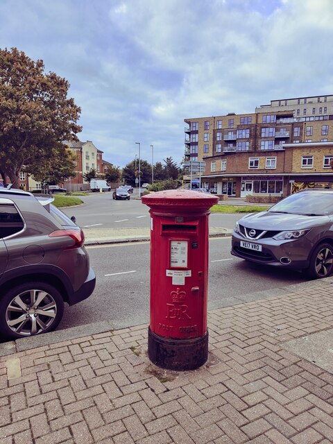
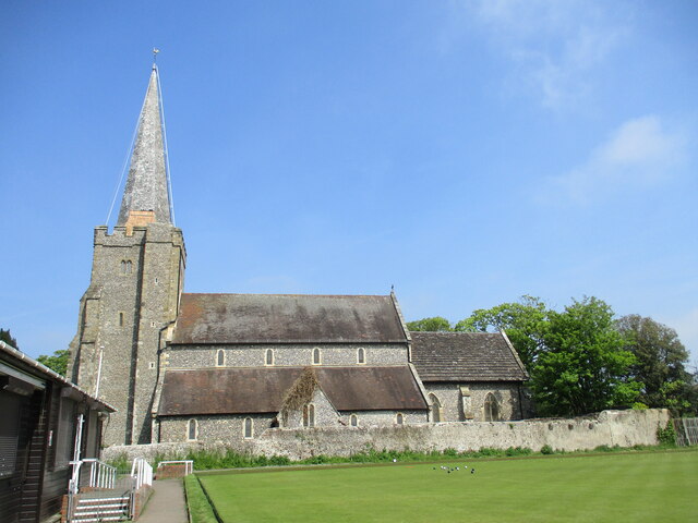
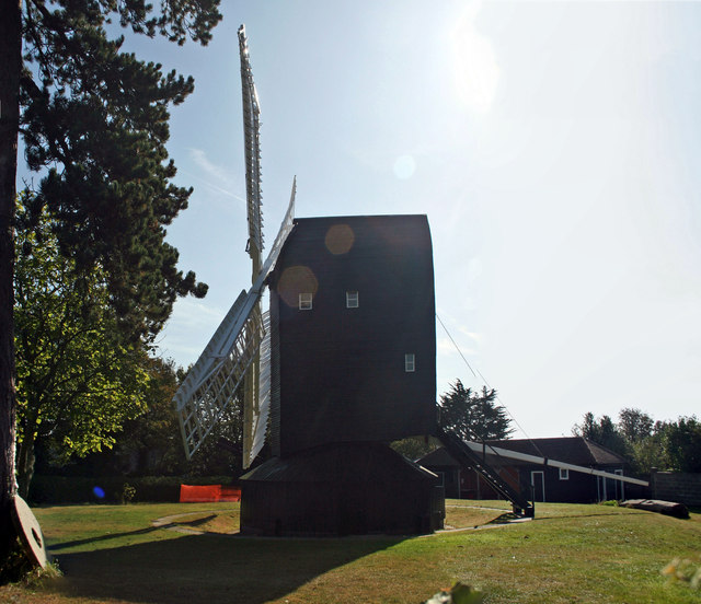
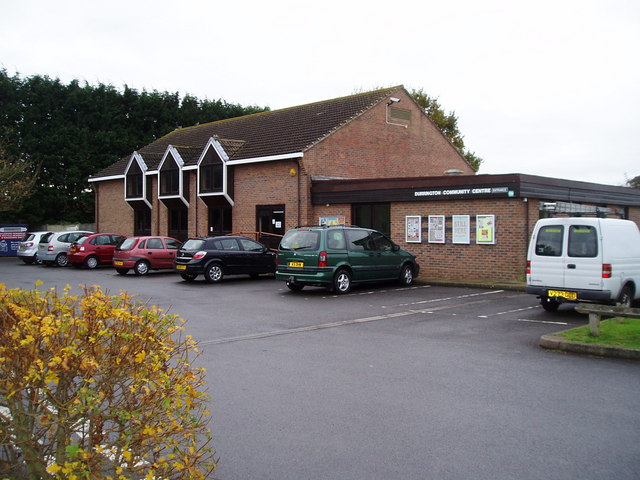
Durrington Images

Images are sourced within 2km of 50.834679/-0.414567 or Grid Reference TQ1105. Thanks to Geograph Open Source API. All images are credited.

Border of the Southdown National Park Footpath next to a Hill Barn Golf Club.

Park info : <span class="nowrap"><a title="https://en.wikipedia.org/wiki/South_Downs_National_Park" rel="nofollow ugc noopener" href="https://en.wikipedia.org/wiki/South_Downs_National_Park">Link</a><img style="margin-left:2px;" alt="External link" title="External link - shift click to open in new window" src="https://s1.geograph.org.uk/img/external.png" width="10" height="10"/></span>
Border of the Southdown National Park
Footpath next to a Hill Barn Golf Club. Park info : LinkExternal link
Lavington Road Detached 1930's houses, with new attic rooms.
Lavington Road
Detached 1930's houses, with new attic rooms.
Church Road, West Worthing Church Road is a residential road in West Worthing.
Church Road, West Worthing
Church Road is a residential road in West Worthing.
Church Road, West Worthing Church Road is a residential road in West Worthing.
Church Road, West Worthing
Church Road is a residential road in West Worthing.
Bellview Road, West Worthing Bellview Road is a residential road in West Worthing.
Bellview Road, West Worthing
Bellview Road is a residential road in West Worthing.
Pelham Road, West Worthing Pelham Road is a residential road in West Worthing.
Pelham Road, West Worthing
Pelham Road is a residential road in West Worthing.
Terringes Avenue, West Worthing Terringes Avenue is a residential road in West Worthing.
Terringes Avenue, West Worthing
Terringes Avenue is a residential road in West Worthing.
High Street, Tarring, near Worthing High Street in Tarring, in the suburbs of Worthing.
High Street, Tarring, near Worthing
High Street in Tarring, in the suburbs of Worthing.
Old School House, Tarring, near Worthing The name "Old School House" indicates that this building was originally a school.
Old School House, Tarring, near Worthing
The name "Old School House" indicates that this building was originally a school.
Lavington Road, Worthing Lavington Road is a residential road in Worthing.
Lavington Road, Worthing
Lavington Road is a residential road in Worthing.
Broomfield Avenue, Worthing Broomfield Avenue is a residential road in the suburbs of Worthing.
Broomfield Avenue, Worthing
Broomfield Avenue is a residential road in the suburbs of Worthing.
Postbox The Strand
Postbox The Strand
St  Andrew's  Parish  Church  from  bowling  green  edge Although there was a church here prior to this being built in the 13th century there is no trace of Saxon or Norman work in this church
St Andrew's Parish Church from bowling green edge
Although there was a church here prior to this being built in the 13th century there is no trace of Saxon or Norman work in this church
High  Street  from  Church  Road  junction
High Street from Church Road junction
The  tower  of  St  Andrew's  West  Tarring
The tower of St Andrew's West Tarring
Bishop's  Palace  13th  century  now  village  hall The Archbishops of Canterbury owned small manor houses for accommodation for their periodical progresses through the land. This is one still surviving
Bishop's Palace 13th century now village hall
The Archbishops of Canterbury owned small manor houses for accommodation for their periodical progresses through the land. This is one still surviving
Bishop's  Palace  13th  century  which  is  now  the  village  hall In 1872 it became a National School, on the 30th April 1958 it was purchased by the Parochial Church Council for use as the village hall
Bishop's Palace 13th century which is now the village hall
In 1872 it became a National School, on the 30th April 1958 it was purchased by the Parochial Church Council for use as the village hall
High Salvington post mill, Furze Road, Worthing Previously known as Durrington Mill this Grade II Listed post mill is described in the listing as having a fantail but no evidence exists to support this. The earliest written record of a mill in this location is in 1615 but the current mill was built around 1750. The windmill ground flour until 1897 and continued grinding animal feed until 1905. In 1907 the roundhouse was replaced with a concrete tea-room surviving well into the 1950s. Under the care of Worthing Borough Council who bought it for £2,250 in 1959 the mill was renovated in 1961. In 1965 the cottage and outbuildings were demolished. Gale damage in 1976 resulted in the formation of the High Salvington Mill Trust and a program to fully restore the mill. The new 58ft (17.6m) diameter sails were installed in 1987-8 and the new roundhouse built in 1990 before the mill started grinding flour again in 1991. In 1998 a split was discovered in one of the stocks and a new one was made and the sails refitted.
High Salvington post mill, Furze Road, Worthing
Previously known as Durrington Mill this Grade II Listed post mill is described in the listing as having a fantail but no evidence exists to support this. The earliest written record of a mill in this location is in 1615 but the current mill was built around 1750. The windmill ground flour until 1897 and continued grinding animal feed until 1905. In 1907 the roundhouse was replaced with a concrete tea-room surviving well into the 1950s. Under the care of Worthing Borough Council who bought it for £2,250 in 1959 the mill was renovated in 1961. In 1965 the cottage and outbuildings were demolished. Gale damage in 1976 resulted in the formation of the High Salvington Mill Trust and a program to fully restore the mill. The new 58ft (17.6m) diameter sails were installed in 1987-8 and the new roundhouse built in 1990 before the mill started grinding flour again in 1991. In 1998 a split was discovered in one of the stocks and a new one was made and the sails refitted.
Show me another place!

Durrington is located at Grid Ref: TQ1105 (Lat: 50.834679, Lng: -0.414567)

Administrative County: West Sussex

District: Worthing

Police Authority: Sussex

What 3 Words

///tasty.probing.botanists. Near Goring-by-Sea, West Sussex

Nearby Locations

Durrington Cote

Related Wikis

Durrington, West Sussex

Durrington is a neighbourhood of Worthing and former civil parish, now in the borough of Worthing in West Sussex, England. Historically in Sussex, in the...

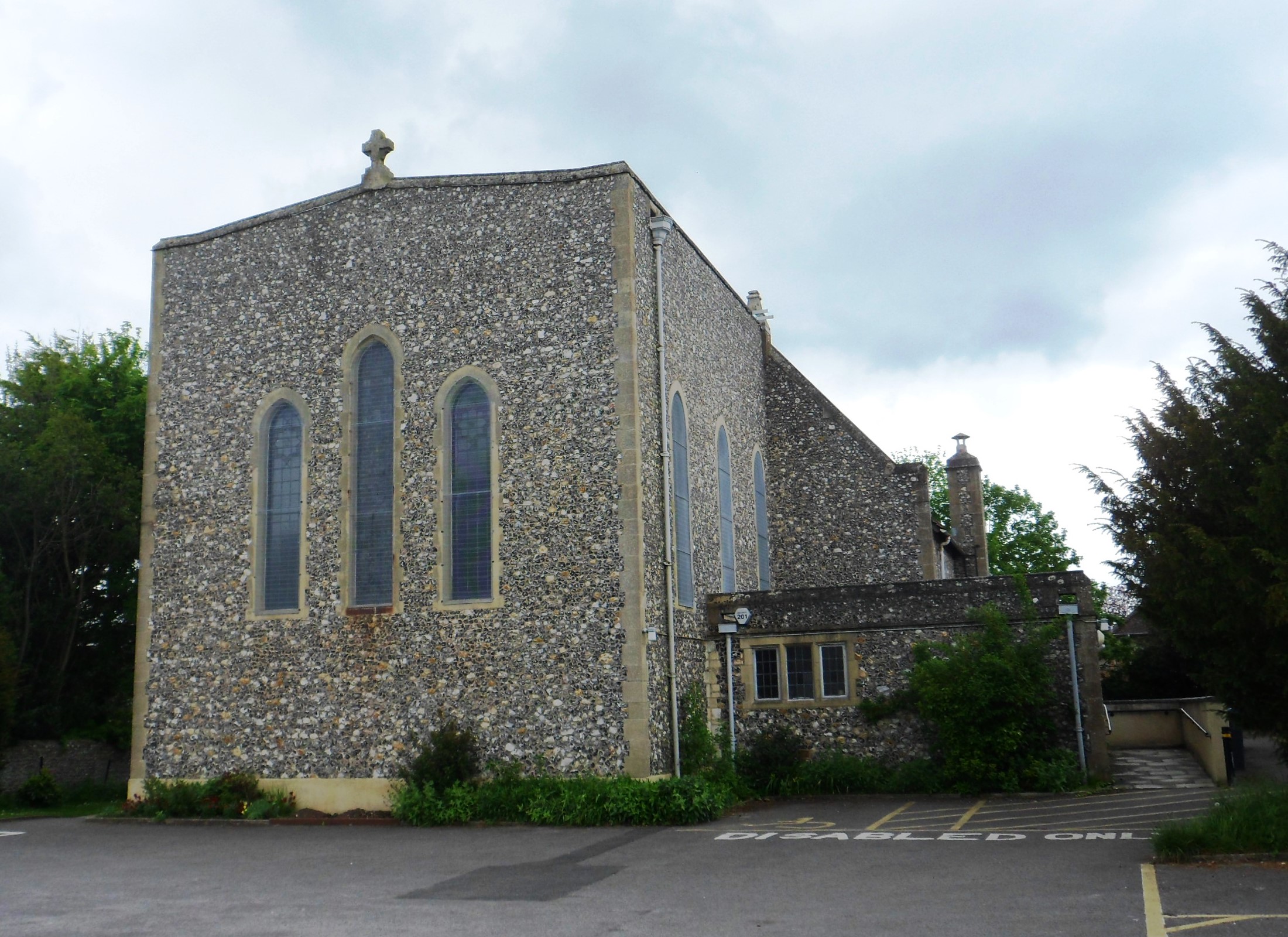
St Symphorian's Church, Durrington

St Symphorian's Church is an Anglican church in the Durrington area of the borough of Worthing, one of seven local government districts in the English...

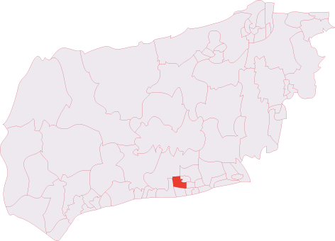
Durrington & Salvington (electoral division)

Durrington & Salvington is an electoral division of West Sussex in England, and returns one member to sit on West Sussex County Council. == Extent == The...

Oak Grove College

Oak Grove College is a coeducational special school and sixth form maintained by West Sussex County Council. The school provides special education for...

Cote, West Sussex

Cote (also Walcote or Coate) was a hamlet in the former parish of Durrington, West Sussex (now a suburb of Worthing), England. It is 3.25 miles (5.23 km...

RAF Durrington

RAF Durrington was a World War II ground-controlled interception (GCI) radar station in Durrington, West Sussex, a neighbourhood in Worthing in the United...

Palatine School

Palatine School (formerly George Pringle School or Selden County Junior Mixed and Infant School) is a primary school in Worthing, West Sussex for those...

Northbrook (electoral division)

Northbrook is an electoral division of West Sussex in the United Kingdom, and returns one member to sit on West Sussex County Council. == Extent == The...

Nearby Amenities

Located within 500m of 50.834679,-0.414567
Durrington
Is In: Worthing, West Sussex, England, UK
Place: suburb
Source: npe
Wikidata: Q640271
Lat/Long: 50.8328041/-0.4116659
Turning Circle
Lat/Long: 50.8337214/-0.4132243
Bus Stop
Torridge Close
Naptan AtcoCode: 4400WO0015
Naptan Bearing: N
Naptan CommonName: Torridge Close
Naptan Indicator: opp
Naptan Landmark: Torridge Close
Naptan NaptanCode: wsxdmjdj
Naptan ShortCommonName: Torridge Close
Naptan Street: New Road
Naptan Verified: no
Source: naptan_import
Lat/Long: 50.8339185/-0.4214855
Bus Stop
Torridge Close
Naptan AtcoCode: 4400WO0016
Naptan Bearing: S
Naptan CommonName: Torridge Close
Naptan Indicator: adj
Naptan Landmark: Torridge Close
Naptan NaptanCode: wsxdmjdm
Naptan ShortCommonName: Torridge Close
Naptan Street: New Road
Naptan Verified: no
Source: naptan_import
Lat/Long: 50.8337358/-0.4212786
Bus Stop
New Road
Naptan AtcoCode: 4400WO0017
Naptan Bearing: E
Naptan CommonName: New Road
Naptan Indicator: adj Mersey Road
Naptan Landmark: Mersey Road
Naptan NaptanCode: wsxdmjdp
Naptan Street: New Road
Naptan Verified: no
Source: naptan_import
Lat/Long: 50.8356543/-0.4194954
Bus Stop
Arun Crescent
Naptan AtcoCode: 4400WO0018
Naptan Bearing: W
Naptan CommonName: Arun Crescent
Naptan Indicator: adj
Naptan Landmark: Arun Crescent
Naptan NaptanCode: wsxdmjdt
Naptan ShortCommonName: Arun Crescent
Naptan Street: New Road
Naptan Verified: no
Source: naptan_import
Lat/Long: 50.8355928/-0.4189436
Bus Stop
Thames Way
Naptan AtcoCode: 4400WO0019
Naptan Bearing: N
Naptan CommonName: Thames Way
Naptan Indicator: opp
Naptan Landmark: Thames Way
Naptan NaptanCode: wsxdmjdw
Naptan ShortCommonName: Thames Way
Naptan Street: Adur Avenue
Naptan Verified: no
Source: naptan_import
Lat/Long: 50.8377207/-0.417352
Bus Stop
Thames Way
Naptan AtcoCode: 4400WO0020
Naptan Bearing: S
Naptan CommonName: Thames Way
Naptan Indicator: adj
Naptan Landmark: Thames Way
Naptan NaptanCode: wsxdmjga
Naptan ShortCommonName: Thames Way
Naptan Street: Adur Avenue
Naptan Verified: no
Source: naptan_import
Lat/Long: 50.8377354/-0.4171101
Bus Stop
Humber Close
Naptan AtcoCode: 4400WO0025
Naptan Bearing: SE
Naptan CommonName: Humber Close
Naptan Indicator: opp
Naptan Landmark: Humber Close
Naptan NaptanCode: wsxdmjgt
Naptan ShortCommonName: Humber Close
Naptan Street: Humber Avenue
Naptan Verified: no
Source: naptan_import
Lat/Long: 50.8358453/-0.4209802
Bus Stop
Humber Close
Naptan AtcoCode: 4400WO0026
Naptan Bearing: NW
Naptan CommonName: Humber Close
Naptan Indicator: adj
Naptan Landmark: Humber Close
Naptan NaptanCode: wsxdmjgw
Naptan ShortCommonName: Humber Close
Naptan Street: Humber Avenue
Naptan Verified: no
Source: naptan_import
Lat/Long: 50.8353443/-0.4205142
Bus Stop
Adur Avenue
Naptan AtcoCode: 4400WO0027
Naptan Bearing: E
Naptan CommonName: Adur Avenue
Naptan Indicator: adj
Naptan Landmark: Adur Avenue
Naptan NaptanCode: wsxdmjma
Naptan ShortCommonName: Adur Avenue
Naptan Street: New Road
Naptan Verified: no
Shelter: no
Source: naptan_import
Lat/Long: 50.8358722/-0.4163352
Bus Stop
Ivydore Avenue
Naptan AtcoCode: 4400WO0028
Naptan Bearing: W
Naptan CommonName: Ivydore Avenue
Naptan Indicator: opp
Naptan Landmark: Ivydore Avenue
Naptan NaptanCode: wsxdmjmd
Naptan ShortCommonName: Ivydore Avenue
Naptan Street: New Road
Naptan Verified: no
Shelter: no
Source: naptan_import
Lat/Long: 50.8357147/-0.4153322
Bus Stop
Ivydore Avenue
Bench: no
Bin: no
Naptan AtcoCode: 4400WO0029
Naptan Bearing: E
Naptan CommonName: Ivydore Avenue
Naptan Indicator: adj
Naptan Landmark: Ivydore Avenue
Naptan NaptanCode: wsxdmjmg
Naptan ShortCommonName: Ivydore Avenue
Naptan Street: New Road
Naptan Verified: no
Shelter: no
Source: naptan_import
Lat/Long: 50.835845/-0.4143336
Bus Stop
Lamb Inn
Naptan AtcoCode: 4400WO0030
Naptan Bearing: W
Naptan CommonName: Lamb Inn
Naptan Indicator: adj
Naptan Landmark: Manor Parade
Naptan NaptanCode: wsxdmjmj
Naptan ShortCommonName: Lamb Inn
Naptan Street: Salvington Road
Naptan Verified: no
Source: naptan_import
Lat/Long: 50.8356745/-0.411712
Bus Stop
Lamb Inn
Naptan AtcoCode: 4400WO0031
Naptan Bearing: E
Naptan CommonName: Lamb Inn
Naptan Indicator: opp Manor Parade
Naptan Landmark: Manor Parade
Naptan NaptanCode: wsxdmjmp
Naptan Street: Salvington Road
Naptan Verified: no
Source: naptan_import
Lat/Long: 50.8358026/-0.4112105
Bus Stop
Mendip Road
Naptan AtcoCode: 4400WO0050
Naptan Bearing: S
Naptan CommonName: Mendip Road
Naptan Indicator: adj
Naptan Landmark: Salvington Road
Naptan NaptanCode: wsxdmjwg
Naptan ShortCommonName: Mendip Road
Naptan Street: Exmoor Drive
Naptan Verified: no
Source: naptan_import
Lat/Long: 50.8360416/-0.408291
Bus Stop
Mendip Road
Naptan AtcoCode: 4400WO0051
Naptan Bearing: N
Naptan CommonName: Mendip Road
Naptan Indicator: opp
Naptan Landmark: Salvington Road
Naptan NaptanCode: wsxdmjwj
Naptan ShortCommonName: Mendip Road
Naptan Street: Exmoor Drive
Naptan Verified: no
Source: naptan_import
Lat/Long: 50.8360986/-0.4085163
Bus Stop
Pond Lane
Naptan AtcoCode: 4400WO0052
Naptan Bearing: S
Naptan CommonName: Pond Lane
Naptan Indicator: opp
Naptan Landmark: Salvington Lane
Naptan NaptanCode: wsxdmjwm
Naptan ShortCommonName: Pond Lane
Naptan Street: Durrington Lane
Naptan Verified: no
Source: naptan_import
Lat/Long: 50.8350795/-0.4122718
Bus Stop
Pond Lane
Naptan AtcoCode: 4400WO0053
Naptan Bearing: N
Naptan CommonName: Pond Lane
Naptan Indicator: adj
Naptan Landmark: Salvington Road
Naptan NaptanCode: wsxdmjwp
Naptan ShortCommonName: Pond Lane
Naptan Street: Durrington Lane
Naptan Verified: no
Shelter: yes
Source: naptan_import
Lat/Long: 50.8352091/-0.4125373
Bus Stop
Birkdale Road
Naptan AtcoCode: 4400WO0054
Naptan Bearing: N
Naptan CommonName: Birkdale Road
Naptan Indicator: adj
Naptan Landmark: Birkdale Road
Naptan NaptanCode: wsxdmjwt
Naptan ShortCommonName: Birkdale Road
Naptan Street: Durrington Lane
Naptan Verified: no
Source: naptan_import
Lat/Long: 50.8332711/-0.4122196
Bus Stop
Birkdale Road
Naptan AtcoCode: 4400WO0055
Naptan Bearing: S
Naptan CommonName: Birkdale Road
Naptan Indicator: opp
Naptan Landmark: Birkdale Road
Naptan NaptanCode: wsxdmpad
Naptan ShortCommonName: Birkdale Road
Naptan Street: Durrington Lane
Naptan Verified: no
Source: naptan_import
Lat/Long: 50.8328174/-0.4119226
Bus Stop
Health Centre
Bench: no
Bin: no
Lit: yes
Naptan AtcoCode: 4400WO0056
Naptan Bearing: N
Naptan CommonName: Health Centre
Naptan Indicator: o/s Health Centre
Naptan Landmark: Burnham Road
Naptan NaptanCode: wsxdmpag
Naptan Street: Durrington Lane
Naptan Verified: no
Shelter: no
Source: naptan_import
Tactile Paving: no
Lat/Long: 50.8312573/-0.4122737
Bus Stop
Health Centre
Naptan AtcoCode: 4400WO0057
Naptan Bearing: S
Naptan CommonName: Health Centre
Naptan Indicator: opp Health Centre
Naptan Landmark: Sunningdale Road
Naptan NaptanCode: wsxdmpaj
Naptan Street: Durrington Lane
Naptan Verified: no
Source: naptan_import
Lat/Long: 50.830516/-0.4122074
Bus Stop
Ivydore Avenue
Bench: no
Bin: no
Naptan AtcoCode: 4400WO0443
Naptan Bearing: N
Naptan CommonName: Ivydore Avenue
Naptan Indicator: Bramble Close
Naptan Landmark: opp. Bramble Close
Naptan NaptanCode: wsxdpmwd
Naptan Street: Ivydore Avenue
Naptan Verified: no
Shelter: no
Source: naptan_import
Lat/Long: 50.8369717/-0.415176
Noexit: yes
Lat/Long: 50.8303692/-0.4162842
Post Box
Brand: Royal Mail
Brand Wikidata: Q638098
Brand Wikipedia: en:Royal Mail
Collection Plate: CP1
Collection Times: Mo-Fr 17:15; Sa 12:00
Operator: Royal Mail
Operator Wikidata: Q638098
Post Box Type: pillar
Ref: BN13 1754
Royal Cypher: EIIR
Royal Cypher Wikidata: Q33102113
Lat/Long: 50.8356747/-0.410835
Post Box
Brand: Royal Mail
Brand Wikidata: Q638098
Brand Wikipedia: en:Royal Mail
Collection Plate: CP1D
Collection Times: Mo-Fr 09:00; Sa 07:00
Operator: Royal Mail
Operator Wikidata: Q638098
Post Box Type: pillar
Ref: BN13 1755D
Royal Cypher: GVIR
Royal Cypher Wikidata: Q33102169
Lat/Long: 50.8353884/-0.4204589
Post Box
Brand: Royal Mail
Brand Wikidata: Q638098
Brand Wikipedia: en:Royal Mail
Collection Plate: CP1
Collection Times: Mo-Fr 16:00; Sa 11:45
Operator: Royal Mail
Operator Wikidata: Q638098
Post Box Type: pillar
Ref: BN13 1756
Royal Cypher: EIIR
Royal Cypher Wikidata: Q33102113
Lat/Long: 50.8377083/-0.4150375
Generator Method: photovoltaic
Generator Output Electricity: yes
Generator Source: solar
Generator Type: solar_photovoltaic_panel
Location: roof
Power: generator
Lat/Long: 50.8388031/-0.4127839
Generator Method: photovoltaic
Generator Output Electricity: yes
Generator Source: solar
Generator Type: solar_photovoltaic_panel
Location: roof
Power: generator
Lat/Long: 50.8388353/-0.4141814
Generator Method: photovoltaic
Generator Output Electricity: yes
Generator Source: solar
Generator Type: solar_photovoltaic_panel
Location: roof
Power: generator
Lat/Long: 50.8386702/-0.4160036
Generator Method: photovoltaic
Generator Output Electricity: yes
Generator Source: solar
Generator Type: solar_photovoltaic_panel
Location: roof
Power: generator
Lat/Long: 50.8389406/-0.4164886
Generator Method: photovoltaic
Generator Output Electricity: yes
Generator Source: solar
Generator Type: solar_photovoltaic_panel
Location: roof
Power: generator
Lat/Long: 50.8374003/-0.4159723
Generator Method: photovoltaic
Generator Output Electricity: yes
Generator Source: solar
Generator Type: solar_photovoltaic_panel
Location: roof
Power: generator
Lat/Long: 50.8373973/-0.4158641
Generator Method: photovoltaic
Generator Output Electricity: yes
Generator Source: solar
Generator Type: solar_photovoltaic_panel
Location: roof
Power: generator
Lat/Long: 50.8377326/-0.4157478
Generator Method: photovoltaic
Generator Output Electricity: yes
Generator Source: solar
Generator Type: solar_photovoltaic_panel
Location: roof
Power: generator
Lat/Long: 50.8383356/-0.4145917
Generator Method: photovoltaic
Generator Output Electricity: yes
Generator Source: solar
Generator Type: solar_photovoltaic_panel
Location: roof
Power: generator
Lat/Long: 50.8374446/-0.4153088
Generator Method: photovoltaic
Generator Output Electricity: yes
Generator Source: solar
Generator Type: solar_photovoltaic_panel
Location: roof
Power: generator
Lat/Long: 50.8369045/-0.4169585
Generator Method: photovoltaic
Generator Output Electricity: yes
Generator Source: solar
Generator Type: solar_photovoltaic_panel
Location: roof
Power: generator
Lat/Long: 50.836693/-0.4163776
Generator Method: photovoltaic
Generator Output Electricity: yes
Generator Source: solar
Generator Type: solar_photovoltaic_panel
Location: roof
Power: generator
Lat/Long: 50.8364205/-0.416168
Generator Method: photovoltaic
Generator Output Electricity: yes
Generator Source: solar
Generator Type: solar_photovoltaic_panel
Location: roof
Power: generator
Lat/Long: 50.8359894/-0.4175431
Generator Method: photovoltaic
Generator Output Electricity: yes
Generator Source: solar
Generator Type: solar_photovoltaic_panel
Location: roof
Power: generator
Lat/Long: 50.8367155/-0.4189739
Generator Method: photovoltaic
Generator Output Electricity: yes
Generator Source: solar
Generator Type: solar_photovoltaic_panel
Location: roof
Power: generator
Lat/Long: 50.8355228/-0.4185281
Generator Method: photovoltaic
Generator Output Electricity: yes
Generator Source: solar
Generator Type: solar_photovoltaic_panel
Location: roof
Power: generator
Lat/Long: 50.8355513/-0.4183683
Generator Method: photovoltaic
Generator Output Electricity: yes
Generator Source: solar
Generator Type: solar_photovoltaic_panel
Location: roof
Power: generator
Lat/Long: 50.8356458/-0.4177047
Generator Method: photovoltaic
Generator Output Electricity: yes
Generator Source: solar
Generator Type: solar_photovoltaic_panel
Location: roof
Power: generator
Lat/Long: 50.8356431/-0.4174423
Generator Method: photovoltaic
Generator Output Electricity: yes
Generator Source: solar
Generator Type: solar_photovoltaic_panel
Location: roof
Power: generator
Lat/Long: 50.834667/-0.417229
Generator Method: photovoltaic
Generator Output Electricity: yes
Generator Source: solar
Generator Type: solar_photovoltaic_panel
Location: roof
Power: generator
Lat/Long: 50.8346844/-0.4174835
Generator Method: photovoltaic
Generator Output Electricity: yes
Generator Source: solar
Generator Type: solar_photovoltaic_panel
Location: roof
Power: generator
Lat/Long: 50.83477/-0.4199588
Generator Method: photovoltaic
Generator Output Electricity: yes
Generator Source: solar
Generator Type: solar_photovoltaic_panel
Location: roof
Power: generator
Lat/Long: 50.8331316/-0.4140524
Generator Method: photovoltaic
Generator Output Electricity: yes
Generator Source: solar
Generator Type: solar_photovoltaic_panel
Location: roof
Power: generator
Lat/Long: 50.8329315/-0.414173
Generator Method: photovoltaic
Generator Output Electricity: yes
Generator Source: solar
Generator Type: solar_photovoltaic_panel
Location: roof
Power: generator
Lat/Long: 50.8329236/-0.4142986
Generator Method: photovoltaic
Generator Output Electricity: yes
Generator Source: solar
Generator Type: solar_photovoltaic_panel
Location: roof
Power: generator
Lat/Long: 50.8325966/-0.4143584
Generator Method: photovoltaic
Generator Output Electricity: yes
Generator Source: solar
Generator Type: solar_photovoltaic_panel
Location: roof
Power: generator
Lat/Long: 50.8325662/-0.4146527
Generator Method: photovoltaic
Generator Output Electricity: yes
Generator Source: solar
Generator Type: solar_photovoltaic_panel
Location: roof
Power: generator
Lat/Long: 50.8321615/-0.4152218
Generator Method: photovoltaic
Generator Output Electricity: yes
Generator Source: solar
Generator Type: solar_photovoltaic_panel
Location: roof
Power: generator
Lat/Long: 50.832529/-0.4150463
Generator Method: photovoltaic
Generator Output Electricity: yes
Generator Source: solar
Generator Type: solar_photovoltaic_panel
Location: roof
Power: generator
Lat/Long: 50.8328938/-0.4145013
Generator Method: photovoltaic
Generator Output Electricity: yes
Generator Source: solar
Generator Type: solar_photovoltaic_panel
Location: roof
Power: generator
Lat/Long: 50.8328021/-0.4153724
Generator Method: photovoltaic
Generator Output Electricity: yes
Generator Source: solar
Generator Type: solar_photovoltaic_panel
Location: roof
Power: generator
Lat/Long: 50.8326838/-0.4168755
Generator Method: photovoltaic
Generator Output Electricity: yes
Generator Source: solar
Generator Type: solar_photovoltaic_panel
Location: roof
Power: generator
Lat/Long: 50.8328947/-0.4202271
Generator Method: photovoltaic
Generator Output Electricity: yes
Generator Source: solar
Generator Type: solar_photovoltaic_panel
Location: roof
Power: generator
Lat/Long: 50.8338421/-0.4210372
Generator Method: photovoltaic
Generator Output Electricity: yes
Generator Source: solar
Generator Type: solar_photovoltaic_panel
Location: roof
Power: generator
Lat/Long: 50.8309143/-0.4174617
Generator Method: photovoltaic
Generator Output Electricity: yes
Generator Source: solar
Generator Type: solar_photovoltaic_panel
Location: roof
Power: generator
Lat/Long: 50.8310037/-0.4135613
Crossing
Crossing: traffic_signals
Crossing Markings: dots
Crossing Ref: puffin
Tactile Paving: yes
Lat/Long: 50.8305564/-0.4122334
The data included in this document is from www.openstreetmap.org. The data is made available under ODbL.

Have you been to Durrington?

Leave your review of Durrington below (or comments, questions and feedback).