Dunsby

Settlement in Lincolnshire South Kesteven

England

Dunsby

Rippingale village - map and historical information Completed for the millennium
Rippingale village - map and historical information Credit: Tony and Maureen Kemp

Dunsby is a small village located in the South Kesteven district of Lincolnshire, England. Situated about 9 miles north of the market town of Bourne, Dunsby is nestled in the picturesque countryside of the East Midlands. The village is part of the civil parish of Dunsby cum Birthorpe, which encompasses both Dunsby and the neighboring hamlet of Birthorpe.

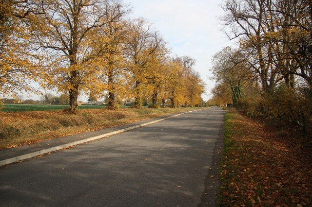
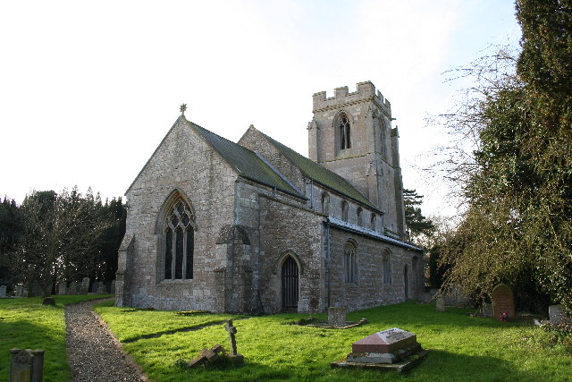
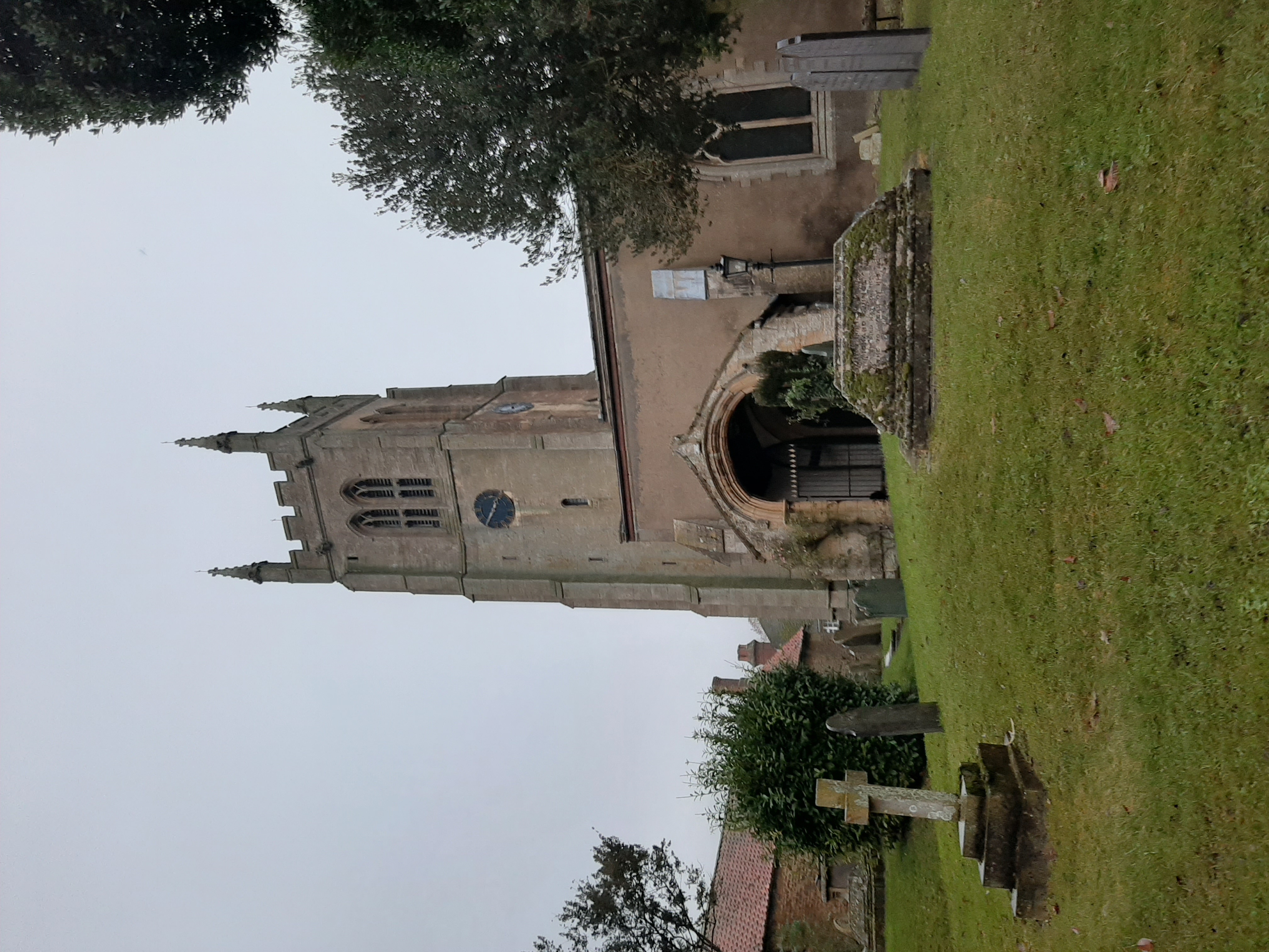
Dunsby retains a charming and tranquil atmosphere with its quaint rural setting. The village is characterized by its traditional stone-built houses, many of which date back to the 18th and 19th centuries. These properties, along with the nearby St. Mary and All Saints Church, contribute to the village's historic appeal.

While Dunsby is primarily a residential area, it offers a range of amenities to its residents. These include a village hall, which serves as a hub for community events and gatherings, and a playground for children. The village is also home to a few small businesses, including a local pub that provides a friendly meeting place for both locals and visitors.

The surrounding countryside provides ample opportunities for outdoor activities, with scenic walks and cycling routes available in the area. Dunsby is also conveniently located near several nature reserves, such as Bourne Woods and Willow Tree Fen, which offer diverse wildlife and beautiful landscapes.

Overall, Dunsby offers a peaceful and idyllic setting for those seeking a rural lifestyle in Lincolnshire. Its rich history, natural surroundings, and close-knit community make it an attractive place to live or visit.

If you have any feedback on the listing, please let us know in the comments section below.

Dunsby Images

Images are sourced within 2km of 52.828083/-0.360036 or Grid Reference TF1026. Thanks to Geograph Open Source API. All images are credited.

Rippingale village - map and historical information Completed for the millennium
Rippingale village - map and historical information
Completed for the millennium
St.Andrew's church, Rippingale, Lincs. A grand Perpendicular tower of St.Andrew's is a prominent landmark in this part of Lincolnshire, the church is a curious nave and chancel in one with a six bay arcade of c1300
St.Andrew's church, Rippingale, Lincs.
A grand Perpendicular tower of St.Andrew's is a prominent landmark in this part of Lincolnshire, the church is a curious nave and chancel in one with a six bay arcade of c1300
Farmland east of Kirkby Underwood, Lincs looking S from the Rippingale Road across the Old Beck valley.
Farmland east of Kirkby Underwood, Lincs
looking S from the Rippingale Road across the Old Beck valley.
St Andrew's Church and the Bull Inn, Rippingale
Public footpath Looking towards Dunsby from the stile on the A15. Standing in the shadow of Dunsby Wood on a bright January afternoon.
Public footpath
Looking towards Dunsby from the stile on the A15. Standing in the shadow of Dunsby Wood on a bright January afternoon.
Looking towards Bourne on the A15 Dunsby Wood on the right.
Looking towards Bourne on the A15
Dunsby Wood on the right.
Dunsby Wood This large mixed woodland is part of a string of woodland across this part of Lincolnshire. It is commercially managed for timber and this section is mainly oak. Taken from the public bridleway.
Dunsby Wood
This large mixed woodland is part of a string of woodland across this part of Lincolnshire. It is commercially managed for timber and this section is mainly oak. Taken from the public bridleway.
Farmland at Rippingale Looking up the gently rising ground to the south west of the village.
Farmland at Rippingale
Looking up the gently rising ground to the south west of the village.
Farmland at Rippingale Looking towards Graby from Station Road.
Farmland at Rippingale
Looking towards Graby from Station Road.
In the shadow of Dunsby Wood The low January afternoon sun casts long shadows from the trees. The houses on the horizon are at Littleworth Barn in <a href="https://www.geograph.org.uk/gridref/TF0828">TF0828</a>.
In the shadow of Dunsby Wood
The low January afternoon sun casts long shadows from the trees. The houses on the horizon are at Littleworth Barn in TF0828.
St Andrew's Church, Rippingale
The Bull, Rippingale
Autumn on High Street Autumnal view on Rippingale High Street
Autumn on High Street
Autumnal view on Rippingale High Street
Autumn on High Street Looking west along the road to Kirkby Underwood
Autumn on High Street
Looking west along the road to Kirkby Underwood
Entering Rippingale Entering the village from the A15.
Entering Rippingale
Entering the village from the A15.
Village sign for Rippingale The first reference to Rippingale is found in the Anglo-Saxon chronicle of 675.  The name is perhaps a combination of three Celtic words Ri (upper), Apen (water) and Cal (forest)  The village does stand on ground between the fens and the forest.
Village sign for Rippingale
The first reference to Rippingale is found in the Anglo-Saxon chronicle of 675. The name is perhaps a combination of three Celtic words Ri (upper), Apen (water) and Cal (forest) The village does stand on ground between the fens and the forest.
Entering Rippingale Horses and riders entering the village from the west.
Entering Rippingale
Horses and riders entering the village from the west.
War Memorial, Rippingale The war memorial stands on an area of raised ground within the churchyard.  It is built of limestone and designed by Reginald Blomfield.

We will remember them.
War Memorial, Rippingale
The war memorial stands on an area of raised ground within the churchyard. It is built of limestone and designed by Reginald Blomfield. We will remember them.
Show me another place!

Dunsby is located at Grid Ref: TF1026 (Lat: 52.828083, Lng: -0.360036)

Division: Parts of Kesteven

Administrative County: Lincolnshire

District: South Kesteven

Police Authority: Lincolnshire

What 3 Words

///double.swan.expensive. Near Bourne, Lincolnshire

Nearby Locations

Dunsby

Related Wikis

Dunsby

Dunsby is a small village and civil parish in the South Kesteven district of in Lincolnshire, England. It is 4 miles (6.4 km) north from Bourne, just east...

Rippingale

Rippingale is a village and civil parish in the South Kesteven district of Lincolnshire, England. The population of the civil parish was 929 at the 2011...

St Andrew's Church, Rippingale

The Church of St Andrew in Rippingale, Lincolnshire, England, is a Grade Iā€“listed Anglican church. The earliest phase of the church dates back to the mid...

Rippingale railway station

Rippingale railway station was a station serving the villages of Rippingale, Dowsby and Dunsby, Lincolnshire on the Great Northern Railway Bourne and Sleaford...

Nearby Amenities

Located within 500m of 52.828083,-0.360036
Dunsby
Is In: Lincolnshire, England, UK
Place: village
Lat/Long: 52.8279012/-0.3593942
Bus Stop
Bus Shelter
Bus: yes
Naptan AtcoCode: 270000008725
Naptan Bearing: N
Naptan BusStopType: CUS
Naptan CommonName: Bus Shelter
Naptan Indicator: opp
Naptan Landmark: Bus Shelter
Naptan NaptanCode: lingtptm
Naptan Street: Doctor's Lane
Naptan Verified: no
Public Transport: platform
Source: naptan_import
Lat/Long: 52.8276343/-0.3641992
Bus Stop
Bus Shelter
Bus: yes
Naptan AtcoCode: 270000008726
Naptan Bearing: S
Naptan CommonName: Bus Shelter
Naptan Indicator: adj
Naptan Landmark: Bus Shelter
Naptan NaptanCode: lingtptp
Naptan Street: Doctor's Lane
Naptan Verified: no
Public Transport: platform
Source: naptan_import
Lat/Long: 52.827614/-0.3640367
Bus Stop
Telephone Box
Bus: yes
Naptan AtcoCode: 270000008727
Naptan Bearing: N
Naptan CommonName: Telephone Box
Naptan Indicator: adj
Naptan Landmark: Telephone Box
Naptan NaptanCode: lingtptw
Naptan Street: Main Road
Naptan Verified: no
Public Transport: platform
Source: naptan_import
Lat/Long: 52.8288797/-0.3599813
Bus Stop
Telephone Box
Bus: yes
Naptan AtcoCode: 270000008728
Naptan Bearing: S
Naptan CommonName: Telephone Box
Naptan Indicator: opp
Naptan Landmark: Telephone Box
Naptan NaptanCode: lingtpwa
Naptan Street: Main Road
Naptan Verified: no
Public Transport: platform
Source: naptan_import
Lat/Long: 52.8287868/-0.3597622
North End Farm
Place: farm
Source: Bing
Lat/Long: 52.8297866/-0.3589248
Entrance: yes
Lat/Long: 52.8282402/-0.3595417
Power: pole
Lat/Long: 52.824668/-0.3644469
Power: pole
Lat/Long: 52.8255386/-0.3640055
Power: pole
Lat/Long: 52.8265337/-0.3634565
Power: pole
Lat/Long: 52.8274341/-0.3629591
Power: pole
Lat/Long: 52.8283818/-0.3624773
Power: pole
Lat/Long: 52.8292868/-0.3621783
Power: pole
Lat/Long: 52.8303076/-0.3618422
Power: pole
Lat/Long: 52.8311874/-0.3615575
Power: pole
Lat/Long: 52.8318364/-0.3613294
Power: pole
Lat/Long: 52.8298276/-0.3619617
Defibrillator
Access: yes
Defibrillator Location: outside Dunsby Village Hall
Emergency: defibrillator
Indoor: no
Lat/Long: 52.8282825/-0.3595445
The data included in this document is from www.openstreetmap.org. The data is made available under ODbL.

Have you been to Dunsby?

Leave your review of Dunsby below (or comments, questions and feedback).