High Wood

Wood, Forest in Berkshire

England

High Wood

Bucklebury Farm footpath A public footpath crossing Bucklebury Farm. The route of the path is a little confusing across the attraction itself.

If approaching from the north, you cross the car park after crossing the field near Pease Hill, follow the pedestrian entrance to the park, then walk through the "exit" gate to the right (west) of the admissions building. You then climb or open and close three metal gates to fields, and walk on the left (east) side of the fence in this field until you reach two stiles. Cross these and then follow the fenceline until you reach a gate and exit to the restricted byway.

If approaching from the south, you go through the metal gate from the restricted byway, follow the fenceline to a pair of stiles, cross both and follow the fenceline down to a series of three gates. Open and close or climb over these three through fields until you reach the exit gate. Go through the gate and follow the pedestrian walk to the car park and continue to the metal gate crossing a field beside the entrance driveway.

Shoutout to the kind gentleman who helped me with the route on my walk!
Bucklebury Farm footpath Credit: Oscar Taylor

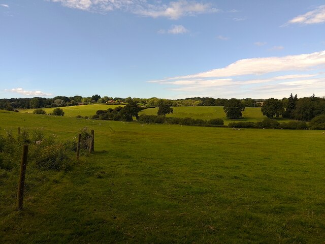
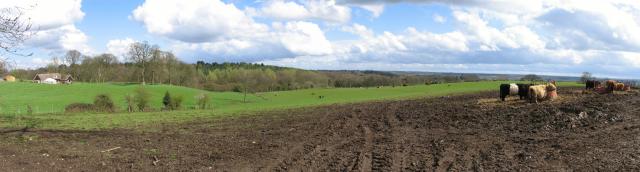
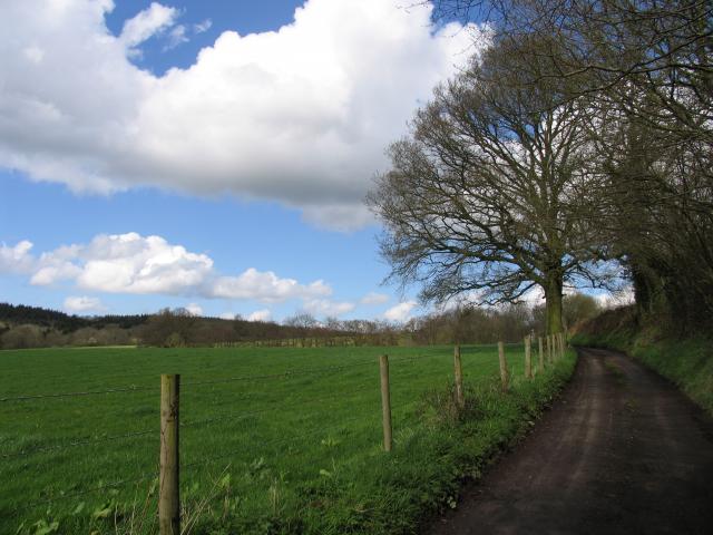
High Wood is a small woodland located in Berkshire, England. Situated in the southeastern part of the county, it is surrounded by the picturesque countryside and is part of the larger forest area in the region. The wood is named after its elevated position, which offers stunning views of the surrounding landscape.

Covering an area of approximately 50 hectares, High Wood is predominantly composed of native broadleaf trees such as oak, beech, and ash. These trees, along with the dense undergrowth, create a diverse and vibrant ecosystem that supports a wide variety of flora and fauna.

The woodland is a popular destination for nature enthusiasts and walkers, with several well-maintained footpaths and trails meandering through its enchanting landscape. Visitors can explore the wood's many hidden treasures, including ancient trees, wildflowers, and tranquil ponds. The serene atmosphere and abundant wildlife make it an ideal spot for birdwatching, as numerous species can be observed throughout the year.

High Wood has a rich history, with evidence of human habitation dating back to prehistoric times. The wood has been managed sustainably for centuries, providing timber and other natural resources to the local community. Today, it is protected as a nature reserve, ensuring the preservation of its unique ecological features.

Overall, High Wood offers a peaceful and idyllic escape from the hustle and bustle of urban life. Its natural beauty, biodiversity, and cultural significance make it a cherished part of Berkshire's landscape.

If you have any feedback on the listing, please let us know in the comments section below.

High Wood Images

Images are sourced within 2km of 51.409081/-1.2047222 or Grid Reference SU5568. Thanks to Geograph Open Source API. All images are credited.

Bucklebury Farm footpath A public footpath crossing Bucklebury Farm. The route of the path is a little confusing across the attraction itself.

If approaching from the north, you cross the car park after crossing the field near Pease Hill, follow the pedestrian entrance to the park, then walk through the "exit" gate to the right (west) of the admissions building. You then climb or open and close three metal gates to fields, and walk on the left (east) side of the fence in this field until you reach two stiles. Cross these and then follow the fenceline until you reach a gate and exit to the restricted byway.

If approaching from the south, you go through the metal gate from the restricted byway, follow the fenceline to a pair of stiles, cross both and follow the fenceline down to a series of three gates. Open and close or climb over these three through fields until you reach the exit gate. Go through the gate and follow the pedestrian walk to the car park and continue to the metal gate crossing a field beside the entrance driveway.

Shoutout to the kind gentleman who helped me with the route on my walk!
Bucklebury Farm footpath
A public footpath crossing Bucklebury Farm. The route of the path is a little confusing across the attraction itself. If approaching from the north, you cross the car park after crossing the field near Pease Hill, follow the pedestrian entrance to the park, then walk through the "exit" gate to the right (west) of the admissions building. You then climb or open and close three metal gates to fields, and walk on the left (east) side of the fence in this field until you reach two stiles. Cross these and then follow the fenceline until you reach a gate and exit to the restricted byway. If approaching from the south, you go through the metal gate from the restricted byway, follow the fenceline to a pair of stiles, cross both and follow the fenceline down to a series of three gates. Open and close or climb over these three through fields until you reach the exit gate. Go through the gate and follow the pedestrian walk to the car park and continue to the metal gate crossing a field beside the entrance driveway. Shoutout to the kind gentleman who helped me with the route on my walk!
Bucklebury landscape A field of sheep near to Redhill Copse.
Bucklebury landscape
A field of sheep near to Redhill Copse.
Bucklebury field
Bucklebury field
Midgham Green This was taken looking south over farmland. The square consists largely of farmland. There are also large detached residences in this square and two minor roads.
Midgham Green
This was taken looking south over farmland. The square consists largely of farmland. There are also large detached residences in this square and two minor roads.
Horn's Copse: East of Bucklebury Common and South of Carbin's wood Taken from the road looking north, this wood is situated north of Midgham Green. Most of this square is woodland, there being three named woodland areas, Carbins Wood, Horns Copse and Channel Wood. They are a mixture of coniferous and non coniferous trees. This copse is predominantly non coniferous.
Horn's Copse: East of Bucklebury Common and South of Carbin's wood
Taken from the road looking north, this wood is situated north of Midgham Green. Most of this square is woodland, there being three named woodland areas, Carbins Wood, Horns Copse and Channel Wood. They are a mixture of coniferous and non coniferous trees. This copse is predominantly non coniferous.
St Matthew's Midgham The Church is at the top of the hill and is situated at the bottom of the square. The photo was taken from the A4 (Bath Road) in the next grid square below the one where the Church is.
St Matthew's Midgham
The Church is at the top of the hill and is situated at the bottom of the square. The photo was taken from the A4 (Bath Road) in the next grid square below the one where the Church is.
St Matthew's Parish Midgham The Church is east of the road leading Northwards from the A4. It is in the lower part of the square. The Community of Midgham is mentioned in the Domesday Book.
St Matthew's Parish Midgham
The Church is east of the road leading Northwards from the A4. It is in the lower part of the square. The Community of Midgham is mentioned in the Domesday Book.
Midgham Lock: Kennet and Avon Canal West Berks The picture was taken from the west side of the lock, looking east, with the road bridge in the background.
Midgham Lock: Kennet and Avon Canal West Berks
The picture was taken from the west side of the lock, looking east, with the road bridge in the background.
Bath Road: Midgham The pub (The Coach and Horses) is at the junction of the road to Midgham and Brimpton, on the A4. The road to Midgham is just visible in the picture.
Bath Road: Midgham
The pub (The Coach and Horses) is at the junction of the road to Midgham and Brimpton, on the A4. The road to Midgham is just visible in the picture.
Kennet and Avon Canal: West of Midgham Lock This photograph was taken from the lock, looking towards Thatcham and Newbury.
Kennet and Avon Canal: West of Midgham Lock
This photograph was taken from the lock, looking towards Thatcham and Newbury.
Kennet and Avon Canal: Midgham This picture was taken from the bridge, looking towards Woolhampton (east).
Kennet and Avon Canal: Midgham
This picture was taken from the bridge, looking towards Woolhampton (east).
Farmland in the Bucklebury/Midgham Area The view of the farmland in this photograph was taken from Kiln's Farm on the east side of Cox's Lane looking towards Midgham Wood, which is just visible. It is situated in the south eastern corner of the square.
Farmland in the Bucklebury/Midgham Area
The view of the farmland in this photograph was taken from Kiln's Farm on the east side of Cox's Lane looking towards Midgham Wood, which is just visible. It is situated in the south eastern corner of the square.
Ouzel Gulley and Manor Farm Taken from the west side of Cox's Lane overlooking Ouzel Gulley and Manor Farm, this view is situated in the centre and west side of the square.
Ouzel Gulley and Manor Farm
Taken from the west side of Cox's Lane overlooking Ouzel Gulley and Manor Farm, this view is situated in the centre and west side of the square.
Cox's Lane This is the spot from where the photo of Ouzel Gulley was taken (more or less at the number 101 on the grid) and the only passing place in this square!
Cox's Lane
This is the spot from where the photo of Ouzel Gulley was taken (more or less at the number 101 on the grid) and the only passing place in this square!
Oxlease Bridge: Kennet and Avon Canal The Bridge is situated to the west of Woolhampton Lock and the picture was taken from the east side of the bridge, looking west.
Oxlease Bridge: Kennet and Avon Canal
The Bridge is situated to the west of Woolhampton Lock and the picture was taken from the east side of the bridge, looking west.
Thatcham Looking west across the square in the direction of Siege Cross Farm. Most of the square is farmland. The distant buildings are part of the industrial estate beside the A4 road.
Thatcham
Looking west across the square in the direction of Siege Cross Farm. Most of the square is farmland. The distant buildings are part of the industrial estate beside the A4 road.
Thatcham Looking west towards Colthrop Manor
Thatcham
Looking west towards Colthrop Manor
Midgham in the Autumn This scene is just south of Midgham Green, in the centre of the square, where the lane comes into the road from the left.
Midgham in the Autumn
This scene is just south of Midgham Green, in the centre of the square, where the lane comes into the road from the left.
Show me another place!

High Wood is located at Grid Ref: SU5568 (Lat: 51.409081, Lng: -1.2047222)

Unitary Authority: West Berkshire

Police Authority: Thames Valley

What 3 Words

///chucked.behaving.buzzer. Near Thatcham, Berkshire

Related Wikis

Midgham

Midgham is a village and civil parish occupying slopes and the flood plain on the north side of the River Kennet, which in summer months draws much of...

Midgham Green

Midgham Green is a hamlet in the civil parish of Midgham in the English county of Berkshire. The settlement lies near to the A4 road and is located approximately...

Bucklebury Common

Bucklebury Common is an elevated common consisting of woodland with a few relatively small clearings in the English county of Berkshire, within the civil...

Colthrop

Colthrop is a suburb of the town of Thatcham in the English county of Berkshire, England. == Geography == Colthrop is part of the civil parish of Thatcham...

Heale's Lock

Heale's Lock is a lock on the Kennet and Avon Canal, between Thatcham and Woolhampton, Berkshire, England. Heale's Lock was built between 1718 and 1723...

Midgham Lock

Midgham Lock is a lock on the Kennet and Avon Canal, between Thatcham and Woolhampton, Berkshire, England. Midgham Lock was built between 1718 and 1723...

Bucklebury Manor

Bucklebury Manor is a Grade II listed manor house in the civil parish of Bucklebury in the English county of Berkshire. Since 2012, it has been the home...

Chapel Row

Chapel Row is a hamlet in West Berkshire, England, and part of the civil parish of Bucklebury. In 2019 it had an estimated population of 627. == History... ==

Nearby Amenities

Located within 500m of 51.409081,-1.2047222
Woodside Farm
Landuse: farmland
Lat/Long: 51.4056429/-1.2054539
The data included in this document is from www.openstreetmap.org. The data is made available under ODbL.

Have you been to High Wood?

Leave your review of High Wood below (or comments, questions and feedback).