Alcove Plantation

Wood, Forest in Yorkshire

England

Alcove Plantation

The Bird Scrape, North Anston This photograph was taken from the top of the reclaimed Dinnington colliery site. The bird scrape was the idea of the SK58 Birders Group, and there is now a hide close by to watch wading birds.
The Bird Scrape, North Anston Credit: Robin Stonebridge

Alcove Plantation is a serene and picturesque woodland located in the heart of Yorkshire, England. Nestled amidst the stunning natural beauty of the region, this enchanting forest is a haven for nature lovers and outdoor enthusiasts alike.

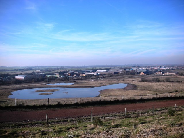
Covering an area of approximately 100 acres, Alcove Plantation is characterized by its dense woodland, towering ancient trees, and a diverse array of plant and animal species. The forest boasts a mix of deciduous and coniferous trees, including oak, beech, and pine, creating a rich and vibrant ecosystem. The forest floor is adorned with a carpet of moss, ferns, and wildflowers, adding to the enchanting ambiance.

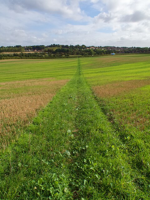
Visitors to Alcove Plantation can enjoy a range of activities, from leisurely walks along the well-maintained trails to birdwatching and wildlife spotting. The forest is home to a variety of bird species, such as woodpeckers, owls, and songbirds, making it a paradise for bird enthusiasts. Lucky visitors may also catch a glimpse of elusive woodland creatures, including deer, foxes, and squirrels.

Alcove Plantation offers a tranquil and peaceful escape from the hustle and bustle of everyday life. The serene atmosphere and breathtaking natural beauty make it an ideal destination for nature photography, meditation, or simply unwinding amidst the soothing sounds of nature.

Overall, Alcove Plantation in Yorkshire is a hidden gem, offering visitors a chance to immerse themselves in the beauty of nature and experience the tranquility of a pristine woodland environment.

If you have any feedback on the listing, please let us know in the comments section below.

Alcove Plantation Images

Images are sourced within 2km of 53.364299/-1.2159559 or Grid Reference SK5285. Thanks to Geograph Open Source API. All images are credited.

The Bird Scrape, North Anston This photograph was taken from the top of the reclaimed Dinnington colliery site. The bird scrape was the idea of the SK58 Birders Group, and there is now a hide close by to watch wading birds.
The Bird Scrape, North Anston
This photograph was taken from the top of the reclaimed Dinnington colliery site. The bird scrape was the idea of the SK58 Birders Group, and there is now a hide close by to watch wading birds.
The Loyal Trooper pub, car park and surrounding building
North Anston Methodist Church viewed from Chapel Rise. Houses on The Wells in the background
Church of St James Grade I listed parish church dating from the 14th century
Church of St James
Grade I listed parish church dating from the 14th century
Field path  Looking towards the A57 road
Field path
Looking towards the A57 road
Anston village boundary sign On the A57 to the west of the village
Anston village boundary sign
On the A57 to the west of the village
Public footpath On a hillside to the north of Anston Brook
Public footpath
On a hillside to the north of Anston Brook
Footbridge over Anston Brook
Drive to Bluebell Wood Children's Hospice Off Cramfit Road in North Anston
Drive to Bluebell Wood Children's Hospice
Off Cramfit Road in North Anston
Todwick Road Looking SW to the junction with Common Road
Todwick Road
Looking SW to the junction with Common Road
South Anston Methodist Community Hall A former Wesleyan Methodist Chapel.
South Anston Methodist Community Hall
A former Wesleyan Methodist Chapel.
Leeds Arms A community pub in the heart of the village.
Leeds Arms
A community pub in the heart of the village.
Buses for sale Former London Transport buses lined up in a dealer's yard in South Anston
Buses for sale
Former London Transport buses lined up in a dealer's yard in South Anston
Church of St James Grade I listed parish church dating from the 14th century
Church of St James
Grade I listed parish church dating from the 14th century
Ordnance Survey Cut Mark This OS cut mark can be found on the west face of St James Church. It marks a point 116.196m above mean sea level.
Ordnance Survey Cut Mark
This OS cut mark can be found on the west face of St James Church. It marks a point 116.196m above mean sea level.
The Tropical Butterfly House Wildlife & Falconry Centre Along Woodsetts Road in North Anston.
The Tropical Butterfly House Wildlife & Falconry Centre
Along Woodsetts Road in North Anston.
Woodsetts Road in North Anston
Ryton Road in South Anston
Show me another place!

Alcove Plantation is located at Grid Ref: SK5285 (Lat: 53.364299, Lng: -1.2159559)

Division: West Riding

Unitary Authority: Rotherham

Police Authority: South Yorkshire

What 3 Words

///lock.steepest.struts. Near Dinnington, South Yorkshire

Related Wikis

Dinnington Main Colliery

Dinnington Main Colliery was a coal mine situated in the village of Dinnington, near Rotherham, South Yorkshire, England. Until the coming of the colliery...

Dinnington Town F.C.

Dinnington Town Football Club is a football club based in Dinnington, Rotherham, South Yorkshire, England. == History == The club was formed in 2000, joining...

Dinnington, South Yorkshire

Dinnington is a town and civil parish in the Metropolitan Borough of Rotherham in South Yorkshire, England. It is near to the towns of Worksop and Rotherham...

Macalloy

McCalls Special Products Ltd is a British manufacturer of steel bar and cable components for tensioned concrete, ground anchors, curtain walling, and steel...

Anston

Anston is a civil parish in South Yorkshire, England, formally known as North and South Anston. The parish of Anston consists of the settlements of North...

Dinnington High School

Dinnington High School is a coeducational comprehensive school and Sixth Form in Dinnington, in the Metropolitan Borough of Rotherham, South Yorkshire...

Anston railway station

Anston railway station was situated on the Great Central and Midland Joint Railway line between the villages of North Anston and South Anston near Rotherham...

Beighton (ward)

Beighton ()—which includes the districts of Beighton, Hackenthorpe, Owlthorpe, and Sothall—is one of the 28 electoral wards in City of Sheffield, England...

Nearby Amenities

Located within 500m of 53.364299,-1.2159559
Mini Roundabout
Lat/Long: 53.3657294/-1.2092175
Bus Stop
Nursery Road/Park Avenue
Alt Name: Nursery Road/Park Avenue
Bus: yes
Naptan AltCommonName: Nursery Road/Park Avenue
Naptan AtcoCode: 370030053
Naptan Bearing: SW
Naptan CommonName: Nursery Road/Park Avenue
Naptan Indicator: 30053
Naptan Landmark: DINNINGTON PARK
Naptan PlusbusZoneRef: ROTHCEN
Naptan Street: Nursery Road
Naptan Verified: no
Public Transport: platform
Source: naptan_import
Lat/Long: 53.3632017/-1.2121009
Bus Stop
Nursery Road/Walnut Drive
Alt Name: Nursery Road/Walnut Drive
Bus: yes
Naptan AltCommonName: Nursery Road/Walnut Drive
Naptan AtcoCode: 370030054
Naptan Bearing: NE
Naptan CommonName: Nursery Road/Walnut Drive
Naptan Indicator: 30054
Naptan Landmark: DINNINGTON PARK
Naptan PlusbusZoneRef: ROTHCEN
Naptan Street: Nursery Road
Naptan Verified: no
Public Transport: platform
Source: naptan_import
Lat/Long: 53.3643789/-1.2106816
Bus Stop
New Road/Nursery Road
Alt Name: New Road/Nursery Road
Bus: yes
Naptan AltCommonName: New Road/Nursery Road
Naptan AtcoCode: 370030055
Naptan Bearing: SE
Naptan CommonName: New Road/Nursery Road
Naptan Indicator: 30055
Naptan Landmark: 30055
Naptan PlusbusZoneRef: ROTHCEN
Naptan Street: New Road
Naptan Verified: no
Public Transport: platform
Source: naptan_import
Lat/Long: 53.3659911/-1.2097951
Bus Stop
New Road/Nursery Road
Alt Name: New Road/Nursery Road
Bus: yes
Naptan AltCommonName: New Road/Nursery Road
Naptan AtcoCode: 370030056
Naptan Bearing: NW
Naptan CommonName: New Road/Nursery Road
Naptan Indicator: 30056
Naptan Landmark: 30056
Naptan PlusbusZoneRef: ROTHCEN
Naptan Street: New Road
Naptan Verified: no
Public Transport: platform
Source: naptan_import
Lat/Long: 53.3659942/-1.210276
Bus Stop
Nursery Road/Falcon Way
Bus: yes
Naptan AtcoCode: 370035194
Naptan Bearing: SW
Naptan CommonName: Nursery Road/Falcon Way
Naptan Indicator: 35194
Naptan Landmark: WILLIAMS BAR PUB
Naptan PlusbusZoneRef: ROTHCEN
Naptan Street: Nursery Road
Naptan Verified: no
Public Transport: platform
Source: naptan_import
Lat/Long: 53.3619493/-1.2143931
Bus Stop
Nursery Road/Falcon Way
Bus: yes
Naptan AtcoCode: 370035204
Naptan Bearing: NE
Naptan CommonName: Nursery Road/Falcon Way
Naptan Indicator: 35204
Naptan Landmark: Dinnington Park
Naptan PlusbusZoneRef: ROTHCEN
Naptan Street: Nursery Road
Naptan Verified: no
Public Transport: platform
Source: naptan_import
Lat/Long: 53.3625119/-1.2138267
Turning Circle
Lat/Long: 53.3664839/-1.2138023
Crossing
Lat/Long: 53.3664587/-1.2117334
Turning Circle
Lat/Long: 53.3643727/-1.2088945
Turning Circle
Lat/Long: 53.3648256/-1.2087416
Crossing
Lat/Long: 53.3623124/-1.21407
Bench
Lat/Long: 53.3640238/-1.2113064
Pub
The Little Mester
Addr City: Sheffield
Addr Country: GB
Addr Postcode: S25 4BZ
Addr Street: Nursery Road
Addr Suburb: North Anston
Brand: Greene King
Brand Wikidata: Q5564162
Fhrs Id: 460635
Website: https://www.greeneking.co.uk/pubs/south-yorkshire/little-mester
Lat/Long: 53.3622054/-1.2147918
Post Box
Collection Times: Mo-Fr 09:00; Sa 07:00
Post Box Type: pillar
Ref: S25 933
Royal Cypher: EIIR
Royal Cypher Wikidata: Q33102113
Lat/Long: 53.3622891/-1.2144301
Defibrillator
Access: yes
Check Date: 2023-03-09
Defibrillator Location: On outside wall. Available 24/7.
Emergency: defibrillator
Indoor: no
Opening Hours: 24/7
Lat/Long: 53.3661184/-1.2110152
Defibrillator
Access: yes
Check Date: 2023-03-09
Defibrillator Location: On outside wall. Available 24/7.
Emergency: defibrillator
Indoor: no
Opening Hours: 24/7
Ref GB The Circuit: FF28C2B6-C270-40B9-A19B-AD9B00F2D110
Lat/Long: 53.3609564/-1.2134607
Barrier: cycle_barrier
Lat/Long: 53.3622754/-1.2137558
Generator Method: photovoltaic
Generator Output Electricity: yes
Generator Source: solar
Generator Type: solar_photovoltaic_panel
Location: roof
Power: generator
Lat/Long: 53.363902/-1.2090513
Generator Method: photovoltaic
Generator Output Electricity: yes
Generator Source: solar
Generator Type: solar_photovoltaic_panel
Location: roof
Power: generator
Lat/Long: 53.3651073/-1.2091157
Generator Method: photovoltaic
Generator Output Electricity: yes
Generator Source: solar
Generator Type: solar_photovoltaic_panel
Location: roof
Power: generator
Lat/Long: 53.3651457/-1.2090111
Noexit: yes
Lat/Long: 53.3640754/-1.2155931
The data included in this document is from www.openstreetmap.org. The data is made available under ODbL.

Have you been to Alcove Plantation?

Leave your review of Alcove Plantation below (or comments, questions and feedback).