Holywell Wood

Wood, Forest in Leicestershire Charnwood

England

Holywell Wood

Houses on Ashby Road,  A512
Houses on Ashby Road, A512 Credit: Ian S

Holywell Wood is a picturesque woodland located in Leicestershire, England. Covering an area of approximately 120 acres, it is known for its natural beauty and diverse range of flora and fauna. The wood is situated near the village of Whitwick and is easily accessible to visitors.

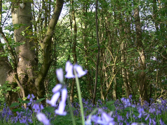
The wood features a mix of broadleaf trees, including oak, birch, and ash, which provide a rich canopy and create a tranquil atmosphere. The undergrowth is abundant with bluebells in the spring, creating a stunning display of color. Holywell Wood is also home to a variety of wildlife, including squirrels, rabbits, and a wide range of bird species.

The wood offers several walking trails that allow visitors to explore its natural wonders. These trails are well-maintained and suitable for all ages and fitness levels. Along the paths, visitors can expect to find benches and picnic spots, perfect for enjoying a quiet moment amidst nature.

Holywell Wood is managed by the Leicestershire County Council, ensuring its preservation and conservation. The wood is open to the public throughout the year, with no entrance fee required. It is a popular destination for nature enthusiasts, walkers, and families looking for a peaceful and scenic retreat.

In summary, Holywell Wood in Leicestershire is a charming woodland oasis, offering visitors the chance to immerse themselves in nature's beauty and serenity. With its diverse range of trees, wildlife, and well-maintained trails, it is a haven for those seeking a peaceful escape from the bustle of everyday life.

If you have any feedback on the listing, please let us know in the comments section below.

Holywell Wood Images

Images are sourced within 2km of 52.75909/-1.2501888 or Grid Reference SK5018. Thanks to Geograph Open Source API. All images are credited.

Houses on Ashby Road,  A512
Houses on Ashby Road, A512
J23 overbridges, M1 In very wet weather.
J23 overbridges, M1
In very wet weather.
The A512 west of Loughborough This main road links the town with the M1 motorway.
The A512 west of Loughborough
This main road links the town with the M1 motorway.
On Nanpantan Road, Nanpantan
Coach Road eastwards into Garendon Park See <a href="https://www.geograph.org.uk/photo/6557835">SK4919 : Sign on Coach Road</a> for sign.
Coach Road eastwards into Garendon Park
Temple of Venus, Garendon Park, Loughborough Considerable landscaping has taken place here in recent years. In the foreground of this view there was once a bridge carrying the Coalville - Loughborough railway line.
Temple of Venus, Garendon Park, Loughborough
Considerable landscaping has taken place here in recent years. In the foreground of this view there was once a bridge carrying the Coalville - Loughborough railway line.
Loncliffe Golf Club, Nanpantan Longcliffe Golf Club is set on the lower slopes of Charnwood Forest two and a half miles from the centre of Loughborough. The site is well forested with old and new Silver Birch, Oak, Pine, Beech, Gorse, and Broom.
Loncliffe Golf Club, Nanpantan
Longcliffe Golf Club is set on the lower slopes of Charnwood Forest two and a half miles from the centre of Loughborough. The site is well forested with old and new Silver Birch, Oak, Pine, Beech, Gorse, and Broom.
Footpath at Loncliffe Golf Club This mossy public footpath crosses the golf course on its way from Nanpantan to junction 23 on the M1. It is rather overgrown in places and there is easier walking alongside the trees to the right just on the edge of the fairways.
Footpath at Loncliffe Golf Club
This mossy public footpath crosses the golf course on its way from Nanpantan to junction 23 on the M1. It is rather overgrown in places and there is easier walking alongside the trees to the right just on the edge of the fairways.
Loncliffe Golf Club, Nanpantan Looking northwards from the public footpath. This shows the variety of trees on this attractive golf course, predominantly silver birch on this section.
Loncliffe Golf Club, Nanpantan
Looking northwards from the public footpath. This shows the variety of trees on this attractive golf course, predominantly silver birch on this section.
Golfers at Loncliffe Golf Club Looking across from the public footpath towards the woodland on Rhododendron Hill
Golfers at Loncliffe Golf Club
Looking across from the public footpath towards the woodland on Rhododendron Hill
Junction 23 North M1 motorway
View towards Loughborough Looking northeast from Nanpantan Road.
View towards Loughborough
Looking northeast from Nanpantan Road.
Dry stone wall along Nanpantan Road In the distance is the town of Loughborough, nestling in the Soar Valley.
Dry stone wall along Nanpantan Road
In the distance is the town of Loughborough, nestling in the Soar Valley.
Nanpantan Road enters the Borough of Charnwood
View across the Charnwood countryside Looking east from Nanpantan Road.
View across the Charnwood countryside
Looking east from Nanpantan Road.
Bluebells at Rhododendron Hill
Woodland and bluebells at Rhododendron Hill
Junction 23, M1 northbound
Show me another place!

Holywell Wood is located at Grid Ref: SK5018 (Lat: 52.75909, Lng: -1.2501888)

Administrative County: Leicestershire

District: Charnwood

Police Authority: Leicestershire

What 3 Words

///distracts.parts.juggled. Near Shepshed, Leicestershire

Related Wikis

Holywell Park Conference Centre

Holywell Park Conference Centre is modern conference facility located on Loughborough University Campus offering 300 m2 of exhibition space and accommodating...

Cenex

Cenex, the Low Carbon and Fuel Cells Centre of Excellence, is an independent non-profit research and consultancy that helps private and public sector organisations...

Loughborough University F.C.

Loughborough University Football Club (also known as Loughborough Students Football Club) is an English football club representing Loughborough University...

Engineering Subject Centre

The Engineering Subject Centre (EngSC) was one of 24 subject centres within the Higher Education Academy from 2000 to 2011. The academy encouraged, supported...

Burleigh Court Conference Centre and Hotel

Burleigh Court Conference Centre and Hotel is a four-star hotel and conference centre located on Loughborough University campus. Opened in April 1991...

Nanpantan

Nanpantan is a suburb of Loughborough, in the Charnwood borough of Leicestershire, England. It is located in the south-west of the town of Loughborough...

Snells Nook Halt railway station

Snells Nook Halt railway station was a station on the Charnwood Forest Railway. Near the village of Nanpantan, on the outskirts of Loughborough, Leicestershire...
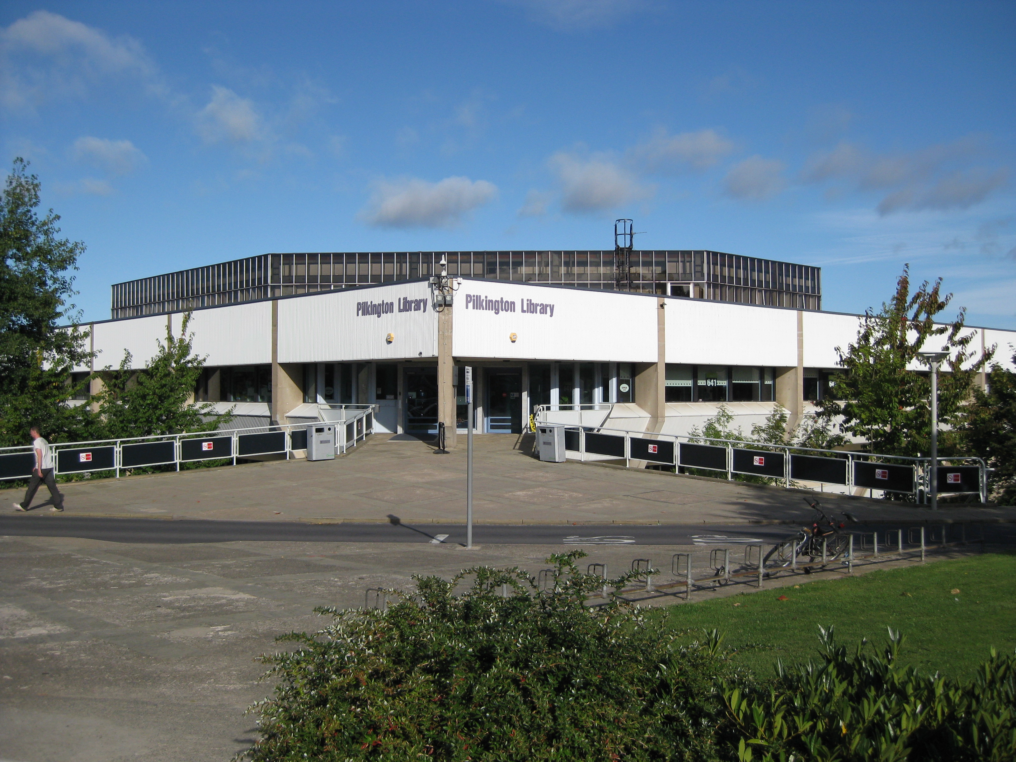
Pilkington Library

The Pilkington Library is the academic library at Loughborough University, situated in the West Park of the university campus at Loughborough, Leicestershire...

Nearby Amenities

Located within 500m of 52.75909,-1.2501888
Traffic Calming: choker
Lat/Long: 52.7624725/-1.2536508
Traffic Signals
Source: survey
Lat/Long: 52.7617059/-1.2540601
Kerb: raised
Lat/Long: 52.7610936/-1.2456787
Barrier: stile
Lat/Long: 52.7590777/-1.2568714
Barrier: block
Foot: yes
Motor Vehicle: no
Lat/Long: 52.7616873/-1.2530325
Fountain
Lat/Long: 52.7588424/-1.2448222
Fountain
Lat/Long: 52.7586202/-1.2451034
The Flame
Artist Name: Neil and Auriol Lawson Baker
Artwork Type: sculpture
Material: bronze
Tourism: artwork
Lat/Long: 52.7607526/-1.2441078
Access: private
Tourism: picnic_site
Lat/Long: 52.7591293/-1.2469778
Bus Stop
Wheatsheaf PH
Alt Name: Loughborough - New Ashby Road
Bus: yes
Naptan AltCommonName: Loughborough - New Ashby Road
Naptan AtcoCode: 260007228
Naptan Bearing: E
Naptan CommonName: Wheatsheaf PH
Naptan Indicator: outside
Naptan Landmark: Wheatsheaf PH
Naptan NaptanCode: leiadwmd
Naptan Notes: Hourly - County
Naptan Street: New Ashby Road
Naptan Verified: no
Public Transport: platform
Source: naptan_import
Lat/Long: 52.7623023/-1.2493397
Bus Stop
Wheatsheaf PH
Bus: yes
Naptan AtcoCode: 260007241
Naptan Bearing: W
Naptan CommonName: Wheatsheaf PH
Naptan Indicator: 30m before
Naptan Landmark: entrance to Wheatsheaf Public House
Naptan NaptanCode: leiadwjd
Naptan Notes: Hourly - County
Naptan Street: New Ashby Road
Naptan Verified: no
Public Transport: platform
Source: naptan_import
Lat/Long: 52.7618855/-1.2516662
Bus Stop
Pitsford Drive
Bus: yes
Naptan AtcoCode: 260007322
Naptan Bearing: NE
Naptan CommonName: Pitsford Drive
Naptan Indicator: adjacent
Naptan Landmark: Pitsford Drive
Naptan NaptanCode: leiagdjm
Naptan Notes: Hourly - County
Naptan Street: Old Ashby Road
Naptan Verified: no
Public Transport: platform
Source: naptan_import
Lat/Long: 52.7628832/-1.2530792
Bus Stop
Pitsford Drive
Bus: yes
Naptan AtcoCode: 260007331
Naptan Bearing: SW
Naptan CommonName: Pitsford Drive
Naptan Indicator: opposite
Naptan Landmark: Pitsford Drive
Naptan NaptanCode: leiagjpg
Naptan Notes: Hourly - County
Naptan Street: Old Ashby Road
Naptan Verified: no
Public Transport: platform
Source: naptan_import
Lat/Long: 52.7628462/-1.252902
Bus Stop
Holywell Park
Bench: yes
Bin: yes
Check Date Shelter: 2021-06-01
Lit: yes
Naptan AtcoCode: 260007431
Naptan Bearing: NW
Naptan CommonName: Holywell Park
Naptan Indicator: outside
Naptan Landmark: Gas Research Centre
Naptan NaptanCode: leiagwtm
Naptan Notes: Hourly - County
Naptan Street: Ashby Road
Naptan Verified: no
Public Transport: platform
Shelter: yes
Source: naptan_import
Tactile Paving: no
Lat/Long: 52.7600486/-1.2444558
Bicycle Parking
Bicycle Parking: stands
Capacity: 5
Covered: yes
Lat/Long: 52.7593103/-1.2482741
Cafe
Holywell Cafe
Access: private
Wheelchair: yes
Lat/Long: 52.7592024/-1.2467554
Crossing
Crossing: marked
Lat/Long: 52.760978/-1.2440192
Cafe
Energy @ SportPark
Lat/Long: 52.7619193/-1.245579
Barrier: lift_gate
Lat/Long: 52.7598511/-1.2460837
Crossing
Crossing: unmarked
Kerb: lowered
Source: survey
Tactile Paving: no
Lat/Long: 52.7625809/-1.2457815
Door G
Barrier: entrance
Lat/Long: 52.7593556/-1.2481869
Crossing
Crossing: unmarked
Kerb: lowered
Source: survey
Tactile Paving: no
Lat/Long: 52.7624681/-1.245703
Barrier: lift_gate
Source: Bing
Lat/Long: 52.7615401/-1.2463529
Entrance: main
Lat/Long: 52.7605103/-1.2431816
Crossing
Crossing: marked
Lat/Long: 52.758679/-1.2461956
Bench
Backrest: yes
Check Date: 2021-06-02
Source: Bing
Lat/Long: 52.7588115/-1.2453655
Entrance: yes
Lat/Long: 52.7595067/-1.2477309
Entrance: yes
Lat/Long: 52.7590829/-1.2464097
Entrance: yes
Lat/Long: 52.7591473/-1.2468089
Barrier: lift_gate
Lat/Long: 52.7617494/-1.2479049
Communication Microwave: yes
Man Made: tower
Tower Construction: lattice
Tower Type: communication
Lat/Long: 52.760062/-1.2448601
Charging Station
EV Charging Point
Capacity: 4
Fuel 1 25: no
Fuel 1 50: no
Fuel GTL Diesel: no
Fuel HGV Diesel: no
Fuel Biodiesel: no
Fuel Biogas: no
Fuel Cng: no
Fuel Diesel: no
Fuel E10: no
Fuel E85: no
Fuel Electricity: yes
Fuel Lpg: no
Fuel Octane 100: no
Fuel Octane 91: no
Fuel Octane 95: no
Fuel Octane 98: no
Operator: Cenex/Loughborough University
Lat/Long: 52.7596285/-1.2453001
Traffic Signals
Source: survey
Lat/Long: 52.7617535/-1.2540708
Crossing
Button Operated: yes
Crossing: traffic_signals
Kerb: lowered
Source: survey
Tactile Paving: yes
Traffic Signals Sound: no
Traffic Signals Vibration: yes
Lat/Long: 52.7619669/-1.2541407
Crossing
Button Operated: yes
Crossing: traffic_signals
Kerb: lowered
Source: survey
Tactile Paving: yes
Traffic Signals Sound: no
Traffic Signals Vibration: yes
Lat/Long: 52.7619594/-1.2542988
Crossing
Button Operated: yes
Crossing: traffic_signals
Kerb: lowered
Source: survey
Tactile Paving: yes
Traffic Signals Sound: no
Lat/Long: 52.7619281/-1.254456
Traffic Signals
Source: survey
Lat/Long: 52.7620023/-1.254146
Traffic Signals
Source: survey
Lat/Long: 52.761993/-1.254274
Bicycle Parking
Bicycle Parking: stands
Lat/Long: 52.7602224/-1.2430323
Crossing
Crossing: zebra
Lat/Long: 52.7609438/-1.2447851
Crossing
Crossing: zebra
Lat/Long: 52.7610019/-1.2447787
Barrier: lift_gate
Lat/Long: 52.7614197/-1.2442305
Barrier: lift_gate
Lat/Long: 52.7614358/-1.244372
Crossing
Crossing: zebra
Lat/Long: 52.7612001/-1.244279
Crossing
Crossing: zebra
Lat/Long: 52.7612023/-1.2444542
Crossing
Crossing: zebra
Tactile Paving: yes
Lat/Long: 52.7607461/-1.2442697
Crossing
Crossing: zebra
Tactile Paving: yes
Lat/Long: 52.7607329/-1.2443936
Barrier: bollard
Lat/Long: 52.7624669/-1.2483449
Bus Stop
Bus: yes
Public Transport: platform
Lat/Long: 52.7631777/-1.2477516
Crossing
Crossing: unmarked
Kerb: lowered
Tactile Paving: no
Lat/Long: 52.7625045/-1.2479515
Mini Roundabout
Lat/Long: 52.7615765/-1.2500363
Barrier: bollard
Lat/Long: 52.763047/-1.2524103
Traffic Signals
Source: survey
Lat/Long: 52.7617742/-1.2546516
Crossing
Crossing: unmarked
Kerb: lowered
Tactile Paving: no
Lat/Long: 52.7620736/-1.2513144
Crossing
Crossing: unmarked
Kerb: lowered
Tactile Paving: no
Lat/Long: 52.7619688/-1.2512381
Crossing
Button Operated: yes
Crossing: traffic_signals
Kerb: lowered
Source: survey
Tactile Paving: yes
Traffic Signals Sound: no
Traffic Signals Vibration: yes
Lat/Long: 52.7618149/-1.2542043
Crossing
Button Operated: yes
Crossing: traffic_signals
Kerb: lowered
Source: survey
Tactile Paving: yes
Traffic Signals Sound: no
Traffic Signals Vibration: yes
Lat/Long: 52.761702/-1.2541115
Crossing
Button Operated: yes
Crossing: traffic_signals
Kerb: lowered
Source: survey
Tactile Paving: yes
Traffic Signals Sound: no
Traffic Signals Vibration: yes
Lat/Long: 52.76175/-1.254124
Entrance: yes
Lat/Long: 52.7605136/-1.253451
Crossing
Crossing: unmarked
Tactile Paving: yes
Lat/Long: 52.7612437/-1.2461917
Crossing
Lat/Long: 52.7615765/-1.2471388
Bench
Backrest: no
Material: wood
Seats: 2
Lat/Long: 52.7566262/-1.2482317
Bench
Backrest: no
Material: wood
Seats: 2
Lat/Long: 52.7565755/-1.2484199
Generator Method: photovoltaic
Generator Output Electricity: yes
Generator Source: solar
Generator Type: solar_photovoltaic_panel
Location: roof
Power: generator
Lat/Long: 52.7626678/-1.2476859
Generator Method: photovoltaic
Generator Output Electricity: yes
Generator Source: solar
Generator Type: solar_photovoltaic_panel
Location: roof
Power: generator
Lat/Long: 52.7618238/-1.2499577
Bench
Backrest: yes
Lat/Long: 52.7632257/-1.2504029
Bench
Backrest: yes
Lat/Long: 52.7632833/-1.2505357
Natural: wetland
Salt: no
Tidal: no
Wetland: spring
Lat/Long: 52.75654/-1.2488215
Bicycle Parking
Access: private
Bicycle Parking: shed
Covered: yes
Lat/Long: 52.7605026/-1.2527204
Charging Station
Capacity: 10
Operator: Access Group
Lat/Long: 52.7607067/-1.2524193
Entrance: yes
Lat/Long: 52.7603063/-1.2531945
Bicycle Parking
Bicycle Parking: stands
Capacity: 10
Covered: yes
Lat/Long: 52.7581631/-1.2482471
Bicycle Parking
Bicycle Parking: stands
Capacity: 10
Covered: yes
Lat/Long: 52.7589764/-1.2485321
Entrance: main
Lat/Long: 52.7625621/-1.25003
Charging Station
Wheatsheaf Loughborough
Brand: BP Pulse
Capacity: 2
Charge: £0.55/kWh (min. £1.50)
Fuel Electricity: yes
Motorcar: yes
Operator: BP Pulse
Ref: 24758
Lat/Long: 52.762513/-1.2487886
Waste Basket
Recycling Cans: yes
Recycling Paper: yes
Recycling Plastic Bottles: yes
Lat/Long: 52.7603106/-1.2444189
Entrance: main
Lat/Long: 52.7623327/-1.2527467
Direction: 75
Man Made: surveillance
Surveillance: public
Surveillance Type: ALPR
Surveillance Zone: traffic
Lat/Long: 52.7615029/-1.2555591
Double Movement
Artist Name: Michael Gillespie
Artwork Type: sculpture
Material: bronze
Tourism: artwork
Lat/Long: 52.7581337/-1.2461186
The data included in this document is from www.openstreetmap.org. The data is made available under ODbL.

Have you been to Holywell Wood?

Leave your review of Holywell Wood below (or comments, questions and feedback).