Knowle Wood

Wood, Forest in Nottinghamshire Broxtowe

England

Knowle Wood

Postbox on Maws Lane
Postbox on Maws Lane Credit: David Lally

Knowle Wood is a well-preserved ancient woodland located in Nottinghamshire, England. Covering an area of approximately 45 hectares, it is part of the Sherwood Forest, a legendary forest known for its association with the folklore of Robin Hood.

This woodland is predominantly composed of oak and birch trees, with a diverse understorey of shrubs, plants, and wildflowers. The canopy of the trees provides a dense cover, creating a shaded and tranquil environment. The forest floor is rich with leaf litter and fallen branches, creating a habitat for a variety of small mammals, insects, and fungi.

Knowle Wood is home to a wide range of wildlife, including several species of birds such as woodpeckers, thrushes, and owls. The woodland also provides a habitat for mammals like foxes, badgers, and squirrels. As a designated Site of Special Scientific Interest (SSSI), it is an important ecological site, hosting a variety of rare and protected species.

The wood is open to the public, offering visitors the opportunity to explore its network of paths and trails. There are also designated picnic areas where visitors can relax and enjoy the natural surroundings. The wood is particularly popular during the spring and summer months when wildflowers are in bloom, creating a vibrant and colorful landscape.

Knowle Wood is not only a place of natural beauty but also holds cultural and historical significance. Its association with Sherwood Forest and the legendary tales of Robin Hood adds to its allure, attracting both nature enthusiasts and folklore enthusiasts alike.

If you have any feedback on the listing, please let us know in the comments section below.
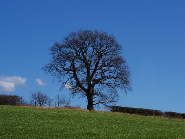
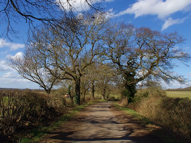
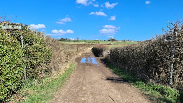
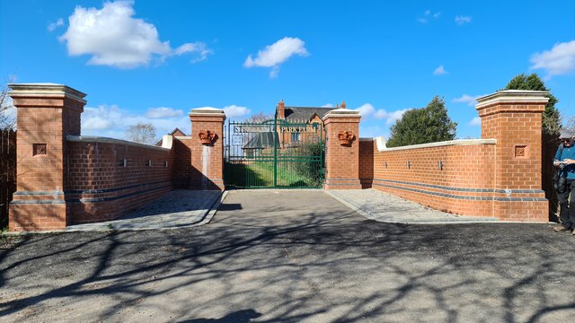
Knowle Wood Images

Images are sourced within 2km of 52.993083/-1.2492573 or Grid Reference SK5044. Thanks to Geograph Open Source API. All images are credited.

Postbox on Maws Lane
On the Robin Hood Way northwest of Kimberley
The Gate Inn at Awsworth A small Local pub in Kimberley. <span class="nowrap"><a title="https://whatpub.com/pubs/NOT/92/gate-inn-awsworth" rel="nofollow ugc noopener" href="https://whatpub.com/pubs/NOT/92/gate-inn-awsworth">Link</a><img style="margin-left:2px;" alt="External link" title="External link - shift click to open in new window" src="https://s1.geograph.org.uk/img/external.png" width="10" height="10"/></span>
The Gate Inn at Awsworth
A small Local pub in Kimberley. LinkExternal link
The Great Northern Railway Path The former Great Northern line between Nottingham and Derby was a casualty of the Beeching era, closing to passengers in 1964 and completely four years later. Here the old trackbed has been converted into a path and cycleway
The Great Northern Railway Path
The former Great Northern line between Nottingham and Derby was a casualty of the Beeching era, closing to passengers in 1964 and completely four years later. Here the old trackbed has been converted into a path and cycleway
St Paul's Court The former St Paul's Methodist Church has been converted to residential use.
St Paul's Court
The former St Paul's Methodist Church has been converted to residential use.
Winter tree on the skyline In a field boundary above Swingate Farm.
Winter tree on the skyline
In a field boundary above Swingate Farm.
Bridleway near Turkey Fields Farm
Steps up to the Great Northern Railway Path The former Great Northern railway between Nottingham and Derby was a casualty of the Beeching era, closing to passengers in 1964 and completely four years later. Here the old trackbed has been converted into a path and cycleway.
Steps up to the Great Northern Railway Path
The former Great Northern railway between Nottingham and Derby was a casualty of the Beeching era, closing to passengers in 1964 and completely four years later. Here the old trackbed has been converted into a path and cycleway.
Swingate Water Tower Opened in 1950 but no longer operational, the tower on Babbington Lane is visible for miles.
Swingate Water Tower
Opened in 1950 but no longer operational, the tower on Babbington Lane is visible for miles.
Old railway track bed near Awsworth Narrow gauge colliery wagon slowly rotting away
Old railway track bed near Awsworth
Narrow gauge colliery wagon slowly rotting away
Former St Paul's Methodist Church, Kimberley
Swingate Water Tower Brought into use in 1950 but no longer operational
Swingate Water Tower
Brought into use in 1950 but no longer operational
Lane by Strelley Park Farm
Gates to Strelley Park Farm
Carved Tree In a tiny nature reserve.
Carved Tree
In a tiny nature reserve.
Miners Return, Kimberley There can be few areas of the country so rich in micropubs as here along the old road from Nottingham to Heanor. One of them is the Miners Return sandwiched between a convenience store and a fish and chip shop on Eastwood Road at Kimberley. This was the site of Kimberley Miners' Welfare (a social club) and the mining heritage is acknowledged in the name of the pub.
Miners Return, Kimberley
There can be few areas of the country so rich in micropubs as here along the old road from Nottingham to Heanor. One of them is the Miners Return sandwiched between a convenience store and a fish and chip shop on Eastwood Road at Kimberley. This was the site of Kimberley Miners' Welfare (a social club) and the mining heritage is acknowledged in the name of the pub.
Rolleston Crescent, Watnall
Access to Strelley Park Farm Access to the farm.
Access to Strelley Park Farm
Access to the farm.
Show me another place!

Knowle Wood is located at Grid Ref: SK5044 (Lat: 52.993083, Lng: -1.2492573)

Administrative County: Nottinghamshire

District: Broxtowe

Police Authority: Nottinghamshire

What 3 Words

///extra.robot.shirts. Near Kimberley, Nottinghamshire

Nearby Locations

Knowle Wood Verge Wood

Related Wikis

Kimberley Town F.C.

Kimberley Town Football Club was a football club based in Kimberley, Nottinghamshire, England. They joined the Midland League in 1971. They reached the...

Kimberley Miners Welfare F.C.

Kimberley Miners Welfare Football Club is a football club based in Kimberley, Nottinghamshire, England. They are currently members of the United Counties...

Swingate, Nottinghamshire

Swingate is a small English village positioned between of Kimberley and Babbington, in the Broxtowe district, in the county of Nottinghamshire. == History... ==

Kimberley, Nottinghamshire

Kimberley is a market town and civil parish in the Borough of Broxtowe in Nottinghamshire, England, lying 6 miles northwest of Nottingham along the A610...

Nearby Amenities

Located within 500m of 52.993083,-1.2492573
Bus Stop
Oak Drive
Bus: yes
Naptan AtcoCode: 3300BR0228
Naptan NaptanCode: ntsdadag
Public Transport: platform
Shelter: no
Lat/Long: 52.995008/-1.2445119
Bus Stop
Nottingham Road
Bus: yes
Naptan AtcoCode: 3300BR0229
Naptan NaptanCode: ntsdadaj
Public Transport: platform
Lat/Long: 52.9957658/-1.2514678
Bus Stop
Nottingham Road
Bus: yes
Public Transport: platform
Lat/Long: 52.9958569/-1.2518942
Bus Stop
Larkfield Road
Bus: yes
Naptan AtcoCode: 3300BR0231
Naptan NaptanCode: ntsdadap
Public Transport: platform
Lat/Long: 52.9941166/-1.2457317
Bus Stop
Larkfield Road
Bus: yes
Naptan AtcoCode: 3300BR0232
Naptan NaptanCode: ntsdadat
Public Transport: platform
Lat/Long: 52.9943091/-1.2437058
Bus Stop
Oak Drive
Bus: yes
Naptan AtcoCode: 3300BR0242
Naptan NaptanCode: ntsawjdt
Public Transport: platform
Shelter: no
Lat/Long: 52.9953251/-1.2446296
Bus Stop
Knowle Lane
Both Ways: yes
Bus: yes
Local Ref: BR0380
Naptan AtcoCode: 3300BR0380
Naptan Bearing: SW
Naptan CommonName: Knowle Lane
Naptan Crossing: Swingate
Naptan Indicator: SW-bound
Naptan NaptanCode: ntsatpga
Naptan Notes: BW--3300BR0515
Naptan Street: Knowle Lane
Naptan Verified: yes
Public Transport: platform
Shelter: yes
Source: naptan_import
Lat/Long: 52.9910388/-1.2535587
Bus Stop
Little Lane
Bus: yes
Local Ref: BR0414
Naptan AtcoCode: 3300BR0414
Naptan Bearing: NW
Naptan CommonName: Little Lane
Naptan Crossing: Little Lane
Naptan Indicator: adj
Naptan NaptanCode: ntsdagdt
Naptan Notes: BW--3300BR0492
Naptan Street: Swingate
Naptan Verified: yes
Public Transport: platform
Shelter: no
Source: naptan_import
Lat/Long: 52.9931455/-1.2555039
Bus Stop
Little Lane
Bus: yes
Naptan AtcoCode: 3300BR0492
Naptan Bearing: S
Naptan BusStopType: CUS
Naptan CommonName: Little Lane
Naptan Crossing: Little Lane
Naptan Indicator: opp
Naptan NaptanCode: ntsgjptg
Naptan Notes: CUS--3300BR0414
Naptan Street: Swingate
Naptan Verified: no
Public Transport: platform
Source: naptan_import
Lat/Long: 52.9931629/-1.2553993
Bus Stop
Knowle Lane
Bus: yes
Naptan AtcoCode: 3300BR0515
Naptan Bearing: NE
Naptan BusStopType: CUS
Naptan CommonName: Knowle Lane
Naptan Indicator: NE-bound
Naptan Landmark: Kimberley Primary School
Naptan NaptanCode: ntsgmtdp
Naptan Notes: CUS--3300BR0380
Naptan Street: Knowle Lane
Naptan Verified: no
Public Transport: platform
Source: naptan_import
Lat/Long: 52.9910844/-1.2536771
Bus Stop
Clive Crescent
Bus: yes
Naptan AtcoCode: 3300BR0551
Naptan Bearing: S
Naptan CommonName: Clive Crescent
Naptan Crossing: Clive Crescent
Naptan Indicator: opp
Naptan NaptanCode: ntsgpatp
Naptan Street: Knowle Lane
Naptan Verified: no
Public Transport: platform
Source: naptan_import
Lat/Long: 52.9925524/-1.2526685
Turning Circle
Lat/Long: 52.989546/-1.2517275
Turning Circle
Lat/Long: 52.9894684/-1.2530729
Leisure: playground
Source: survey
Lat/Long: 52.9932018/-1.2515052
Post Box
Collection Times: Mo-Fr 16:30; Sa 11:45
Operator: Royal Mail
Operator Wikidata: Q638098
Post Box Type: lamp
Ref: NG16 18
Royal Cypher: EIIR
Royal Cypher Wikidata: Q33102113
Source: survey
Lat/Long: 52.9904926/-1.2541564
Entrance: main
Lat/Long: 52.9905441/-1.2543169
Entrance: main
Lat/Long: 52.9955685/-1.2500417
Entrance: main
Lat/Long: 52.9965642/-1.2526671
Barrier: cycle_barrier
Lat/Long: 52.996338/-1.2496158
Recycling
Source: survey
Lat/Long: 52.9957732/-1.2545864
Post Box
Collection Times: Mo-Fr 09:00; Sa 07:00
Post Box Type: pillar
Ref: NG16 19D
Royal Cypher: EIIR
Royal Cypher Wikidata: Q33102113
Source: survey
Lat/Long: 52.9964242/-1.2533004
Entrance: main
Lat/Long: 52.9966588/-1.2533329
Entrance: main
Lat/Long: 52.9966717/-1.2533768
Entrance: main
Lat/Long: 52.9963881/-1.2525445
Barrier: stile
Lat/Long: 52.989901/-1.2485951
Barrier: stile
Lat/Long: 52.9916126/-1.249872
Barrier: stile
Lat/Long: 52.9926173/-1.2506209
Swingate
Note: added as suburb of Kimberley, may be distinct
Place: suburb
Source: OS-OpenData_StreetView
Wikidata: Q9348644
Wikipedia: en:Swingate, Nottinghamshire
Lat/Long: 52.9908994/-1.2529962
Addr Housenumber: 6
Addr Postcode: NG16 2PT
Addr Street: Babbington Lane
Lat/Long: 52.9899368/-1.2544444
Addr Housenumber: 44
Addr Postcode: NG16 2PH
Addr Street: Swingate
Source: survey
Source Postcode: ONS Open Data
Lat/Long: 52.9914922/-1.2550412
Addr Housenumber: 9
Addr Postcode: NG16 2PN
Addr Street: North Street
Source: survey
Source Postcode: ONS Open Data
Lat/Long: 52.9913147/-1.2554594
Addr Housenumber: 19A
Addr Postcode: NG16 2PN
Addr Street: North Street
Source: survey
Source Postcode: ONS Open Data
Lat/Long: 52.9911054/-1.25592
Addr Housenumber: 20
Addr Postcode: NG16 2PN
Addr Street: North Street
Source: survey
Source Postcode: ONS Open Data
Lat/Long: 52.9914473/-1.2559689
Addr Housenumber: 3
Addr Postcode: NG16 2PN
Addr Street: North Street
Source: survey
Source Postcode: ONS Open Data
Lat/Long: 52.9913274/-1.2552911
Addr Housenumber: 15
Addr Postcode: NG16 2PN
Addr Street: North Street
Source: survey
Source Postcode: ONS Open Data
Lat/Long: 52.9912772/-1.2556746
Addr Housenumber: 46
Addr Postcode: NG16 2PH
Addr Street: Swingate
Source: survey
Source Postcode: ONS Open Data
Lat/Long: 52.9913527/-1.254968
Addr Housenumber: 2
Addr Postcode: NG16 2PN
Addr Street: North Street
Source: survey
Source Postcode: ONS Open Data
Lat/Long: 52.991585/-1.2553411
Addr Housenumber: 21
Addr Postcode: NG16 2PN
Addr Street: North Street
Source: survey
Source Postcode: ONS Open Data
Lat/Long: 52.991268/-1.2560497
Addr Housenumber: 26
Addr Postcode: NG16 2PN
Addr Street: North Street
Source: survey
Source Postcode: ONS Open Data
Lat/Long: 52.9914397/-1.256176
Addr Housenumber: 19
Addr Postcode: NG16 2PN
Addr Street: North Street
Source: survey
Source Postcode: ONS Open Data
Lat/Long: 52.9912511/-1.2557926
Addr Housenumber: 4
Addr Postcode: NG16 2PN
Addr Street: North Street
Source: survey
Source Postcode: ONS Open Data
Lat/Long: 52.9915851/-1.2554014
Addr Housenumber: 7
Addr Postcode: NG16 2PN
Addr Street: North Street
Source: survey
Source Postcode: ONS Open Data
Lat/Long: 52.9913195/-1.2554015
Addr Housenumber: 17
Addr Postcode: NG16 2PN
Addr Street: North Street
Source: survey
Source Postcode: ONS Open Data
Lat/Long: 52.9912687/-1.2557297
Addr Housenumber: 6
Addr Postcode: NG16 2PN
Addr Street: North Street
Source: survey
Source Postcode: ONS Open Data
Lat/Long: 52.9915802/-1.2554564
Addr Housenumber: 22
Addr Postcode: NG16 2PN
Addr Street: North Street
Source: survey
Source Postcode: ONS Open Data
Lat/Long: 52.9914462/-1.2560446
Addr Housenumber: 11
Addr Postcode: NG16 2PN
Addr Street: North Street
Source: survey
Source Postcode: ONS Open Data
Lat/Long: 52.9912923/-1.2556148
Addr Housenumber: 10
Addr Postcode: NG16 2PN
Addr Street: North Street
Source: survey
Source Postcode: ONS Open Data
Lat/Long: 52.9915746/-1.2556441
Addr Housenumber: 8
Addr Postcode: NG16 2PN
Addr Street: North Street
Source: survey
Source Postcode: ONS Open Data
Lat/Long: 52.9915892/-1.2555677
Addr Housenumber: 14
Addr Postcode: NG16 2PN
Addr Street: North Street
Source: survey
Source Postcode: ONS Open Data
Lat/Long: 52.9915482/-1.2558749
Addr Housenumber: 5
Addr Postcode: NG16 2PN
Addr Street: North Street
Source: survey
Source Postcode: ONS Open Data
Lat/Long: 52.991324/-1.2553441
Addr Housenumber: 24
Addr Postcode: NG16 2PN
Addr Street: North Street
Source: survey
Source Postcode: ONS Open Data
Lat/Long: 52.9914382/-1.2561144
Addr Housenumber: 12
Addr Postcode: NG16 2PN
Addr Street: North Street
Source: survey
Source Postcode: ONS Open Data
Lat/Long: 52.9915472/-1.2557782
Addr Housenumber: 20
Addr Postcode: NG16 2PZ
Addr Street: Knowle Hill
Source: survey
Source Postcode: ONS Open Data
Lat/Long: 52.9943428/-1.2511246
Addr Housenumber: 10
Addr Postcode: NG16 2PZ
Addr Street: Knowle Hill
Source: survey
Source Postcode: ONS Open Data
Lat/Long: 52.994655/-1.2506424
Addr Housenumber: 18
Addr Postcode: NG16 2PZ
Addr Street: Knowle Hill
Source: survey
Source Postcode: ONS Open Data
Lat/Long: 52.9944457/-1.2510991
Addr Housenumber: 14
Addr Postcode: NG16 2PZ
Addr Street: Knowle Hill
Source: survey
Source Postcode: ONS Open Data
Lat/Long: 52.9945496/-1.2507941
Addr Housenumber: 16
Addr Postcode: NG16 2PZ
Addr Street: Knowle Hill
Source: survey
Source Postcode: ONS Open Data
Lat/Long: 52.9945011/-1.2510583
Addr Housenumber: 12
Addr Postcode: NG16 2PZ
Addr Street: Knowle Hill
Source: survey
Source Postcode: ONS Open Data
Lat/Long: 52.9946125/-1.2507174
Waste Basket
Lat/Long: 52.9940817/-1.2557097
Waste Basket
Lat/Long: 52.9948986/-1.2560517
Bench
Lat/Long: 52.9948776/-1.2560409
Generator Method: photovoltaic
Generator Output Electricity: yes
Generator Source: solar
Generator Type: solar_photovoltaic_panel
Location: roof
Power: generator
Lat/Long: 52.9965176/-1.2483763
Generator Method: photovoltaic
Generator Output Electricity: yes
Generator Source: solar
Generator Type: solar_photovoltaic_panel
Location: roof
Power: generator
Lat/Long: 52.994984/-1.2459087
Generator Method: photovoltaic
Generator Output Electricity: yes
Generator Source: solar
Generator Type: solar_photovoltaic_panel
Location: roof
Power: generator
Lat/Long: 52.9896578/-1.2530652
Generator Method: photovoltaic
Generator Output Electricity: yes
Generator Source: solar
Generator Type: solar_photovoltaic_panel
Location: roof
Power: generator
Lat/Long: 52.9918391/-1.253143
Generator Method: photovoltaic
Generator Output Electricity: yes
Generator Source: solar
Generator Type: solar_photovoltaic_panel
Location: roof
Power: generator
Lat/Long: 52.9919101/-1.2534166
Generator Method: photovoltaic
Generator Output Electricity: yes
Generator Source: solar
Generator Type: solar_photovoltaic_panel
Location: roof
Power: generator
Lat/Long: 52.9917648/-1.253827
Generator Method: photovoltaic
Generator Output Electricity: yes
Generator Source: solar
Generator Type: solar_photovoltaic_panel
Location: roof
Power: generator
Lat/Long: 52.9918552/-1.2539772
Generator Method: photovoltaic
Generator Output Electricity: yes
Generator Source: solar
Generator Type: solar_photovoltaic_panel
Location: roof
Power: generator
Lat/Long: 52.9921264/-1.2542803
Generator Method: photovoltaic
Generator Output Electricity: yes
Generator Source: solar
Generator Type: solar_photovoltaic_panel
Location: roof
Power: generator
Lat/Long: 52.9926479/-1.2531564
Generator Method: photovoltaic
Generator Output Electricity: yes
Generator Source: solar
Generator Type: solar_photovoltaic_panel
Location: roof
Power: generator
Lat/Long: 52.9932501/-1.2528077
Generator Method: photovoltaic
Generator Output Electricity: yes
Generator Source: solar
Generator Type: solar_photovoltaic_panel
Location: roof
Power: generator
Lat/Long: 52.993255/-1.2527461
Generator Method: photovoltaic
Generator Output Electricity: yes
Generator Source: solar
Generator Type: solar_photovoltaic_panel
Location: roof
Power: generator
Lat/Long: 52.9929934/-1.2551144
Generator Method: photovoltaic
Generator Output Electricity: yes
Generator Source: solar
Generator Type: solar_photovoltaic_panel
Location: roof
Power: generator
Lat/Long: 52.9929902/-1.2551869
Generator Method: photovoltaic
Generator Output Electricity: yes
Generator Source: solar
Generator Type: solar_photovoltaic_panel
Location: roof
Power: generator
Lat/Long: 52.9942422/-1.2554551
Generator Method: photovoltaic
Generator Output Electricity: yes
Generator Source: solar
Generator Type: solar_photovoltaic_panel
Location: roof
Power: generator
Lat/Long: 52.9957904/-1.2512896
Generator Method: photovoltaic
Generator Output Electricity: yes
Generator Source: solar
Generator Type: solar_photovoltaic_panel
Location: roof
Power: generator
Lat/Long: 52.9945952/-1.2500374
Generator Method: photovoltaic
Generator Output Electricity: yes
Generator Source: solar
Generator Type: solar_photovoltaic_panel
Location: roof
Power: generator
Lat/Long: 52.9935834/-1.2461401
Generator Method: photovoltaic
Generator Output Electricity: yes
Generator Source: solar
Generator Type: solar_photovoltaic_panel
Location: roof
Power: generator
Lat/Long: 52.9939225/-1.2420481
Generator Method: photovoltaic
Generator Output Electricity: yes
Generator Source: solar
Generator Type: solar_photovoltaic_panel
Location: roof
Power: generator
Lat/Long: 52.9949869/-1.2498366
Kimberley Colliery
End Date: 1896
Historic: mine
Mineral: coal
Start Date: 1860
Lat/Long: 52.9922857/-1.2536387
Give Way
Direction: forward
Lat/Long: 52.9942028/-1.2482451
The data included in this document is from www.openstreetmap.org. The data is made available under ODbL.

Have you been to Knowle Wood?

Leave your review of Knowle Wood below (or comments, questions and feedback).