Donnington

Settlement in Gloucestershire Cotswold

England

Donnington

Lower Farmhouse Late 18th/early 19th Century farmhouse with later additions.  Grade II listed - see <span class="nowrap"><a title="www.historicengland.org.uk/listing/the-list/list-entry/1154846" rel="nofollow ugc noopener" href="http://www.historicengland.org.uk/listing/the-list/list-entry/1154846">Link</a><img style="margin-left:2px;" alt="External link" title="External link - shift click to open in new window" src="https://s1.geograph.org.uk/img/external.png" width="10" height="10"/></span>.
Lower Farmhouse Credit: Ian Capper

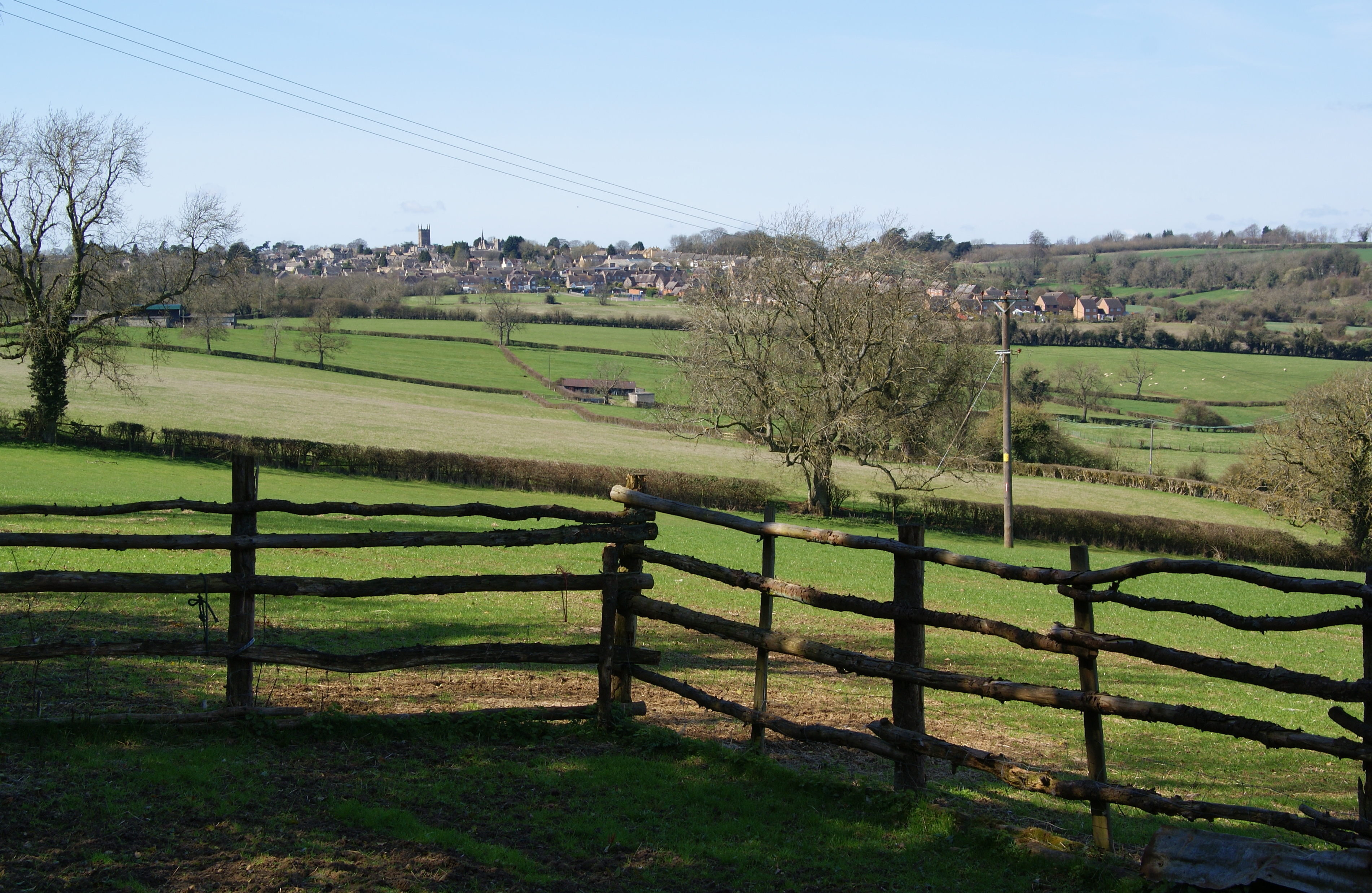
Donnington is a small village located in the county of Gloucestershire, England. Situated in the Cotswold district, it lies approximately 5 miles southwest of the market town of Stow-on-the-Wold. The village is nestled within the picturesque countryside, surrounded by rolling hills and abundant greenery.

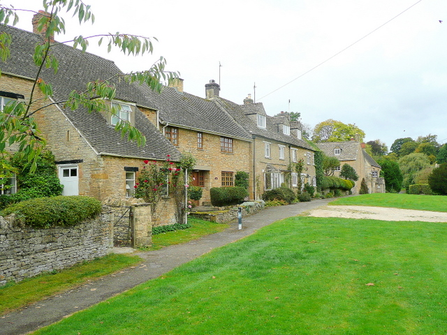
Donnington is known for its quaint and charming atmosphere, with a population of around 200 residents. The village is home to a mix of traditional Cotswold stone cottages and more modern houses, creating a unique blend of architectural styles.

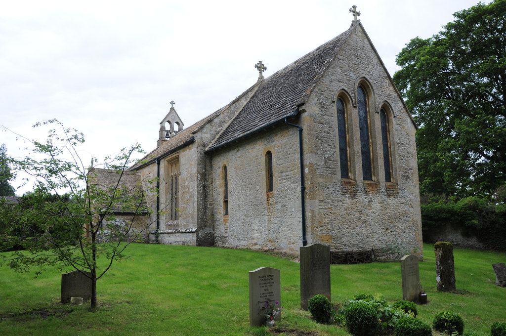
The heart of Donnington is its historic church, St. Mary's, which dates back to the 12th century. This beautiful church is a focal point of the community and attracts visitors from near and far. The village also features a small primary school, providing education for local children.

Despite its small size, Donnington boasts a strong sense of community spirit. Residents often come together for various events and activities, such as the annual village fete and Christmas celebrations. The village pub, The Donnington Arms, serves as a social hub and gathering place for locals and visitors alike.

Surrounded by scenic countryside, Donnington offers plenty of opportunities for outdoor pursuits. The village is a popular starting point for hiking and walking trails, with access to the Cotswold Way and other picturesque routes.

In summary, Donnington is a charming and tight-knit village in Gloucestershire, known for its idyllic setting, historic church, and sense of community. It is a place where residents can enjoy the beauty of the English countryside while embracing a strong local spirit.

If you have any feedback on the listing, please let us know in the comments section below.

Donnington Images

Images are sourced within 2km of 51.950964/-1.7214333 or Grid Reference SP1928. Thanks to Geograph Open Source API. All images are credited.

Lower Farmhouse Late 18th/early 19th Century farmhouse with later additions.  Grade II listed - see <span class="nowrap"><a title="www.historicengland.org.uk/listing/the-list/list-entry/1154846" rel="nofollow ugc noopener" href="http://www.historicengland.org.uk/listing/the-list/list-entry/1154846">Link</a><img style="margin-left:2px;" alt="External link" title="External link - shift click to open in new window" src="https://s1.geograph.org.uk/img/external.png" width="10" height="10"/></span>.
Lower Farmhouse
Late 18th/early 19th Century farmhouse with later additions. Grade II listed - see LinkExternal link.
Broadwell Manor 17th Century manor house rebuilt in 1757 after a fire, then with later additions.  Grade II* listed - see <span class="nowrap"><a title="www.historicengland.org.uk/listing/the-list/list-entry/1089783" rel="nofollow ugc noopener" href="http://www.historicengland.org.uk/listing/the-list/list-entry/1089783">Link</a><img style="margin-left:2px;" alt="External link" title="External link - shift click to open in new window" src="https://s1.geograph.org.uk/img/external.png" width="10" height="10"/></span>.
Broadwell Manor
17th Century manor house rebuilt in 1757 after a fire, then with later additions. Grade II* listed - see LinkExternal link.
Broadwell Farm Early 18th Century farmhouse with attached yard entrance/hay loft.  Grade II listed - see <span class="nowrap"><a title="www.historicengland.org.uk/listing/the-list/list-entry/1341091" rel="nofollow ugc noopener" href="http://www.historicengland.org.uk/listing/the-list/list-entry/1341091">Link</a><img style="margin-left:2px;" alt="External link" title="External link - shift click to open in new window" src="https://s1.geograph.org.uk/img/external.png" width="10" height="10"/></span>.
Broadwell Farm
Early 18th Century farmhouse with attached yard entrance/hay loft. Grade II listed - see LinkExternal link.
Broadwell Farm Looking towards Broadwell Farm.  The farmhouse itself, dating from the early 18th Century, is just visible in the centre of the photo with the later outbuildings on the right.  Both the farmhouse and outbuildings are grade II listed - see <span class="nowrap"><a title="www.historicengland.org.uk/listing/the-list/list-entry/1341091" rel="nofollow ugc noopener" href="http://www.historicengland.org.uk/listing/the-list/list-entry/1341091">Link</a><img style="margin-left:2px;" alt="External link" title="External link - shift click to open in new window" src="https://s1.geograph.org.uk/img/external.png" width="10" height="10"/></span> and <span class="nowrap"><a title="www.historicengland.org.uk/listing/the-list/list-entry/1341110" rel="nofollow ugc noopener" href="http://www.historicengland.org.uk/listing/the-list/list-entry/1341110">Link</a><img style="margin-left:2px;" alt="External link" title="External link - shift click to open in new window" src="https://s1.geograph.org.uk/img/external.png" width="10" height="10"/></span>.
Broadwell Farm
Looking towards Broadwell Farm. The farmhouse itself, dating from the early 18th Century, is just visible in the centre of the photo with the later outbuildings on the right. Both the farmhouse and outbuildings are grade II listed - see LinkExternal link and LinkExternal link.
Broadwell Farm Looking towards Broadwell Farm.  The farmhouse itself, dating from the early 18th Century, is just visible on the left of the photo with the later outbuildings on the right.  Both the farmhouse and outbuildings are grade II listed - see <span class="nowrap"><a title="www.historicengland.org.uk/listing/the-list/list-entry/1341091" rel="nofollow ugc noopener" href="http://www.historicengland.org.uk/listing/the-list/list-entry/1341091">Link</a><img style="margin-left:2px;" alt="External link" title="External link - shift click to open in new window" src="https://s1.geograph.org.uk/img/external.png" width="10" height="10"/></span> and <span class="nowrap"><a title="www.historicengland.org.uk/listing/the-list/list-entry/1341110" rel="nofollow ugc noopener" href="http://www.historicengland.org.uk/listing/the-list/list-entry/1341110">Link</a><img style="margin-left:2px;" alt="External link" title="External link - shift click to open in new window" src="https://s1.geograph.org.uk/img/external.png" width="10" height="10"/></span>.
Broadwell Farm
Looking towards Broadwell Farm. The farmhouse itself, dating from the early 18th Century, is just visible on the left of the photo with the later outbuildings on the right. Both the farmhouse and outbuildings are grade II listed - see LinkExternal link and LinkExternal link.
Timperley, Studio and Pimlico Cottages Row of cottages built in the 1850s.  Grade II listed - see <span class="nowrap"><a title="www.historicengland.org.uk/listing/the-list/list-entry/1303579" rel="nofollow ugc noopener" href="http://www.historicengland.org.uk/listing/the-list/list-entry/1303579">Link</a><img style="margin-left:2px;" alt="External link" title="External link - shift click to open in new window" src="https://s1.geograph.org.uk/img/external.png" width="10" height="10"/></span>.
Timperley, Studio and Pimlico Cottages
Row of cottages built in the 1850s. Grade II listed - see LinkExternal link.
The Fox Inn Pub on the village green with records going back to at least the 1890s.  On the left is Rose's Cottage.
The Fox Inn
Pub on the village green with records going back to at least the 1890s. On the left is Rose's Cottage.
Green Cottage and Wheatsheaf House Two houses on the edge of the village green.  Wheatsheaf House, on the right, originates from the late 17th/early 18th Century and was once a pub, closing in the early 20th Century.  It is grade II listed - see <span class="nowrap"><a title="www.historicengland.org.uk/listing/the-list/list-entry/1089790" rel="nofollow ugc noopener" href="http://www.historicengland.org.uk/listing/the-list/list-entry/1089790">Link</a><img style="margin-left:2px;" alt="External link" title="External link - shift click to open in new window" src="https://s1.geograph.org.uk/img/external.png" width="10" height="10"/></span>.
Green Cottage and Wheatsheaf House
Two houses on the edge of the village green. Wheatsheaf House, on the right, originates from the late 17th/early 18th Century and was once a pub, closing in the early 20th Century. It is grade II listed - see LinkExternal link.
Seat and rock Commemorative seat and rock on the village green, acknowledging the gift of the green to the village by Lord Ashton of Broadwell Hill, who owned around 300 ha of the village.
Seat and rock
Commemorative seat and rock on the village green, acknowledging the gift of the green to the village by Lord Ashton of Broadwell Hill, who owned around 300 ha of the village.
Broadwell Ford Ford across the brook that runs alongside the village green.  In the background, behind the K6 phone box, is the village hall.
Broadwell Ford
Ford across the brook that runs alongside the village green. In the background, behind the K6 phone box, is the village hall.
Defibrillator phone box A K6 phone box in front of the village hall, containing a defibrillator as indicated by the sign on the post above it.  For wider view see <a href="https://www.geograph.org.uk/photo/5434066">SP2027 : Broadwell Ford</a>.
Defibrillator phone box
A K6 phone box in front of the village hall, containing a defibrillator as indicated by the sign on the post above it. For wider view see SP2027 : Broadwell Ford.
Duck race A duck race under way on the brook that runs alongside the village green.  Duck racing is a feature of the Broadwell and Donnington village fete that was due to take place the following weekend.  This particular race was a private event as part of a wedding celebration taking place in the village.
Duck race
A duck race under way on the brook that runs alongside the village green. Duck racing is a feature of the Broadwell and Donnington village fete that was due to take place the following weekend. This particular race was a private event as part of a wedding celebration taking place in the village.
The Church of St Paul at Broadwell Viewed from the south.
The Church of St Paul at Broadwell
Viewed from the south.
Ordnance Survey Cut Mark This mark can be found on the wall of St Paul's Church in Broadwell. The benchmark height is recorded as being 156.18 metres above seal level. For more detail see : <span class="nowrap"><a title="http://www.bench-marks.org.uk/bm59230" rel="nofollow ugc noopener" href="http://www.bench-marks.org.uk/bm59230">Link</a><img style="margin-left:2px;" alt="External link" title="External link - shift click to open in new window" src="https://s1.geograph.org.uk/img/external.png" width="10" height="10"/></span>
Ordnance Survey Cut Mark
This mark can be found on the wall of St Paul's Church in Broadwell. The benchmark height is recorded as being 156.18 metres above seal level. For more detail see : LinkExternal link
Broadwell - St Paul's Church
Broadwell - Manor House
Broadwell Farm View from Chapel Street.
Broadwell Farm
View from Chapel Street.
St Paul's Church, Broadwell
Show me another place!

Donnington is located at Grid Ref: SP1928 (Lat: 51.950964, Lng: -1.7214333)

Administrative County: Gloucestershire

District: Cotswold

Police Authority: Gloucestershire

What 3 Words

///evolves.models.pods. Near Donnington, Gloucestershire

Related Wikis

Donnington, Gloucestershire

Donnington is a small village and civil parish in Gloucestershire, near the Roman Fosse Way in the Cotswold District Council area of south west England...

Battle of Stow-on-the-Wold

The Battle of Stow-on-the-Wold (21 March 1646) took place during the First English Civil War. It was a Parliamentarian victory by detachments of the New...

Longborough

Longborough is a village and civil parish 2.5 miles (4.0 km) north of the market town of Stow on the Wold, Gloucestershire. The parish population taken...

Broadwell, Cotswold

Broadwell is a village and civil parish in the English county of Gloucestershire. It is about 1.5 miles (2.4 km) north of Stow-on-the-Wold, In the 2001...

New Park Quarry

New Park Quarry (grid reference SP175282) is a 1.3-hectare (3.2-acre) geological Site of Special Scientific Interest in Gloucestershire, notified in 1987...

Church of St Mary, Upper Swell

The Anglican Church of St Mary at Upper Swell in the Cotswold District of Gloucestershire, England was built in the 12th century. It is a Grade I listed...

Abbotswood, Gloucestershire

Abbotswood is a country house and estate near Lower Swell in Gloucestershire, England. It is a grade II listed building and estate, of medieval origins...

St James' Church, Longborough

St James' Church is the Church of England parish church of Longborough, Gloucestershire, England. It is in the deanery of Stow, the archdeaconry of Cheltenham...

Nearby Amenities

Located within 500m of 51.950964,-1.7214333
Barrier: stile
Source: survey
Lat/Long: 51.9521636/-1.7215546
Barrier: stile
Source: survey
Lat/Long: 51.9518309/-1.7244417
Barrier: stile
Source: survey
Lat/Long: 51.9518114/-1.728011
Bus Stop
Donnington
Bus: yes
Naptan AtcoCode: 1600GL1615
Naptan Bearing: S
Naptan CommonName: Donnington
Naptan NaptanCode: glogjdtj
Naptan Street: N/A
Naptan Verified: no
Public Transport: platform
Source: naptan_import
Lat/Long: 51.9505339/-1.7215306
Bus Stop
Donnington
Bus: yes
Naptan AtcoCode: 1600GL1616
Naptan Bearing: N
Naptan CommonName: Donnington
Naptan NaptanCode: glogjdtd
Naptan Street: N/A
Naptan Verified: no
Public Transport: platform
Shelter: yes
Source: naptan_import
Lat/Long: 51.9505558/-1.7216541
Bus Stop
Ivy Lodge
Bench: no
Bin: no
Bus: yes
Lit: no
Naptan AtcoCode: 1600GLC441
Naptan Bearing: NW
Naptan CommonName: Ivy Lodge
Naptan NaptanCode: glogjdwg
Naptan Street: Donnington Lane
Naptan Verified: no
Public Transport: platform
Shelter: no
Source: naptan_import
Tactile Paving: no
Lat/Long: 51.950045/-1.7151627
Bus Stop
Ivy Lodge
Bench: no
Bin: no
Bus: yes
Check Date Lit: 2023-04-10
Lit: no
Naptan AtcoCode: 1600GLC442
Naptan Bearing: SE
Naptan CommonName: Ivy Lodge
Naptan NaptanCode: glogjdwj
Naptan Street: Donnington Lane
Naptan Verified: no
Public Transport: platform
Shelter: no
Source: naptan_import
Tactile Paving: no
Lat/Long: 51.9501618/-1.7151183
Battle of Stow 1646
Information: interpretive_board
Tourism: information
Lat/Long: 51.9517103/-1.7281364
Public Bookcase
Booth: K6
Colour: red
Disused Amenity: telephone
Man Made: telephone_box
Public Bookcase Type: phone_box
Source: visual survey;estimate
Lat/Long: 51.9506104/-1.7216232
Power: substation
Source: survey
Lat/Long: 51.9511338/-1.7197309
Material: wood
Power: pole
Source: bing
Lat/Long: 51.9509689/-1.7204976
Material: wood
Power: pole
Source: bing
Lat/Long: 51.9509242/-1.718789
Material: wood
Power: pole
Source: bing
Lat/Long: 51.9504358/-1.7174989
Material: wood
Power: pole
Source: bing
Lat/Long: 51.9504093/-1.7163965
Material: wood
Power: pole
Source: bing
Lat/Long: 51.9503886/-1.7155972
Material: wood
Power: pole
Source: bing
Lat/Long: 51.9503555/-1.7147496
Material: wood
Power: pole
Source: bing
Lat/Long: 51.9502183/-1.7142722
Bench
Lat/Long: 51.9505795/-1.7216376
Power: pole
Lat/Long: 51.954399/-1.7243546
Power: pole
Lat/Long: 51.9532849/-1.725449
Power: pole
Lat/Long: 51.9520583/-1.726554
Power: pole
Lat/Long: 51.951159/-1.727348
Power: pole
Lat/Long: 51.9481858/-1.7263084
Power: pole
Lat/Long: 51.9486781/-1.7275144
Power: pole
Lat/Long: 51.9466179/-1.7226816
Home Leigh
Power: pole
Transformer: distribution
Voltage Primary: 11000
Lat/Long: 51.9470994/-1.7230667
Power: pole
Lat/Long: 51.947815/-1.723673
Location Transition: yes
Power: pole
Lat/Long: 51.9481124/-1.7238765
Donnington Manor Farm
Power: pole
Transformer: distribution
Voltage Primary: 11000
Lat/Long: 51.9512317/-1.719638
Power: pole
Lat/Long: 51.9502084/-1.7216241
Power: pole
Lat/Long: 51.9490045/-1.7241877
Power: pole
Lat/Long: 51.9493438/-1.7234051
Power: pole
Lat/Long: 51.9496364/-1.7225629
The Chapel
Power: pole
Transformer: distribution
Voltage Primary: 11000
Lat/Long: 51.9499055/-1.7220721
The data included in this document is from www.openstreetmap.org. The data is made available under ODbL.

Have you been to Donnington?

Leave your review of Donnington below (or comments, questions and feedback).