Donington on Bain

Settlement in Lincolnshire East Lindsey

England

Donington on Bain

Direction Sign – Signpost north of Donington on Bain Located on a grass triangle in the centre of the junction of Welsdale Road and Mill Road in Donington on Bain parish. 3 arms and no finial. See also <a title="https://www.geograph.org.uk/photo/3818564" href="https://www.geograph.org.uk/photo/3818564">Link</a>.

Milestone Society National ID: LI_TF2383
Direction Sign – Signpost north of Donington on Bain Credit: A Riley

Donington on Bain is a small village located in the county of Lincolnshire in eastern England. Situated on the eastern edge of the Lincolnshire Wolds, it is surrounded by picturesque countryside and offers a peaceful and idyllic setting.

The village is home to a population of around 300 people and is characterized by its charming and traditional English village atmosphere. Donington on Bain boasts a rich history, with evidence of occupation dating back to the Roman period. The village is mentioned in the Domesday Book of 1086, highlighting its long-standing presence in the region.

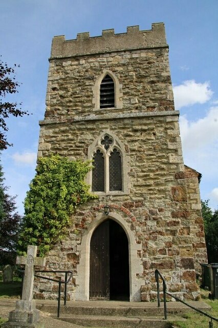
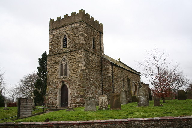
The heart of the village is centered around the parish church of St. Andrew, a beautiful medieval building that stands as a testament to the village's heritage. Other notable landmarks include the village hall, a focal point for community events and gatherings.

Surrounded by rolling hills and scenic countryside, Donington on Bain offers ample opportunities for outdoor activities such as hiking, cycling, and nature walks. The village is also conveniently located near the Viking Way, a long-distance footpath that stretches across the Lincolnshire Wolds.

While Donington on Bain may be small in size, it benefits from its close proximity to larger towns and cities. The market town of Louth is just a few miles away, offering a range of amenities including shops, restaurants, and leisure facilities.

In summary, Donington on Bain is a charming and historic village nestled in the heart of the Lincolnshire Wolds. With its picturesque surroundings and strong community spirit, it offers a peaceful and welcoming retreat for both residents and visitors alike.

If you have any feedback on the listing, please let us know in the comments section below.

Donington on Bain Images

Images are sourced within 2km of 53.328005/-0.142987 or Grid Reference TF2382. Thanks to Geograph Open Source API. All images are credited.

Direction Sign – Signpost north of Donington on Bain Located on a grass triangle in the centre of the junction of Welsdale Road and Mill Road in Donington on Bain parish. 3 arms and no finial. See also <a title="https://www.geograph.org.uk/photo/3818564" href="https://www.geograph.org.uk/photo/3818564">Link</a>.

Milestone Society National ID: LI_TF2383
Direction Sign – Signpost north of Donington on Bain
Located on a grass triangle in the centre of the junction of Welsdale Road and Mill Road in Donington on Bain parish. 3 arms and no finial. See also Link. Milestone Society National ID: LI_TF2383
Direction Sign – Signpost NW of Donington on Bain Located on the south side of a T junction northwest of Donington on Bain in Benniworth parish. 3 arms and no finial.

Milestone Society National ID: LI_TF2283
Direction Sign – Signpost NW of Donington on Bain
Located on the south side of a T junction northwest of Donington on Bain in Benniworth parish. 3 arms and no finial. Milestone Society National ID: LI_TF2283
Church of St. Andrew, Donington on Bain 2021 (2)
Church of St. Andrew, Donington on Bain 2021 (3)
Church of St. Andrew, Donington on Bain 2021 (4)
Church of St. Andrew, Donington on Bain 2021 (5)
Church of St. Andrew, Donington on Bain 2021 (6)
Church of St. Andrew, Donington on Bain 2021 (7)
Church of St. Andrew, Donington on Bain 2021 (8) tower
Church of St. Andrew, Donington on Bain 2021 (9)
Church of St. Andrew, Donington on Bain 2021 (10) plaster saint
Church of St. Andrew, Donington on Bain 2021 (11) corbel
Plantations and covert, Market Stainton: aerial 2022
Donington on Bain: aerial 2022
River Bain, Donington on Bain: aerial 2022 Disused Louth-Bardney railway across the bottom.
River Bain, Donington on Bain: aerial 2022
Disused Louth-Bardney railway across the bottom.
Donington on Bain: aerial 2022
Plantations north of Stenigot: aerial 2022 Red Hill, Nob Hill, Parvek Hole.
Plantations north of Stenigot: aerial 2022
Red Hill, Nob Hill, Parvek Hole.
Plantations north of Stenigot: aerial 2022 (2)
Show me another place!

Donington on Bain is located at Grid Ref: TF2382 (Lat: 53.328005, Lng: -0.142987)

Division: Parts of Lindsey

Administrative County: Lincolnshire

District: East Lindsey

Police Authority: Lincolnshire

What 3 Words

///milk.corals.squirted. Near Louth, Lincolnshire

Nearby Locations

Donington on Bain

Related Wikis

Donington on Bain

Donington on Bain is a village and civil parish in the East Lindsey district of Lincolnshire, England. The village is approximately 6 miles (10 km) south...

Louth to Bardney Line

The Louth to Bardney Line was an English railway line built by the Louth and Lincoln Railway Company, in Lincolnshire, England. It opened in stages between...

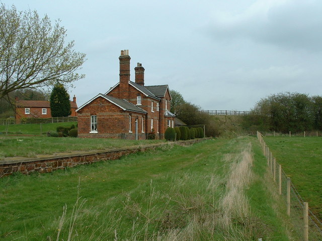
Donington on Bain railway station

Donington railway station was a station in the village of Donington on Bain, Lincolnshire, England. == History == The Great Northern Railway planned and...

RAF Stenigot

RAF Stenigot is a former Second World War radar station situated at Stenigot, near Donington on Bain, Lincolnshire. == Second World War == It was built...

Nearby Amenities

Located within 500m of 53.328005,-0.142987
Donington on Bain
Is In: Lincolnshire, England, UK
Place: village
Source: Bing
Lat/Long: 53.3290828/-0.1456257
Bus Stop
St Andrew's Church
Naptan AtcoCode: 270000014406
Naptan Bearing: NW
Naptan CommonName: St Andrew's Church
Naptan Indicator: opp
Naptan Landmark: St Andrew's Church
Naptan NaptanCode: linjpmjm
Naptan Street: Main Road
Naptan Verified: no
Source: naptan_import
Lat/Long: 53.3291747/-0.1464393
Bus Stop
St Andrew's Church
Naptan AtcoCode: 2700LDBP3018
Naptan Bearing: SE
Naptan CommonName: St Andrew's Church
Naptan Indicator: adj
Naptan Landmark: St Andrew's Church
Naptan NaptanCode: linawgdj
Naptan Street: Mill Road
Naptan Verified: no
Source: naptan_import
Lat/Long: 53.3294872/-0.1468763
Ivy House Farm
Place: farm
Source: Bing
Lat/Long: 53.3293086/-0.1492475
Pub
Black Horse Inn
Addr City: Louth
Addr Country: GB
Addr Postcode: LN11 9TJ
Addr Street: Main Road
Addr Village: Donington On Bain
Fhrs Authority: East Lindsey
Fhrs Id: 155825
Fhrs Local Authority Id: EHFDI/00989/08
Source: survey
Lat/Long: 53.3287197/-0.144842
J. Ward
Addr City: Louth
Addr Country: GB
Addr Postcode: LN11 9TJ
Addr Street: Main Road
Addr Village: Donington On Bain
Fhrs Authority: East Lindsey
Fhrs Id: 156193
Fhrs Local Authority Id: EHFDI/02259/08
Shop: convenience
Source: survey
Lat/Long: 53.3285698/-0.1444029
Dairy Farm Cottage
Place: isolated_dwelling
Source: Bing
Lat/Long: 53.326111/-0.1414307
Post Office
Post & Pantry
Addr City: Louth
Addr Country: GB
Addr Postcode: LN11 9TJ
Addr Street: Main Road
Addr Village: Donington On Bain
Fhrs Authority: East Lindsey
Fhrs Id: 156194
Fhrs Local Authority Id: EHFDI/02262/08
Shop: convenience
Lat/Long: 53.3295272/-0.1468717
Generator Method: photovoltaic
Generator Output Electricity: yes
Generator Source: solar
Generator Type: solar_photovoltaic_panel
Location: roof
Power: generator
Lat/Long: 53.3294425/-0.1486513
Generator Method: photovoltaic
Generator Output Electricity: yes
Generator Source: solar
Generator Type: solar_photovoltaic_panel
Location: roof
Power: generator
Lat/Long: 53.3293496/-0.1441666
Generator Method: photovoltaic
Generator Output Electricity: yes
Generator Source: solar
Generator Type: solar_photovoltaic_panel
Location: roof
Power: generator
Lat/Long: 53.3285999/-0.1453897
Generator Method: photovoltaic
Generator Output Electricity: yes
Generator Source: solar
Generator Type: solar_photovoltaic_panel
Location: roof
Power: generator
Lat/Long: 53.3276027/-0.1436664
Generator Method: photovoltaic
Generator Output Electricity: yes
Generator Source: solar
Generator Type: solar_photovoltaic_panel
Location: roof
Power: generator
Lat/Long: 53.3279095/-0.1436235
Generator Method: photovoltaic
Generator Output Electricity: yes
Generator Source: solar
Generator Type: solar_photovoltaic_panel
Location: roof
Power: generator
Lat/Long: 53.3284709/-0.1424567
Generator Method: photovoltaic
Generator Output Electricity: yes
Generator Source: solar
Generator Type: solar_photovoltaic_panel
Location: roof
Power: generator
Lat/Long: 53.3280005/-0.1445913
Generator Method: photovoltaic
Generator Output Electricity: yes
Generator Source: solar
Generator Type: solar_photovoltaic_panel
Location: roof
Power: generator
Lat/Long: 53.3279911/-0.1445438
Recycling
Recycling Type: container
Lat/Long: 53.3273332/-0.1425351
Shelter
Shelter Type: public_transport
Lat/Long: 53.3272873/-0.1425163
Historic: memorial
Memorial: war_memorial
Lat/Long: 53.3293302/-0.1464341
Clock
Display: analog
Support: wall_mounted
Lat/Long: 53.3288026/-0.1451686
Entrance: yes
Lat/Long: 53.3288935/-0.1450602
Defibrillator
Access: yes
Defibrillator Location: outside Donington On Bain Village Hall
Emergency: defibrillator
Indoor: no
Lat/Long: 53.3288857/-0.1450323
The data included in this document is from www.openstreetmap.org. The data is made available under ODbL.

Have you been to Donington on Bain?

Leave your review of Donington on Bain below (or comments, questions and feedback).