Doncaster Common

Settlement in Yorkshire

England

Doncaster Common

Northumberland Avenue, Intake Seen from its junction with Grasmere Avenue.
Northumberland Avenue, Intake Credit: Richard Vince

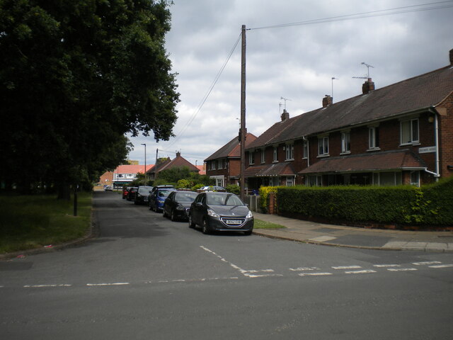
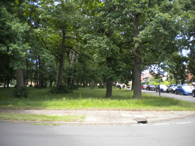
Doncaster Common is a vast open space located in South Yorkshire, England. Covering an area of approximately 500 acres, it is a popular recreational area for both locals and visitors alike. The common is situated just outside the town of Doncaster, making it easily accessible to residents and tourists.

The landscape of Doncaster Common is predominantly flat, with a mixture of grassland, heathland, and woodland. The common is home to a diverse array of plant and animal species, making it an important ecological site within the region. Visitors can spot a variety of bird species, including skylarks, meadow pipits, and kestrels, while the woodland areas are inhabited by squirrels, rabbits, and foxes.

The common offers an abundance of recreational activities to suit all ages and interests. There are numerous walking and cycling paths, providing opportunities for leisurely strolls or more vigorous workouts. Picnic areas and benches are scattered throughout the common, allowing visitors to relax and enjoy the tranquil surroundings. Dog owners can take advantage of the designated dog-walking areas where their pets can roam off-leash.

Historically, Doncaster Common has been used for a range of purposes, including grazing livestock and horse racing. Today, it continues to host various events and festivals, attracting large crowds from the local community and beyond.

Overall, Doncaster Common is a picturesque and diverse natural area that offers a peaceful retreat from the hustle and bustle of urban life. With its rich wildlife, scenic landscapes, and recreational amenities, it is a cherished gem in the heart of Yorkshire.

If you have any feedback on the listing, please let us know in the comments section below.

Doncaster Common Images

Images are sourced within 2km of 53.511268/-1.0967116 or Grid Reference SE6002. Thanks to Geograph Open Source API. All images are credited.

Northumberland Avenue, Intake Seen from its junction with Grasmere Avenue.
Northumberland Avenue, Intake
Seen from its junction with Grasmere Avenue.
Grasmere Avenue, Intake Off Northumberland Avenue.
Grasmere Avenue, Intake
Off Northumberland Avenue.
Copse off Northumberland Avenue, Intake One of the green spaces that parallels Shaftesbury Avenue, the main distributor road through this part of Intake.
Copse off Northumberland Avenue, Intake
One of the green spaces that parallels Shaftesbury Avenue, the main distributor road through this part of Intake.
Doncaster Racecourse and Town Moor Golf Course: aerial 2022
Daffodils on Sandall Beat Road This tree-lined road runs parallel to the straight mile on Doncaster Reacecourse <a href="https://www.geograph.org.uk/photo/1683228">SE6003 : Straight mile.</a>
Daffodils on Sandall Beat Road
This tree-lined road runs parallel to the straight mile on Doncaster Reacecourse SE6003 : Straight mile.
Goffs UK Sales Complex A racehorse auction house located beside Doncaster Racecourse
Goffs UK Sales Complex
A racehorse auction house located beside Doncaster Racecourse
Cantley Water Tower
Cantley Water Tower
Goodison Boluevard and Church Street, Bessacar
Cantley Water Towers
Bessacar Evangelical Church
Former level crossing keepers cottage Greatly improved in fairly recent times but now slipping into dereliction. 

The former Dearne Valley Railway became part of the LMS which met the LNER at Bessacarr Junction just west of this point.
Former level crossing keepers cottage
Greatly improved in fairly recent times but now slipping into dereliction. The former Dearne Valley Railway became part of the LMS which met the LNER at Bessacarr Junction just west of this point.
St.Wilfrid's church, Cantley Norman origins, some 13th century lancet windows, Decorated south arcade and Perpendicular tower. Some restoration by Sir Ninian Comper in 1892-4.
St.Wilfrid's church, Cantley
Norman origins, some 13th century lancet windows, Decorated south arcade and Perpendicular tower. Some restoration by Sir Ninian Comper in 1892-4.
St. Wilfrid's church, Cantley
Bessacarr Evangelical Bessacarr Evangelical church welcomes all according to the sign by the road.  Don't take a camera with you though when the lady that does the gardening is around, she is not very welcoming at all.
Bessacarr Evangelical
Bessacarr Evangelical church welcomes all according to the sign by the road. Don't take a camera with you though when the lady that does the gardening is around, she is not very welcoming at all.
Concrete Church This pre-fabricated concrete church is dedicated to St Francis of Assisi.
Concrete Church
This pre-fabricated concrete church is dedicated to St Francis of Assisi.
Ellers Avenue Perhaps once there were trees lining this avenue?
Ellers Avenue
Perhaps once there were trees lining this avenue?
Church of Hugh of Lincoln, New Cantley
The Bechers Brook Public House, New Cantley
Show me another place!

Doncaster Common is located at Grid Ref: SE6002 (Lat: 53.511268, Lng: -1.0967116)

Division: West Riding

Unitary Authority: Doncaster

Police Authority: South Yorkshire

What 3 Words

///fines.slug.hills. Near Doncaster, South Yorkshire

Related Wikis

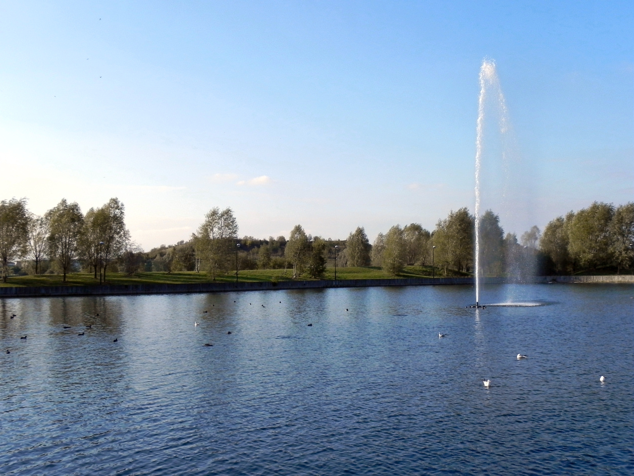
Lakeside, South Yorkshire

Lakeside is a suburb of Doncaster, South Yorkshire, England, centred around a circular lake. Approximately 2 miles (3.2 km) south-east of central Doncaster...
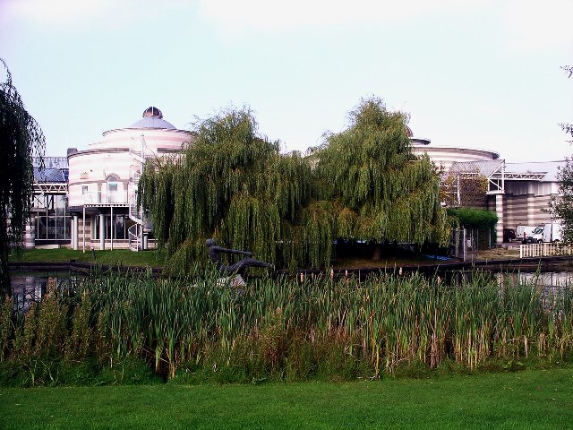
Dome Leisure Centre

The Dome Leisure Centre is an arena and leisure centre in Doncaster, England, commonly referred to as The Dome or Doncaster Dome. It has a swimming complex...

Belle Vue, South Yorkshire

Belle Vue is an inner suburb of Doncaster, South Yorkshire, England. It was the location of the home ground of Doncaster Rovers F.C. and the Doncaster...

Belle Vue (Doncaster)

Belle Vue was a football stadium in Doncaster, South Yorkshire, England, that served as the home ground of Doncaster Rovers from 1922 to 2007. The ground...

Nearby Amenities

Located within 500m of 53.511268,-1.0967116
Traffic Signals
Lat/Long: 53.5129697/-1.0915472
Crossing
Lat/Long: 53.5070857/-1.0975312
Fuel
Shell
Addr City: Doncaster
Addr Housenumber: 4
Addr Postcode: DN4 5NW
Addr Street: Bawtry Road
Brand: Shell
Brand Wikidata: Q110716465
Website: https://find.shell.com/gb/fuel/12427229-racecourse-service-station
Lat/Long: 53.5149242/-1.0953415
Bus Stop
Bawtry Road/The Avenue
Alt Name: Bawtry Road/The Avenue
Naptan AltCommonName: Bawtry Road/The Avenue
Naptan AtcoCode: 370040433
Naptan Bearing: N
Naptan CommonName: Bawtry Road/The Avenue
Naptan Indicator: 40433
Naptan Landmark: TELEPHONE AND POST BOX/TYAS A
Naptan PlusbusZoneRef: ROTHCEN
Naptan Street: Bawtry Road
Naptan Verified: no
Source: naptan_import
Lat/Long: 53.5134937/-1.092364
Bus Stop
Bawtry Road/St Augustines Road
Alt Name: Bawtry Road/St Augustines Road
Naptan AltCommonName: Bawtry Road/St Augustines Road
Naptan AtcoCode: 370040434
Naptan Bearing: N
Naptan CommonName: Bawtry Road/St Augustines Road
Naptan Indicator: 40434
Naptan Landmark: BESSACARR POST OFFICE
Naptan PlusbusZoneRef: ROTHCEN
Naptan Street: Bawtry Road
Naptan Verified: no
Source: naptan_import
Lat/Long: 53.5133059/-1.0925755
Bus Stop
Bawtry Rd/Doncaster Independant Hospital
Alt Name: Bawtry Rd/Doncaster Independant Hospital
Bench: yes
Naptan AltCommonName: Bawtry Rd/Doncaster Independant Hospital
Naptan AtcoCode: 370040436
Naptan Bearing: NW
Naptan CommonName: Bawtry Rd/Doncaster Independant Hospital
Naptan Indicator: 40436
Naptan Landmark: DONCASTER INDEPENDANT HOSPITAL
Naptan PlusbusZoneRef: ROTHCEN
Naptan Street: Bawtry Road
Naptan Verified: no
Shelter: yes
Source: naptan_import
Lat/Long: 53.5119372/-1.0909948
Bus Stop
Ellers Road/Ellers Drive
Naptan AtcoCode: 370040440
Naptan Bearing: NE
Naptan CommonName: Ellers Road/Ellers Drive
Naptan Indicator: 40440
Naptan Landmark: TELEPHONE BOX
Naptan PlusbusZoneRef: ROTHCEN
Naptan Street: Ellers Road
Naptan Verified: no
Source: naptan_import
Lat/Long: 53.5085734/-1.0931175
Bus Stop
Ellers Road/Ellers Drive
Naptan AtcoCode: 370040441
Naptan Bearing: SW
Naptan CommonName: Ellers Road/Ellers Drive
Naptan Indicator: 40441
Naptan Landmark: BESSACARR COLLEGE
Naptan PlusbusZoneRef: ROTHCEN
Naptan Street: Ellers Road
Naptan Verified: no
Source: naptan_import
Lat/Long: 53.5079188/-1.0945037
Bus Stop
Ellers Road/Ellers Avenue
Naptan AtcoCode: 370040442
Naptan Bearing: NE
Naptan CommonName: Ellers Road/Ellers Avenue
Naptan Indicator: 40442
Naptan Landmark: 40442
Naptan PlusbusZoneRef: ROTHCEN
Naptan Street: Ellers Road
Naptan Verified: no
Source: naptan_import
Lat/Long: 53.5094384/-1.0910181
Bus Stop
Ellers Road/Bawtry Road
Alt Name: Ellers Road/Bawtry Road
Naptan AltCommonName: Ellers Road/Bawtry Road
Naptan AtcoCode: 370040443
Naptan Bearing: SW
Naptan CommonName: Ellers Road/Bawtry Road
Naptan Indicator: 40443
Naptan Landmark: 40443
Naptan PlusbusZoneRef: ROTHCEN
Naptan Street: Ellers Road
Naptan Verified: no
Source: naptan_import
Lat/Long: 53.5094796/-1.0905196
Bus Stop
Stoops Lane/Bahram Road
Naptan AtcoCode: 370040667
Naptan Bearing: NE
Naptan CommonName: Stoops Lane/Bahram Road
Naptan Indicator: 40667
Naptan Landmark: DONCASTER COLLEGE
Naptan PlusbusZoneRef: ROTHCEN
Naptan Street: Stoops Lane
Naptan Verified: no
Source: naptan_import
Lat/Long: 53.5071858/-1.0974295
Bus Stop
Gliwice Way/Lakeside Boulevard
Naptan AtcoCode: 370045695
Naptan Bearing: S
Naptan CommonName: Gliwice Way/Lakeside Boulevard
Naptan Indicator: 45695
Naptan Landmark: 45695
Naptan PlusbusZoneRef: ROTHCEN
Naptan Street: Gliwice Way
Naptan Verified: no
Source: naptan_import
Lat/Long: 53.5126044/-1.1017884
Bus Stop
Gliwice Way/Lakeside Boulevard
Naptan AtcoCode: 370045696
Naptan Bearing: N
Naptan CommonName: Gliwice Way/Lakeside Boulevard
Naptan Indicator: 45696
Naptan Landmark: 45696
Naptan PlusbusZoneRef: ROTHCEN
Naptan Street: Gliwice Way
Naptan Verified: no
Source: naptan_import
Lat/Long: 53.512665/-1.1020888
Bus Stop
Lakeside Boulevard/Langsett Court
Naptan AtcoCode: 370045697
Naptan Bearing: S
Naptan CommonName: Lakeside Boulevard/Langsett Court
Naptan Indicator: 45697
Naptan Landmark: 45697
Naptan PlusbusZoneRef: ROTHCEN
Naptan Street: Lakeside Boulevard
Naptan Verified: no
Source: naptan_import
Lat/Long: 53.5094461/-1.1015434
Bus Stop
Lakeside Boulevard/Langsett Court
Naptan AtcoCode: 370045698
Naptan Bearing: N
Naptan CommonName: Lakeside Boulevard/Langsett Court
Naptan Indicator: 45698
Naptan Landmark: 45698
Naptan PlusbusZoneRef: ROTHCEN
Naptan Street: Lakeside Boulevard
Naptan Verified: no
Source: naptan_import
Lat/Long: 53.5093594/-1.1019674
Bus Stop
Lakeside Boulevard/Fewston Way
Naptan AtcoCode: 370045700
Naptan Bearing: N
Naptan CommonName: Lakeside Boulevard/Fewston Way
Naptan Indicator: 45700
Naptan Landmark: 45700
Naptan PlusbusZoneRef: ROTHCEN
Naptan Street: Lakeside Boulevard
Naptan Verified: no
Source: naptan_import
Lat/Long: 53.5081448/-1.1018272
Leisure: swimming_pool
Sport: swimming
Lat/Long: 53.5152544/-1.0996679
Entrance: secondary
Lat/Long: 53.5153452/-1.09916
Bessacar Food & Wine
Addr City: Doncaster
Addr Housenumber: 41
Addr Postcode: DN4 5NJ
Addr Street: Bawtry Road
Shop: convenience
Lat/Long: 53.513708/-1.0926812
Bessacarr Newsagents
Addr City: Doncaster
Addr Housenumber: 43
Addr Postcode: DN4 5NJ
Addr Street: Bawtry Road
Shop: convenience
Lat/Long: 53.513657/-1.0926074
Noexit: yes
Lat/Long: 53.5100371/-1.0954915
Telephone
Booth: KX300
Covered: booth
Source: survey
Lat/Long: 53.5137189/-1.0927715
Post Box
Post Box Type: pillar
Royal Cypher: EIIR
Royal Cypher Wikidata: Q33102113
Source: survey
Lat/Long: 53.5136373/-1.0926454
Cantley Bridge
Place: locality
Source: Bing
Lat/Long: 53.513249/-1.0922481
Crossing
Crossing: marked
Lat/Long: 53.5136563/-1.092845
Crossing
Crossing: marked
Lat/Long: 53.5135529/-1.0928864
Crossing
Lat/Long: 53.5149101/-1.0950106
Campanile Hotel
Addr City: Doncaster
Addr Country: GB
Addr Postcode: DN4 5JN
Addr Street: Booth Avenue
Fhrs Id: 366356
Tourism: hotel
Lat/Long: 53.5143382/-1.0971178
Noexit: yes
Lat/Long: 53.5113479/-1.0994563
Crossing
Crossing: marked
Lat/Long: 53.5127865/-1.0917022
Crossing
Crossing: marked
Lat/Long: 53.5129031/-1.0914999
Post Box
Mapillary: 4177003185657930
Post Box Type: pillar
Lat/Long: 53.50899/-1.1014455
Generator Method: photovoltaic
Generator Output Electricity: yes
Generator Source: solar
Generator Type: solar_photovoltaic_panel
Location: roof
Power: generator
Lat/Long: 53.515049/-1.095795
Generator Method: photovoltaic
Generator Output Electricity: yes
Generator Source: solar
Generator Type: solar_photovoltaic_panel
Location: roof
Power: generator
Lat/Long: 53.5148081/-1.0956153
Generator Method: photovoltaic
Generator Output Electricity: yes
Generator Source: solar
Generator Type: solar_photovoltaic_panel
Location: roof
Power: generator
Lat/Long: 53.5148624/-1.095559
Generator Method: photovoltaic
Generator Output Electricity: yes
Generator Source: solar
Generator Type: solar_photovoltaic_panel
Location: roof
Power: generator
Lat/Long: 53.5148942/-1.0955054
Generator Method: photovoltaic
Generator Output Electricity: yes
Generator Source: solar
Generator Type: solar_photovoltaic_panel
Location: roof
Power: generator
Lat/Long: 53.5149341/-1.0954383
Generator Method: photovoltaic
Generator Output Electricity: yes
Generator Source: solar
Generator Type: solar_photovoltaic_panel
Location: roof
Power: generator
Lat/Long: 53.5149772/-1.0953686
Generator Method: photovoltaic
Generator Output Electricity: yes
Generator Source: solar
Generator Type: solar_photovoltaic_panel
Location: roof
Power: generator
Lat/Long: 53.5150234/-1.0953042
Generator Method: photovoltaic
Generator Output Electricity: yes
Generator Source: solar
Generator Type: solar_photovoltaic_panel
Location: roof
Power: generator
Lat/Long: 53.5149309/-1.0933489
Generator Method: photovoltaic
Generator Output Electricity: yes
Generator Source: solar
Generator Type: solar_photovoltaic_panel
Location: roof
Power: generator
Lat/Long: 53.5115465/-1.0891619
The data included in this document is from www.openstreetmap.org. The data is made available under ODbL.

Have you been to Doncaster Common?

Leave your review of Doncaster Common below (or comments, questions and feedback).