Hazel Copse

Wood, Forest in Hampshire Test Valley

England

Hazel Copse

Signage on M27 - southbound
Signage on M27 - southbound Credit: Dave Thompson

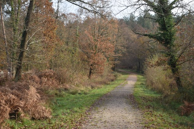
Hazel Copse, located in Hampshire, England, is a captivating woodland area that offers a peaceful and enchanting escape from the bustling city life. Spanning over a vast area, this dense forest is renowned for its abundant hazel trees, which give the copse its name. The copse is nestled within a rural landscape, surrounded by rolling hills and picturesque countryside.

The hazel trees that dominate the copse create a dense canopy, casting dappled sunlight onto the forest floor. This creates a magical ambiance, especially during the spring and summer months when the woodland is alive with vibrant hues of green. The copse is also home to a variety of other tree species, including oak, beech, and birch, which contribute to the rich biodiversity of the area.

As visitors explore the woodland trails that wind through Hazel Copse, they are likely to encounter an array of wildlife. The copse provides a habitat for a diverse range of species, including deer, squirrels, and numerous bird species. It is not uncommon to catch a glimpse of a fox darting through the undergrowth or to hear the melodic chirping of birdsong overhead.

Hazel Copse is a popular destination for nature enthusiasts and hikers alike. The well-maintained footpaths offer a chance to immerse oneself in the peaceful surroundings and admire the natural beauty of the forest. Whether visitors are seeking a tranquil stroll or a more challenging hike, Hazel Copse provides a serene environment that is sure to leave a lasting impression.

If you have any feedback on the listing, please let us know in the comments section below.

Hazel Copse Images

Images are sourced within 2km of 50.960904/-1.4294692 or Grid Reference SU4018. Thanks to Geograph Open Source API. All images are credited.

Signage on M27 - southbound
Gantry - M27 southbound
Rownhams Lane bridge - M27 southbound
Show homes at Broadleaf Park The show homes and sales office that will one day become plain 2 and 4 Harrison Way.
Show homes at Broadleaf Park
The show homes and sales office that will one day become plain 2 and 4 Harrison Way.
New homes under construction, Harrison Way, Rownhams Part of the Broadleaf Park development.
New homes under construction, Harrison Way, Rownhams
Part of the Broadleaf Park development.
Footpath south of Routs Copse This path runs along a small valley to the north of a new housing development, starting at the point where <a href="https://www.geograph.org.uk/photo/7274377">SU3817 : Show homes at Broadleaf Park</a> was taken.
Footpath south of Routs Copse
This path runs along a small valley to the north of a new housing development, starting at the point where SU3817 : Show homes at Broadleaf Park was taken.
Sunlit footpath at Matthew's Moor
Bridleway through Lord's Wood The woodland has given its name to the adjacent Southampton neighbourhood of Lordswood.
Bridleway through Lord's Wood
The woodland has given its name to the adjacent Southampton neighbourhood of Lordswood.
Bridleway from Rownhams to Lordswood
Track into Dymer's Wood
Autumn morning at Lavington Gardens Playing Field
Track entering Rownhams Plantation
Track descending towards stream in Rownhams Plantation
New tree planting in Rownhams Plantation
Beside the path, Rownhams Plantation
Newly landscaped exercise area beside Harrison Way
Looking up to Snowden Close Recently-completed cul-de-sac on the Broadleaf Park housing development.
Looking up to Snowden Close
Recently-completed cul-de-sac on the Broadleaf Park housing development.
Newly-completed housefronts, Snowden Close On the Broadleaf Park housing development.
Newly-completed housefronts, Snowden Close
On the Broadleaf Park housing development.
Show me another place!

Hazel Copse is located at Grid Ref: SU4018 (Lat: 50.960904, Lng: -1.4294692)

Administrative County: Hampshire

District: Test Valley

Police Authority: Hampshire

What 3 Words

///dupe.greed.wacky. Near North Baddesley, Hampshire

Related Wikis

Chilworth, Hampshire

Chilworth is a village in the Test Valley district of Hampshire, England, on the northern edge of Southampton. Good travel connections and restricted development...

Rownhams services

Rownhams services is a motorway service station on the M27 motorway, close to the junction for the M271 motorway which leads into Southampton. It is owned...

Chilworth Ring

Chilworth Ring is the site of a small univallate Iron Age hillfort located in Hampshire. Partial excavations of the site were carried out in 1928. The...

Southampton Municipal Golf Course

Southampton Municipal Golf Course is a 27-hole golf course in Southampton, England. The par 70, 6174yd, 18-hole course is set in mature parkland. It is...

Lordshill

Lordshill is a district in Southampton, England. It is situated in the northern part of the city. == History of Lordshill == According to the Anglo-Saxon...

North Baddesley

North Baddesley is a large village and civil parish in Hampshire, England. It is situated 3 mi (5 km) east of the town of Romsey and 6 mi (10 km) north...

Lordswood, Southampton

Lordswood is a district in Hampshire, England. It is situated in the northern quarter of greater Southampton bordering the areas of Lordshill, Chilworth...

Toothill Fort

Toothill Fort, or Toothill Ring, or Toothill camp, is the site of an Iron Age univallate hill fort located in Hampshire. The site occupies an extremely...

Nearby Amenities

Located within 500m of 50.960904,-1.4294692
Motorway Junction
Chilworth
Ref: 4
Lat/Long: 50.9597357/-1.424176
Traffic Calming: table
Lat/Long: 50.9613812/-1.4325322
Post Box
Note: position slightly approximate
Ref: SO16 731
Lat/Long: 50.96233/-1.4241353
Traffic Calming: table
Lat/Long: 50.9616928/-1.4315281
Cafe
Lattes
Addr City: Southampton
Addr Country: GB
Addr Housenumber: 2
Addr Postcode: SO16 7NP
Addr Street: Venture Road
Cuisine: coffee_shop
Fhrs Id: 30161
Opening Hours: Mo-Fr 08:00-16:30
Website: https://www.science-park.co.uk/park-amenities/lattes-coffee-shop
Lat/Long: 50.9613388/-1.422739
Bicycle Parking
Lat/Long: 50.9613241/-1.4251959
Bicycle Parking
Lat/Long: 50.9610884/-1.4250738
Leisure: picnic_table
Lat/Long: 50.9611585/-1.4250551
Leisure: picnic_table
Lat/Long: 50.9612709/-1.4251087
Leisure: picnic_table
Lat/Long: 50.9611442/-1.4259745
Leisure: picnic_table
Lat/Long: 50.9609975/-1.4257897
Bus Stop
Bus: yes
Naptan AtcoCode: 1900HAA91511
Naptan NaptanCode: hamjtjag
Naptan Street: Enterprise Road
Public Transport: platform
Lat/Long: 50.9621598/-1.4262165
Cafe
Fusion
Opening Hours: Mo-Fr 08:30-14:30
Lat/Long: 50.9621525/-1.4302988
Ford: yes
Lat/Long: 50.9579493/-1.4333673
Ford: yes
Lat/Long: 50.9577435/-1.4337228
Communication Television: yes
Description: Sky uplink transmitter
Man Made: mast
Tower Construction: dish
Tower Type: communication
Lat/Long: 50.9611139/-1.4282247
Communication Television: yes
Man Made: mast
Tower Construction: dish
Tower Type: communication
Lat/Long: 50.9610895/-1.4279774
Communication Television: yes
Man Made: mast
Tower Construction: dish
Tower Type: communication
Lat/Long: 50.9611333/-1.4278218
Communication Television: yes
Man Made: mast
Tower Construction: dish
Tower Type: communication
Lat/Long: 50.9610191/-1.4274076
Communication Television: yes
Man Made: mast
Tower Construction: dish
Tower Type: communication
Lat/Long: 50.9608757/-1.427123
Communication Television: yes
Man Made: mast
Tower Construction: dish
Tower Type: communication
Lat/Long: 50.960845/-1.4276759
Communication Television: yes
Man Made: mast
Tower Construction: dish
Tower Type: communication
Lat/Long: 50.960797/-1.4277806
Communication Television: yes
Man Made: mast
Tower Construction: dish
Tower Type: communication
Lat/Long: 50.9609486/-1.4272252
Communication Television: yes
Man Made: mast
Tower Construction: dish
Tower Type: communication
Lat/Long: 50.9605178/-1.4265252
Communication Television: yes
Man Made: mast
Tower Construction: dish
Tower Type: communication
Lat/Long: 50.9606242/-1.4264179
Communication Television: yes
Description: Sky uplink transmitter
Man Made: mast
Tower Construction: dish
Tower Type: communication
Lat/Long: 50.9611687/-1.4286863
Communication Television: yes
Description: Sky uplink transmitter
Man Made: mast
Tower Construction: dish
Tower Type: communication
Lat/Long: 50.9611662/-1.4286427
Communication Television: yes
Description: Sky uplink transmitter
Man Made: mast
Tower Construction: dish
Tower Type: communication
Lat/Long: 50.9611662/-1.4285837
Communication Television: yes
Description: Sky uplink transmitter
Man Made: mast
Tower Construction: dish
Tower Type: communication
Lat/Long: 50.9611666/-1.428524
Communication Television: yes
Description: Sky uplink transmitter
Man Made: mast
Tower Construction: dish
Tower Type: communication
Lat/Long: 50.9611484/-1.4284624
Communication Television: yes
Description: Sky uplink transmitter
Man Made: mast
Tower Construction: dish
Tower Type: communication
Lat/Long: 50.9611299/-1.428522
Communication Television: yes
Description: Sky uplink transmitter
Man Made: mast
Tower Construction: dish
Tower Type: communication
Lat/Long: 50.9611265/-1.428577
Communication Television: yes
Description: Sky uplink transmitter
Man Made: mast
Tower Construction: dish
Tower Type: communication
Lat/Long: 50.9611277/-1.428626
Communication Television: yes
Description: Sky uplink transmitter
Man Made: mast
Tower Construction: dish
Tower Type: communication
Lat/Long: 50.9611286/-1.4286649
Communication Television: yes
Description: Sky uplink transmitter
Man Made: mast
Tower Construction: dish
Tower Type: communication
Lat/Long: 50.9611282/-1.4287051
Fresh Relevance
Addr Housenumber: 5
Addr Postcode: SO16 7QJ
Addr Street: Benham Road
Level: 1
Office: company
Lat/Long: 50.9623607/-1.4304663
Ford: yes
Lat/Long: 50.9617133/-1.4353568
Matthew's Moor
Place: locality
Lat/Long: 50.9589378/-1.4319554
Golf: pin
Lat/Long: 50.9644126/-1.4301978
Golf: pin
Lat/Long: 50.9641822/-1.4322265
Ford: yes
Lat/Long: 50.9581192/-1.4347349
Bicycle Parking
Bicycle Parking: stands
Capacity: 8
Covered: no
Fee: no
Lat/Long: 50.9612412/-1.422844
Bus Stop
Bus: yes
Public Transport: platform
Lat/Long: 50.9620035/-1.4308535
Crossing
Lat/Long: 50.9615393/-1.4322614
Traffic Calming: table
Lat/Long: 50.962008/-1.4304918
Traffic Calming: hump
Lat/Long: 50.9618903/-1.4228563
Traffic Calming: hump
Lat/Long: 50.9623712/-1.4256371
Traffic Calming: table
Lat/Long: 50.9622457/-1.4268505
Traffic Calming: table
Lat/Long: 50.9618614/-1.4258185
Crossing
Lat/Long: 50.9619028/-1.4288894
Ford: yes
Lat/Long: 50.96329/-1.4322569
Ford: yes
Lat/Long: 50.9630528/-1.4334742
Ford: yes
Lat/Long: 50.9625193/-1.4312167
Ford: yes
Lat/Long: 50.9629066/-1.4337666
The data included in this document is from www.openstreetmap.org. The data is made available under ODbL.

Have you been to Hazel Copse?

Leave your review of Hazel Copse below (or comments, questions and feedback).