Butterwick Plantation

Wood, Forest in Durham

England

Butterwick Plantation

Derelict filling station on north side of A689 The old petrol station was clearly a modest affair by modern standards, having just a tiny forecourt. It has been disused for some time - even seven year's earlier, Pauline's image shows the building to be in a poor state <a title="https://www.geograph.org.uk/photo/4015894" href="https://www.geograph.org.uk/photo/4015894">Link</a> .
Derelict filling station on north side of A689 Credit: Trevor Littlewood

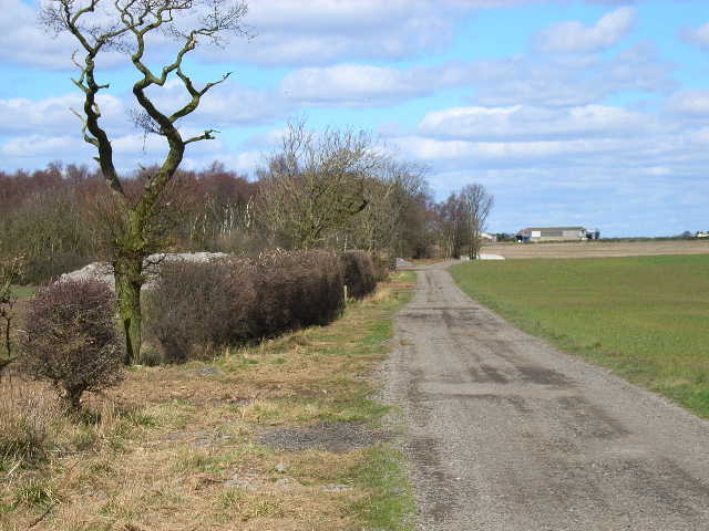
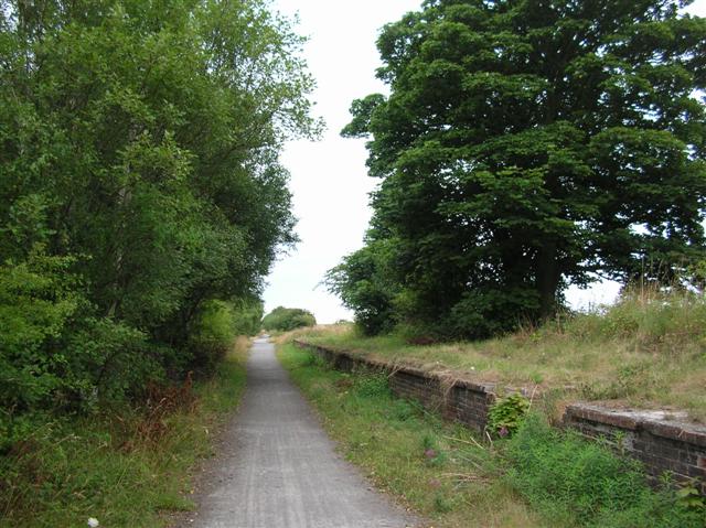
Butterwick Plantation is a historic woodland located in Durham, England. Situated in the heart of the county, it encompasses a vast area of lush greenery and ancient trees, making it a popular destination for nature enthusiasts and history buffs alike.

The plantation is believed to have originated in the medieval period, with records dating back to the 13th century. It was originally established as a hunting ground for the local nobility, and its name is derived from the Old English word for "butter farm," suggesting that it may have once been a site for dairy production.

Today, Butterwick Plantation is managed by the local council as a designated nature reserve and forest park. It offers visitors a tranquil escape from the hustle and bustle of urban life, with numerous walking trails and picnic areas scattered throughout the woodland.

The plantation is home to a diverse range of flora and fauna, including native tree species such as oak, ash, and beech, as well as a variety of wildflowers and ferns. It is also a sanctuary for various woodland animals, including deer, squirrels, and a wide array of bird species.

In addition to its natural beauty, Butterwick Plantation also boasts several historical features. These include the remnants of an ancient deer park, as well as the ruins of a medieval hunting lodge. These remnants serve as a reminder of the area's rich history and its importance as a hunting ground for the local aristocracy.

Overall, Butterwick Plantation is a treasured natural and historical gem in Durham. Its combination of ancient woodlands, wildlife, and historical features make it a must-visit destination for anyone looking to explore the beauty and heritage of the region.

If you have any feedback on the listing, please let us know in the comments section below.

Butterwick Plantation Images

Images are sourced within 2km of 54.670728/-1.3937609 or Grid Reference NZ3930. Thanks to Geograph Open Source API. All images are credited.

Derelict filling station on north side of A689 The old petrol station was clearly a modest affair by modern standards, having just a tiny forecourt. It has been disused for some time - even seven year's earlier, Pauline's image shows the building to be in a poor state <a title="https://www.geograph.org.uk/photo/4015894" href="https://www.geograph.org.uk/photo/4015894">Link</a> .
Derelict filling station on north side of A689
The old petrol station was clearly a modest affair by modern standards, having just a tiny forecourt. It has been disused for some time - even seven year's earlier, Pauline's image shows the building to be in a poor state Link .
Salter's Lane The lane provides access to Humble Knowle Farm, and is also a bridleway that extends beyond the farm.
Salter's Lane
The lane provides access to Humble Knowle Farm, and is also a bridleway that extends beyond the farm.
Ploughed Field Beside Salter's Lane Early Autumn farmland, with Butterwick Moor wind farm in the distance.
Ploughed Field Beside Salter's Lane
Early Autumn farmland, with Butterwick Moor wind farm in the distance.
Footpath Across Billy Jeans Campsite Billy Jeans Campsite offers basic field camping facilities next to a farm. The campsite was closed for the 2021 season, according to the business's social media page the campsite plans to re-open in summer 2022.
Footpath Across Billy Jeans Campsite
Billy Jeans Campsite offers basic field camping facilities next to a farm. The campsite was closed for the 2021 season, according to the business's social media page the campsite plans to re-open in summer 2022.
Humble Knowle Plantation A small area of planted woodland near Humble Knowle Farm.
Humble Knowle Plantation
A small area of planted woodland near Humble Knowle Farm.
Farm road and bridleway to Humble Knowle Farm, Fishburn
Former pub near Fishburn, County Durham Shown on the OS maps as a PH - but obviously no longer. 
It was previously the Three Horse Shoes Inn for some 220 years.
Former pub near Fishburn, County Durham
Shown on the OS maps as a PH - but obviously no longer. It was previously the Three Horse Shoes Inn for some 220 years.
Poultry houses at Little Butterwick Farm
Bridleway near Humble Knowe Farm A very superior bridleway with hard surface
Bridleway near Humble Knowe Farm
A very superior bridleway with hard surface
Humble Knowe Farm
Humble Knowe Farm
Entering County Durham on the A689 Leaving Teesside
Entering County Durham on the A689
Leaving Teesside
A689 road linking A1(north) with Teesside The dual carriageway has recently been extended over this section and a cycle path incorporated on the south side (right hand side of this picture)
A689 road linking A1(north) with Teesside
The dual carriageway has recently been extended over this section and a cycle path incorporated on the south side (right hand side of this picture)
Ten O'Clock Farm
Ten O'Clock Farm
Farm road from Butterwick Moor Farm
Farm road to Butterwick Moor Farm
Bridleway to the north of Butterwick Moor Farm Formed by rolling a strip over a field of winter-sown crops. A dreadful glutinous muddy passage.
Bridleway to the north of Butterwick Moor Farm
Formed by rolling a strip over a field of winter-sown crops. A dreadful glutinous muddy passage.
Butterwick Moor Farm
Butterwick House Farm, near Sedgefield
Show me another place!

Butterwick Plantation is located at Grid Ref: NZ3930 (Lat: 54.670728, Lng: -1.3937609)

Unitary Authority: County Durham

Police Authority: Durham

What 3 Words

///betrayal.forgot.skies. Near Fishburn, Co. Durham

Related Wikis

Butterwick, County Durham

Butterwick is a small village in County Durham, England. It is situated a short distance to the south east of Fishburn. Butterwick is first mentioned in...

Wynyard railway station (England)

Wynyard railway station was a railway station on the Castle Eden branch of the North Eastern Railway (NER) from 1880 to 1931. It was located immediately...

Hurworth Burn railway station

Hurworth Burn railway station was a railway station on the Castle Eden branch of the North Eastern Railway (NER) from 1880 to 1931. It was located between...

Fishburn

Fishburn is a village and civil parish in County Durham, in England. It is situated about 12 miles west of Hartlepool. It had a population of 2,454, increasing...

Nearby Amenities

Located within 500m of 54.670728,-1.3937609
Butterwick Moor
Generator Method: wind_turbine
Generator Output Electricity: yes
Generator Source: wind
Generator Type: horizontal_axis
Power: generator
Lat/Long: 54.6724851/-1.3884839
Butterwick Moor
Generator Method: wind_turbine
Generator Output Electricity: yes
Generator Source: wind
Generator Type: horizontal_axis
Power: generator
Lat/Long: 54.6725406/-1.3933623
Butterwick Moor
Generator Method: wind_turbine
Generator Output Electricity: yes
Generator Source: wind
Generator Type: horizontal_axis
Power: generator
Lat/Long: 54.6706611/-1.3972493
Butterwick Moor
Generator Method: wind_turbine
Generator Output Electricity: yes
Generator Source: wind
Generator Type: horizontal_axis
Power: generator
Lat/Long: 54.6700841/-1.3886984
Power: pole
Lat/Long: 54.670183/-1.400785
Power: pole
Lat/Long: 54.6707406/-1.3997389
Power: pole
Lat/Long: 54.6712866/-1.3987277
Power: pole
Lat/Long: 54.6720698/-1.3972418
Power: pole
Lat/Long: 54.6724165/-1.3966383
Power: pole
Lat/Long: 54.6734339/-1.3971224
Power: pole
Lat/Long: 54.6741024/-1.3973048
The data included in this document is from www.openstreetmap.org. The data is made available under ODbL.

Have you been to Butterwick Plantation?

Leave your review of Butterwick Plantation below (or comments, questions and feedback).