Stibbs Wood

Wood, Forest in Berkshire

England

Stibbs Wood

North Clapton Lane and Cottages near Winding Wood
North Clapton Credit: Chris Shaw

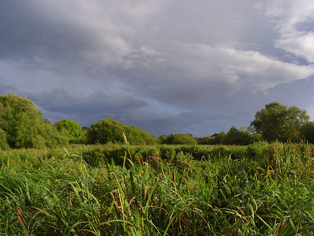
Stibbs Wood is a picturesque woodland located in Berkshire, England. Covering an area of approximately 200 acres, it is a popular destination for nature enthusiasts and outdoor lovers. The wood is situated near the village of Binfield, just a few miles away from the bustling town of Bracknell.

Stibbs Wood boasts a diverse range of tree species, including oak, beech, and birch, which create a stunning canopy of greenery. The woodland is also home to a variety of wildlife, such as deer, foxes, and an array of bird species, making it a perfect spot for birdwatching and wildlife spotting.

Visitors to Stibbs Wood can explore its many walking trails and footpaths, allowing them to immerse themselves in the natural beauty of the area. The wood is well-maintained, with clear signposts and information boards providing interesting facts about the local flora and fauna.

In addition to its natural beauty, Stibbs Wood offers recreational facilities for visitors to enjoy. There are designated picnic areas, perfect for a family outing or a peaceful lunch in the midst of nature. The wood also features a children's play area, ensuring that younger visitors have plenty of opportunities for fun and adventure.

Stibbs Wood is managed by the local council, ensuring its preservation and protection for future generations to enjoy. The wood provides a tranquil escape from the hustle and bustle of everyday life, offering visitors a chance to reconnect with nature and experience the beauty of Berkshire's woodlands.

If you have any feedback on the listing, please let us know in the comments section below.

Stibbs Wood Images

Images are sourced within 2km of 51.431457/-1.4717186 or Grid Reference SU3670. Thanks to Geograph Open Source API. All images are credited.

North Clapton Lane and Cottages near Winding Wood
North Clapton
Lane and Cottages near Winding Wood
Radley Farm Looking East to West across the square
Radley Farm
Looking East to West across the square
Heath Hanger Copse Viewed from the East
Heath Hanger Copse
Viewed from the East
Hungerford Newtown Church Near the junction with the A338 at the village centre.
Hungerford Newtown Church
Near the junction with the A338 at the village centre.
Hungerford Newtown Farmland Looking NE across farmland
Hungerford Newtown Farmland
Looking NE across farmland
Farmland, Hungerford Newtown The footpath crosses the western end of this field. It's the narrow stripe across the stubble.
Farmland, Hungerford Newtown
The footpath crosses the western end of this field. It's the narrow stripe across the stubble.
Farmland, Hungerford Newtown With Norbin's Wood on the right.
Farmland, Hungerford Newtown
With Norbin's Wood on the right.
Hare and trees in farmland, Wickham The trees are in a disused pit.
Hare and trees in farmland, Wickham
The trees are in a disused pit.
Farmland beside Wickfield Copse The trees on the left line Windingwood Lane as it approaches the copse.
Farmland beside Wickfield Copse
The trees on the left line Windingwood Lane as it approaches the copse.
Windingwood Bottom Looking across the top of the shallow valley from the southern end of Wickfield Copse.
Windingwood Bottom
Looking across the top of the shallow valley from the southern end of Wickfield Copse.
Pigs near Hungerford Newtown Pigs forage in the large field to the south of Norbin's Wood and west of Wickfield Copse.
Pigs near Hungerford Newtown
Pigs forage in the large field to the south of Norbin's Wood and west of Wickfield Copse.
Farmland, Hungerford Newtown Beside Dunkin's Copse to the north of Great Hidden Farm. The footpath runs to the right of the fence.
Farmland, Hungerford Newtown
Beside Dunkin's Copse to the north of Great Hidden Farm. The footpath runs to the right of the fence.
Hungerford Newtown A view across the village from the east. It sits in a valley that descends from Lambourn Woodlands to the Kennet at Kintbury.
Hungerford Newtown
A view across the village from the east. It sits in a valley that descends from Lambourn Woodlands to the Kennet at Kintbury.
Farmland and cottages, Clapton The cottages are just east of the road junction at the northern end of the hamlet. The field contains stubble.
Farmland and cottages, Clapton
The cottages are just east of the road junction at the northern end of the hamlet. The field contains stubble.
Footpath to Radley Farm The footpath passing alongside the edge of a copse shortly after having left the road from Clapton.
Footpath to Radley Farm
The footpath passing alongside the edge of a copse shortly after having left the road from Clapton.
Stibbs Wood, Radley The deciduous woodland is crossed by the public footpath west of Radley Farm. This is the view to the north. To the south are pheasant pens.
Stibbs Wood, Radley
The deciduous woodland is crossed by the public footpath west of Radley Farm. This is the view to the north. To the south are pheasant pens.
The Tally Ho and the A338, Hungerford Newtown A Wadworths pub at the village's crossroads.
The Tally Ho and the A338, Hungerford Newtown
A Wadworths pub at the village's crossroads.
St Mary, Hungerford Newtown Built in 1869.
St Mary, Hungerford Newtown
Built in 1869.
Show me another place!

Stibbs Wood is located at Grid Ref: SU3670 (Lat: 51.431457, Lng: -1.4717186)

Unitary Authority: West Berkshire

Police Authority: Thames Valley

What 3 Words

///bypasses.eliminate.soap. Near Wickham, Berkshire

Related Wikis

Upper Denford

Upper Denford is a hamlet in Berkshire, England, and part of the civil parish of Kintbury. The settlement lies north of the A4 road, and is located approximately...

Winding Wood, Berkshire

Winding Wood is a hamlet and a wood in the West Berkshire district, in the English county of Berkshire. It is south of the M4 motorway and north of the...

Kennet and Lambourn Floodplain

Kennet and Lambourn Floodplain is a 23.4-hectare (58-acre) biological Site of Special Scientific Interest in six widely separated areas in the floodplains...

Denford Park

Denford Park is a country house and surrounding estate in the English county of Berkshire, within the civil parish of Kintbury. The estate lies near to...

Hungerford police murders

On 11 December 1876, Inspector Joseph Drewitt and PC Thomas Shorter were murdered near Hungerford in Berkshire, United Kingdom. The officers were in the...
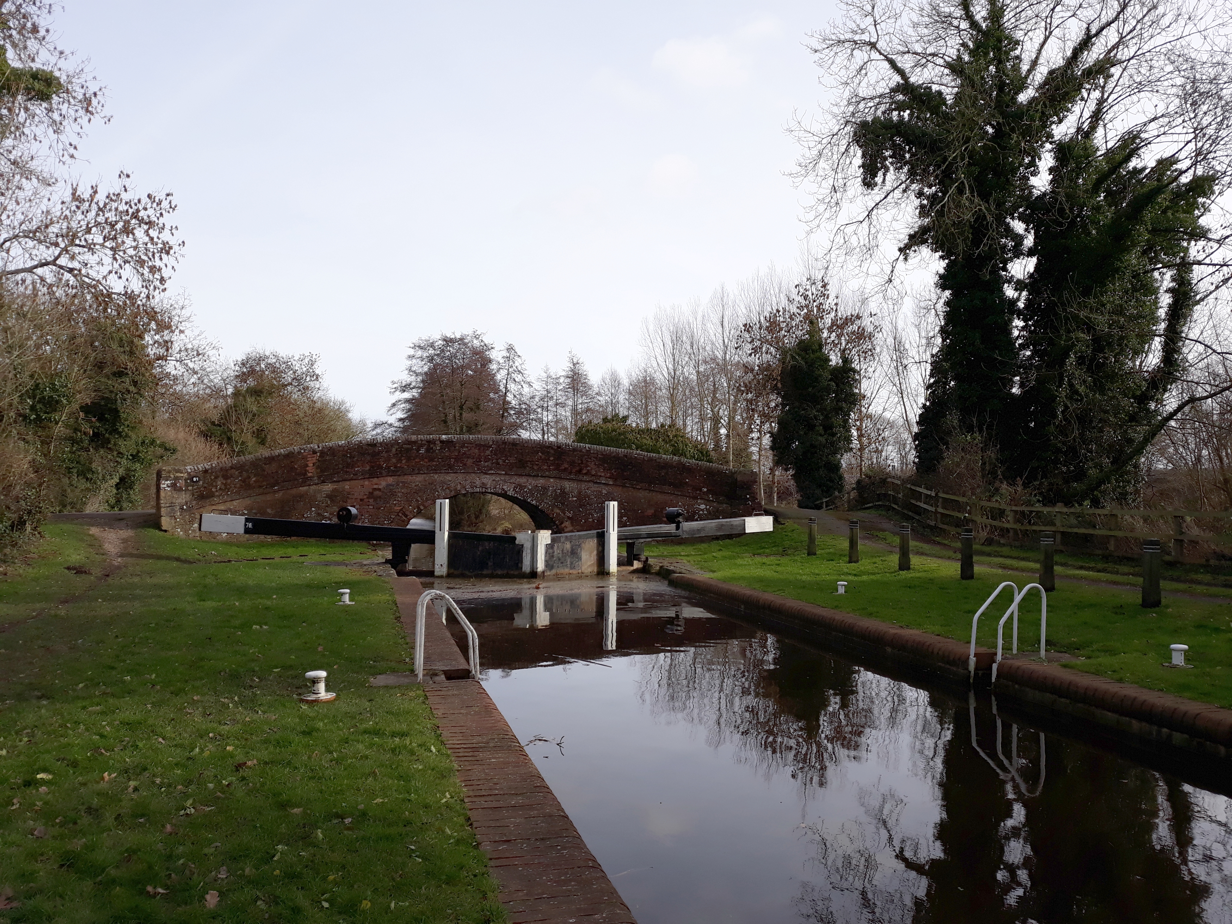
Wire Lock

Wire Lock is a lock on the Kennet and Avon Canal, near Hungerford, Berkshire, England. It is a grade II listed building. == References == == See also... ==

Lower Denford

Lower Denford is a hamlet in the civil parish of Kintbury in the English county of Berkshire. The settlement lies adjacent to the A4 road, and is located...

Avington, Berkshire

Avington is a village and former civil parish, now in the parish of Kintbury, in the West Berkshire district, in the ceremonial county of Berkshire, England...

Nearby Amenities

Located within 500m of 51.431457,-1.4717186
Radley Farm Airstrip
Addr City: Hungerford
Aeroway: aerodrome
Lat/Long: 51.43359/-1.4675519
Power: pole
Source: Bing
Lat/Long: 51.4277346/-1.4682439
Power: pole
Source: Bing
Lat/Long: 51.4282529/-1.4672962
Power: pole
Source: Bing
Lat/Long: 51.4287376/-1.4664025
Power: pole
Source: Bing
Lat/Long: 51.4292802/-1.4654713
Power: pole
Source: Bing
Lat/Long: 51.4312833/-1.4653188
The data included in this document is from www.openstreetmap.org. The data is made available under ODbL.

Have you been to Stibbs Wood?

Leave your review of Stibbs Wood below (or comments, questions and feedback).