Bendalls Clump

Wood, Forest in Derbyshire South Derbyshire

England

Bendalls Clump

Overgrown stile beside the National Forest Way
Overgrown stile beside the National Forest Way Credit: David Lally

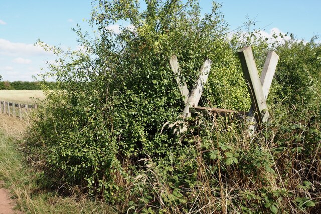
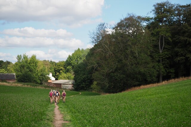
Bendalls Clump is a small woodland area located in Derbyshire, England. Situated near the village of Bonsall, it is a popular destination for nature enthusiasts and hikers alike. The clump covers an area of approximately 20 acres and is known for its diverse range of plant and animal species.

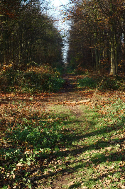
The woodland is predominantly composed of native broadleaf trees, such as oak, beech, and ash. These trees provide a lush canopy that creates a cool and shaded environment, perfect for a leisurely stroll on a warm summer's day. Bluebells carpet the forest floor in the spring, creating a stunning display of vibrant colors.

Bendalls Clump is home to a variety of wildlife, making it a haven for animal lovers. Visitors may spot various bird species, including woodpeckers, owls, and jays. Squirrels scamper through the trees, while rabbits and foxes can occasionally be seen darting between the undergrowth. The clump also attracts a diverse range of insect life, with butterflies and dragonflies fluttering through the air.

The woodland is crisscrossed with a network of well-maintained footpaths, allowing visitors to explore the area at their own pace. These paths wind through the trees, occasionally opening up to reveal panoramic views of the surrounding countryside. The clump is also located near several other nature reserves and walking trails, offering the opportunity for longer hikes and exploration of the wider area.

Overall, Bendalls Clump is a picturesque woodland retreat, offering a tranquil escape from the hustle and bustle of everyday life. Whether it's for a peaceful walk, birdwatching, or simply immersing oneself in nature, this enchanting forest is a must-visit destination in Derbyshire.

If you have any feedback on the listing, please let us know in the comments section below.

Bendalls Clump Images

Images are sourced within 2km of 52.830466/-1.5032434 or Grid Reference SK3325. Thanks to Geograph Open Source API. All images are credited.

Overgrown stile beside the National Forest Way
Harvested wheat field Still showing the machinery track lines.
Harvested wheat field
Still showing the machinery track lines.
View toward Bendalls Clump
Rough shelter In a small wood near Formark, and beside the National Forest Way.
Rough shelter
In a small wood near Formark, and beside the National Forest Way.
Path near Formark With a group of naturist ramblers.
Path near Formark
With a group of naturist ramblers.
Footpath or not? There appears to be the remnant of a stile here and a gap in the hedge.  According to the map however there's no public footpath through there.  The sign is correctly indicating the right of way along the track from which this was taken.
Footpath or not?
There appears to be the remnant of a stile here and a gap in the hedge. According to the map however there's no public footpath through there. The sign is correctly indicating the right of way along the track from which this was taken.
Straw bale
Straw bale
The Lake at Formark Hall
Track near Formark Hall
Gate on the edge of Heath Wood A Forestry Commission wood of mixed deciduous trees.
Gate on the edge of Heath Wood
A Forestry Commission wood of mixed deciduous trees.
Path in Heath Wood A forestry Commission wood of mixed deciduous trees.
Path in Heath Wood
A forestry Commission wood of mixed deciduous trees.
Gate on the edge of Heath Wood A Forestry Commission wood of mixed deciduous trees.
Gate on the edge of Heath Wood
A Forestry Commission wood of mixed deciduous trees.
Anchor Church Caves Anchor Church is the name given to a series of caves in a Keuper Sandstone (Triassic conglomerate) outcrop, close to the village of Ingleby, The caves have been extended by human intervention to form a crude dwelling place, complete with door and window holes.

The sandstone outcrop once formed part of the banks of the River Trent and the caves were formed by the action of the river on the rock.

The name Anchor Church is derived from the term anchorite (from the Greek to withdraw or to depart into the countryside) because it is thought to have been the cell of an Anchorite hermit, St Hardulph (also known as Eardwulf of Northumbria, a deposed king of Northumbria who died in AD830) who lived and prayed here in the 8th and 9th century.

In the Middle Ages, the caves were used by a monk named Bernard, who died here whilst doing penance for his involvement in some unknown crime. Records of the caves exist from 1658 when it is mentioned in Repton church records.

The Burdett family of Foremarke Hall enlarged the caves to the present size in the 18th century, fitting a door in 1845 and some additional brickwork, including a set of steps to the main entrance. Sir Francis Burdett used the caves as a summerhouse and held picnics there.

<span class="nowrap"><a title="https://en.wikipedia.org/wiki/Anchor_Church" rel="nofollow ugc noopener" href="https://en.wikipedia.org/wiki/Anchor_Church">Link</a><img style="margin-left:2px;" alt="External link" title="External link - shift click to open in new window" src="https://s1.geograph.org.uk/img/external.png" width="10" height="10"/></span>
Anchor Church Caves
Anchor Church is the name given to a series of caves in a Keuper Sandstone (Triassic conglomerate) outcrop, close to the village of Ingleby, The caves have been extended by human intervention to form a crude dwelling place, complete with door and window holes. The sandstone outcrop once formed part of the banks of the River Trent and the caves were formed by the action of the river on the rock. The name Anchor Church is derived from the term anchorite (from the Greek to withdraw or to depart into the countryside) because it is thought to have been the cell of an Anchorite hermit, St Hardulph (also known as Eardwulf of Northumbria, a deposed king of Northumbria who died in AD830) who lived and prayed here in the 8th and 9th century. In the Middle Ages, the caves were used by a monk named Bernard, who died here whilst doing penance for his involvement in some unknown crime. Records of the caves exist from 1658 when it is mentioned in Repton church records. The Burdett family of Foremarke Hall enlarged the caves to the present size in the 18th century, fitting a door in 1845 and some additional brickwork, including a set of steps to the main entrance. Sir Francis Burdett used the caves as a summerhouse and held picnics there. LinkExternal link
Anchor Church Caves Inside Anchor Church is the name given to a series of caves in a Keuper Sandstone (Triassic conglomerate) outcrop, close to the village of Ingleby, The caves have been extended by human intervention to form a crude dwelling place, complete with door and window holes.

The sandstone outcrop once formed part of the banks of the River Trent and the caves were formed by the action of the river on the rock.

The name Anchor Church is derived from the term anchorite (from the Greek to withdraw or to depart into the countryside) because it is thought to have been the cell of an Anchorite hermit, St Hardulph (also known as Eardwulf of Northumbria, a deposed king of Northumbria who died in AD830) who lived and prayed here in the 8th and 9th century.

In the Middle Ages, the caves were used by a monk named Bernard, who died here whilst doing penance for his involvement in some unknown crime. Records of the caves exist from 1658 when it is mentioned in Repton church records.

The Burdett family of Foremarke Hall enlarged the caves to the present size in the 18th century, fitting a door in 1845 and some additional brickwork, including a set of steps to the main entrance. Sir Francis Burdett used the caves as a summerhouse and held picnics there.

<span class="nowrap"><a title="https://en.wikipedia.org/wiki/Anchor_Church" rel="nofollow ugc noopener" href="https://en.wikipedia.org/wiki/Anchor_Church">Link</a><img style="margin-left:2px;" alt="External link" title="External link - shift click to open in new window" src="https://s1.geograph.org.uk/img/external.png" width="10" height="10"/></span>
Anchor Church Caves Inside
Anchor Church is the name given to a series of caves in a Keuper Sandstone (Triassic conglomerate) outcrop, close to the village of Ingleby, The caves have been extended by human intervention to form a crude dwelling place, complete with door and window holes. The sandstone outcrop once formed part of the banks of the River Trent and the caves were formed by the action of the river on the rock. The name Anchor Church is derived from the term anchorite (from the Greek to withdraw or to depart into the countryside) because it is thought to have been the cell of an Anchorite hermit, St Hardulph (also known as Eardwulf of Northumbria, a deposed king of Northumbria who died in AD830) who lived and prayed here in the 8th and 9th century. In the Middle Ages, the caves were used by a monk named Bernard, who died here whilst doing penance for his involvement in some unknown crime. Records of the caves exist from 1658 when it is mentioned in Repton church records. The Burdett family of Foremarke Hall enlarged the caves to the present size in the 18th century, fitting a door in 1845 and some additional brickwork, including a set of steps to the main entrance. Sir Francis Burdett used the caves as a summerhouse and held picnics there. LinkExternal link
Road running north-east from Milton The wall on the left has a base of stone, topped with bricks.  Opposite, the house also has a stone base to the end wall
Road running north-east from Milton
The wall on the left has a base of stone, topped with bricks. Opposite, the house also has a stone base to the end wall
Fields north of Orange Hill, near Milton
Hedges and fields north of Orange Hill The nearer hedges are on the edge of a small stream
Hedges and fields north of Orange Hill
The nearer hedges are on the edge of a small stream
Show me another place!

Bendalls Clump is located at Grid Ref: SK3325 (Lat: 52.830466, Lng: -1.5032434)

Administrative County: Derbyshire

District: South Derbyshire

Police Authority: Derbyshire

What 3 Words

///fictional.earth.lurching. Near Repton, Derbyshire

Nearby Locations

Bendalls Clump Foremark

Related Wikis

Repton Prep

Repton Prep (formally Repton Preparatory School) is a co-educational Private Preparatory School in Foremark, Derbyshire, England which caters for day and...

Foremarke Hall

Foremarke Hall is a Georgian-Palladian country house and manor house. Completed in 1762, the Hall is located at the manor (hamlet) of Foremark, near the...

Foremark

Foremark is a hamlet and civil parish in the South Derbyshire district of Derbyshire, England. It contains Foremarke Hall, a medieval manor house which...

St Saviour's Church, Foremark

St Saviour's Church, Foremark, is a Grade I listed parish church in the Church of England in Foremark, Derbyshire. == History == The church dates from...

Heath Wood barrow cemetery

Heath Wood barrow cemetery is a Viking burial site near Ingleby, Derbyshire. == Description == Heath Wood contains a series of 59 barrows which is a Viking...
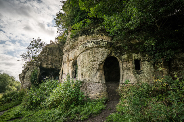
Anchor Church

Anchor Church is the name given to a series of caves in a Keuper Sandstone (Triassic conglomerate) outcrop, close to the village of Ingleby, Derbyshire...

Milton, Derbyshire

Milton is a hamlet 6 miles south-west of Derby and 1.5 miles east of Repton. Its population is around 200. It is thought to have been established by the...

Ingleby, Derbyshire

Ingleby is a hamlet and civil parish in South Derbyshire, England, situated to the south of the River Trent on a rise between Stanton by Bridge and Repton...

Nearby Amenities

Located within 500m of 52.830466,-1.5032434
Power: tower
Source: Bing
Lat/Long: 52.8265707/-1.5011077
The data included in this document is from www.openstreetmap.org. The data is made available under ODbL.

Have you been to Bendalls Clump?

Leave your review of Bendalls Clump below (or comments, questions and feedback).