The Island

Wood, Forest in Warwickshire Stratford-on-Avon

England

The Island

Listed cottage, Upper Tysoe The Thatched House <span class="nowrap"><a title="https://historicengland.org.uk/listing/the-list/list-entry/1186194?section=official-list-entry" rel="nofollow ugc noopener" href="https://historicengland.org.uk/listing/the-list/list-entry/1186194?section=official-list-entry">Link</a><img style="margin-left:2px;" alt="External link" title="External link - shift click to open in new window" src="https://s1.geograph.org.uk/img/external.png" width="10" height="10"/></span> is also shown at <a href="https://www.geograph.org.uk/photo/3025625">SP3343 : The Thatched House</a>.
Listed cottage, Upper Tysoe Credit: Derek Harper

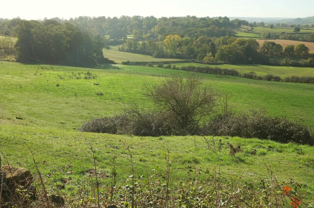
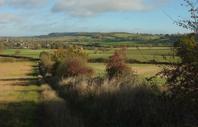
The Island, located in Warwickshire, is a charming wood and forest area that offers a serene and picturesque escape from the hustle and bustle of everyday life. Spread across approximately 20 acres of land, this natural haven is situated near the town of Warwick and is easily accessible by road.

The Island is renowned for its diverse range of flora and fauna, making it a popular destination for nature enthusiasts and wildlife lovers. The wood is predominantly composed of deciduous trees, including oak, ash, and birch, which create a vibrant and colorful landscape throughout the year. The forest floor is adorned with an array of wildflowers, providing a delightful sight during spring and summer.

Tranquil walking paths wind their way through the wood, inviting visitors to explore and discover the hidden gems within. The gentle rustling of leaves and the melodic chirping of birds create a soothing ambiance, perfect for relaxation and reflection. Numerous benches and picnic spots are scattered throughout the area, allowing visitors to pause and enjoy the natural beauty that surrounds them.

The Island is home to a variety of wildlife, including deer, foxes, and a wide range of bird species. Birdwatchers can spot woodpeckers, owls, and various songbirds, among others. The wood also contains a small lake, providing a habitat for ducks, geese, and other waterfowl.

Overall, The Island in Warwickshire offers a tranquil and enchanting experience for those seeking solace in nature. Its lush wood and forest, diverse wildlife, and serene atmosphere make it a must-visit destination for both locals and tourists alike.

If you have any feedback on the listing, please let us know in the comments section below.

The Island Images

Images are sourced within 2km of 52.089142/-1.5156143 or Grid Reference SP3343. Thanks to Geograph Open Source API. All images are credited.

Listed cottage, Upper Tysoe The Thatched House <span class="nowrap"><a title="https://historicengland.org.uk/listing/the-list/list-entry/1186194?section=official-list-entry" rel="nofollow ugc noopener" href="https://historicengland.org.uk/listing/the-list/list-entry/1186194?section=official-list-entry">Link</a><img style="margin-left:2px;" alt="External link" title="External link - shift click to open in new window" src="https://s1.geograph.org.uk/img/external.png" width="10" height="10"/></span> is also shown at <a href="https://www.geograph.org.uk/photo/3025625">SP3343 : The Thatched House</a>.
Listed cottage, Upper Tysoe
The Thatched House LinkExternal link is also shown at SP3343 : The Thatched House.
Postbox, Upper Tysoe Elizabeth II postbox CV35 116 seems to have been slightly repositioned since <a href="https://www.geograph.org.uk/photo/185583">SP3343 : Postbox, Upper Tysoe</a> was taken over 16 years earlier.
Postbox, Upper Tysoe
Elizabeth II postbox CV35 116 seems to have been slightly repositioned since SP3343 : Postbox, Upper Tysoe was taken over 16 years earlier.
Listed cottages, Upper Tysoe Green Cottage <span class="nowrap"><a title="https://historicengland.org.uk/listing/the-list/list-entry/1035497?section=official-list-entry" rel="nofollow ugc noopener" href="https://historicengland.org.uk/listing/the-list/list-entry/1035497?section=official-list-entry">Link</a><img style="margin-left:2px;" alt="External link" title="External link - shift click to open in new window" src="https://s1.geograph.org.uk/img/external.png" width="10" height="10"/></span> (right) and Brown Cottage <span class="nowrap"><a title="https://historicengland.org.uk/listing/the-list/list-entry/1364799?section=official-list-entry" rel="nofollow ugc noopener" href="https://historicengland.org.uk/listing/the-list/list-entry/1364799?section=official-list-entry">Link</a><img style="margin-left:2px;" alt="External link" title="External link - shift click to open in new window" src="https://s1.geograph.org.uk/img/external.png" width="10" height="10"/></span> are side by side on Shipston Road.
Listed cottages, Upper Tysoe
Green Cottage LinkExternal link (right) and Brown Cottage LinkExternal link are side by side on Shipston Road.
Tysoe Windmill <span class="nowrap"><a title="https://historicengland.org.uk/listing/the-list/list-entry/1364775?section=official-list-entry" rel="nofollow ugc noopener" href="https://historicengland.org.uk/listing/the-list/list-entry/1364775?section=official-list-entry">Link</a><img style="margin-left:2px;" alt="External link" title="External link - shift click to open in new window" src="https://s1.geograph.org.uk/img/external.png" width="10" height="10"/></span> . The C18 mill is "Polygonal, tapering towards top". See also <a title="https://www.geograph.org.uk/search.php?i=168965865" href="https://www.geograph.org.uk/search.php?i=168965865">Link</a> . Footpath 287 SS44/1 runs past.
Tysoe Windmill
LinkExternal link . The C18 mill is "Polygonal, tapering towards top". See also Link . Footpath 287 SS44/1 runs past.
Gate below Tysoe Windmill With a view to Upper and Middle Tysoe. This looks down the line of footpath 287 SS44/1, but in fact walkers use a kissing gate just off to the right.
Gate below Tysoe Windmill
With a view to Upper and Middle Tysoe. This looks down the line of footpath 287 SS44/1, but in fact walkers use a kissing gate just off to the right.
Tysoe Manor The grade II* listed manor is seen from Shipston Road. A description is at <span class="nowrap"><a title="https://historicengland.org.uk/listing/the-list/list-entry/1186224?section=official-list-entry" rel="nofollow ugc noopener" href="https://historicengland.org.uk/listing/the-list/list-entry/1186224?section=official-list-entry">Link</a><img style="margin-left:2px;" alt="External link" title="External link - shift click to open in new window" src="https://s1.geograph.org.uk/img/external.png" width="10" height="10"/></span> .
Tysoe Manor
The grade II* listed manor is seen from Shipston Road. A description is at LinkExternal link .
Tysoe Windmill Another view of the listed mill <span class="nowrap"><a title="https://historicengland.org.uk/listing/the-list/list-entry/1364775?section=official-list-entry" rel="nofollow ugc noopener" href="https://historicengland.org.uk/listing/the-list/list-entry/1364775?section=official-list-entry">Link</a><img style="margin-left:2px;" alt="External link" title="External link - shift click to open in new window" src="https://s1.geograph.org.uk/img/external.png" width="10" height="10"/></span> also shown at <a title="https://www.geograph.org.uk/search.php?i=168965865" href="https://www.geograph.org.uk/search.php?i=168965865">Link</a> . Footpath 287 SS44/1 runs past on this side.
Tysoe Windmill
Another view of the listed mill LinkExternal link also shown at Link . Footpath 287 SS44/1 runs past on this side.
Trees on Windmill Hill Just west of Tysoe Windmill.
Trees on Windmill Hill
Just west of Tysoe Windmill.
Towards Compton Wynyates From Windmill Hill.
Towards Compton Wynyates
From Windmill Hill.
West from Windmill Hill Looking right from close to where <a href="https://www.geograph.org.uk/photo/7335524">SP3342 : Towards Compton Wynyates</a> was taken. Idlicote Hill is in the distance.
West from Windmill Hill
Looking right from close to where SP3342 : Towards Compton Wynyates was taken. Idlicote Hill is in the distance.
Ruined barn near Compton Wynyates A view from Windmill Hill.
Ruined barn near Compton Wynyates
A view from Windmill Hill.
Wall and wood, Windmill Hill Looking right from <a href="https://www.geograph.org.uk/photo/7335595">SP3242 : Ruined barn near Compton Wynyates</a>. The trees also appear in <a href="https://www.geograph.org.uk/photo/7335223">SP3342 : Trees on Windmill Hill</a>.
Wall and wood, Windmill Hill
Looking right from SP3242 : Ruined barn near Compton Wynyates. The trees also appear in SP3342 : Trees on Windmill Hill.
East from Windmill Hill Towards Shenlow Hill.
East from Windmill Hill
Towards Shenlow Hill.
Tysoe from Windmill Hill Looking left from <a href="https://www.geograph.org.uk/photo/7335631">SP3342 : East from Windmill Hill</a> to Upper and Lower Tysoe. On the right is the wooded Cotswold scarp near Edgehill.
Tysoe from Windmill Hill
Looking left from SP3342 : East from Windmill Hill to Upper and Lower Tysoe. On the right is the wooded Cotswold scarp near Edgehill.
Farmland near Upper Tysoe This looks to the right from <a href="https://www.geograph.org.uk/photo/7335645">SP3343 : Tysoe from Windmill Hill</a> and left from <a href="https://www.geograph.org.uk/photo/7335631">SP3342 : East from Windmill Hill</a>. The farm beyond the curving field boundary is Hill Farm (there is another Hill Farm within a kilometre up the hill). The hills form part of the Cotswold scarp.
Farmland near Upper Tysoe
This looks to the right from SP3343 : Tysoe from Windmill Hill and left from SP3342 : East from Windmill Hill. The farm beyond the curving field boundary is Hill Farm (there is another Hill Farm within a kilometre up the hill). The hills form part of the Cotswold scarp.
View from Tysoe Windmill With the windmill's shadow on the left.
View from Tysoe Windmill
With the windmill's shadow on the left.
Descending Windmill Hill The gate on the left is shown in <a href="https://www.geograph.org.uk/photo/7335021">SP3342 : Gate below Tysoe Windmill</a>; the walker is approaching the kissing gate which is the route for footpath 287 SS44/1. The scene on the right is similar to <a href="https://www.geograph.org.uk/photo/7335695">SP3342 : Farmland near Upper Tysoe</a>. In the distance is the Cotswold scarp.
Descending Windmill Hill
The gate on the left is shown in SP3342 : Gate below Tysoe Windmill; the walker is approaching the kissing gate which is the route for footpath 287 SS44/1. The scene on the right is similar to SP3342 : Farmland near Upper Tysoe. In the distance is the Cotswold scarp.
Towards Upper Tysoe Taken descending footpath 287 SS44/1 as seen in <a href="https://www.geograph.org.uk/photo/7335021">SP3342 : Gate below Tysoe Windmill</a>, with red haws by the path. As with <a href="https://www.geograph.org.uk/photo/7335645">SP3343 : Tysoe from Windmill Hill</a>, beyond the village is the wooded Cotswold scarp near Edgehill.
Towards Upper Tysoe
Taken descending footpath 287 SS44/1 as seen in SP3342 : Gate below Tysoe Windmill, with red haws by the path. As with SP3343 : Tysoe from Windmill Hill, beyond the village is the wooded Cotswold scarp near Edgehill.
Show me another place!

The Island is located at Grid Ref: SP3343 (Lat: 52.089142, Lng: -1.5156143)

Administrative County: Warwickshire

District: Stratford-on-Avon

Police Authority: Warwickshire

What 3 Words

///playfully.carefully.topic. Near Lower Brailes, Warwickshire

Related Wikis

Tysoe

Tysoe is a civil parish in the Stratford-on-Avon District of Warwickshire, England. The parish is on the boundary with Oxfordshire, about 7+1⁄2 miles...

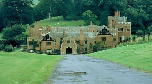
Compton Wynyates (parish)

Compton Wynyates or Compton Wyniates is an ancient parish and civil parish in Stratford-on-Avon District, Warwickshire, England. It includes the house...

Compton Wynyates

Compton Wynyates is a Tudor country house in Warwickshire, England, a Grade I listed building. The Tudor period house is constructed of red brick and built...

Red Horse of Tysoe

The Red Horse of Tysoe was a hill figure in the parish of Tysoe, South Warwickshire, England, cut into the red clay below the escarpment of Edgehill. It...

Oxhill, Warwickshire

Oxhill is a village in South Warwickshire, England, off the A422 road between Stratford-upon-Avon and Banbury. The population taken at the 2011 census...

Edge Hill, Warwickshire

Edge Hill is an escarpment and Edgehill a hamlet in the civil parish of Ratley and Upton, Stratford-on-Avon District, southern Warwickshire, England. At...

Whatcote

Whatcote is a village and civil parish in Warwickshire, England, about 4 miles (6.4 km) northeast of Shipston on Stour in the Vale of the Red Horse. The...

Epwell

Epwell is a village and civil parish in the north of Oxfordshire about 6 miles (10 km) west of Banbury. The 2011 Census recorded the parish population...

Nearby Amenities

Located within 500m of 52.089142,-1.5156143
Upper Tysoe
Place: village
Source: OS_OpenData_StreetView
Wikidata: Q55634143
Lat/Long: 52.0894733/-1.5084403
Barrier: stile
Lat/Long: 52.0924927/-1.5139826
Note: Flagpole
Lat/Long: 52.0903252/-1.5106998
Andersen Shelter
Lat/Long: 52.0905156/-1.5095419
Barrier: stile
Source: survey
Lat/Long: 52.0855287/-1.5114604
Barrier: stile
Source: survey
Lat/Long: 52.0885535/-1.5102537
Barrier: stile
Source: survey
Lat/Long: 52.0885843/-1.5101636
Barrier: stile
Source: survey
Lat/Long: 52.0887203/-1.5102346
Barrier: stile
Source: survey
Lat/Long: 52.0893759/-1.510028
Man Made: marker post
Source: visual survey;estimate
Lat/Long: 52.0882324/-1.5109932
Source: Warwicks Aerial Imagery OGLv2 2013
Lat/Long: 52.0920376/-1.5109727
Generator Method: photovoltaic
Generator Output Electricity: yes
Generator Source: solar
Generator Type: solar_photovoltaic_panel
Power: generator
Lat/Long: 52.0914784/-1.5101534
Generator Method: photovoltaic
Generator Output Electricity: yes
Generator Source: solar
Generator Type: solar_photovoltaic_panel
Power: generator
Lat/Long: 52.0922414/-1.510486
Generator Method: photovoltaic
Generator Output Electricity: yes
Generator Source: solar
Generator Type: solar_photovoltaic_panel
Location: roof
Power: generator
Lat/Long: 52.0901526/-1.513655
The data included in this document is from www.openstreetmap.org. The data is made available under ODbL.

Have you been to The Island?

Leave your review of The Island below (or comments, questions and feedback).