Grindon Lane Wood

Wood, Forest in Durham

England

Grindon Lane Wood

Great Stainton, All Saints church According to the OS benchmark database there is a benchmark cut into a supporting buttress. I was unable to find it.
Great Stainton, All Saints church Credit: Mel Towler

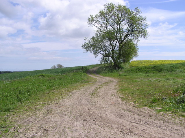
Grindon Lane Wood, located in Durham, is a picturesque and tranquil forest that offers visitors a serene escape from the bustling city life. Spanning approximately 20 acres, this wood is a haven for nature enthusiasts and provides an abundance of flora and fauna to explore.

The wood is predominantly made up of native broadleaf trees, including oak, beech, and birch, which create a dense canopy overhead. This dense foliage provides shelter for a variety of wildlife, such as deer, rabbits, and a multitude of bird species, making it an ideal spot for birdwatching and animal spotting.

A network of well-maintained footpaths winds its way through the wood, allowing visitors to explore its beauty at their own pace. These paths offer a mix of shaded areas, open clearings, and babbling brooks, creating a diverse and enchanting landscape. In spring, the forest floor comes alive with a vibrant carpet of wildflowers, adding a burst of color to the surroundings.

Grindon Lane Wood is also home to a small pond, which serves as a valuable habitat for amphibians and aquatic plants. Visitors can enjoy the peaceful ambiance of the pond while observing the resident frogs and newts.

The wood is managed by a dedicated team of conservationists who work to preserve its natural beauty and protect its wildlife. Educational programs and guided walks are often organized to raise awareness about the importance of conservation and to engage the local community in appreciating the wood's ecological significance.

Overall, Grindon Lane Wood is a hidden gem in Durham, offering a serene and enchanting woodland experience for nature lovers and those seeking a peaceful retreat in the heart of nature.

If you have any feedback on the listing, please let us know in the comments section below.

Grindon Lane Wood Images

Images are sourced within 2km of 54.599821/-1.5022216 or Grid Reference NZ3222. Thanks to Geograph Open Source API. All images are credited.

Great Stainton, All Saints church According to the OS benchmark database there is a benchmark cut into a supporting buttress. I was unable to find it.
Great Stainton, All Saints church
According to the OS benchmark database there is a benchmark cut into a supporting buttress. I was unable to find it.
Skerne valley
Skerne valley
Nissen huts, Preston Carrs This is a prefabricated steel structure made from a half-cylindrical skin of corrugated steel, was used extensively during World War II. Between April 16 and April 18, 1916, Major Peter Norman Nissen of the 29th Company Royal Engineers began to experiment with hut designs. Nissen, a mining engineer and inventor, constructed three prototype semi-cylindrical huts. The semi-cylindrical shape was derived from the drill-shed roof at Queen's University, Kingston, Ontario. Nissen’s design was subject to intensive review by his fellow officers, Lieutenant Colonels Shelly, Sewell and McDonald, and General Clive Gerard Liddell, which helped Nissen develop the design. After the third prototype was completed, the design was formalized and the Nissen hut was put into production in August 1916. At least 100,000 were produced in World War I
Nissen huts, Preston Carrs
This is a prefabricated steel structure made from a half-cylindrical skin of corrugated steel, was used extensively during World War II. Between April 16 and April 18, 1916, Major Peter Norman Nissen of the 29th Company Royal Engineers began to experiment with hut designs. Nissen, a mining engineer and inventor, constructed three prototype semi-cylindrical huts. The semi-cylindrical shape was derived from the drill-shed roof at Queen's University, Kingston, Ontario. Nissen’s design was subject to intensive review by his fellow officers, Lieutenant Colonels Shelly, Sewell and McDonald, and General Clive Gerard Liddell, which helped Nissen develop the design. After the third prototype was completed, the design was formalized and the Nissen hut was put into production in August 1916. At least 100,000 were produced in World War I
Railway underbridge at Preston le Skerne A rail underbridge on the disused Shildon to Newport line at the point where Leehall Lane meets Wildgoose Lane at Preston le Skerne
Railway underbridge at Preston le Skerne
A rail underbridge on the disused Shildon to Newport line at the point where Leehall Lane meets Wildgoose Lane at Preston le Skerne
Platelayer's hut near Preston le Skerne What was once a platelayer's hut next to the former Shildon to Newport Railway which was in remarkably good condition given its age.
Platelayer's hut near Preston le Skerne
What was once a platelayer's hut next to the former Shildon to Newport Railway which was in remarkably good condition given its age.
Wild Goose Lane near Preston le Skerne Following the bridleway east of Preston le Skerne it runs beside the former Shildon to Newport railway line. According to the OS map this is Wildgoose Lane, only there isn't a lane, just open fields.
Wild Goose Lane near Preston le Skerne
Following the bridleway east of Preston le Skerne it runs beside the former Shildon to Newport railway line. According to the OS map this is Wildgoose Lane, only there isn't a lane, just open fields.
Site of High Grindon medieval village. The high ground leading up to the trees on the skyline is the site of High Grindon medieval village of which there is no discernable sign today.
Site of High Grindon medieval village.
The high ground leading up to the trees on the skyline is the site of High Grindon medieval village of which there is no discernable sign today.
Grindon Lane This is a section of Grindon Lane north of Stainton Hill House in County Durham, which with its drainage ditches and seemingly raised roadbed intrigued me.
Grindon Lane
This is a section of Grindon Lane north of Stainton Hill House in County Durham, which with its drainage ditches and seemingly raised roadbed intrigued me.
Church The parish church of Great Stainton near Darlington
Church
The parish church of Great Stainton near Darlington
Barn and Arable Field, Off Lodge Lane
Great Stainton All Saints Church Viewed from the NW across the fields. An alternative name for Great Stainton is Stainton-le-Street, derived from its position on the old Roman road from Pountney's Bridge at Middleton St George to Durham.
Great Stainton All Saints Church
Viewed from the NW across the fields. An alternative name for Great Stainton is Stainton-le-Street, derived from its position on the old Roman road from Pountney's Bridge at Middleton St George to Durham.
Fir Tree Farm : Salters  Lane
Fir Tree Farm : Salters Lane
Viewley Hill  Farm South west of Great Stainton
Viewley Hill Farm
South west of Great Stainton
Kings Arms : Great Stainton.
Lane to Hauxley  Farm
Lane to Hauxley Farm
Grindon  Lane Green Lane to High Grindon Farm (demolished) looking south.
Grindon Lane
Green Lane to High Grindon Farm (demolished) looking south.
High Grindon : near Deserted Medieval Village There are remains of a medieval village with a number of earth banks and ditches forming small enclosures. A later farm house on the site now demolished.
High Grindon : near Deserted Medieval Village
There are remains of a medieval village with a number of earth banks and ditches forming small enclosures. A later farm house on the site now demolished.
Dismantled Railway  (Cutting) Part of the former Clarence Railway 1833. This stretch from Simpasture Junction to Stillington Junction. Electrified in 1915 by the NER.
Dismantled Railway (Cutting)
Part of the former Clarence Railway 1833. This stretch from Simpasture Junction to Stillington Junction. Electrified in 1915 by the NER.
Show me another place!

Grindon Lane Wood is located at Grid Ref: NZ3222 (Lat: 54.599821, Lng: -1.5022216)

Unitary Authority: County Durham

Police Authority: Durham

What 3 Words

///shadowing.star.lure. Near Coatham Mundeville, Co. Durham

Related Wikis

Preston-le-Skerne

Preston-le-Skerne is a hamlet in the civil parish of Mordon, County Durham, in England. It is situated a short distance to the east of Newton Aycliffe...

Newton Ketton Meadow

Newton Ketton Meadow is a Site of Special Scientific Interest in the Darlington district of Durham, England. It is situated alongside a small tributary...

Great Stainton

Great Stainton is a village in the borough of Darlington and ceremonial county of County Durham, England. It is situated to the north of Darlington, and...

Newton Ketton

Newton Ketton is a small village in County Durham, in England. It is situated to the north of Darlington. == External links == Media related to Newton...

Railway Stell West

Railway Stell West is a Site of Special Scientific Interest in the Sedgefield district of County Durham, England. The site consists of a length of ditch...

Brafferton, County Durham

Brafferton is a village and civil parish in County Durham, England. It is administered as part of the borough of Darlington. The population of Brafferton...

Aycliffe railway station

Aycliffe railway station served the village of Aycliffe in County Durham, England. The railway station was served by trains on the East Coast Main Line...

Mordon

Mordon is a village and civil parish in County Durham, England. It is situated a few miles to the north-east of Newton Aycliffe. The population recorded...

Nearby Amenities

Located within 500m of 54.599821,-1.5022216
Stainton Hill House
Place: locality
Source: OS OpenData StreetView
Lat/Long: 54.5961863/-1.5027254
The data included in this document is from www.openstreetmap.org. The data is made available under ODbL.

Have you been to Grindon Lane Wood?

Leave your review of Grindon Lane Wood below (or comments, questions and feedback).