Railway Wood

Wood, Forest in Durham

England

Railway Wood

Joe's Pond, Rainton Part of the Rainton Meadows Nature Reserve. A view in summer with lots of pondside vegetation.
Joe's Pond, Rainton Credit: Robert Graham

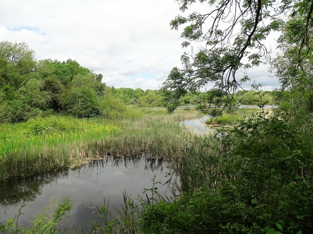
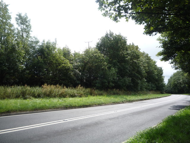
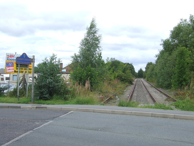
Railway Wood is a picturesque forest located in Durham, England. Covering an area of approximately 100 acres, it is a popular destination for nature enthusiasts and those seeking tranquility amidst the bustling city. The wood is named after the railway line that once ran through it, serving as a reminder of its historical significance.

The forest is predominantly composed of deciduous trees, including oak, beech, and ash, which provide a stunning display of colors during the autumn months. The dense foliage creates a serene and secluded atmosphere, making it an ideal spot for leisurely walks and picnics. Numerous well-maintained trails wind through the wood, allowing visitors to explore its beauty at their own pace.

Wildlife thrives in Railway Wood, with a diverse range of species calling it home. Birdwatchers will delight in spotting a variety of species, such as woodpeckers, owls, and songbirds. Squirrels can be seen darting between the trees, while occasional glimpses of deer add to the enchanting experience.

The wood also boasts a rich history, with remnants of the old railway line still visible. Rusting tracks and weathered signs serve as reminders of the area's past. This historical charm, combined with the natural beauty of the woodland, makes Railway Wood a unique and intriguing destination for visitors of all ages.

Managed by local authorities, Railway Wood offers facilities such as parking, picnic areas, and well-maintained paths. Whether one seeks a peaceful retreat, a chance to connect with nature, or a glimpse into the region's history, this enchanting forest provides a delightful experience for all who visit.

If you have any feedback on the listing, please let us know in the comments section below.

Railway Wood Images

Images are sourced within 2km of 54.842291/-1.5087575 or Grid Reference NZ3149. Thanks to Geograph Open Source API. All images are credited.

Joe's Pond, Rainton Part of the Rainton Meadows Nature Reserve. A view in summer with lots of pondside vegetation.
Joe's Pond, Rainton
Part of the Rainton Meadows Nature Reserve. A view in summer with lots of pondside vegetation.
Morton House 14th Durham VA Hospital in First World War.
Morton House
14th Durham VA Hospital in First World War.
Post Office Fencehouses
Naz Haven
Naz Haven
St Andrews Chilton Moor
House Front Street
House Front Street
N Power Building Rainton Bridge Ind Estate
Mercantile Road Entrance to the Industrial Estate
Mercantile Road
Entrance to the Industrial Estate
Joe's Pond This forms part of the large Rainton Meadows nature reserve, created in the early 2000's from an old colliery site.
Joe's Pond
This forms part of the large Rainton Meadows nature reserve, created in the early 2000's from an old colliery site.
Bird line up On Joe's Pond, Rainton Meadows Nature Reserve. From left to right these are: male Tufted Duck, male Gadwall, Coot and Black Headed Gull in winter plumage.
Bird line up
On Joe's Pond, Rainton Meadows Nature Reserve. From left to right these are: male Tufted Duck, male Gadwall, Coot and Black Headed Gull in winter plumage.
Pond at Rainton Meadows This is one of a series of ponds at this nature reserve created on an old colliery site north of Durham city.
Pond at Rainton Meadows
This is one of a series of ponds at this nature reserve created on an old colliery site north of Durham city.
Grazing fields View north over fields to the west of Rainton Meadows.
Grazing fields
View north over fields to the west of Rainton Meadows.
Farm road heading towards Black Boy Road The rough road is seen from a bridge which used to carry the old railway route known as the Leamside Line; the road is also a public footpath. The distant building is a pub, The Chilton, which is on Black Boy Road.
Farm road heading towards Black Boy Road
The rough road is seen from a bridge which used to carry the old railway route known as the Leamside Line; the road is also a public footpath. The distant building is a pub, The Chilton, which is on Black Boy Road.
Turf field The land is owned or at least managed by a company, Durham Turf; the nature of the turf harvesting is obvious in the image which was recorded along Black Boy Road, looking near to south.
To the left is an old railway route, the Leamside Line.
Turf field
The land is owned or at least managed by a company, Durham Turf; the nature of the turf harvesting is obvious in the image which was recorded along Black Boy Road, looking near to south. To the left is an old railway route, the Leamside Line.
Pool at Rainton Meadows There are several pools at the Rainton Meadows nature reserve, connected by a narrow stream. The view over this pool is from its southern end towards a phragmites reed bed. There are reedmace in the foreground; these plants are often referred to, wrongly, as bulrushes.
Pool at Rainton Meadows
There are several pools at the Rainton Meadows nature reserve, connected by a narrow stream. The view over this pool is from its southern end towards a phragmites reed bed. There are reedmace in the foreground; these plants are often referred to, wrongly, as bulrushes.
Hide at Rainton Meadows Nature Reserve The hide is at the northern end of one of the reserve's pools; unusually for a reserve with a number of wetland areas and pools there's just the single hide and even that one is securely locked, though keys are available to members of the Durham Wildlife Trust.
The explanation is probably that the reserve is open to public access and in an almost urban setting there could be problems from wrongful use and vandalism. Although there are no easily available hides there are screened positions from which birds can be viewed but even those are built massively from stone, concrete and huge timbers.
Hide at Rainton Meadows Nature Reserve
The hide is at the northern end of one of the reserve's pools; unusually for a reserve with a number of wetland areas and pools there's just the single hide and even that one is securely locked, though keys are available to members of the Durham Wildlife Trust. The explanation is probably that the reserve is open to public access and in an almost urban setting there could be problems from wrongful use and vandalism. Although there are no easily available hides there are screened positions from which birds can be viewed but even those are built massively from stone, concrete and huge timbers.
Fields Houghton-le-Spring
Keir Hardie Street
Keir Hardie Street
Show me another place!

Railway Wood is located at Grid Ref: NZ3149 (Lat: 54.842291, Lng: -1.5087575)

Unitary Authority: County Durham

Police Authority: Durham

What 3 Words

///exam.hill.large. Near East Rainton, Tyne & Wear

Related Wikis

Railway Wood (County Durham)

Railway Wood is a woodland in County Durham, England, near the village of Fence Houses. It covers a total area of 4.83 hectares (11.94 acres). It is owned...

Fencehouses railway station

Fencehouses railway station served the village of Fencehouses, Tyne and Wear, England from 1841 to 1964 on the Leamside line. == History == The station...

Fence Houses

Fence Houses, or Fencehouses is a village in the City of Sunderland in Tyne and Wear, England. It came into existence when Napoleonic prisoners were housed...

Woodstone Village

Woodstone Village is a hamlet in the civil parish of Little Lumley, in the County Durham district, in the ceremonial county of Durham, England. It neighbours...

Lumley Thicks

Lumley Thicks is a small village in County Durham, in England. It is situated between Chester-le-Street and Houghton-le-Spring, north of Great Lumley.

Joe's Pond

Joe's Pond (formerly known as Nicholson's Pond) is a 4-hectare (9.9-acre) Site of Special Scientific Interest that lies to the east of, and adjacent to...

New Lambton, County Durham

New Lambton is a village in County Durham, England, although the postal address is Tyne and Wear. It lies between the villages of Bournmoor and Fencehouses...

Bournmoor

Bournmoor ( or ) is a village in County Durham, England, and is situated a short distance from Chester-le-Street. It contains St Barnabas' Church, which...

Nearby Amenities

Located within 500m of 54.842291,-1.5087575
Fencehouses
Historic Railway: station
Railway: site
Wikidata: Q30621674
Wikipedia: en:Fencehouses railway station
Lat/Long: 54.8463954/-1.5060955
Crossing
Crossing: uncontrolled
Crossing Ref: zebra
Tactile Paving: yes
Lat/Long: 54.8464625/-1.507437
Bus Stop
Front Street
Bus: yes
Departures Board: timetable
Local Ref: SE
Naptan AtcoCode: 410000028044
Naptan Bearing: SE
Naptan Indicator: SE-Bound
Naptan Landmark: 40m South East Of Level Crossing Signal Box
Naptan NaptanCode: twrgdgdj
Naptan Street: Front Street
Naptan Verified: no
Public Transport: platform
Source: naptan_import
Lat/Long: 54.8459124/-1.5052735
Bus Stop
Front Street-Lambton Lane
Bus: yes
Local Ref: NW
Naptan AtcoCode: 410000028047
Naptan Bearing: NW
Naptan Indicator: NW-Bound
Naptan Landmark: 50m South East Of Level Crossing Signal Box
Naptan NaptanCode: twrgdgdt
Naptan Street: Front Street
Naptan Verified: no
Public Transport: platform
Source: naptan_import
Lat/Long: 54.8457592/-1.5051664
Bus Stop
LAMBTON LANE-N/B
Local Ref: N
Naptan AtcoCode: 410000028952
Naptan Bearing: N
Naptan CommonName: LAMBTON LANE-N/B
Naptan Indicator: N
Naptan Landmark: OPPOSITE JUNCTION OF STATION TERRACE
Naptan NaptanCode: twrjadjt
Naptan Street: LAMBTON LANE
Naptan Verified: no
Source: naptan_import
Lat/Long: 54.8464/-1.5058437
Bus Stop
FENCE HOUSES DURHAM STREET
Local Ref: S
Naptan AtcoCode: 410000060019
Naptan Bearing: S
Naptan CommonName: FENCE HOUSES DURHAM STREET
Naptan Indicator: S
Naptan Landmark: OUTSIDE NO.29 DURHAM STREET
Naptan NaptanCode: twrgpmag
Naptan Street: DURHAM STREET
Naptan Verified: no
Source: naptan_import
Lat/Long: 54.8418912/-1.5020526
Entrance: yes
Lat/Long: 54.8422985/-1.5011557
Nisa Local
Addr City: Houghton-le-Spring
Addr Postcode: DH4 6AE
Addr Street: Cooperative Terrace
Brand: Nisa Local
Brand Wikidata: Q16999069
Fhrs Id: 302678
Shop: convenience
Lat/Long: 54.8465344/-1.5072822
Post Box
Image: https://www.geograph.org.uk/photo/3468104
Lat/Long: 54.8463697/-1.5069664
Historic Railway: level_crossing
Lat/Long: 54.8460844/-1.5060014
Addr Housename: Cork Cottage
Lat/Long: 54.8464809/-1.5068261
The data included in this document is from www.openstreetmap.org. The data is made available under ODbL.

Have you been to Railway Wood?

Leave your review of Railway Wood below (or comments, questions and feedback).