Black Wood

Wood, Forest in Yorkshire Hambleton

England

Black Wood

North Cowton church and hall The church itself <a href="https://www.geograph.org.uk/photo/4741036">NZ2804 :  St Luke's Church, North Cowton</a> is now closed, but the hall may well remain in use by the parish.
North Cowton church and hall Credit: Diocese of Leeds

Black Wood is a picturesque forest located in the county of Yorkshire, England. Covering an area of approximately 100 acres, it is a popular destination for nature enthusiasts and those seeking tranquility amidst the beauty of the outdoors.

Nestled within the rolling hills and valleys, Black Wood boasts an abundance of diverse flora and fauna. The forest is primarily composed of tall, majestic oak and beech trees, which create a dense canopy that filters sunlight, casting enchanting shadows on the forest floor. The forest is also home to a variety of other tree species, including birch, ash, and sycamore.

Numerous trails wind their way through Black Wood, offering visitors the opportunity to explore the forest's natural wonders. These paths cater to all abilities, from leisurely strolls to more challenging hikes. Along the way, one can spot an array of wildlife, such as deer, squirrels, and an assortment of bird species.

Black Wood has a rich history, dating back centuries. It has been carefully managed and preserved, ensuring the protection of its ecological value and significance. The forest has served as a valuable resource for timber, providing materials for construction and fuel.

In recent years, Black Wood has become a popular spot for outdoor activities such as picnicking, birdwatching, and photography. Its serene ambiance and untouched beauty make it an ideal escape from the hustle and bustle of everyday life.

Overall, Black Wood offers visitors a magical experience, immersing them in the wonders of nature and providing a glimpse into the rich history and biodiversity of Yorkshire.

If you have any feedback on the listing, please let us know in the comments section below.

Black Wood Images

Images are sourced within 2km of 54.424313/-1.5427732 or Grid Reference NZ2903. Thanks to Geograph Open Source API. All images are credited.
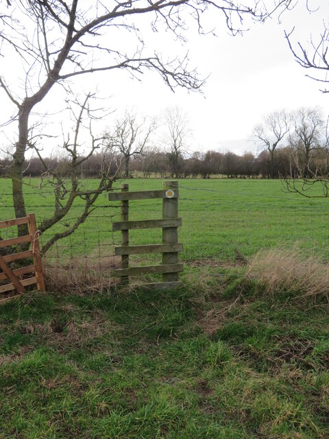
North Cowton church and hall The church itself <a href="https://www.geograph.org.uk/photo/4741036">NZ2804 :  St Luke's Church, North Cowton</a> is now closed, but the hall may well remain in use by the parish.
North Cowton church and hall
The church itself NZ2804 : St Luke's Church, North Cowton is now closed, but the hall may well remain in use by the parish.
Former church of St Luke, North Cowton  Originally constructed as a pastoral centre for the parish of East Cowton in 1968, St Luke’s was consecrated as a parish church on 21 October 1990 following the closure of St Mary's. it was closed on 1 July 2018 due to dwindling numbers and lack of step-free access. Since this photo it has been sold to a private buyer for secular use.
Former church of St Luke, North Cowton
Originally constructed as a pastoral centre for the parish of East Cowton in 1968, St Luke’s was consecrated as a parish church on 21 October 1990 following the closure of St Mary's. it was closed on 1 July 2018 due to dwindling numbers and lack of step-free access. Since this photo it has been sold to a private buyer for secular use.
Former church of St Luke, North Cowton - interior Originally constructed as a pastoral centre for the parish of East Cowton in 1968, St Luke’s was consecrated as a parish church on 21 October 1990 following the closure of St Mary's. The stone arch seen in the east wall came from St Mary's when it was demolished. 

St Luke's was closed on 1 July 2018 and since this photo it has been sold to a private buyer for secular use and there is no public access. See <a href="https://www.geograph.org.uk/photo/7364235">NZ2804 : Former church of St Luke, North Cowton </a> for the outside.
Former church of St Luke, North Cowton - interior
Originally constructed as a pastoral centre for the parish of East Cowton in 1968, St Luke’s was consecrated as a parish church on 21 October 1990 following the closure of St Mary's. The stone arch seen in the east wall came from St Mary's when it was demolished. St Luke's was closed on 1 July 2018 and since this photo it has been sold to a private buyer for secular use and there is no public access. See NZ2804 : Former church of St Luke, North Cowton for the outside.
Former church of St Luke, North Cowton - consecration plaque See <a href="https://www.geograph.org.uk/photo/7364235">NZ2804 : Former church of St Luke, North Cowton </a> for the outside of this church, which was built in 1968.
Former church of St Luke, North Cowton - consecration plaque
See NZ2804 : Former church of St Luke, North Cowton for the outside of this church, which was built in 1968.
Straw bales by a farm track The barn doesn't appear on another photo which I took looking in the opposite direction in January 2009, so obviously of recent construction.
Straw bales by a farm track
The barn doesn't appear on another photo which I took looking in the opposite direction in January 2009, so obviously of recent construction.
Where's the path? Trying to follow the line marked on the map across this field of old ridge and furrow as well as remains of a medieval village site. The path is shown crossing the farm track midway between a corner and the farm buildings, but the track is lined by barbed wire fencing with no visible means of crossing. Way down to the left is a flimsy stile [left of photo] from where there is a usable route along a hedge line.
Where's the path?
Trying to follow the line marked on the map across this field of old ridge and furrow as well as remains of a medieval village site. The path is shown crossing the farm track midway between a corner and the farm buildings, but the track is lined by barbed wire fencing with no visible means of crossing. Way down to the left is a flimsy stile [left of photo] from where there is a usable route along a hedge line.
A stile on a terrible path 'Stile' is hardly an appropriate description for this fence crossing as there are no footboards and the upright posts have barbed wire attached. However this is probably the easiest crossing on a dreadful footpath that involves rotted timber stiles, fighting with vegetation, avoiding electric fencing, and crossing two water filled ditches, one of which has a footbridge, according to the NYCC official map, but which in fact doesn't exist. Other walkers should avoid path 20.52/4 and walk along the roadside instead.
A stile on a terrible path
'Stile' is hardly an appropriate description for this fence crossing as there are no footboards and the upright posts have barbed wire attached. However this is probably the easiest crossing on a dreadful footpath that involves rotted timber stiles, fighting with vegetation, avoiding electric fencing, and crossing two water filled ditches, one of which has a footbridge, according to the NYCC official map, but which in fact doesn't exist. Other walkers should avoid path 20.52/4 and walk along the roadside instead.
Houses on Holywell Lane A road leading out of the village with what look like ex local authority houses on the left.
Houses on Holywell Lane
A road leading out of the village with what look like ex local authority houses on the left.
Village hall, North Cowton Other contributors have placed the hall in the adjacent square, but the map would suggest that it is just inside this grid square. There have also been changes in recent years as the small church that stood to the left of the hall has gone, and a new house has been erected in its place on what is a very restricted site.
Village hall, North Cowton
Other contributors have placed the hall in the adjacent square, but the map would suggest that it is just inside this grid square. There have also been changes in recent years as the small church that stood to the left of the hall has gone, and a new house has been erected in its place on what is a very restricted site.
St Mary's churchyard, East Cowton - headstones St Mary's was a medieval church, half a mile west of the village, which fell into ruin after being replaced by the present All Saints in the village in 1910. The ruins were demolished c.1968. The churchyard remains open for burials as can be seen by the recent headstone in the foreground to Ursula and James Kinsella.
St Mary's churchyard, East Cowton - headstones
St Mary's was a medieval church, half a mile west of the village, which fell into ruin after being replaced by the present All Saints in the village in 1910. The ruins were demolished c.1968. The churchyard remains open for burials as can be seen by the recent headstone in the foreground to Ursula and James Kinsella.
St Mary's churchyard, East Cowton - chest tomb St Mary's was a medieval church, half a mile west of the village, which fell into ruin after being replaced by the present All Saints in the village in 1910. The ruins were just beyond the end of the path in this view but were demolished c.1968.
St Mary's churchyard, East Cowton - chest tomb
St Mary's was a medieval church, half a mile west of the village, which fell into ruin after being replaced by the present All Saints in the village in 1910. The ruins were just beyond the end of the path in this view but were demolished c.1968.
St Mary's churchyard, East Cowton - trees A pair of Irish yew trees.
St Mary's churchyard, East Cowton - trees
A pair of Irish yew trees.
All Saints, East Cowton - north side The church was built in 1909, architects Woolfall & Eccles of Liverpool, and is grade II listed (list entry 1376534).
All Saints, East Cowton - north side
The church was built in 1909, architects Woolfall & Eccles of Liverpool, and is grade II listed (list entry 1376534).
All Saints, East Cowton - south side The church was built in 1909, architects Woolfall & Eccles of Liverpool, and is grade II listed (list entry 1376534). The southern extension is more recent.
All Saints, East Cowton - south side
The church was built in 1909, architects Woolfall & Eccles of Liverpool, and is grade II listed (list entry 1376534). The southern extension is more recent.
All Saints, East Cowton - east end The church was built in 1909, architects Woolfall & Eccles of Liverpool, and is grade II listed (list entry 1376534). The east window looks to have been designed for a single stained glass scene, but has been partly infilled with stone with a few smaller glazed panels.
All Saints, East Cowton - east end
The church was built in 1909, architects Woolfall & Eccles of Liverpool, and is grade II listed (list entry 1376534). The east window looks to have been designed for a single stained glass scene, but has been partly infilled with stone with a few smaller glazed panels.
All Saints, East Cowton - interior with organ An unusual arrangement with the organ forming a barrier between the nave and chancel. This suggests it is a later addition but the National Pipe Organ Register says the organ came from St Mary, Staindrop in 1909 (i.e. when All Saints was built) and was restored in 1991. See <a href="https://www.geograph.org.uk/photo/7364250">NZ3003 : All Saints, East Cowton - north side</a> for the outside.
All Saints, East Cowton - interior with organ
An unusual arrangement with the organ forming a barrier between the nave and chancel. This suggests it is a later addition but the National Pipe Organ Register says the organ came from St Mary, Staindrop in 1909 (i.e. when All Saints was built) and was restored in 1991. See NZ3003 : All Saints, East Cowton - north side for the outside.
All Saints, East Cowton - war memorial Erected in 1921 and grade II listed (list entry 1452758).
All Saints, East Cowton - war memorial
Erected in 1921 and grade II listed (list entry 1452758).
Village street East Cowton Towards the eastern end of the village. The turning for Birkby is by the white house in the distance.
Village street East Cowton
Towards the eastern end of the village. The turning for Birkby is by the white house in the distance.
Show me another place!

Black Wood is located at Grid Ref: NZ2903 (Lat: 54.424313, Lng: -1.5427732)

Division: North Riding

Administrative County: North Yorkshire

District: Hambleton

Police Authority: North Yorkshire

What 3 Words

///tester.sailed.overtones. Near Scorton, North Yorkshire

Nearby Locations

Black Wood

Related Wikis

Temple Cowton Preceptory

Temple Cowton Preceptory was a priory in North Yorkshire, England. The preceptory was in the village of East Cowton, 5 miles (8 km) north west of Northallerton...

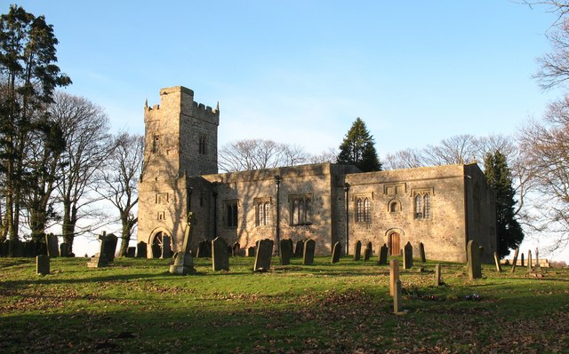
St Mary's Church, South Cowton

St Mary's Church is a redundant Anglican church standing in open countryside in the former village of South Cowton, near Scotch Corner in North Yorkshire...
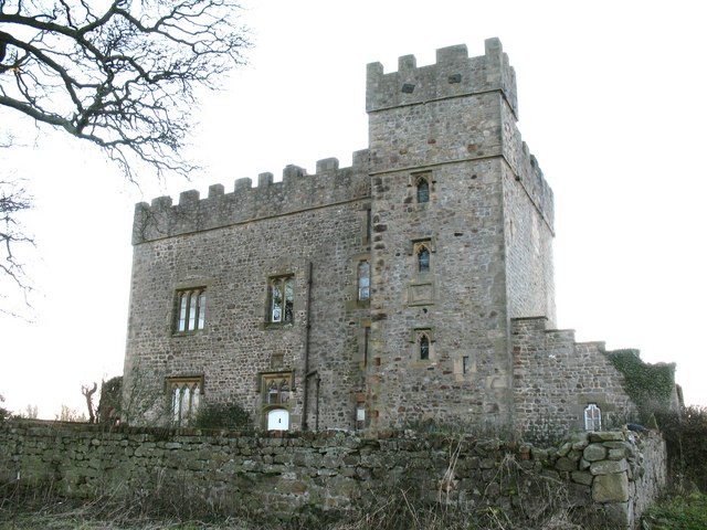
South Cowton Castle

South Cowton Castle is a 15th-century fortified dwelling house in the Richmondshire district of North Yorkshire, England. It is situated on the land that...

East Cowton

East Cowton is a village and civil parish in the Hambleton District of North Yorkshire, England. It is 7 miles (11 km) north west of the county town of...

South Cowton

South Cowton is a village and civil parish located on the site of an abandoned medieval village in the Hambleton district of North Yorkshire in England...

North Cowton

North Cowton is a village and civil parish, located in Richmondshire, North Yorkshire, England. It is 8 miles (13 km) north-west of the county town of...

Atley Hill

Atley Hill is a hamlet in the Hambleton district of North Yorkshire, England. It is situated on the B1263 road between the A167 and the village of Scorton...

Dalton Gates

Dalton Gates is a hamlet in the Richmondshire district of North Yorkshire, England. The hamlet was built up around the now disused railway station that...

Have you been to Black Wood?

Leave your review of Black Wood below (or comments, questions and feedback).