Crag Wood

Wood, Forest in Yorkshire Harrogate

England

Crag Wood

Water Lane Bridleway 15 121/4/1 follows this traffic-free lane west of the A61. The notice on the left warns thieves to beware. Viewed from just west of <a title="https://www.geograph.org.uk/search.php?i=31006289" href="https://www.geograph.org.uk/search.php?i=31006289">Link</a> .
Water Lane Credit: Derek Harper

Crag Wood, located in Yorkshire, is a stunning forest that captivates visitors with its natural beauty and rich history. Spanning over a vast area, this woodland is renowned for its diverse flora and fauna, making it an ideal destination for nature enthusiasts.

The wood is characterized by its dense canopy of towering trees, including oak, beech, and birch, which provide a habitat for various bird species such as woodpeckers, owls, and thrushes. The forest floor is adorned with a colorful carpet of wildflowers, ferns, and mosses, creating a picturesque setting that changes with the seasons.

Within Crag Wood, there are numerous walking trails that wind through its enchanting landscape. These paths offer visitors the opportunity to explore and discover hidden treasures, including ancient stone formations and remnants of prehistoric settlements. The wood also boasts a tranquil stream that meanders through its heart, adding to the serenity of the surroundings.

For those interested in history, Crag Wood holds particular significance. It is believed to have been inhabited by humans for thousands of years, and evidence of ancient settlements and burial sites can still be found within its boundaries. Archaeologists have unearthed artifacts and tools that shed light on the lives of our ancestors, making Crag Wood a site of both natural and historical importance.

Overall, Crag Wood in Yorkshire is a truly remarkable destination, offering a harmonious blend of natural beauty and cultural heritage. Whether one seeks the peace and tranquility of a woodland retreat or desires to delve into the secrets of the past, Crag Wood is a place that never fails to captivate and inspire.

If you have any feedback on the listing, please let us know in the comments section below.
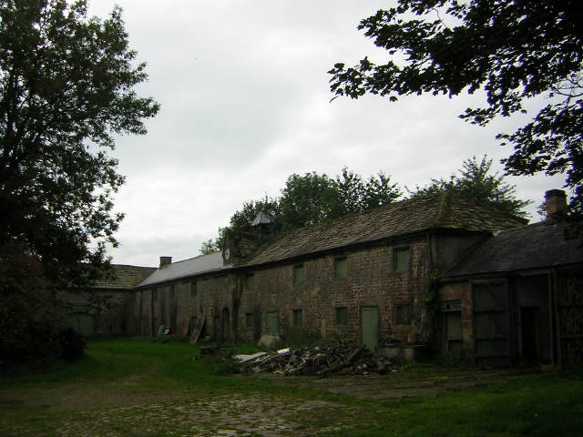
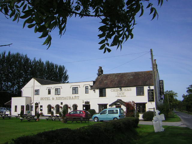
Crag Wood Images

Images are sourced within 2km of 54.064686/-1.5705197 or Grid Reference SE2863. Thanks to Geograph Open Source API. All images are credited.

Water Lane Bridleway 15 121/4/1 follows this traffic-free lane west of the A61. The notice on the left warns thieves to beware. Viewed from just west of <a title="https://www.geograph.org.uk/search.php?i=31006289" href="https://www.geograph.org.uk/search.php?i=31006289">Link</a> .
Water Lane
Bridleway 15 121/4/1 follows this traffic-free lane west of the A61. The notice on the left warns thieves to beware. Viewed from just west of Link .
Field boundary by Water Lane Looking past the edge of Shrog Wood (left) from the lane shown in <a href="https://www.geograph.org.uk/photo/2927016">SE3063 : Water Lane</a>, with a rather intermittent hedge.
Field boundary by Water Lane
Looking past the edge of Shrog Wood (left) from the lane shown in SE3063 : Water Lane, with a rather intermittent hedge.
Ploughed Field by Water Lane Country to the west of South Stainley
Ploughed Field by Water Lane
Country to the west of South Stainley
Hectaire Cottage known as Hectaire/Looking north east from Law Lane, between Bedlam and Shaw Mills
Hectaire
Cottage known as Hectaire/Looking north east from Law Lane, between Bedlam and Shaw Mills
Markington Small Village between Ripon and Harrogate
Markington
Small Village between Ripon and Harrogate
Road west out of Markington The road heading to the village of Bishop Thornton, from Markington
Road west out of Markington
The road heading to the village of Bishop Thornton, from Markington
Scarah Mill from Thornton Beck Bridge No longer a working mill sadly, now a private house with extensive orchards, on the bridge in the foreground is the parish boundary markings of Clint to the left and Ripley to the right
Scarah Mill from Thornton Beck Bridge
No longer a working mill sadly, now a private house with extensive orchards, on the bridge in the foreground is the parish boundary markings of Clint to the left and Ripley to the right
Markington Church Church of Saint Michael the Archangel in the Parishes of Markington, South Stainley and Bishop Thornton
Markington Church
Church of Saint Michael the Archangel in the Parishes of Markington, South Stainley and Bishop Thornton
Bishop Thornton The Chequers Inn, once a quiet country pub, now a hotel, restaurant and caravan site.
Bishop Thornton
The Chequers Inn, once a quiet country pub, now a hotel, restaurant and caravan site.
Slate Rigg farm Like many working farms now supplementing the income by offering B & B and the chance to see real farming in action
Slate Rigg farm
Like many working farms now supplementing the income by offering B & B and the chance to see real farming in action
High Cayton Farm Taken from the junction of bridleways SW of the farm. Gateways lead through the farmyard to the site of the old Medieval village of Cayton.
High Cayton Farm
Taken from the junction of bridleways SW of the farm. Gateways lead through the farmyard to the site of the old Medieval village of Cayton.
Cayton Hall Stables Sad reflection of how a once fine stable yard has degenerated into disrepair
Cayton Hall Stables
Sad reflection of how a once fine stable yard has degenerated into disrepair
Chimney Barn Barn converted about 4 years ago into family home, the original stones were used and private courtyard at the rear is maintained to original designs
Chimney Barn
Barn converted about 4 years ago into family home, the original stones were used and private courtyard at the rear is maintained to original designs
Eden Bank Part of Cayton Gill Farm, lots of horse pastures and little else
Eden Bank
Part of Cayton Gill Farm, lots of horse pastures and little else
Cayton Grange A small hamlet of three or so houses, reached by BW or permissive footpath from Ripley. All part of the Ripley Castle Estates
Cayton Grange
A small hamlet of three or so houses, reached by BW or permissive footpath from Ripley. All part of the Ripley Castle Estates
Bridleway to Cayton Grange Unnamed woods used as a breeding area for game birds, the BW follows field boundaries between the noisy and busy A61 and quiet secluded Cayton Grange
Bridleway to Cayton Grange
Unnamed woods used as a breeding area for game birds, the BW follows field boundaries between the noisy and busy A61 and quiet secluded Cayton Grange
Nidderdale Way at Scarah Bank Eastern end of the Nidderdale Way as it enters Ten Acre Plantation on the way to Cayton Gill
Nidderdale Way at Scarah Bank
Eastern end of the Nidderdale Way as it enters Ten Acre Plantation on the way to Cayton Gill
Oakwood House Part of the complex of Cryer Furniture, this building and Roundwood Stonemasons next door are fairly recent additions to what was a poultry farm.
Oakwood House
Part of the complex of Cryer Furniture, this building and Roundwood Stonemasons next door are fairly recent additions to what was a poultry farm.
Show me another place!

Crag Wood is located at Grid Ref: SE2863 (Lat: 54.064686, Lng: -1.5705197)

Division: West Riding

Administrative County: North Yorkshire

District: Harrogate

Police Authority: North Yorkshire

What 3 Words

///bulldozer.pads.befitting. Near Ripon, North Yorkshire

Related Wikis

Markington

Markington is a village in the Harrogate district, in the English county of North Yorkshire. The population of the civil parish (including Markenfield...

Bedlam, North Yorkshire

Bedlam is a small village in the Harrogate district of North Yorkshire, England situated north of Harrogate.Its name most likely came from Old English...

Bishop Thornton

Bishop Thornton is a village in the civil parish of Bishop Thornton, Shaw Mills and Warsill, in the Harrogate district of North Yorkshire, England. According...

Ripley, North Yorkshire

Ripley is a town and civil parish in North Yorkshire in England, a few miles north of Harrogate on the A61 road towards Ripon. The town name derives from...

Ripley Castle

Ripley Castle is a Grade I listed 14th-century country house in Ripley, North Yorkshire, England, 3 miles (4.8 km) north of Harrogate.The house is built...

Wormald Green railway station

Wormald Green railway station served the village of Wormald Green, Harrogate, England from 1848 to 1964 on the Leeds-Northallerton Railway. == History... ==

Ripley Town Hall, North Yorkshire

Ripley Town Hall is a municipal building in Main Street, Ripley, North Yorkshire, England. The structure, which is used as an events venue and as a post...

South Stainley

South Stainley is a small village in the Harrogate District, in the county of North Yorkshire, England. Nearby settlements include the city of Ripon, the...

Nearby Amenities

Located within 500m of 54.064686,-1.5705197
Ford: yes
Lat/Long: 54.0632474/-1.5702245
Power: pole
Lat/Long: 54.0620358/-1.5765059
Power: pole
Lat/Long: 54.0624734/-1.5752506
Power: pole
Lat/Long: 54.0634935/-1.5724853
Power: pole
Lat/Long: 54.0646111/-1.5694302
Power: pole
Lat/Long: 54.0649023/-1.5681615
Power: pole
Lat/Long: 54.0651998/-1.5667909
Power: pole
Lat/Long: 54.0654958/-1.5654337
Power: pole
Lat/Long: 54.0657917/-1.5640819
The data included in this document is from www.openstreetmap.org. The data is made available under ODbL.

Have you been to Crag Wood?

Leave your review of Crag Wood below (or comments, questions and feedback).