Pig Wood

Wood, Forest in Warwickshire

England

Pig Wood

Farmland near Allesley Green Looking South from the footpath by the golf course. This crop was planted in the Autumn. I believe it is wheat - we shall see.
Farmland near Allesley Green Credit: John Winterbottom

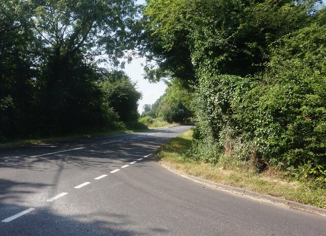
Pig Wood is a picturesque forest located in Warwickshire, England. Covering an area of approximately 100 acres, it is a popular destination for nature enthusiasts and outdoor adventurers. The wood is characterized by its dense canopy of ancient oak trees, which provide shelter and habitat for a diverse range of wildlife.

The forest floor of Pig Wood is carpeted with a thick layer of leaf litter, creating a rich and fertile soil. This environment supports a wide variety of plant species, including bluebells, wood anemones, and wild garlic, which create a beautiful display of colors during the spring months. The wood is also home to several species of fungi, such as the fly agaric and the wood ear fungus.

Birdwatchers will delight in the numerous avian species that call Pig Wood their home. Visitors may spot woodpeckers, thrushes, and owls, among others. The wood is also frequented by small mammals, including badgers, foxes, and squirrels, which can often be observed scurrying through the undergrowth.

Pig Wood offers several walking trails, allowing visitors to explore its natural beauty at their own pace. These trails wind through the forest, offering glimpses of scenic vistas and tranquil glades. The wood is also a popular spot for picnics and nature photography.

With its peaceful ambiance and abundance of flora and fauna, Pig Wood is a true gem in the heart of Warwickshire. Whether one seeks a leisurely stroll through nature or a chance to immerse themselves in the wilderness, this idyllic forest offers an unforgettable experience for all who visit.

If you have any feedback on the listing, please let us know in the comments section below.

Pig Wood Images

Images are sourced within 2km of 52.402774/-1.5874744 or Grid Reference SP2878. Thanks to Geograph Open Source API. All images are credited.

Farmland near Allesley Green Looking South from the footpath by the golf course. This crop was planted in the Autumn. I believe it is wheat - we shall see.
Farmland near Allesley Green
Looking South from the footpath by the golf course. This crop was planted in the Autumn. I believe it is wheat - we shall see.
Farmland west of Allesley Green Arable land, new crop just showing. The building on the skyline (centre) is the top of the ex-Massey Ferguson tower block.
Farmland west of Allesley Green
Arable land, new crop just showing. The building on the skyline (centre) is the top of the ex-Massey Ferguson tower block.
Allesley Green from Park Hill Lane A 1980s housing estate.  Just visible on the skyline is the woodland north of Meriden.
Allesley Green from Park Hill Lane
A 1980s housing estate. Just visible on the skyline is the woodland north of Meriden.
Sutton Avenue, Upper Eastern Green
The Poachers Retreat public house
Houses at the junction of Beaumaris Close and Parkhill Drive I believe this part of the estate was built in the 1980's by Bryant Homes.
Houses at the junction of Beaumaris Close and Parkhill Drive
I believe this part of the estate was built in the 1980's by Bryant Homes.
Poachers Retreat Hockley Lane The pub has been closed and in January 2011 the council discussed an application from James O'Flanagan Ltd to build six houses on this site. They did not have any objection.
Poachers Retreat Hockley Lane
The pub has been closed and in January 2011 the council discussed an application from James O'Flanagan Ltd to build six houses on this site. They did not have any objection.
Poachers Retreat Hockley Lane This pub closed early in 2011 or late 2010. see  <a href="https://www.geograph.org.uk/photo/2581093">SP2780 : Poachers Retreat Hockley Lane</a>
Poachers Retreat Hockley Lane
This pub closed early in 2011 or late 2010. see SP2780 : Poachers Retreat Hockley Lane
Upper Eastern Green Lane These semi detached houses are right on the fringes of Coventry and their gardens back onto open countryside.
Upper Eastern Green Lane
These semi detached houses are right on the fringes of Coventry and their gardens back onto open countryside.
Morgans Road, Upper Eastern Green
Broad Lane, Upper Eastern Green
Tanner's Lane from Benton Green Lane
Greek Orthodox Church, Westwood Heath Road, Coventry The flags of Cyprus, the United Kingdom and Greece can be seen flying outside the Greek Orthodox Church of the Holy Transfiguration. The church was open to the public on a Heritage Open Day. Tours of the church building were taking place and, in St. George's Hall, the red brick building visible to the right behind the church, could be seen a display on the history of the church and the Greek Cypriot community and another on the history of the Westwood Heath area by the Westwood Heath History Group. For the website of the church see here <span class="nowrap"><a title="https://greekchurchcoventry.org/index.html" rel="nofollow ugc noopener" href="https://greekchurchcoventry.org/index.html">Link</a><img style="margin-left:2px;" alt="External link" title="External link - shift click to open in new window" src="https://s1.geograph.org.uk/img/external.png" width="10" height="10"/></span> , for the website of the history group see here <span class="nowrap"><a title="https://westwoodheathra.wixsite.com/website" rel="nofollow ugc noopener" href="https://westwoodheathra.wixsite.com/website">Link</a><img style="margin-left:2px;" alt="External link" title="External link - shift click to open in new window" src="https://s1.geograph.org.uk/img/external.png" width="10" height="10"/></span> .

According to the church display, the first Cypriot migrants arrived in Coventry in the 1930s. At that time Cyprus was a colony of the British Empire. Increasing migration in the 1950s and 1960s led to the establishment of a Greek-language supplementary school and a Greek Orthodox church, which worshipped in Church of England churches. In 1977 the community acquired a Victorian school building in Westwood Heath. This was consecrated as an Orthodox church in 1978. It has since been extended, while classrooms for the Greek school have been built along with St George's Hall as a community venue <span class="nowrap"><a title="https://greekchurchcoventry.org/about-us.html" rel="nofollow ugc noopener" href="https://greekchurchcoventry.org/about-us.html">Link</a><img style="margin-left:2px;" alt="External link" title="External link - shift click to open in new window" src="https://s1.geograph.org.uk/img/external.png" width="10" height="10"/></span> . The site overlooks the Warwickshire countryside beyond the city.

The church itself has the rectangular shape and rows of wooden pews of a western church building, but there is no mistaking the Orthodox character of the painted icons on the walls and on the iconostasis, the screen which divides the sanctuary with the altar from the main body of the church.
Greek Orthodox Church, Westwood Heath Road, Coventry
The flags of Cyprus, the United Kingdom and Greece can be seen flying outside the Greek Orthodox Church of the Holy Transfiguration. The church was open to the public on a Heritage Open Day. Tours of the church building were taking place and, in St. George's Hall, the red brick building visible to the right behind the church, could be seen a display on the history of the church and the Greek Cypriot community and another on the history of the Westwood Heath area by the Westwood Heath History Group. For the website of the church see here LinkExternal link , for the website of the history group see here LinkExternal link . According to the church display, the first Cypriot migrants arrived in Coventry in the 1930s. At that time Cyprus was a colony of the British Empire. Increasing migration in the 1950s and 1960s led to the establishment of a Greek-language supplementary school and a Greek Orthodox church, which worshipped in Church of England churches. In 1977 the community acquired a Victorian school building in Westwood Heath. This was consecrated as an Orthodox church in 1978. It has since been extended, while classrooms for the Greek school have been built along with St George's Hall as a community venue LinkExternal link . The site overlooks the Warwickshire countryside beyond the city. The church itself has the rectangular shape and rows of wooden pews of a western church building, but there is no mistaking the Orthodox character of the painted icons on the walls and on the iconostasis, the screen which divides the sanctuary with the altar from the main body of the church.
Leafy suburbia, Job’s Lane
Housing in Job’s Lane
Limbrick Wood Centre Entrance to Limbrick Wood School.
Limbrick Wood Centre
Entrance to Limbrick Wood School.
Housing blocks in Ferrers Close
Broad Lane Broad Lane on the outskirts of Coventry Lane on the outskirts of Coventry
Broad Lane
Broad Lane on the outskirts of Coventry Lane on the outskirts of Coventry
Show me another place!

Pig Wood is located at Grid Ref: SP2878 (Lat: 52.402774, Lng: -1.5874744)

Unitary Authority: Coventry

Police Authority: West Midlands

What 3 Words

///shark.calm.people. Near Berkswell, West Midlands

Related Wikis

West Coventry Academy

West Coventry Academy is a co-educational secondary school and sixth form located in the Tile Hill area of Coventry, West Midlands, England. It was formed...

Tile Hill Wood

Tile Hill Wood is a wood between Hawthorn Lane and Banner Lane in the Tile Hill area of Coventry, England. It has been designated as a Site of Special...

Tile Hill

Tile Hill is a suburb in the west of Coventry, West Midlands, England. It is mostly residential and partly industrial, with some common land and wooded...
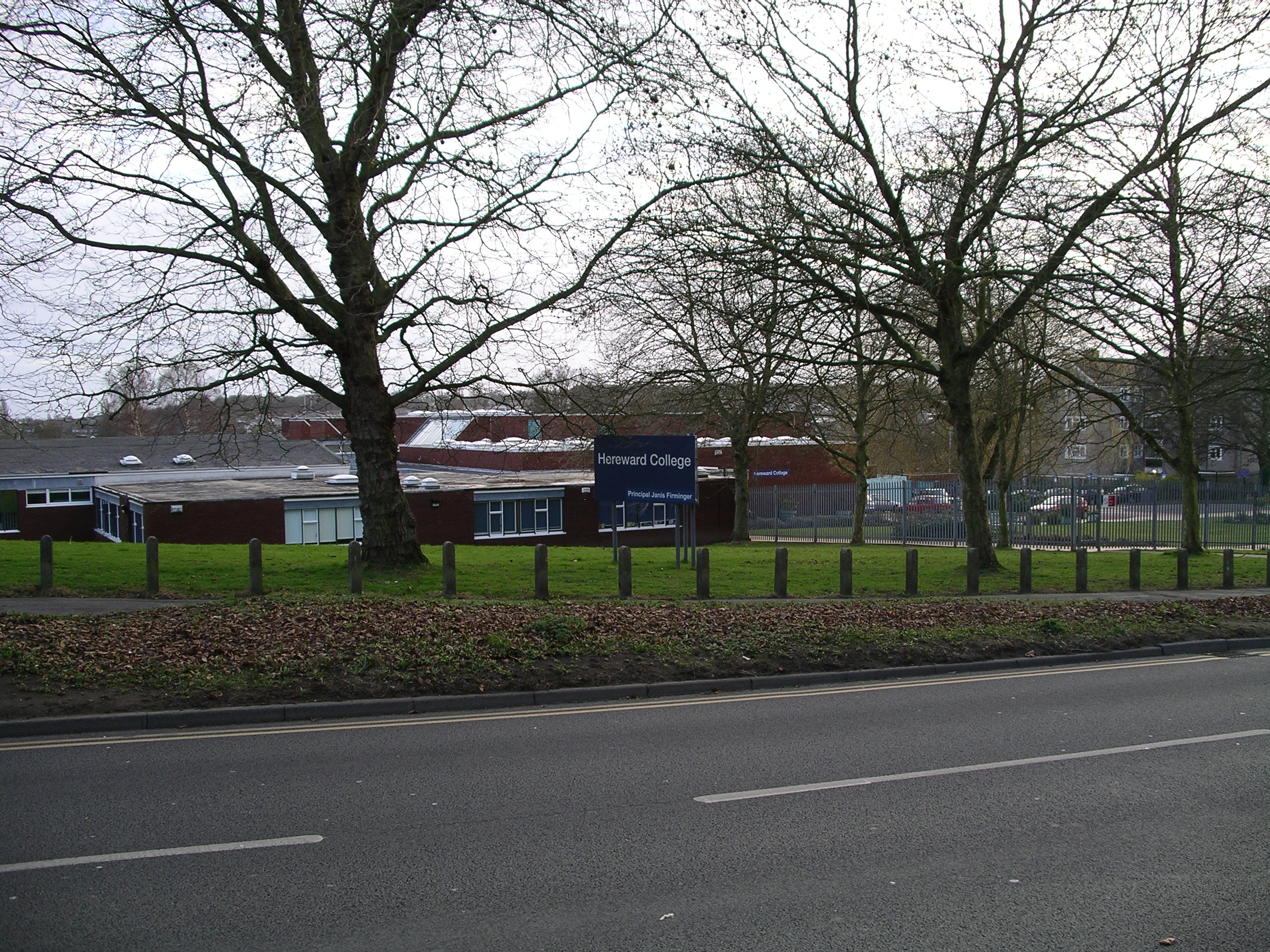
Hereward College

Hereward College is a national further education college specialising in skills for independent living and employment for young people with disabilities...

Massey Ferguson F.C.

Massey Ferguson Sports & Social F.C. are a football club based in Coventry, England. They joined the Midland Combination Division Two in 1993. They currently...

Tile Hill railway station

Tile Hill railway station is situated in the west of Tile Hill, Coventry, in the West Midlands of England. The station, and all trains serving it, are...

Woodlands Academy, Coventry

Woodlands Academy (formerly The Woodlands School and Sports College) was a boys secondary school situated in west Coventry in the West Midlands, England...

Finham Park 2

Finham Park 2 is a secondary school and sixth form located on Torrington Avenue in Tile Hill, Coventry. It was founded on 1 September 2015 as a sequel...

Nearby Amenities

Located within 500m of 52.402774,-1.5874744
Crossing
Crossing: unmarked
Crossing Island: no
Crossing Markings: no
Kerb: lowered
Tactile Paving: yes
Lat/Long: 52.4014797/-1.5814073
Turning Circle
Lat/Long: 52.3991605/-1.5865532
Turning Circle
Lat/Long: 52.3992153/-1.5876546
Turning Circle
Lat/Long: 52.399214/-1.5887216
Tile Hill
Created By: Potlatch 0.10f
Is In: Coventry
Place: suburb
Lat/Long: 52.402557/-1.5835657
Bus Stop
Tile Hill Lane / Bushbery Avenue
NaPTANAreaCode: 43000074001
Bench: yes
Bin: no
Bus: yes
Lit: yes
Naptan AtcoCode: 43000074001
Naptan Bearing: W
Naptan BusStopType: MKD
Naptan CommonName: Bushbery Avenue
Naptan Indicator: opp
Naptan NaptanCode: nwmgagat
Naptan PlusbusZoneRef: BHAMNWS
Naptan Status: ACT
Naptan StopType: BCT
Naptan Street: TILE HILL LANE
Naptan Towards: Tanyard Farm
Naptan Verified: no
Public Transport: platform
Route Ref: 6
Shelter: yes
Shelter Ref: 713028
Source: WMCA
Tactile Paving: no
Lat/Long: 52.4019394/-1.5829835
Bus Stop
Tile Hill Lane / Bushbery Avenue
Bench: no
Bin: no
Bus: yes
Lit: yes
Naptan AtcoCode: 43000074002
Naptan Bearing: E
Naptan BusStopType: MKD
Naptan CommonName: Bushbery Avenue
Naptan Indicator: adj
Naptan NaptanCode: nwmgagaw
Naptan PlusbusZoneRef: BHAMNWS
Naptan Status: ACT
Naptan StopType: BCT
Naptan Street: TILE HILL LANE
Naptan Towards: Tile Hill
Naptan Verified: no
Public Transport: platform
Shelter: yes
Source: WMCA
Tactile Paving: yes
Lat/Long: 52.4021432/-1.5812145
Bus Stop
Bushbery Avenue / Pinnock Place
NaPTANAreaCode: 43000074101
Bench: yes
Bin: yes
Bus: yes
Lit: yes
Naptan AtcoCode: 43000074101
Naptan Bearing: N
Naptan BusStopType: MKD
Naptan CommonName: Pinnock Place
Naptan Indicator: opp
Naptan NaptanCode: nwmgagda
Naptan PlusbusZoneRef: BHAMNWS
Naptan Status: ACT
Naptan StopType: BCT
Naptan Street: BUSHBERY AVENUE
Naptan Towards: City Centre
Naptan Verified: no
Public Transport: platform
Route Ref: 6
Shelter: yes
Shelter Ref: 711434
Source: WMCA
Tactile Paving: yes
Lat/Long: 52.4024426/-1.5818448
Bus Stop
Bushbery Avenue / Pinnock Place
NaPTANAreaCode: 43000074102
Bench: yes
Bin: yes
Bus: yes
Lit: yes
Naptan AtcoCode: 43000074102
Naptan Bearing: S
Naptan BusStopType: MKD
Naptan CommonName: Pinnock Place
Naptan Indicator: adj
Naptan NaptanCode: nwmgagdg
Naptan PlusbusZoneRef: BHAMNWS
Naptan Status: ACT
Naptan StopType: BCT
Naptan Street: BUSHBERY AVENUE
Naptan Towards: Tanyard Farm
Naptan Verified: no
Public Transport: platform
Route Ref: 6
Shelter: yes
Shelter Ref: 711420
Source: WMCA
Tactile Paving: yes
Lat/Long: 52.4031324/-1.5817657
Bus Stop
Bushbery Avenue / Frisby Rd
NaPTANAreaCode: 43000074201
Bench: yes
Bin: yes
Bus: yes
Lit: yes
Naptan AtcoCode: 43000074201
Naptan Bearing: S
Naptan BusStopType: MKD
Naptan CommonName: Frisby Rd
Naptan Indicator: opp
Naptan NaptanCode: nwmgagdm
Naptan PlusbusZoneRef: BHAMNWS
Naptan Status: ACT
Naptan StopType: BCT
Naptan Street: BUSHBERY AVENUE
Naptan Towards: Tanyard Farm
Naptan Verified: no
Public Transport: platform
Route Ref: 6
Shelter: yes
Shelter Ref: 711421
Source: WMCA
Tactile Paving: yes
Lat/Long: 52.4045937/-1.5817429
Bus Stop
Bushbery Avenue / Frisby Rd
NaPTANAreaCode: 43000074202
Bench: yes
Bin: yes
Bus: yes
Lit: yes
Naptan AtcoCode: 43000074202
Naptan Bearing: N
Naptan BusStopType: MKD
Naptan CommonName: Frisby Rd
Naptan Indicator: adj
Naptan NaptanCode: nwmgagdp
Naptan PlusbusZoneRef: BHAMNWS
Naptan Status: ACT
Naptan StopType: BCT
Naptan Street: BUSHBERY AVENUE
Naptan Towards: City Centre
Naptan Verified: no
Public Transport: platform
Route Ref: 6
Shelter: yes
Shelter Ref: 711438
Source: WMCA
Tactile Paving: yes
Lat/Long: 52.4048265/-1.5818542
Bus Stop
Tile Hill Lane / Hawthorn Lane
NaPTANAreaCode: 43000074601
Bus: yes
Naptan AtcoCode: 43000074601
Naptan Bearing: W
Naptan BusStopType: MKD
Naptan CommonName: Hawthorn Lane
Naptan Indicator: opp
Naptan NaptanCode: nwmgagjg
Naptan PlusbusZoneRef: BHAMNWS
Naptan Status: ACT
Naptan StopType: BCT
Naptan Street: TILE HILL LANE
Naptan Towards: Tanyard Farm
Naptan Verified: no
Public Transport: platform
Route Ref: 6;43;43A;43W
Shelter: yes
Shelter Ref: 713029
Source: WMCA
Lat/Long: 52.4017111/-1.5865213
Bus Stop
Tile Hill Lane / Hawthorn Lane
NaPTANAreaCode: 43000074602
Bench: yes
Bin: yes
Bus: yes
Lit: yes
Naptan AtcoCode: 43000074602
Naptan Bearing: E
Naptan BusStopType: MKD
Naptan CommonName: Hawthorn Lane
Naptan Indicator: adj
Naptan NaptanCode: nwmgagjm
Naptan PlusbusZoneRef: BHAMNWS
Naptan Status: ACT
Naptan StopType: BCT
Naptan Street: TILE HILL LANE
Naptan Towards: City Centre
Naptan Verified: no
Public Transport: platform
Route Ref: 6;43;43A;43W
Shelter: yes
Shelter Ref: 713022
Source: WMCA
Tactile Paving: yes
Lat/Long: 52.4019751/-1.584116
Bus Stop
Tile Hill Lane / Tile Hill Wood School
NaPTANAreaCode: 43000074701
Bench: no
Bin: no
Bus: yes
Naptan AtcoCode: 43000074701
Naptan Bearing: W
Naptan BusStopType: MKD
Naptan CommonName: Tile Hill Wood School
Naptan Indicator: opp
Naptan NaptanCode: nwmgagjp
Naptan PlusbusZoneRef: BHAMNWS
Naptan Status: ACT
Naptan StopType: BCT
Naptan Street: TILE HILL LANE
Naptan Towards: Tanyard Farm
Naptan Verified: no
Public Transport: platform
Route Ref: 6;43;43A;43W
Shelter: yes
Shelter Ref: 713030
Source: WMCA
Lat/Long: 52.4014121/-1.5893888
Bus Stop
Tile Hill Lane / Tile Hill Wood School
NaPTANAreaCode: 43000074702
Bus: yes
Naptan AtcoCode: 43000074702
Naptan Bearing: E
Naptan BusStopType: MKD
Naptan CommonName: Tile Hill Wood School
Naptan Indicator: adj
Naptan NaptanCode: nwmgagjt
Naptan PlusbusZoneRef: BHAMNWS
Naptan Status: ACT
Naptan StopType: BCT
Naptan Street: TILE HILL LANE
Naptan Towards: City Centre
Naptan Verified: no
Public Transport: platform
Route Ref: 6;43;43A;43W
Shelter: yes
Shelter Ref: 713017
Source: WMCA
Lat/Long: 52.4015955/-1.5889114
Nutbrook Ave / Tile Hill School
Naptan AtcoCode: 43000076901
Naptan Bearing: N
Naptan BusStopType: CUS
Naptan CommonName: Tile Hill School
Naptan Indicator: o/s
Naptan NaptanCode: nwmgajdp
Naptan PlusbusZoneRef: BHAMNWS
Naptan Status: ACT
Naptan StopType: BCT
Naptan Street: NUTBROOK AVE
Naptan Verified: no
Source: WMCA
Lat/Long: 52.404257/-1.589213
Crossing
Crossing: unmarked
Crossing Island: no
Crossing Markings: no
Kerb: lowered
Tactile Paving: no
Lat/Long: 52.4053592/-1.5855574
Crossing
Crossing: uncontrolled
Crossing Island: no
Kerb: lowered
Tactile Paving: yes
Lat/Long: 52.3984336/-1.5855771
Post Box
Check Date Collection Times: 2022-02-19
Collection Times: Mo-Fr 09:00; Sa 07:00
Operator: Royal Mail
Operator Wikidata: Q638098
Post Box Type: lamp
Ref: CV4 347D
Royal Cypher: EIIR
Royal Cypher Wikidata: Q33102113
Source: survey
Lat/Long: 52.4006958/-1.5849919
Crossing
Crossing: uncontrolled
Kerb: lowered
Tactile Paving: yes
Lat/Long: 52.3985258/-1.5896654
Bus Stop
Torrington Ave / Plants Hill Crescent
Bench: no
Bin: no
Bus: yes
Lit: yes
Naptan AtcoCode: 43001771002
Naptan Bearing: W
Naptan BusStopType: MKD
Naptan CommonName: Plants Hill Crescent
Naptan Indicator: opposite
Naptan NaptanCode: nwmapdad
Naptan Status: ACT
Naptan StopType: BCT
Naptan Street: TORRINGTON AVE
Naptan Towards: City Centre
Public Transport: platform
Route Ref: 5
Shelter: no
Source: WMCA
Tactile Paving: no
Lat/Long: 52.3984573/-1.5890431
Bus Stop
Torrington Ave / Plants Hill Crescent
Bench: no
Bin: no
Bus: yes
Lit: yes
Naptan AtcoCode: 43001771001
Naptan Bearing: E
Naptan BusStopType: MKD
Naptan CommonName: Plants Hill Crescent
Naptan Indicator: adjacent
Naptan NaptanCode: nwmapawm
Naptan Status: ACT
Naptan StopType: BCT
Naptan Street: TORRINGTON AVE
Naptan Towards: Tile Hill
Public Transport: platform
Route Ref: 5
Shelter: no
Source: WMCA
Tactile Paving: no
Lat/Long: 52.398583/-1.5890125
Bus Stop
Gravel Hill / Franklin Grove
Bus: yes
Naptan AtcoCode: 43000180002
Naptan Bearing: W
Naptan BusStopType: MKD
Naptan CommonName: Franklin Grove
Naptan Indicator: adj
Naptan NaptanCode: nwmwawdm
Naptan Status: ACT
Naptan StopType: BCT
Naptan Street: GRAVEL HILL
Public Transport: platform
Source: WMCA
Lat/Long: 52.4013655/-1.5826078
Bus Stop
Gravel Hill / Franklin Grove
Bus: yes
Naptan AtcoCode: 43000180001
Naptan Bearing: E
Naptan BusStopType: MKD
Naptan CommonName: Franklin Grove
Naptan Indicator: opp
Naptan NaptanCode: nwmwawdj
Naptan Status: ACT
Naptan StopType: BCT
Naptan Street: GRAVEL HILL
Naptan Towards: Cannon Park
Public Transport: platform
Source: WMCA
Lat/Long: 52.4014374/-1.5825924
Bus Stop
Hawthorn Lane / Nutbrook Ave
Bench: no
Bin: no
Bus: yes
Lit: yes
Naptan AtcoCode: 43000179902
Naptan Bearing: S
Naptan BusStopType: MKD
Naptan CommonName: Nutbrook Ave
Naptan Indicator: opp
Naptan NaptanCode: nwmwawdg
Naptan Status: ACT
Naptan StopType: BCT
Naptan Street: HAWTHORN LANE
Naptan Towards: Cannon Park
Public Transport: platform
Route Ref: 43;43A;43W
Shelter: no
Source: WMCA
Tactile Paving: no
Lat/Long: 52.4036081/-1.585453
Bus Stop
Hawthorn Lane / Nutbrook Ave
Bench: no
Bin: no
Bus: yes
Lit: yes
Naptan AtcoCode: 43000179901
Naptan Bearing: N
Naptan BusStopType: MKD
Naptan CommonName: Nutbrook Ave
Naptan Indicator: adj
Naptan NaptanCode: nwmwawda
Naptan Status: ACT
Naptan StopType: BCT
Naptan Street: HAWTHORN LANE
Naptan Towards: Eastern Green
Public Transport: platform
Route Ref: 43;43A;43W
Shelter: no
Source: WMCA
Tactile Paving: no
Lat/Long: 52.403358/-1.5854949
Bus Stop
Roosevelt Dr / Brazil St
Bench: no
Bin: no
Bus: yes
Lit: yes
Naptan AtcoCode: 43000179802
Naptan Bearing: W
Naptan BusStopType: MKD
Naptan CommonName: Brazil St
Naptan Indicator: adj
Naptan NaptanCode: nwmwawaw
Naptan Status: ACT
Naptan StopType: BCT
Naptan Street: ROOSEVELT DR
Naptan Towards: Cannon Park
Public Transport: platform
Route Ref: 43;43A;43W
Shelter: no
Source: WMCA
Tactile Paving: no
Lat/Long: 52.4054811/-1.5830062
Bus Stop
Roosevelt Dr / Brazil St
Bench: no
Bin: no
Bus: yes
Lit: yes
Naptan AtcoCode: 43000179801
Naptan Bearing: E
Naptan BusStopType: MKD
Naptan CommonName: Brazil St
Naptan Indicator: opp
Naptan NaptanCode: nwmwawat
Naptan Status: ACT
Naptan StopType: BCT
Naptan Street: ROOSEVELT DR
Naptan Towards: Eastern Green
Public Transport: platform
Route Ref: 43;43A;43W
Shelter: no
Source: WMCA
Tactile Paving: no
Lat/Long: 52.4055692/-1.5830921
Post Box
Check Date Collection Times: 2022-02-05
Collection Times: Mo-Fr 09:00; Sa 07:00
Operator: Royal Mail
Operator Wikidata: Q638098
Post Box Type: pillar
Ref: CV4 413D
Royal Cypher: EIIR
Royal Cypher Wikidata: Q33102113
Source: survey
Lat/Long: 52.4046098/-1.5825508
Generator Method: photovoltaic
Generator Output Electricity: yes
Generator Source: solar
Generator Type: solar_photovoltaic_panel
Location: roof
Power: generator
Lat/Long: 52.4067847/-1.5844238
Generator Method: photovoltaic
Generator Output Electricity: yes
Generator Source: solar
Generator Type: solar_photovoltaic_panel
Location: roof
Power: generator
Lat/Long: 52.4068011/-1.5843353
Generator Method: photovoltaic
Generator Output Electricity: yes
Generator Source: solar
Generator Type: solar_photovoltaic_panel
Location: roof
Power: generator
Lat/Long: 52.4068076/-1.5842253
Generator Method: photovoltaic
Generator Output Electricity: yes
Generator Source: solar
Generator Type: solar_photovoltaic_panel
Location: roof
Power: generator
Lat/Long: 52.4061678/-1.5831739
Generator Method: photovoltaic
Generator Output Electricity: yes
Generator Source: solar
Generator Type: solar_photovoltaic_panel
Location: roof
Power: generator
Lat/Long: 52.4063576/-1.583131
Generator Method: photovoltaic
Generator Output Electricity: yes
Generator Source: solar
Generator Type: solar_photovoltaic_panel
Location: roof
Power: generator
Lat/Long: 52.4063707/-1.5830451
Generator Method: photovoltaic
Generator Output Electricity: yes
Generator Source: solar
Generator Type: solar_photovoltaic_panel
Location: roof
Power: generator
Lat/Long: 52.4052106/-1.5819106
Generator Method: photovoltaic
Generator Output Electricity: yes
Generator Source: solar
Generator Type: solar_photovoltaic_panel
Location: roof
Power: generator
Lat/Long: 52.4051942/-1.5818194
Generator Method: photovoltaic
Generator Output Electricity: yes
Generator Source: solar
Generator Type: solar_photovoltaic_panel
Location: roof
Power: generator
Lat/Long: 52.4049471/-1.5823451
Generator Method: photovoltaic
Generator Output Electricity: yes
Generator Source: solar
Generator Type: solar_photovoltaic_panel
Location: roof
Power: generator
Lat/Long: 52.4034384/-1.5835601
Generator Method: photovoltaic
Generator Output Electricity: yes
Generator Source: solar
Generator Type: solar_photovoltaic_panel
Location: roof
Power: generator
Lat/Long: 52.4037526/-1.5851238
Generator Method: photovoltaic
Generator Output Electricity: yes
Generator Source: solar
Generator Type: solar_photovoltaic_panel
Location: roof
Power: generator
Lat/Long: 52.4042189/-1.5871891
Generator Method: photovoltaic
Generator Output Electricity: yes
Generator Source: solar
Generator Type: solar_photovoltaic_panel
Location: roof
Power: generator
Lat/Long: 52.4048064/-1.5870523
Generator Method: photovoltaic
Generator Output Electricity: yes
Generator Source: solar
Generator Type: solar_photovoltaic_panel
Location: roof
Power: generator
Lat/Long: 52.4052515/-1.5851775
Generator Method: photovoltaic
Generator Output Electricity: yes
Generator Source: solar
Generator Type: solar_photovoltaic_panel
Location: roof
Power: generator
Lat/Long: 52.403026/-1.593668
Generator Method: photovoltaic
Generator Output Electricity: yes
Generator Source: solar
Generator Type: solar_photovoltaic_panel
Location: roof
Power: generator
Lat/Long: 52.4027085/-1.5935205
The data included in this document is from www.openstreetmap.org. The data is made available under ODbL.

Have you been to Pig Wood?

Leave your review of Pig Wood below (or comments, questions and feedback).