Tilehill Wood

Wood, Forest in Warwickshire

England

Tilehill Wood

St Andrew's Church, Upper Eastern Green
St Andrew's Church, Upper Eastern Green Credit: Ian S

Tilehill Wood is a picturesque woodland located in Warwickshire, England. Covering an area of approximately 50 hectares, the wood is a popular destination for nature enthusiasts, hikers, and dog walkers. The woodland is characterized by a diverse range of tree species including oak, beech, and birch, creating a rich and varied habitat for wildlife.

Visitors to Tilehill Wood can enjoy a network of well-maintained walking trails that meander through the forest, offering stunning views of the surrounding countryside. The wood is also home to a variety of bird species, making it a fantastic spot for birdwatching.

In addition to its natural beauty, Tilehill Wood also has historical significance, with evidence of ancient settlements and industrial activity dating back to the Roman period. The remains of old quarries and lime kilns can still be seen within the woodland, providing a fascinating glimpse into the area's past.

Overall, Tilehill Wood is a peaceful and tranquil oasis, offering visitors the chance to escape the hustle and bustle of everyday life and immerse themselves in nature.

If you have any feedback on the listing, please let us know in the comments section below.

Tilehill Wood Images

Images are sourced within 2km of 52.407742/-1.5913824 or Grid Reference SP2778. Thanks to Geograph Open Source API. All images are credited.

St Andrew's Church, Upper Eastern Green
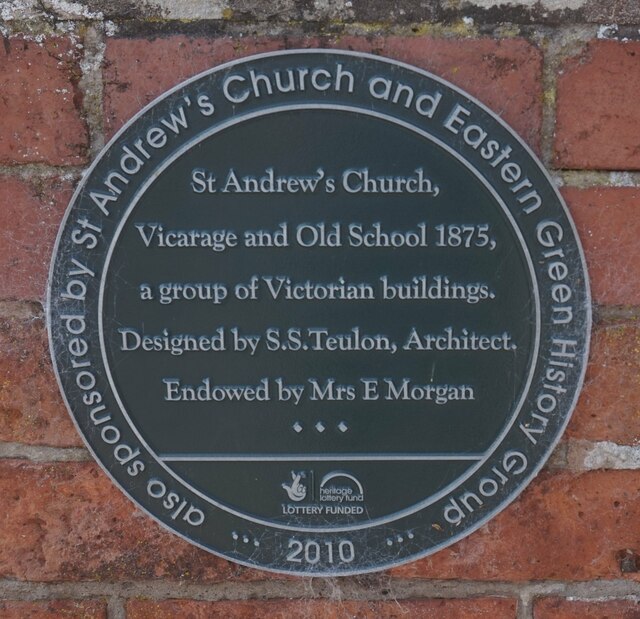
Plaque at St Andrew's Church, Upper Eastern Green
St Andrew's Church, Eastern Green This parish church of the Church of England stands on the western edge of Coventry, surrounded by fields. A red brick building in the Gothic revival style, it opened in 1875, according to the parish website, which doesn't mention the name of the architect <span class="nowrap"><a title="https://standrewseg.co.uk/information/history-of-st-andrews-church/" rel="nofollow ugc noopener" href="https://standrewseg.co.uk/information/history-of-st-andrews-church/">Link</a><img style="margin-left:2px;" alt="External link" title="External link - shift click to open in new window" src="https://s1.geograph.org.uk/img/external.png" width="10" height="10"/></span> . 

Two Giant Sequoia (Sequoiadendron giganteum) trees, otherwise known as Giant Redwood or Wellingtonia, were planted in the churchyard, on either side of the path from gate to church. One has been felled and only a huge stump remains. The other now towers over the church, and can be seen to the left of the steeple.
St Andrew's Church, Eastern Green
This parish church of the Church of England stands on the western edge of Coventry, surrounded by fields. A red brick building in the Gothic revival style, it opened in 1875, according to the parish website, which doesn't mention the name of the architect LinkExternal link . Two Giant Sequoia (Sequoiadendron giganteum) trees, otherwise known as Giant Redwood or Wellingtonia, were planted in the churchyard, on either side of the path from gate to church. One has been felled and only a huge stump remains. The other now towers over the church, and can be seen to the left of the steeple.
Gate, St Andrew's Church, Eastern Green Upper Eastern Green Lane can be seen through the churchyard gates and their decorative lamp overthrow. For more on the church itself see <a href="https://www.geograph.org.uk/photo/7524219">SP2780 : St Andrew's Church, Eastern Green</a>.
Gate, St Andrew's Church, Eastern Green
Upper Eastern Green Lane can be seen through the churchyard gates and their decorative lamp overthrow. For more on the church itself see SP2780 : St Andrew's Church, Eastern Green.
Oak tree and fencing, Pickford The fencing indicates that this still-rural part of western Coventry, to the south of the A45, is soon to be built up with housing.
Oak tree and fencing, Pickford
The fencing indicates that this still-rural part of western Coventry, to the south of the A45, is soon to be built up with housing.
Oak tree by building site fence, Pickford The fence indicates that these fields on the western edge of Coventry, south of the A45, are soon to be built up with housing. I hope the mature trees will survive the earth moving and will be incorporated into the new development. Having misread the map I was on the wrong side of the hedge; the public footpath runs along the other side, off to the right of the photo.
Oak tree by building site fence, Pickford
The fence indicates that these fields on the western edge of Coventry, south of the A45, are soon to be built up with housing. I hope the mature trees will survive the earth moving and will be incorporated into the new development. Having misread the map I was on the wrong side of the hedge; the public footpath runs along the other side, off to the right of the photo.
Field path from Flint's Green to Upper Eastern Green The path runs from Back Lane to Church Lane by Eastern Green church.
Field path from Flint's Green to Upper Eastern Green
The path runs from Back Lane to Church Lane by Eastern Green church.
Field path with ash tree, Upper Eastern Green We are on the western edge of Coventry; the city boundary passes between the viewer and the tree. The path runs between Flint's Green and Upper Eastern Green in the Meriden Gap between Coventry and Birmingham, part of the ancient countryside of Arden.
Field path with ash tree, Upper Eastern Green
We are on the western edge of Coventry; the city boundary passes between the viewer and the tree. The path runs between Flint's Green and Upper Eastern Green in the Meriden Gap between Coventry and Birmingham, part of the ancient countryside of Arden.
Upper Eastern Green, seen from Church Lane The grand Victorian house seen across a field of oilseed rape presumably is, or was, the vicarage. The Coventry Society tells us that Eastern Green was historically the green at the eastern end of Meriden parish. Today it forms part of Coventry, at the western edge of the city <span class="nowrap"><a title="https://www.coventrysociety.org.uk/coventry-neighbourhoods/eastern-green/" rel="nofollow ugc noopener" href="https://www.coventrysociety.org.uk/coventry-neighbourhoods/eastern-green/">Link</a><img style="margin-left:2px;" alt="External link" title="External link - shift click to open in new window" src="https://s1.geograph.org.uk/img/external.png" width="10" height="10"/></span> .
Upper Eastern Green, seen from Church Lane
The grand Victorian house seen across a field of oilseed rape presumably is, or was, the vicarage. The Coventry Society tells us that Eastern Green was historically the green at the eastern end of Meriden parish. Today it forms part of Coventry, at the western edge of the city LinkExternal link .
Parkhill Bus Terminus Get a bus here to the centre of Coventry or, in the other Direction, via Birmingham Airport, to Birmingham.
Parkhill Bus Terminus
Get a bus here to the centre of Coventry or, in the other Direction, via Birmingham Airport, to Birmingham.
Farmland near Allesley Green Looking South from the footpath by the golf course. This crop was planted in the Autumn. I believe it is wheat - we shall see.
Farmland near Allesley Green
Looking South from the footpath by the golf course. This crop was planted in the Autumn. I believe it is wheat - we shall see.
Farmland Near Upper Eastern Green On the skyline (left) you can just see the Agco (ex Massey Ferguson) tower block. Further right on the skyline are three large conifers obscuring St. Andrew's Church, Eastern Green.
Farmland Near Upper Eastern Green
On the skyline (left) you can just see the Agco (ex Massey Ferguson) tower block. Further right on the skyline are three large conifers obscuring St. Andrew's Church, Eastern Green.
Playground by the Parkhill Estate
Farmland near Brook Farm Looking SW across one field to the footbridge over the brook (tributary of Pickford Brook).Ice in the stone trough.
Farmland near Brook Farm
Looking SW across one field to the footbridge over the brook (tributary of Pickford Brook).Ice in the stone trough.
Footpath by Unnamed Brook. Walking towards Allesley Green. The brook is a tributary of Pickford Brook.
Footpath by Unnamed Brook.
Walking towards Allesley Green. The brook is a tributary of Pickford Brook.
Footbridge Across the Brook Near Allesley Green The unnamed brook is a tributary of Pickford Brook. After the footbridge the path turns east towards Allesley Green (Parkhill Estate).
Footbridge Across the Brook Near Allesley Green
The unnamed brook is a tributary of Pickford Brook. After the footbridge the path turns east towards Allesley Green (Parkhill Estate).
Farmland west of Allesley Green Arable land, new crop just showing. The building on the skyline (centre) is the top of the ex-Massey Ferguson tower block.
Farmland west of Allesley Green
Arable land, new crop just showing. The building on the skyline (centre) is the top of the ex-Massey Ferguson tower block.
Allesley Green from Park Hill Lane A 1980s housing estate.  Just visible on the skyline is the woodland north of Meriden.
Allesley Green from Park Hill Lane
A 1980s housing estate. Just visible on the skyline is the woodland north of Meriden.
Show me another place!

Tilehill Wood is located at Grid Ref: SP2778 (Lat: 52.407742, Lng: -1.5913824)

Unitary Authority: Coventry

Police Authority: West Midlands

What 3 Words

///sweat.mess.opera. Near Berkswell, West Midlands

Related Wikis

Tile Hill Wood

Tile Hill Wood is a wood between Hawthorn Lane and Banner Lane in the Tile Hill area of Coventry, England. It has been designated as a Site of Special...

Massey Ferguson F.C.

Massey Ferguson Sports & Social F.C. are a football club based in Coventry, England. They joined the Midland Combination Division Two in 1993. They currently...

West Coventry Academy

West Coventry Academy is a co-educational secondary school and sixth form located in the Tile Hill area of Coventry, West Midlands, England. It was formed...

Woodlands Academy, Coventry

Woodlands Academy (formerly The Woodlands School and Sports College) was a boys secondary school situated in west Coventry in the West Midlands, England...

Nearby Amenities

Located within 500m of 52.407742,-1.5913824
Bus Stop
Banner Lane / Wickman'S
Bus: yes
Naptan AtcoCode: 43000076401
Naptan Bearing: S
Naptan BusStopType: MKD
Naptan CommonName: Wickman's
Naptan Indicator: opp
Naptan NaptanCode: nwmgajaj
Naptan PlusbusZoneRef: BHAMNWS
Naptan Status: ACT
Naptan StopType: BCT
Naptan Street: BANNER LANE
Naptan Towards: Tanyard Farm
Naptan Verified: no
Public Transport: platform
Route Ref: 6A
Source: WMCA
Lat/Long: 52.4061781/-1.5963107
Bus Stop
Banner Lane / Wickman'S
Bus: yes
Naptan AtcoCode: 43000076402
Naptan Bearing: N
Naptan BusStopType: MKD
Naptan CommonName: Wickman's
Naptan Indicator: adj
Naptan NaptanCode: nwmgajam
Naptan PlusbusZoneRef: BHAMNWS
Naptan Status: ACT
Naptan StopType: BCT
Naptan Street: BANNER LANE
Naptan Towards: City Centre
Naptan Verified: no
Public Transport: platform
Route Ref: 6A
Source: WMCA
Lat/Long: 52.4062763/-1.5967077
Bus Stop
Banner Lane / Bannerbrook Park
Bus: yes
Naptan AtcoCode: 43000076501
Naptan Bearing: S
Naptan BusStopType: MKD
Naptan CommonName: Bannerbrook Park
Naptan Indicator: opp
Naptan NaptanCode: nwmgajap
Naptan PlusbusZoneRef: BHAMNWS
Naptan Status: ACT
Naptan StopType: BCT
Naptan Street: BANNER LANE
Naptan Towards: Tanyard Farm
Naptan Verified: no
Public Transport: platform
Route Ref: 6A
Source: WMCA
Lat/Long: 52.4092488/-1.5968585
Bus Stop
Banner Lane / Bannerbrook Park
Bus: yes
Naptan AtcoCode: 43000076502
Naptan Bearing: N
Naptan BusStopType: MKD
Naptan CommonName: Bannerbrook Park
Naptan Indicator: adj
Naptan NaptanCode: nwmgajat
Naptan PlusbusZoneRef: BHAMNWS
Naptan Status: ACT
Naptan StopType: BCT
Naptan Street: BANNER LANE
Naptan Towards: City Centre
Naptan Verified: no
Public Transport: platform
Route Ref: 6A
Source: WMCA
Lat/Long: 52.4095777/-1.5970637
Nutbrook Ave / Tile Hill School
Naptan AtcoCode: 43000076901
Naptan Bearing: N
Naptan BusStopType: CUS
Naptan CommonName: Tile Hill School
Naptan Indicator: o/s
Naptan NaptanCode: nwmgajdp
Naptan PlusbusZoneRef: BHAMNWS
Naptan Status: ACT
Naptan StopType: BCT
Naptan Street: NUTBROOK AVE
Naptan Verified: no
Source: WMCA
Lat/Long: 52.404257/-1.589213
Parking
Access: yes
Fee: no
Parking: surface
Lat/Long: 52.407157/-1.59655
Crossing
Crossing: unmarked
Crossing Island: no
Crossing Markings: no
Kerb: lowered
Tactile Paving: no
Lat/Long: 52.4053592/-1.5855574
Tree face
Lat/Long: 52.4085511/-1.5881146
A block
Access: private
Entrance: yes
Lat/Long: 52.4092643/-1.597988
B block
Access: private
Entrance: yes
Lat/Long: 52.4095694/-1.597367
C block
Access: private
Entrance: yes
Lat/Long: 52.4100291/-1.597471
Access: private
Entrance: yes
Lat/Long: 52.4093307/-1.5973873
Access: private
Entrance: yes
Lat/Long: 52.4099483/-1.5973726
Crossing
Crossing: uncontrolled
Crossing Island: yes
Tactile Paving: yes
Lat/Long: 52.4087539/-1.596946
Crossing
Crossing: uncontrolled
Tactile Paving: yes
Lat/Long: 52.4090018/-1.5984509
Crossing
Crossing: uncontrolled
Crossing Island: yes
Tactile Paving: yes
Lat/Long: 52.4089424/-1.597186
Crossing
Crossing: uncontrolled
Kerb: lowered
Lat/Long: 52.4066498/-1.5966047
Crossing
Crossing: uncontrolled
Tactile Paving: yes
Lat/Long: 52.4069662/-1.5978903
Crossing
Crossing: uncontrolled
Tactile Paving: yes
Lat/Long: 52.4069744/-1.5979225
Bus Stop
Delius St / Aldrich Avenue
Bus: yes
Naptan AtcoCode: 43001077702
Naptan Bearing: NW
Naptan BusStopType: MKD
Naptan CommonName: Aldrich Avenue
Naptan Indicator: adj
Naptan NaptanCode: nwmwgdtg
Naptan Status: ACT
Naptan StopType: BCT
Naptan Street: DELIUS ST
Naptan Towards: Eastern Green
Public Transport: platform
Source: WMCA
Lat/Long: 52.4089418/-1.5844915
Bus Stop
Delius St / Aldrich Avenue
Bus: yes
Naptan AtcoCode: 43001077701
Naptan Bearing: SE
Naptan BusStopType: MKD
Naptan CommonName: Aldrich Avenue
Naptan Indicator: opp
Naptan NaptanCode: nwmwdgad
Naptan Status: ACT
Naptan StopType: BCT
Naptan Street: DELIUS ST
Naptan Towards: Cannon Park
Public Transport: platform
Source: WMCA
Lat/Long: 52.4091304/-1.5844309
Generator Method: photovoltaic
Generator Output Electricity: yes
Generator Source: solar
Generator Type: solar_photovoltaic_panel
Location: roof
Power: generator
Lat/Long: 52.4073574/-1.584684
Generator Method: photovoltaic
Generator Output Electricity: yes
Generator Source: solar
Generator Type: solar_photovoltaic_panel
Location: roof
Power: generator
Lat/Long: 52.4067847/-1.5844238
Generator Method: photovoltaic
Generator Output Electricity: yes
Generator Source: solar
Generator Type: solar_photovoltaic_panel
Location: roof
Power: generator
Lat/Long: 52.4068011/-1.5843353
Generator Method: photovoltaic
Generator Output Electricity: yes
Generator Source: solar
Generator Type: solar_photovoltaic_panel
Location: roof
Power: generator
Lat/Long: 52.4068076/-1.5842253
Generator Method: photovoltaic
Generator Output Electricity: yes
Generator Source: solar
Generator Type: solar_photovoltaic_panel
Location: roof
Power: generator
Lat/Long: 52.4042189/-1.5871891
Generator Method: photovoltaic
Generator Output Electricity: yes
Generator Source: solar
Generator Type: solar_photovoltaic_panel
Location: roof
Power: generator
Lat/Long: 52.4048064/-1.5870523
Generator Method: photovoltaic
Generator Output Electricity: yes
Generator Source: solar
Generator Type: solar_photovoltaic_panel
Location: roof
Power: generator
Lat/Long: 52.4079759/-1.585553
Generator Method: photovoltaic
Generator Output Electricity: yes
Generator Source: solar
Generator Type: solar_photovoltaic_panel
Location: roof
Power: generator
Lat/Long: 52.4072576/-1.5846947
Generator Method: photovoltaic
Generator Output Electricity: yes
Generator Source: solar
Generator Type: solar_photovoltaic_panel
Location: roof
Power: generator
Lat/Long: 52.4072789/-1.5846276
Generator Method: photovoltaic
Generator Output Electricity: yes
Generator Source: solar
Generator Type: solar_photovoltaic_panel
Location: roof
Power: generator
Lat/Long: 52.4073443/-1.5847403
Generator Method: photovoltaic
Generator Output Electricity: yes
Generator Source: solar
Generator Type: solar_photovoltaic_panel
Location: roof
Power: generator
Lat/Long: 52.4098984/-1.5857032
The data included in this document is from www.openstreetmap.org. The data is made available under ODbL.

Have you been to Tilehill Wood?

Leave your review of Tilehill Wood below (or comments, questions and feedback).