Bailey's Whins

Wood, Forest in Yorkshire Harrogate

England

Bailey's Whins

St. Mary's Church Stainburn Stainburn St Mary, the small church is Norman with a Norman Font and the Porch is Medieval, the key is available to view the Church from Home Farm
St. Mary's Church Stainburn Credit: Mick Melvin

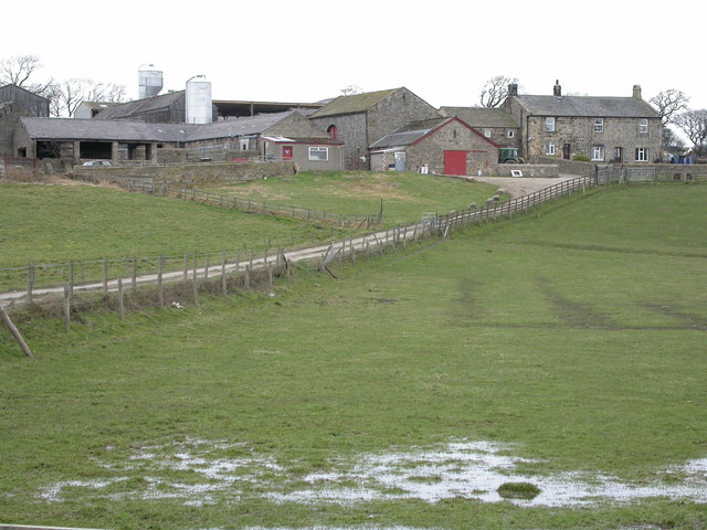
Bailey's Whins is a scenic woodland located in Yorkshire, England. Situated in the heart of the county, this beautiful forest is known for its tranquil ambiance and lush greenery. Spanning approximately 100 acres, Bailey's Whins offers a peaceful retreat for nature enthusiasts and outdoor adventurers alike.

The woodland is home to a diverse range of tree species, including oak, beech, and birch, creating a rich tapestry of colors throughout the seasons. The forest floor is adorned with an array of wildflowers and ferns, adding to its natural beauty. Walking trails wind their way through the woods, allowing visitors to explore the area at their own pace. These paths provide a wonderful opportunity to observe the local wildlife, such as deer, foxes, and a variety of bird species.

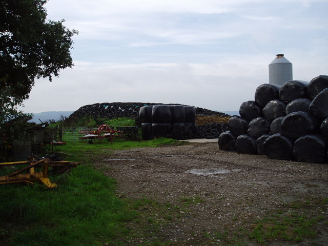
Bailey's Whins is not only a haven for nature lovers but also a popular spot for recreational activities. The forest offers ample space for picnicking, making it an ideal destination for families and groups of friends. Additionally, there are designated areas for camping and barbecuing, allowing visitors to extend their stay and fully immerse themselves in the peaceful surroundings.

The woodland is well-maintained and managed by local authorities, ensuring a safe and enjoyable experience for all visitors. Information boards are scattered throughout the forest, providing educational insights into the flora and fauna that call Bailey's Whins their home.

Overall, Bailey's Whins is a picturesque woodland in Yorkshire, offering its visitors a chance to escape the bustling city life and connect with nature in a serene and captivating environment.

If you have any feedback on the listing, please let us know in the comments section below.

Bailey's Whins Images

Images are sourced within 2km of 53.92589/-1.6077313 or Grid Reference SE2547. Thanks to Geograph Open Source API. All images are credited.

St. Mary's Church Stainburn Stainburn St Mary, the small church is Norman with a Norman Font and the Porch is Medieval, the key is available to view the Church from Home Farm
St. Mary's Church Stainburn
Stainburn St Mary, the small church is Norman with a Norman Font and the Porch is Medieval, the key is available to view the Church from Home Farm
Home Farm Stainburn This view of Home Farm Stainburn is taken from the footpath to Merrybank Lane
Home Farm Stainburn
This view of Home Farm Stainburn is taken from the footpath to Merrybank Lane
Almscliff Crags This view taken from below Crag Farm, the crag is one of the most popular climbing areas in the North of England.
Almscliff Crags
This view taken from below Crag Farm, the crag is one of the most popular climbing areas in the North of England.
Almscliff Crag North West Face The North West Face of the crag has many famous climbs i.e Wall of Horrors, All Quiet and my first Rock climb Central Climb.
Almscliff Crag North West Face
The North West Face of the crag has many famous climbs i.e Wall of Horrors, All Quiet and my first Rock climb Central Climb.
Almscliff Crag A prominent Wharfedale landmark, seen from Otley Chevin on the opposite side of the valley.
Almscliff Crag
A prominent Wharfedale landmark, seen from Otley Chevin on the opposite side of the valley.
Stainburn from Almscliffe The view from the Almscliffe Crag.
Stainburn from Almscliffe
The view from the Almscliffe Crag.
Riffa Wood Eastern boundary of Riffa Wood from the A658 Harrogate/Bradford Road
Riffa Wood
Eastern boundary of Riffa Wood from the A658 Harrogate/Bradford Road
Riffa Farm A North Yorkshire Dairy Farm.
Riffa Farm
A North Yorkshire Dairy Farm.
Huby Picture taken on rather a dull rainy May evening in Huby, looking west towards Weeton Station railway bridge.
Huby
Picture taken on rather a dull rainy May evening in Huby, looking west towards Weeton Station railway bridge.
Gravelly Lane, near Huby Looking west towards Round Hill from its junction with the road to Almscliffe Crag - it's a dead end, but beautiful on a May evening!
Gravelly Lane, near Huby
Looking west towards Round Hill from its junction with the road to Almscliffe Crag - it's a dead end, but beautiful on a May evening!
Castley Farm Looking south towards the hamlet of Castley which nestles at the very end of Arthington Viaduct.
Castley Farm
Looking south towards the hamlet of Castley which nestles at the very end of Arthington Viaduct.
Bogridge Farm Viewed looking west from the slopes of Round Hill (through a barbed wire fence)
Bogridge Farm
Viewed looking west from the slopes of Round Hill (through a barbed wire fence)
Huby Methodist Church This Church is on the western boundary of the O/S grid which it occupies, to the north of centre
Huby Methodist Church
This Church is on the western boundary of the O/S grid which it occupies, to the north of centre
Stainburn, St Mary's Church ( another view) This Church is now disused and cared for by The Church Conservation Trust.
Stainburn, St Mary's Church ( another view)
This Church is now disused and cared for by The Church Conservation Trust.
A cluttered farmyard Part of the yard of Hilltop Farm between the villages of Leathley and Stainburn.
A cluttered farmyard
Part of the yard of Hilltop Farm between the villages of Leathley and Stainburn.
Field near Townend Farm, Stainburn The rocky outcrop of Almscliff Crag looms over this newly cut meadow.
Field near Townend Farm, Stainburn
The rocky outcrop of Almscliff Crag looms over this newly cut meadow.
Crag Lane Crag Lane leading towards the village of North Rigton.
Crag Lane
Crag Lane leading towards the village of North Rigton.
Old Milestone This much eroded old milestone stands by the junction of the A658 and Wescoe Hill Lane leading to the village of Weeton. On this face it says: "The Road to Bradford, ? miles" and is dated 1743. On another side it reads:" The Road to Otley ? Miles" and "The Road to Knaresborough 8 Miles."
Old Milestone
This much eroded old milestone stands by the junction of the A658 and Wescoe Hill Lane leading to the village of Weeton. On this face it says: "The Road to Bradford, ? miles" and is dated 1743. On another side it reads:" The Road to Otley ? Miles" and "The Road to Knaresborough 8 Miles."
Show me another place!

Bailey's Whins is located at Grid Ref: SE2547 (Lat: 53.92589, Lng: -1.6077313)

Division: West Riding

Administrative County: North Yorkshire

District: Harrogate

Police Authority: North Yorkshire

What 3 Words

///sketches.writings.commuted. Near Stainburn, North Yorkshire

Related Wikis

Stainburn

Stainburn is a village and civil parish in the Harrogate district of North Yorkshire, England, 10 miles (16 km) north of Leeds. The population of the civil...

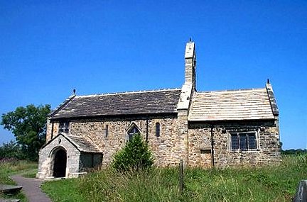
St Mary's Church, Stainburn

St Mary's Church is a redundant Anglican church in the village of Stainburn, North Yorkshire, England. It is recorded in the National Heritage List for...
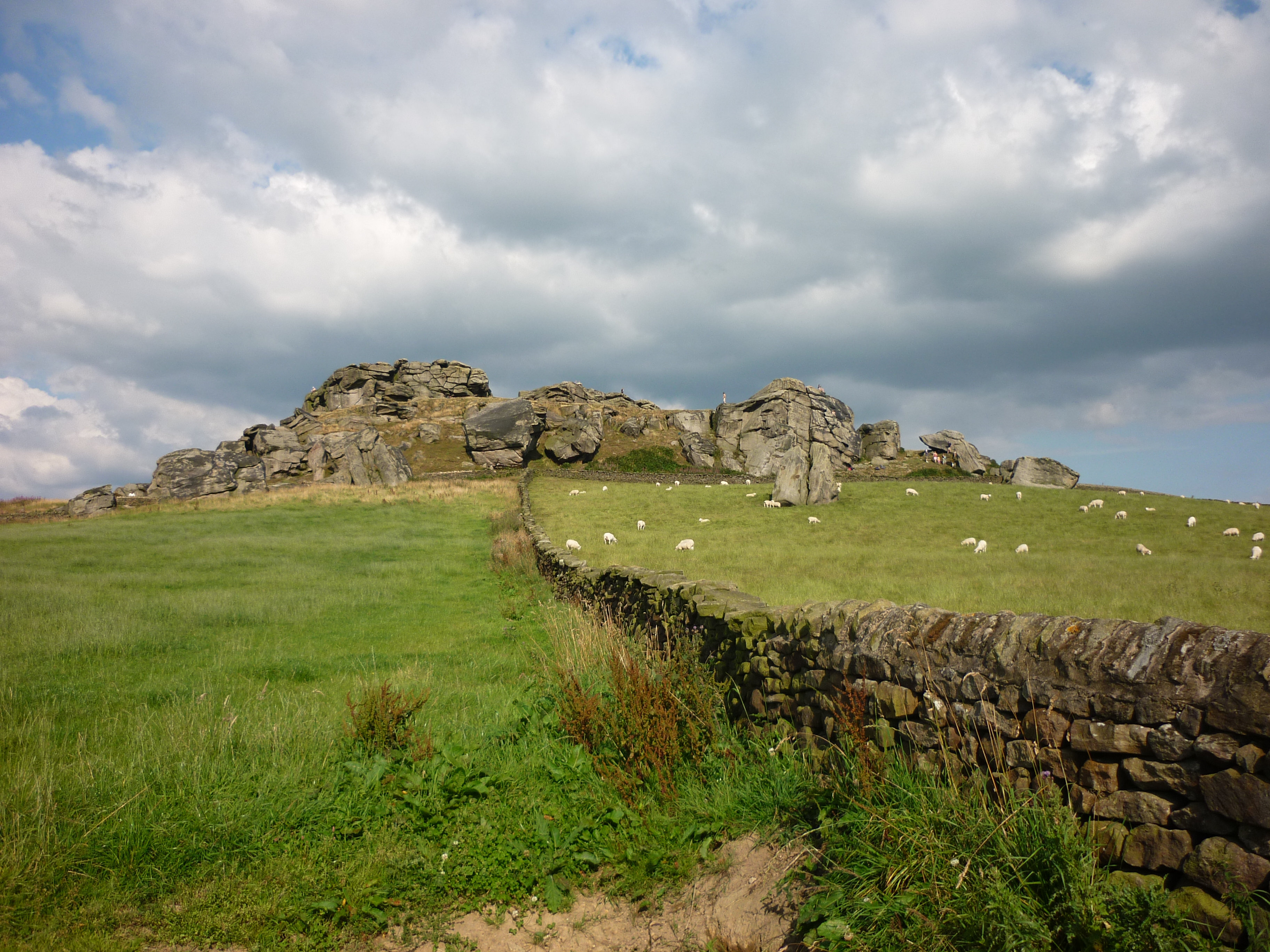
Almscliffe Crag

Almscliffe Crag, or Almscliff Crag, also known as Great Almscliff Crag to distinguish from Little Almscliff, 3 miles (5 km) north west, is a Millstone...

Huby, Harrogate

Huby is a village in the Harrogate district of North Yorkshire that lies approximately 5 miles (8 km) south of the town of Harrogate and 8.63 miles (13...

Weeton railway station

Weeton railway station serves the villages of Weeton and Huby in North Yorkshire, England. It is located on the Harrogate Line 11.5 miles (19 km) north...

Braythorn

Braythorn is a village in the Harrogate district of North Yorkshire, England.

A658 road

The A658 is a road in Yorkshire, UK. == Route == It runs from Bradford, West Yorkshire (53.7949°N 1.7487°W / 53.7949; -1.7487 (A658 road (southwestern...

Castley

Castley is a village and civil parish in the Harrogate district of North Yorkshire, England. It lies on a bend in the River Wharfe about 10 miles (16 km...

Nearby Amenities

Located within 500m of 53.92589,-1.6077313
Round Hill
Ele: 130
Ele Ft: 425
Natural: peak
Source: NPE;os_25k_firstseries
Lat/Long: 53.9236165/-1.6073732
Gravelly Hill
Natural: peak
Source: OS Yorkshire 187, 1851
Lat/Long: 53.922056/-1.6059769
Cellar Hill
Ele Ft: 350
Natural: peak
Source: NPE;os_25k_firstseries
Lat/Long: 53.9233484/-1.6125646
Bench
Lat/Long: 53.9218499/-1.6057491
Barrier: cattle_grid
Lat/Long: 53.9237763/-1.6107517
Generator Method: photovoltaic
Generator Output Electricity: yes
Generator Source: solar
Generator Type: solar_photovoltaic_panel
Power: generator
Lat/Long: 53.9232173/-1.6111694
Power: pole
Lat/Long: 53.924989/-1.6102722
Power: pole
Lat/Long: 53.9255197/-1.6097572
Power: pole
Lat/Long: 53.9243478/-1.6108838
Power: pole
Lat/Long: 53.9299102/-1.606214
Power: pole
Lat/Long: 53.9268606/-1.608451
Power: pole
Lat/Long: 53.9262194/-1.6090974
Power: pole
Lat/Long: 53.9295518/-1.6051574
Power: pole
Lat/Long: 53.92811/-1.6042723
Power: pole
Lat/Long: 53.9277673/-1.6054095
Power: pole
Lat/Long: 53.9274135/-1.6065843
Power: pole
Lat/Long: 53.9273454/-1.6038162
Power: pole
Lat/Long: 53.9287701/-1.6046746
Barrier: cattle_grid
Source: survey
Lat/Long: 53.9224797/-1.6060219
Power: pole
Lat/Long: 53.9239049/-1.611321
The data included in this document is from www.openstreetmap.org. The data is made available under ODbL.

Have you been to Bailey's Whins?

Leave your review of Bailey's Whins below (or comments, questions and feedback).