Dedham Heath

Settlement in Essex Colchester

England

Dedham Heath

War Memorial in the centre of Dedham
War Memorial in the centre of Dedham Credit: Chris Holifield

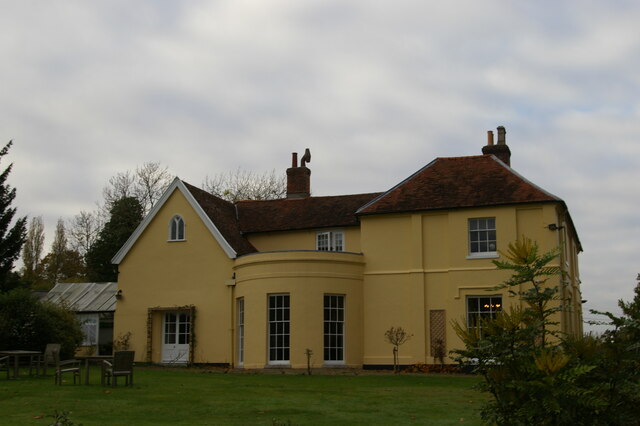
Dedham Heath is a picturesque village located in the county of Essex, England. Situated on the northeast edge of Dedham Vale, it is renowned for its natural beauty and is considered one of the most attractive areas in the region. The village is nestled amidst rolling hills, meandering rivers, and lush green fields, creating a tranquil and idyllic setting.

The main feature of Dedham Heath is its vast heathland, which stretches over 300 acres and is a designated Site of Special Scientific Interest (SSSI). This heathland is characterized by its wide open spaces, heather-covered slopes, and scattered trees, creating a unique and diverse ecosystem. It is home to a wide range of wildlife, including various species of birds, insects, and small mammals, making it a popular destination for nature enthusiasts and birdwatchers.

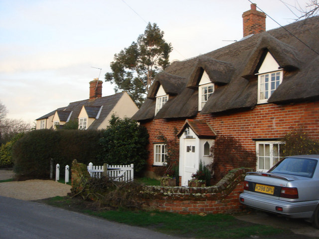
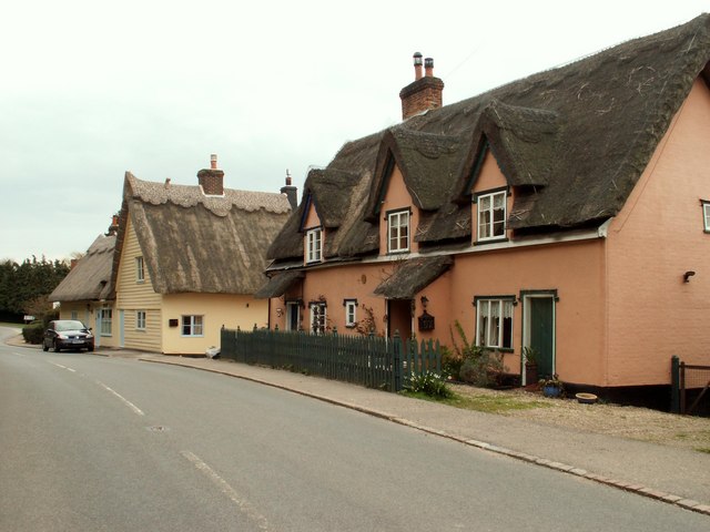
In addition to its natural attractions, Dedham Heath boasts a rich history and cultural heritage. The village itself dates back to medieval times and is dotted with historic buildings, such as the 15th-century church of St. Mary the Virgin. The charming cottages and traditional houses that line the streets further add to the village's charm and character.

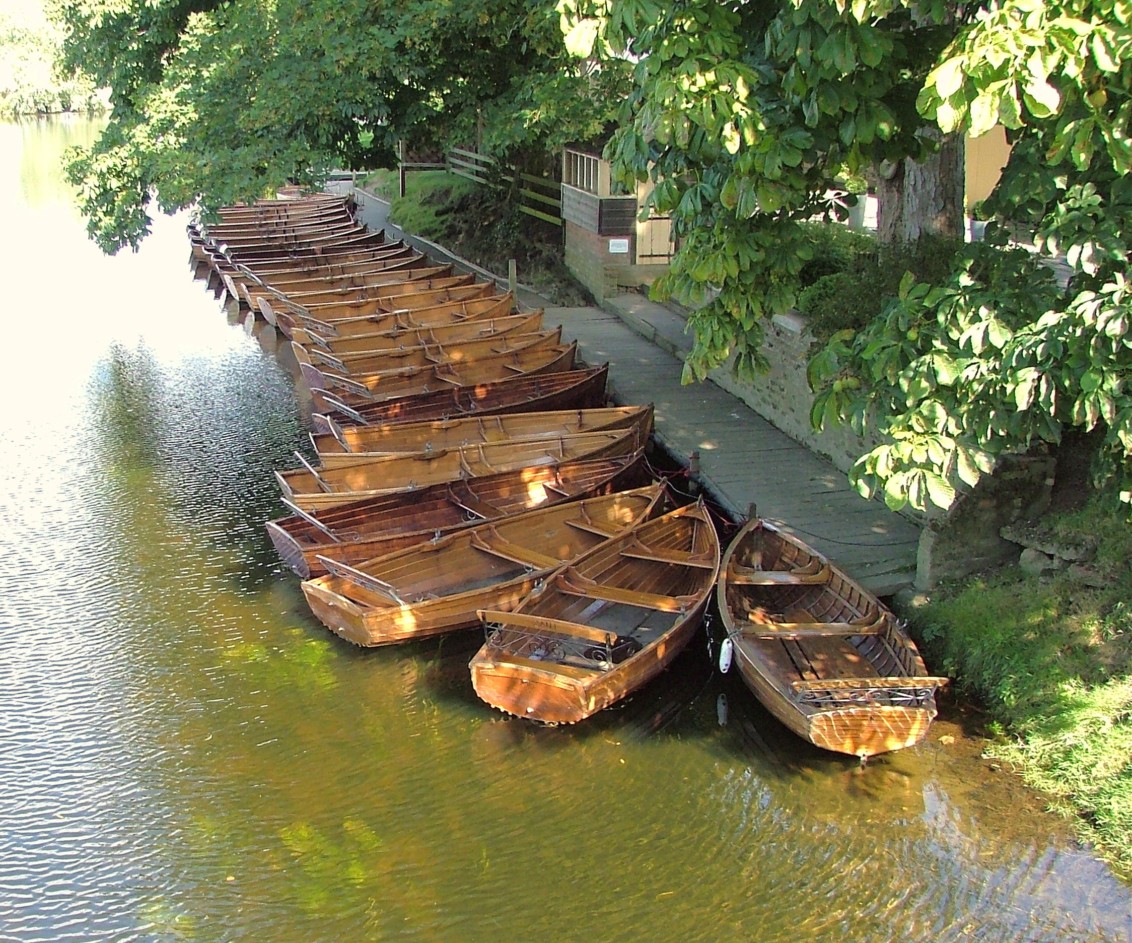
Dedham Heath offers a range of recreational activities for visitors and locals alike. The area is crisscrossed with footpaths and bridleways, making it ideal for walkers, cyclists, and horse riders. The nearby River Stour also provides opportunities for boating, fishing, and picnicking along its picturesque banks.

Overall, Dedham Heath is a captivating and picturesque village that offers a perfect blend of natural beauty, history, and outdoor activities. It is a true gem in the heart of Essex, attracting visitors from far and wide.

If you have any feedback on the listing, please let us know in the comments section below.

Dedham Heath Images

Images are sourced within 2km of 51.943283/0.99662183 or Grid Reference TM0631. Thanks to Geograph Open Source API. All images are credited.

War Memorial in the centre of Dedham
View of ivy-clad houses on Brook Street in Dedham Looking north.
View of ivy-clad houses on Brook Street in Dedham
Looking north.
View of an ivy-clad house on Brook Street in Dedham Looking north.
View of an ivy-clad house on Brook Street in Dedham
Looking north.
View of an ivy-clad house on Brook Street in Dedham #2 Looking north.
View of an ivy-clad house on Brook Street in Dedham #2
Looking north.
View of a templar house on Brook Street in Dedham Looking north.
View of a templar house on Brook Street in Dedham
Looking north.
View of Dedham Parish Church from Brook Street Looking north-northwest.
View of Dedham Parish Church from Brook Street
Looking north-northwest.
View along Brook Street from outside The Sun Inn Looking north-northwest.
View along Brook Street from outside The Sun Inn
Looking north-northwest.
View of the vicarage of Dedham Parish Church from Brook Street Looking south-southeast.
View of the vicarage of Dedham Parish Church from Brook Street
Looking south-southeast.
View of the spire of Dedham Parish Church towering above the vicarage from Brook Street Looking north-northwest
View of the spire of Dedham Parish Church towering above the vicarage from Brook Street
Looking north-northwest
View of the spire of Dedham Parish Church from Brook Street Looking south-southeast.
View of the spire of Dedham Parish Church from Brook Street
Looking south-southeast.
View of the Dedham War Memorial from Brook Street Looking south-southeast.
View of the Dedham War Memorial from Brook Street
Looking south-southeast.
View of a large green house on Brook Street Looking south-southeast.
View of a large green house on Brook Street
Looking south-southeast.
Former home of Sir Alfred Munnings, Dedham Sir Alfred Munnings (1878-1959) was born in Suffolk and trained as a painter at the Norwich School of Art and in Paris.  He is best known for his paintings of horses, and for his 1949 valedictory address as President of the Royal Academy in which he attacked Picasso and modern art in general; both facts present something of a caricature, in that Munnings was open to influences seen as modern and shocking in their day (much of his work is influenced by Impressionism, and his poster work is reminiscent of Lautrec) and his subject matter is more varied than the popular belief would have it, including rural scenes and depictions of Romany life.  After his death this, his home, became the Munnings Art Museum, housing many of his paintings and showing the house as he lived in it.
Former home of Sir Alfred Munnings, Dedham
Sir Alfred Munnings (1878-1959) was born in Suffolk and trained as a painter at the Norwich School of Art and in Paris. He is best known for his paintings of horses, and for his 1949 valedictory address as President of the Royal Academy in which he attacked Picasso and modern art in general; both facts present something of a caricature, in that Munnings was open to influences seen as modern and shocking in their day (much of his work is influenced by Impressionism, and his poster work is reminiscent of Lautrec) and his subject matter is more varied than the popular belief would have it, including rural scenes and depictions of Romany life. After his death this, his home, became the Munnings Art Museum, housing many of his paintings and showing the house as he lived in it.
Dedham, St Mary the Virgin
Field near the River Stour, at Flatford
Brook Cottages, Dedham <span class="nowrap"><a title="https://historicengland.org.uk/listing/the-list/list-entry/1239173?section=official-list-entry" rel="nofollow ugc noopener" href="https://historicengland.org.uk/listing/the-list/list-entry/1239173?section=official-list-entry">Link</a><img style="margin-left:2px;" alt="External link" title="External link - shift click to open in new window" src="https://s1.geograph.org.uk/img/external.png" width="10" height="10"/></span>
Brook Cottages, Dedham
Brook House and 1 High Street, Dedham <span class="nowrap"><a title="https://historicengland.org.uk/listing/the-list/list-entry/1239284?section=official-list-entry" rel="nofollow ugc noopener" href="https://historicengland.org.uk/listing/the-list/list-entry/1239284?section=official-list-entry">Link</a><img style="margin-left:2px;" alt="External link" title="External link - shift click to open in new window" src="https://s1.geograph.org.uk/img/external.png" width="10" height="10"/></span> and <span class="nowrap"><a title="https://historicengland.org.uk/listing/the-list/list-entry/1239312?section=official-list-entry" rel="nofollow ugc noopener" href="https://historicengland.org.uk/listing/the-list/list-entry/1239312?section=official-list-entry">Link</a><img style="margin-left:2px;" alt="External link" title="External link - shift click to open in new window" src="https://s1.geograph.org.uk/img/external.png" width="10" height="10"/></span>
Brook House and 1 High Street, Dedham
LinkExternal link and LinkExternal link
5 and 6 High Street, Gould House and Dale Brook, Dedham <span class="nowrap"><a title="https://historicengland.org.uk/listing/the-list/list-entry/1239317?section=official-list-entry" rel="nofollow ugc noopener" href="https://historicengland.org.uk/listing/the-list/list-entry/1239317?section=official-list-entry">Link</a><img style="margin-left:2px;" alt="External link" title="External link - shift click to open in new window" src="https://s1.geograph.org.uk/img/external.png" width="10" height="10"/></span> and <span class="nowrap"><a title="https://historicengland.org.uk/listing/the-list/list-entry/1273803?section=official-list-entry" rel="nofollow ugc noopener" href="https://historicengland.org.uk/listing/the-list/list-entry/1273803?section=official-list-entry">Link</a><img style="margin-left:2px;" alt="External link" title="External link - shift click to open in new window" src="https://s1.geograph.org.uk/img/external.png" width="10" height="10"/></span> and <span class="nowrap"><a title="https://historicengland.org.uk/listing/the-list/list-entry/1239313?section=official-list-entry" rel="nofollow ugc noopener" href="https://historicengland.org.uk/listing/the-list/list-entry/1239313?section=official-list-entry">Link</a><img style="margin-left:2px;" alt="External link" title="External link - shift click to open in new window" src="https://s1.geograph.org.uk/img/external.png" width="10" height="10"/></span>
5 and 6 High Street, Gould House and Dale Brook, Dedham
LinkExternal link and LinkExternal link and LinkExternal link
Show me another place!

Dedham Heath is located at Grid Ref: TM0631 (Lat: 51.943283, Lng: 0.99662183)

Administrative County: Essex

District: Colchester

Police Authority: Essex

What 3 Words

///rapid.fruitcake.precluded. Near Dedham, Essex

Nearby Locations

Dedham Heath Dedham Heath

Related Wikis

Dedham Heath

Dedham Heath, known locally as The Heath, is a hamlet in the civil parish of Dedham, in the Colchester district, in the county of Essex, England. In 2021...

Castle House, Dedham

Castle House in Dedham, Essex, England was the home of Sir Alfred Munnings from 1919 till his death in 1959. Architecturally the building contains a mixture...

Lamb Corner

Lamb Corner is a hamlet on the B1029 road, in the civil parish of Dedham in the Colchester district, in the county of Essex, England. Lamb Corner formerly...

Ardleigh Heath

Ardleigh Heath is a hamlet on the B1029 road, in the civil parish of Ardleigh, in the Tendring District of the county of Essex, England. It is located...

Dedham, Essex

Dedham is a village in the City of Colchester district of Essex, England. It is near the River Stour, which is the border of Essex and Suffolk. The nearest...

Ardleigh

Ardleigh is a village and civil parish in Essex, England. It is situated approximately 4 miles (6 km) northeast from the centre of Colchester and 26 miles...

Veolia Water East

Veolia Water East, formerly known as Tendring Hundred Water Services, was a privately owned company supplying water to the Tendring peninsula in north...

Bridge Cottage

Bridge Cottage is a 16th-century thatched cottage in Flatford, East Bergholt, Suffolk, England. It has been a National Trust property since 1943 and a...

Nearby Amenities

Located within 500m of 51.943283,0.99662183
Dedham Heath
Created By: Potlatch 0.10f
Is In: Essex, England, UK
Place: hamlet
Source: NPE
Wikidata: Q5249774
Lat/Long: 51.9440876/0.9952665
Bus Stop
Duck Lane
Naptan AtcoCode: 150009DED02
Naptan Bearing: E
Naptan CommonName: Duck Lane
Naptan Crossing: Coggeshall Road
Naptan Indicator: Opp
Naptan Landmark: Duck Lane
Naptan NaptanCode: esxjgdap
Naptan Street: Long Road West
Naptan Verified: no
Public Transport: platform
Source: naptan_import
Lat/Long: 51.9433501/0.9935792
Bus Stop
Duck Lane
Naptan AtcoCode: 150009DED1
Naptan Bearing: W
Naptan CommonName: Duck Lane
Naptan Crossing: Coggeshall Road
Naptan Indicator: Adj
Naptan Landmark: Duck Lane
Naptan NaptanCode: esxjgdat
Naptan Street: Long Road West
Naptan Verified: no
Public Transport: platform
Source: naptan_import
Lat/Long: 51.9433091/0.9927179
Bus Stop
The Anchor
Naptan AtcoCode: 150029005006
Naptan Bearing: N
Naptan CommonName: The Anchor
Naptan Indicator: o/s
Naptan Landmark: The Anchor
Naptan NaptanCode: esxgdtjw
Naptan Street: Castle Hill
Naptan Verified: no
Public Transport: platform
Source: naptan_import
Lat/Long: 51.9464643/0.9954699
Bus Stop
The Anchor
Naptan AtcoCode: 150029005007
Naptan Bearing: S
Naptan CommonName: The Anchor
Naptan Indicator: Opp
Naptan Landmark: The Anchor
Naptan NaptanCode: esxgdtma
Naptan Street: Castle Hill
Naptan Verified: no
Public Transport: platform
Source: naptan_import
Lat/Long: 51.9462837/0.9956376
Bus Stop
The Heath
Naptan AtcoCode: 150029005008
Naptan Bearing: N
Naptan CommonName: Long Road
Naptan Indicator: N-bound
Naptan Landmark: Long Road
Naptan NaptanCode: esxgdtmd
Naptan Street: Castle Hill
Naptan Verified: no
Public Transport: platform
Source: naptan_import
Lat/Long: 51.9440101/0.9962719
Bus Stop
The Heath
Naptan AtcoCode: 1500DED1
Naptan Bearing: S
Naptan CommonName: Long Road
Naptan Indicator: S-bound
Naptan Landmark: Long Road
Naptan NaptanCode: esxgdtmg
Naptan Street: Castle Hill
Naptan Verified: no
Public Transport: platform
Source: naptan_import
Lat/Long: 51.943798/0.996476
Post Box
Lat/Long: 51.9433373/0.9970093
Barrier: kissing_gate
Bicycle: yes
Foot: yes
Lat/Long: 51.9470133/1.0002997
The data included in this document is from www.openstreetmap.org. The data is made available under ODbL.

Have you been to Dedham Heath?

Leave your review of Dedham Heath below (or comments, questions and feedback).