Banesley Lane Plantation

Wood, Forest in Durham

England

Banesley Lane Plantation

Footpath to Hedley Lane
Footpath to Hedley Lane Credit: Mick Garratt

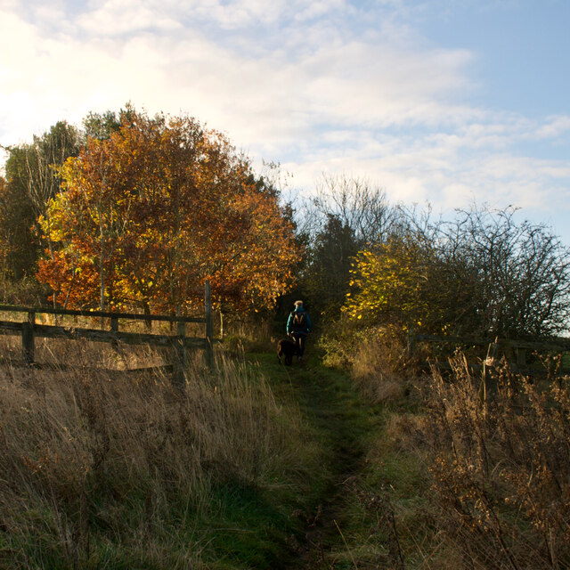
Banesley Lane Plantation, located in Durham, is a picturesque woodland area renowned for its natural beauty and diverse ecosystem. Situated in the northeastern region of England, this plantation covers a vast area of dense forest and is a popular destination for nature enthusiasts, hikers, and wildlife photographers.

The plantation is characterized by its rich and varied vegetation, including a mix of deciduous and coniferous trees, creating a vibrant tapestry of colors throughout the seasons. Towering oak, beech, and ash trees dominate the landscape, providing a verdant canopy that shelters a multitude of plant and animal species.

Wildlife thrives in Banesley Lane Plantation, with numerous bird species, such as woodpeckers, thrushes, and owls, making the woodlands their home. Squirrels, rabbits, and foxes can also be spotted amidst the undergrowth, adding to the area's natural charm.

For visitors seeking a tranquil escape, Banesley Lane Plantation offers a network of well-maintained footpaths and trails, allowing them to explore the beauty of the woodland at their own pace. The plantation also provides picnic areas and designated spots for birdwatching, making it an ideal destination for a day out with family and friends.

Managed by local conservation organizations, Banesley Lane Plantation is committed to preserving its natural heritage and promoting environmental education. Regular guided walks and workshops are organized to raise awareness about the importance of sustainable forestry and the protection of native wildlife.

In conclusion, Banesley Lane Plantation is a captivating woodland retreat in Durham that offers visitors an opportunity to immerse themselves in nature's wonders. Its stunning scenery, diverse flora and fauna, and commitment to conservation make it a must-visit destination for both locals and tourists alike.

If you have any feedback on the listing, please let us know in the comments section below.

Banesley Lane Plantation Images

Images are sourced within 2km of 54.915179/-1.6393587 or Grid Reference NZ2357. Thanks to Geograph Open Source API. All images are credited.

Footpath to Hedley Lane
Site of former reservoir
Road junctions below the A1 The roundabout for access to the A1 and the road on the left into Team Valley
Road junctions below the A1
The roundabout for access to the A1 and the road on the left into Team Valley
A corner of the Team Valley Retail Park
Team Valley Retail World A view of the retail park with low, dark, swirling cloud
Team Valley Retail World
A view of the retail park with low, dark, swirling cloud
Silverhills Nursery A view of the farm and the side of the greenhouses of Silverhills Nursery. The farm has cross country biking tracks
Silverhills Nursery
A view of the farm and the side of the greenhouses of Silverhills Nursery. The farm has cross country biking tracks
Old Ravensworth Farm A view of the entrance to the farm with the sprawl of southern Gateshead in the distance.
Old Ravensworth Farm
A view of the entrance to the farm with the sprawl of southern Gateshead in the distance.
Blackburn Fell A view of the fell from the Tyne-Wear Trail.
Blackburn Fell
A view of the fell from the Tyne-Wear Trail.
Silverhills Newly built farm buildings on the Lamesley-Sunniside road
Silverhills
Newly built farm buildings on the Lamesley-Sunniside road
The Marquis Of Granby The pub is on the Lobley Hill to Sunniside road.
The Marquis Of Granby
The pub is on the Lobley Hill to Sunniside road.
Team Valley Retail World 2 A picture of the retail park with less threatening cloud!
Team Valley Retail World 2
A picture of the retail park with less threatening cloud!
Field, looking SE towards Ravensworth Grange ...and beyond!
Field, looking SE towards Ravensworth Grange
...and beyond!
St. Andrew, Lamesley
St. Andrews Lamesley church gates
Coach Road Looking north along the Coach Road that runs between the A1 and Ravensworth Castle
Coach Road
Looking north along the Coach Road that runs between the A1 and Ravensworth Castle
Derelict building (and horses) There are no obvious clues to the original use of this structure on the lefthand side (going south) of the minor road between Sunniside and High Urpeth, just after the junction with the A 6076. However, a local resident has revealed that the building was actually a cattle holding station - the paddock has gone- for loading up to go to market. The rather unfriendly sign is out of place in an area crisscrossed by public footpaths and bridleways.
Derelict building (and horses)
There are no obvious clues to the original use of this structure on the lefthand side (going south) of the minor road between Sunniside and High Urpeth, just after the junction with the A 6076. However, a local resident has revealed that the building was actually a cattle holding station - the paddock has gone- for loading up to go to market. The rather unfriendly sign is out of place in an area crisscrossed by public footpaths and bridleways.
Footpath with carved stone This marks the point where the Great North Forest Trail crosses Birkland Lane. Here the trail follows the course of the old  Pontop and Jarrow Railway. Birkhead Cottages can just be seen through the mist.
Footpath with carved stone
This marks the point where the Great North Forest Trail crosses Birkland Lane. Here the trail follows the course of the old Pontop and Jarrow Railway. Birkhead Cottages can just be seen through the mist.
Birkheads Lanes Nursery Garden Nursery with mining tradition
Birkheads Lanes Nursery Garden
Nursery with mining tradition
Show me another place!

Banesley Lane Plantation is located at Grid Ref: NZ2357 (Lat: 54.915179, Lng: -1.6393587)

Unitary Authority: Gateshead

Police Authority: Northumbria

What 3 Words

///march.ducks.surpassed. Near Lamesley, Tyne & Wear

Related Wikis

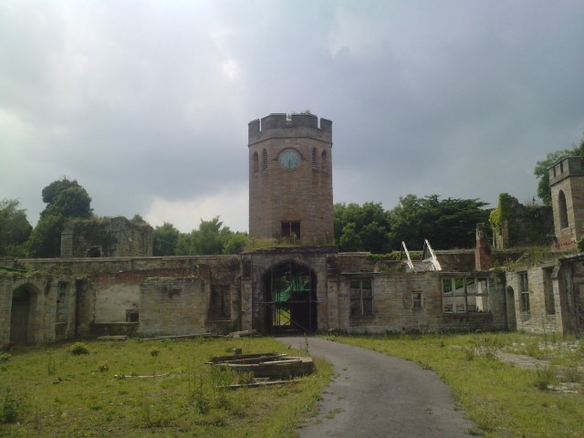
Ravensworth Castle, Lamesley

Ravensworth Castle is a ruinous Grade II* listed building and a Scheduled Ancient Monument situated at Lamesley, Tyne and Wear, England. The building has...

Kibblesworth

Kibblesworth is a village 2 miles (3.2 km) west of Birtley, Tyne and Wear, England. Kibblesworth was a mainly rural community until the development of...

Lamesley

Lamesley is a village and civil parish in the Metropolitan Borough of Gateshead, Tyne and Wear, England. The population of the civil parish at the 2011...

Team Valley

Team Valley is a trading estate located in Gateshead. It is home to the Retail World retail park, with many large, international companies based in the...

Nearby Amenities

Located within 500m of 54.915179,-1.6393587
Power: tower
Lat/Long: 54.9138773/-1.6339632
Power: tower
Source: Bing
Lat/Long: 54.9160232/-1.6371976
Power: tower
Lat/Long: 54.9179819/-1.6401499
Barrier: yes
Lat/Long: 54.9169856/-1.6377722
The data included in this document is from www.openstreetmap.org. The data is made available under ODbL.

Have you been to Banesley Lane Plantation?

Leave your review of Banesley Lane Plantation below (or comments, questions and feedback).